Martin's Additions, Maryland

Last updated
Martin's Additions, Maryland
Martins Additions sign entrance village MD 2021-05-31 134933 1.jpg
Entrance sign at the corner of Brookville Road and Quincy Street
Seal of Martin's Additions, Maryland.png
Montgomery County Maryland Incorporated and Unincorporated areas Martin's Additions Highlighted.svg
Coordinates: 38°58′47″N77°4′10″W / 38.97972°N 77.06944°W / 38.97972; -77.06944
Country Flag of the United States.svg United States
State Flag of Maryland.svg  Maryland
County Montgomery
Special Tax District1916
Incorporated March 19, 1985 [1]
Government
  Village ManagerNiles Anderegg
Area
[2]
  Total0.14 sq mi (0.36 km2)
  Land0.14 sq mi (0.36 km2)
  Water0.00 sq mi (0.00 km2)
Elevation
338 ft (103 m)
Population
 (2020)
  Total946
  Density6,855.07/sq mi (2,642.44/km2)
Time zone UTC-5 (Eastern (EST))
  Summer (DST) UTC-4 (EDT)
ZIP code
20815 [3]
Area code(s) 240 and 301
FIPS code 24-50965
GNIS feature ID1669431
Website martinsadditions.org

Martin's Additions is a village in Montgomery County, Maryland, United States. It was established as a Special Tax District in 1916 and incorporated as a village in 1985. The population was 946 at the 2020 Census. [4]

Contents

The town is part of a larger community, colloquially referred to as Chevy Chase, that includes several adjoining settlements in Montgomery County and one neighborhood of Washington, D.C.

Geography

Martin's Additions is located at 38°58′47″N77°4′10″W / 38.97972°N 77.06944°W / 38.97972; -77.06944 (38.979713, 77.069349). [5]

According to the United States Census Bureau, the village has a total area of 0.14 square miles (0.36 km2), all of it land. [6]

History

In 1896, Harry M. Martin began buying land from the Chevy Chase Land Company and others and called his holdings "Martin's Additions to Chevy Chase". [7]

In 1916, the area was incorporated as the special tax district of Martin's First, Second, Third and Fourth Additions to the Village of Chevy Chase. [7]

In February 1985, the residents voted in a referendum on whether to incorporate as a town. [8] The vote was 198 to 15 in favor of incorporation. [8] Following approval of Montgomery County and the U.S. state of Maryland, the special tax district was incorporated as a municipality called the Village of Martin's Additions on March 19, 1985. [7] The first elected village council members were Michael E. Zielinski, Edward C. Holland, Lucy Foa, Karen McManus, and Paul S. Weller. [8]

Demographics

Historical population
CensusPop.Note
1990 846
2000 8753.4%
2010 9336.6%
2020 9461.4%
U.S. Decennial Census [9]

2020 census

As of the census [10] of 2020, there were 946 people, 342 households and 202 families living in the village. The population density was 6,757.1 inhabitants per square mile (2,608.9/km2). There were 330 housing units at an average density of 2,357.1 per square mile (910.1/km2). The racial makeup of the village was 88.8% White, 1.8% African American, 3.4% Asian, 0.0% Pacific Islander, 0.7% from other races, and 5.2% from two or more races. Hispanic or Latino of any race were 3.4% of the population.

There were 342 households, of which 36.0% had children under the age of 18 living with them, 76.9% were married couples living together, 16.4% had a female householder with no husband present and 6.7% had a male householder with no wife present. 10.5% of all households were made up of individuals, and 6.7% had someone living alone who was 65 years of age or older. The average household size was 3.18 and the average family size was 3.35

The median age in the village was 43.6 years. 24.1% of residents were under the age of 18; 8.0% were between the ages of 18 and 24; 19.0% were from 25 to 44; 26.5% were from 45 to 64; and 22.5% were 65 years of age or older. The gender makeup of the village was 50.4% male and 49.6% female.

2010 census

As of the census [10] of 2010, there were 933 people, 321 households, and 269 families living in the village. The population density was 6,664.3 inhabitants per square mile (2,573.1/km2). There were 329 housing units at an average density of 2,350.0 per square mile (907.3/km2). The racial makeup of the village was 92.7% White, 0.6% African American, 3.8% Asian, 0.5% Pacific Islander, 0.9% from other races, and 1.5% from two or more races. Hispanic or Latino of any race were 3.2% of the population.

There were 321 households, of which 44.2% had children under the age of 18 living with them, 76.0% were married couples living together, 5.9% had a female householder with no husband present, 1.9% had a male householder with no wife present, and 16.2% were non-families. 13.4% of all households were made up of individuals, and 6.6% had someone living alone who was 65 years of age or older. The average household size was 2.91 and the average family size was 3.19.

The median age in the village was 44.3 years. 30.4% of residents were under the age of 18; 3.6% were between the ages of 18 and 24; 17.3% were from 25 to 44; 33.1% were from 45 to 64; and 15.8% were 65 years of age or older. The gender makeup of the village was 49.1% male and 50.9% female.

2000 census

As of the census [11] of 2000, there were 875 people, 309 households, and 258 families living in the village. The population density was 6,524.6 inhabitants per square mile (2,519.2/km2). There were 312 housing units at an average density of 2,326.5 per square mile (898.3/km2). The racial makeup of the village was 95.66% White, 0.11% African American, 1.26% Asian, 0.91% from other races, and 2.06% from two or more races. Hispanic or Latino of any race were 3.31% of the population.

There were 309 households, out of which 46.0% had children under the age of 18 living with them, 73.5% were married couples living together, 7.4% had a female householder with no husband present, and 16.2% were non-families. 14.6% of all households were made up of individuals, and 8.1% had someone living alone who was 65 years of age or older. The average household size was 2.83 and the average family size was 3.13.

In the village, the population was spread out, with 31.9% under the age of 18, 2.3% from 18 to 24, 20.8% from 25 to 44, 32.0% from 45 to 64, and 13.0% who were 65 years of age or older. The median age was 42 years. For every 100 females, there were 93.2 males. For every 100 females age 18 and over, there were 88.0 males.

The median income for a household in the village was $135,443, and the median income for a family was $144,939. Males had a median income of $100,000 versus $91,112 for females. The per capita income for the village was $59,502. About 1.5% of families and 1.2% of the population were below the poverty line, including 2.1% of those under age 18 and none of those age 65 or over.

Transportation

Summit Avenue, a typical street in Martin's Additions 2019-06-12 11 56 44 View north along Summit Avenue at Taylor Street in Martin's Additions, Montgomery County, Maryland.jpg
Summit Avenue, a typical street in Martin's Additions

No state highways serve Martin's Additions directly, with all streets being both residential and locally maintained. The closest state highway is Maryland Route 186 (Brookville Road) which passes just west of the village border.

Education

Martin's Additions is served by the Montgomery County Public Schools.

The village is zoned to:

Related Research Articles

<span class="mw-page-title-main">Rosemont, Maryland</span> Village in Maryland

Rosemont is a village in Frederick County, Maryland, United States. The population was 272 at the 2020 census. Maryland state routes 79 and 871 pass through Rosemont.

<span class="mw-page-title-main">Chevy Chase Section Five, Maryland</span> Village in Maryland, United States

Chevy Chase Section Five is an incorporated village in Montgomery County, Maryland, United States. The population was 672 at the 2020 census.

<span class="mw-page-title-main">Chevy Chase Section Three, Maryland</span> Village in Maryland, United States

Chevy Chase Section Three is a village in Montgomery County, Maryland, United States. It was organized as a special tax district in 1916 and incorporated as a village in 1982. The population was 802 at the 2020 census.

<span class="mw-page-title-main">Chevy Chase View, Maryland</span> Town in Maryland, United States

Chevy Chase View is a town in Montgomery County, Maryland, United States. Established as a Special Tax District in 1924, the town was formally incorporated on October 28, 1993. The population was 1,005 at the 2020 census.

<span class="mw-page-title-main">Chevy Chase Village, Maryland</span> Town in Maryland, United States

Chevy Chase Village is an incorporated municipality in Montgomery County, Maryland, United States, bordering Washington, D.C. The population was 2,049 as of the 2020 census. The town was the wealthiest in Maryland as of 2017, with a median income of over $250,000, the highest income bracket listed by the census bureau, and a median home value of $1,823,800.

<span class="mw-page-title-main">North Chevy Chase, Maryland</span> Village in Maryland, United States

North Chevy Chase is a incorporated village in Montgomery County, Maryland, United States. It was established as a special tax district in 1924 and incorporated as a village in 1996. The population was 682 at the 2020 census, up from 519 in 2010.

<span class="mw-page-title-main">Martin, Michigan</span> Village in Michigan, United States

Martin is a village in southeastern Allegan County in the U.S. state of Michigan. The population was 377 at the 2020 census.

<span class="mw-page-title-main">Westwood, Missouri</span> Village in Missouri, United States

Westwood is a village in west St. Louis County, Missouri, United States. The population was 316 at the 2020 census.

<span class="mw-page-title-main">Castalia, Ohio</span> Village in Ohio, United States

Castalia is a village in Erie County, Ohio, United States. The population was 774 at the 2020 census. It is part of the Sandusky, Ohio Metropolitan Statistical Area.

<span class="mw-page-title-main">Addyston, Ohio</span> Village in Ohio, United States

Addyston is a village in Miami Township, Hamilton County, Ohio, United States. Located along the Ohio River, it is a western suburb of the neighboring city of Cincinnati. The population was 927 at the 2020 census.

<span class="mw-page-title-main">Newtown, Ohio</span> Village in Ohio, United States

Newtown is a village in southeastern Hamilton County, Ohio, United States, near Cincinnati. The population was 2,702 at the 2020 census. Newtown was settled in 1792 and incorporated as a village in 1901.

<span class="mw-page-title-main">Hartville, Ohio</span> Village in Ohio, United States

Hartville is a village in northern Stark County, Ohio, United States. The population was 3,329 at the 2020 census. It is part of the Canton–Massillon metropolitan area. Hartville lies halfway between Akron and Canton at the intersection of State Routes 43 and 619.

<span class="mw-page-title-main">White Township, Indiana County, Pennsylvania</span> Township in Pennsylvania, United States

White Township is a township in Indiana County, Pennsylvania, United States. The population was 15,242 at the 2020 census.

<span class="mw-page-title-main">Shorewood Hills, Wisconsin</span> Village in Wisconsin, United States

Shorewood Hills is a village in Dane County, Wisconsin, United States. It was established in 1927. The population was 2,169 at the 2020 census. Entirely surrounded by the city of Madison and Lake Mendota, it is part of the Madison Metropolitan Statistical Area.

<span class="mw-page-title-main">Oostburg, Wisconsin</span> Village in Wisconsin, United States

Oostburg is a village in Sheboygan County, Wisconsin, United States. The population was 3,056 at the 2020 census. It is included in the Sheboygan, Wisconsin Metropolitan Statistical Area.

<span class="mw-page-title-main">Washingtonville, Ohio</span> Village in Ohio, United States

Washingtonville is a village in northern Columbiana and southern Mahoning counties in the U.S. state of Ohio. The population was 712 at the 2020 census. Southern Washingtonville is included in the Salem micropolitan area, while northern Washingtonville is part of the Youngstown–Warren metropolitan area.

<span class="mw-page-title-main">Harrisburg, Ohio</span> Village in Ohio, United States

Harrisburg is a village in Franklin and Pickaway counties in the U.S. state of Ohio. The population was 315 at the 2020 census.

<span class="mw-page-title-main">Chevy Chase (town), Maryland</span> Town in Montgomery County, Maryland, US

Chevy Chase —formally, the Town of Chevy Chase—is an incorporated town in Montgomery County, Maryland, United States. The population was 2,904 at the 2020 census.

<span class="mw-page-title-main">Chevy Chase (CDP), Maryland</span> Census-designated place in Maryland, United States

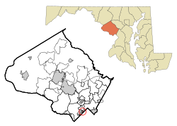
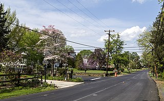
Chevy Chase is a census-designated place (CDP) in Montgomery County, Maryland, United States. The population was 10,176 at the 2020 census.

<span class="mw-page-title-main">Wilton, Wisconsin</span> Village in Wisconsin, United States

Wilton is a village in Monroe County, Wisconsin, United States. The population was 504 at the 2010 census. The village is located partially within the Town of Wilton and partially within the Town of Wellington.

References

  1. "Martin's Additions". Maryland Manual. Retrieved 27 June 2017.
  2. "2020 U.S. Gazetteer Files". United States Census Bureau. Retrieved April 26, 2022.
  3. "Martin's Additions MD ZIP Code". zipdatamaps.com. 2023. Retrieved February 17, 2023.
  4. "Explore Census Data". data.census.gov. Retrieved 2022-04-24.
  5. "US Gazetteer files: 2010, 2000, and 1990". United States Census Bureau. 2011-02-12. Retrieved 2011-04-23.
  6. "US Gazetteer files 2010". United States Census Bureau. Archived from the original on 2012-07-02. Retrieved 2013-01-25.
  7. 1 2 3 Linda M. Burrell et al., eds. Maryland's 157: The Incorporated Cities and Towns. Annapolis, MD: Maryland Municipal League, 2000. p. 208.
  8. 1 2 3 Moncada, Carlos. "Village May Become Town". The Washington Post. February 14, 1985. p. MD20.
  9. "Census of Population and Housing". Census.gov. Retrieved June 4, 2015.
  10. 1 2 "Explore Census Data". data.census.gov. Retrieved 2022-04-24.PD-icon.svg This article incorporates text from this source, which is in the public domain .
  11. "U.S. Census website". United States Census Bureau . Retrieved 2008-01-31.