The Lower Suwannee National Wildlife Refuge (LSNWR) is part of the United States National Wildlife Refuge System. It is located in southeastern Dixie and northwestern Levy counties on the western coast of Florida, approximately fifty miles southwest of the city of Gainesville.

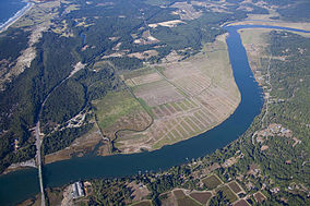
The Billy Frank Jr. Nisqually National Wildlife Refuge is a wildlife preserve operated by the United States Fish and Wildlife Service on the Nisqually River Delta near Puget Sound in northeastern Thurston County, Washington and northwestern Pierce County, Washington. The refuge is located just off Interstate 5, between the cities of Tacoma and Olympia.
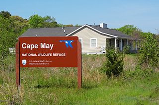
The Cape May National Wildlife Refuge is a protected area on the Cape May Peninsula in Cape May County, New Jersey. It is part of the National Wildlife Refuge System and managed by the United States Fish and Wildlife Service. Established in January 1989 with 90 acres (0.36 km2) acquired from the Nature Conservancy, it has since grown to more than 11,000 acres (45 km2) in size, and plans call for its further expansion to more than 21,200 acres (86 km2). It comprises three distinct and non-contiguous units: the Delaware Bay Division, the Great Cedar Swamp Division and the Two Mile Beach Unit. Located in the Middle Atlantic coastal forests ecoregion, the cape provides habitat for large numbers of migratory birds.
The John Heinz National Wildlife Refuge at Tinicum is a 1000-acre (4.05 km2) National Wildlife Refuge in Philadelphia and Tinicum Township, Delaware County, in Pennsylvania. Adjacent to the Philadelphia International Airport, the refuge serves to protect the largest remaining freshwater tidal marsh in Pennsylvania. Established in 1972 as the Tinicum National Environmental Center, it was renamed in 1991 after the late H. John Heinz III who had helped preserve Tinicum Marsh.
The Stewart B. McKinney National Wildlife Refuge is a 950-acre (384.5 ha) National Wildlife Refuge in ten units across the U.S. state of Connecticut. Located in the Atlantic Flyway, the refuge spans 70 miles (110 km) of Connecticut coastline and provides important resting, feeding, and nesting habitat for many species of wading birds, shorebirds, songbirds and terns, including the endangered roseate tern. Adjacent waters serve as wintering habitat for brant, scoters, American black duck, and other waterfowl. Overall, the refuge encompasses over 900 acres (364.2 ha) of barrier beach, intertidal wetland and fragile island habitats.
The Seal Beach National Wildlife Refuge is a wildlife refuge encompassing 965 acres (3.91 km2) located in the California coastal community of Seal Beach. Although it is located in Orange County it is included as part of the San Diego National Wildlife Refuge Complex. It was established in 1972.

The Rachel Carson National Wildlife Refuge is a 9,125-acre (37 km2) National Wildlife Refuge made up of several parcels of land along 50 miles (80 km) of Maine's southern coast. Created in 1966, it is named for environmentalist and author Rachel Carson, whose book Silent Spring raised public awareness of the effects of DDT on migratory songbirds, and of other environmental issues.
The Oregon Coast National Wildlife Refuge Complex consists of six National Wildlife Refuges along the Oregon Coast. It provides wilderness protection to thousands of small islands, rocks, reefs, headlands, marshes, and bays totaling 371 acres spanning 320 miles (515 km) of Oregon's coastline. The areas are all managed by the United States Fish and Wildlife Service.
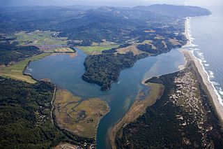
Nestucca Bay National Wildlife Refuge is a U.S. National Wildlife Refuge on Oregon's coast. It lies in southern Tillamook County, on the state's northern coast. It is one of six National Wildlife Refuges comprising the Oregon Coast National Wildlife Refuge Complex and supports one tenth of the world's dusky Canada goose population. The refuge contains at least seven types of habitat, including tidal marsh, tidal mudflats, grassland, woodland, pasture, forested lagg—a transition between raised peat bog and mineral soil—and freshwater bogs, including the southernmost coastal Sphagnum bog habitat on the Pacific Coast.

Willapa National Wildlife Refuge is a National Wildlife Refuge located on the shores of Willapa Bay in Washington, United States. It comprises 11,000 acres (45 km2) of sand dunes, sand beaches, mudflats, grasslands, saltwater and freshwater marshes, and coniferous forest. The refuge includes Long Island with stands of old growth Western red cedar and hemlock.
The Blackbeard Island National Wildlife Refuge is a 5,618 acre National Wildlife Refuge located in McIntosh county in Georgia. The refuge was established to provide a nature and forest preserve for aesthetic and conservation purposes.

The Chincoteague National Wildlife Refuge is a 14,000-acre (57 km2) wildlife preserve operated by the U.S. Fish & Wildlife Service. It is primarily located on the Virginia half of Assateague Island with portions located on the Maryland side of the island, as well as Morris Island and Wildcat Marsh. The refuge contains a large variety of wildlife animals and birds, including the Chincoteague Pony. The purpose of the refuge is to maintain, regulate and preserve animal and plant species as well as their habitats for present and future generations.

Mary's Point is a 12 square kilometres (4.6 sq mi) wetland in Albert County, New Brunswick, Canada. It is at the head of the Bay of Fundy, just outside the small community of Harvey and approximately 40 km (25 mi) south of Moncton. Designated a Ramsar wetland of international importance on May 24, 1982, it is also part of the Fundy biosphere reserve established in 2007, which also contains the Shepody Bay wetland. It was also the first Canadian site in the Western Hemisphere Shorebird Reserve, as part of the Bay of Fundy Hemisphere Shorebird Reserve. It is within the Shepody Bay National Wildlife Area, which is administered by the Canadian Wildlife Service.
The Delta National Wildlife Refuge is located 10 miles (16 km) east of Venice, Louisiana along the Mississippi River. The area formed when a breach in the natural levee of the Mississippi River occurred in 1862 approximately 100 miles (160 km) below New Orleans, Louisiana. The 48,000-acre (190 km2) refuge was purchased in 1935 with the primary purpose to provide sanctuary and habitat to wintering waterfowl. Access is by boat only.

The Sonny Bono Salton Sea National Wildlife Refuge is located in the Imperial Valley of California, 40 miles (64 km) north of the Mexican border. Situated at the southern end of the Salton Sea, the refuge protects one of the most important nesting sites and stopovers along the Pacific Flyway. Despite its location in the Colorado Desert, a subdivision of the larger Sonoran Desert, the refuge contains marine, freshwater, wetland, and agricultural habitats which provide sanctuary for hundreds of birds and wetland species, including several that have been listed as endangered or sensitive by the U.S. Fish and Wildlife Service.
Kakahaiʻa National Wildlife Refuge (NWR) was established in 1977 to permanently protect wetland habitat for endangered endemic waterbirds and wintering migratory wetland birds and to maintain the structural integrity of an ancient Hawaiian fishpond.
Maine Coastal Islands National Wildlife Refuge contains more than 50 offshore islands and four coastal parcels, totaling more than 8,100 acres. The complex spans more than 250 miles of Maine coastline and includes five national wildlife refuges — Petit Manan, Cross Island, Franklin Island, Seal Island, and Pond Island. The U.S. Fish and Wildlife Service manages the refuge complex as part of the National Wildlife Refuge System.

The Elizabeth A. Morton National Wildlife Refuge is a 187-acre (76 ha) National Wildlife Refuge in Noyack, New York. Much of the refuge is situated on a peninsula surrounded by Noyack and Little Peconic bays. The refuge is managed by the United States Fish and Wildlife Service as part of the Long Island National Wildlife Refuge Complex.

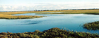
Grays Harbor National Wildlife Refuge is located within Grays Harbor, at the mouth of the Chehalis River, which makes up the second largest watershed in Washington. It is one of four major staging areas for migrating shorebirds in the Pacific Flyway. Up to one million shorebirds gather here in spring and fall to feed and rest.

San Diego Bay National Wildlife Refuge is an urban refuge located on San Diego Bay in San Diego County, California. It is part of the San Diego National Wildlife Refuge Complex. It was dedicated in June 1999.