
Battle Ground Lake State Park is a 275-acre (111 ha) public recreation area located three miles (4.8 km) northeast of the city of Battle Ground, Washington. The state park is covered by an evergreen forest located around a crater lake of volcanic origin. The park is managed by the Washington State Parks and Recreation Commission.
Harris Beach State Park is an Oregon State Park located on US Highway 101, north of Brookings. The day-use area offers a restroom and picnic area with tables, and the campground has RV sites, yurts and tent sites available year-round.

The Deschutes River State Recreation Area is a park at the confluence of the Deschutes and Columbia rivers in the U.S. state of Oregon. It is a few miles east of The Dalles. The 35.1-acre (14.2 ha) park offers opportunities for camping, fishing, hiking, mountain biking, and equestrian trail riding.

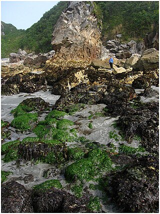
Alfred A. Loeb State Park is a state park in the U.S. state of Oregon, administered by the Oregon Parks and Recreation Department. Located on the banks of the Chetco River, the park offers camping, hiking, fishing, swimming, and rafting opportunities. In the parks boundaries are 3 rental cabins, 53 camping sites, a launch area for drift boats, a day-use area, and the head of a 0.75-mile (1.2 km) trail that the official Web site says leads to northernmost coastal redwood grove in the United States.
Bolon Island Tideways State Scenic Corridor is a state park in the U.S. state of Oregon, administered by the Oregon Parks and Recreation Department. The 11.4-acre (4.6 ha) park is on Bolon Island 10 river miles (16 km) from the mouth of the Umpqua River and north of Reedsport. It is along Highway 101 and near the site, where in 1828, most of Jedediah Smith's party were massacred. The land was given to the state in 1934 by William C. and Jennie D. Chamberlain.

Cascadia State Park is a state park in the U.S. state of Oregon near Sweet Home along the South Santiam River at Cascadia. The park includes a day use area, campsites, hiking trails and 150 foot Lower Soda Creek Falls.

Cline Falls State Scenic Viewpoint is a state park near Redmond, Oregon, United States. It is located on the Deschutes River. The park covers 9 acres (36,000 m2). It is administered by the Oregon Parks and Recreation Department.

D River State Recreation Site is a state park in the U.S. state of Oregon, administered by the Oregon Parks and Recreation Department. It is a sandy beach of the Pacific Ocean within central Lincoln City along the length of the 120-foot (37 m) long D River, one of the world's shortest rivers.
Dexter State Recreation Site is a state park in the U.S. state of Oregon, administered by the Oregon Parks and Recreation Department.

Elijah Bristow State Park is a state park in the U.S. state of Oregon, administered by the Oregon Parks and Recreation Department. It has more than 10 miles (16 km) of well-maintained trails along ponds, wetlands, meadows, and the Middle Fork Willamette River, and through forests of broadleaf and evergreen trees. The trails are open to horses, hikers, and mountain bikers, and there is a separate equestrian staging area popular with riding clubs.
Fall Creek State Recreation Site is a state park in the U.S. state of Oregon, administered by the Oregon Parks and Recreation Department. The park includes 47 campsites that do not include many luxuries. Each site includes a picnic table and a fire ring. There is also a designated swimming area in the lake that Fall Creek flows into. A dock and boat ramp are on the lake as well.

Gleneden Beach State Recreation Site is a state park administered by the Oregon Parks and Recreation Department in the U.S. state of Oregon. Located along the Pacific Ocean 7 miles (11 km) south of Lincoln City, it offers public beach access, picnicking, and fishing in a setting of shore pines, sandstone bluffs, and sand. The park is fee-free.

Jasper State Recreation Site is a state park in the U.S. state of Oregon, administered by the Oregon Parks and Recreation Department.

Koberg Beach State Recreation Site is a state park in Hood River County, Oregon United States, administered by the Oregon Parks and Recreation Department. The park offers a wayside rest area for west bound traffic on Interstate 84.

Lowell State Recreation Site is a state park in the U.S. state of Oregon, administered by the Oregon Parks and Recreation Department.

Manhattan Beach State Recreation Site is a state park in the U.S. state of Oregon. Administered by the Oregon Parks and Recreation Department, the park is open to the public and is fee-free. Amenities at the park, which is 2 miles (3 km) north of Rockaway Beach along U.S. Route 101, include picnicking, fishing, and a Pacific Ocean beach.
McVay Rock State Recreation Site is a state park in the U.S. state of Oregon, administered by the Oregon Parks and Recreation Department.

Munson Creek Falls State Natural Site is a state park in the U.S. state of Oregon, administered by the Oregon Parks and Recreation Department. The park contains Munson Creek Falls, which is the tallest waterfall in Oregon's Coast Range. A short hike of 0.5 miles (0.80 km) leads to views of the 319 feet (97 m) waterfall.

Washburne State Wayside is a state park 4 miles (6 km) northwest of Junction City, in the U.S. state of Oregon. Administered by the Oregon Parks and Recreation Department, the wayside serves as a rest stop for travelers on Oregon Route 99W and interpretive center for the Applegate Trail. The state bought the land for the park in 1926 from William C. and Mae E. Washburne. It lies on the border between Lane and Benton counties.

Hilgard is an unincorporated community in Union County, Oregon, United States, at the junction of Oregon Route 244 with Interstate 84/U.S. Route 30, near the Grande Ronde River. It is also the site of a junction (wye) of the Union Pacific Railroad. Hilgard Junction State Recreation Area is across the river from the community.


