
The Oregon Coast is a coastal region of the U.S. state of Oregon. It is bordered by the Pacific Ocean to its west and the Oregon Coast Range to the east, and stretches approximately 362 miles (583 km) from the California state border in the south to the Columbia River in the north. The region is not a specific geological, environmental, or political entity, and includes the Columbia River Estuary.
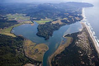
Nestucca Bay is a bay formed by the confluence of the Nestucca River and the Pacific Ocean in northwest Oregon in the United States. It is near the town of Pacific City, which is in southwestern Tillamook County, about 12 miles (19 km) south of Cape Lookout. The bay is a bar-built estuary and totals 1,000 acres (4.0 km2) in area.
Cape Lookout is a sharp rocky promontory along the Pacific Ocean coast of northwestern Oregon in the United States. It is located in southwestern Tillamook County, approximately 10 miles (16 km) southwest of Tillamook, just south of Netarts Bay. The promontory extends 1.5 miles (2.4 km) perpendicular to the coast, and is approximately 0.5 miles (0.80 km) wide at its base, tapering as it extends outward from the coast. Cape Lookout State Park is located on the north side of the promontory, which is part of the Siuslaw National Forest. Cape Lookout Road travels past the base of the cape. Cape Lookout is a member of Tillamook's Three Capes Scenic Drive.

The Tillamook River is a stream, about 17 miles (27 km) long, near the coast of northwest Oregon in the United States. It drains an oceanside valley in the foothills of the Northern Oregon Coast Range west of Portland and empties into the Pacific Ocean via Tillamook Bay. It is one of five rivers—the Tillamook, the Trask, the Wilson, the Kilchis, and the Miami—that flow into the bay.
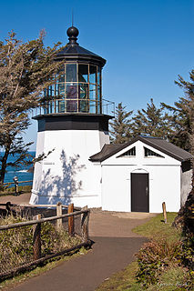
The Cape Meares Light is an inactive lighthouse on the coast of Oregon. It is located on Cape Meares just south of Tillamook Bay. It is open to the public.
Cape Meares is a small headland on the Pacific coast in Tillamook County, Oregon, United States. The cape forms a high steep bluff on the south end of Tillamook Bay, approximately five miles (8 km) northwest of the city of Tillamook. Much of the cape is part of the Oregon Parks and Recreation Department-administered Cape Meares State Scenic Viewpoint with three miles of hiking trails, which includes Cape Meares Light and the Octopus Tree. The cape is named after John Meares, a British explorer.
Tillamook Head is a high promontory on the Pacific coast of northwest Oregon in the United States. It is located in west-central Clatsop County, approximately 5 mi (8 km) southwest of Seaside. The promontory forms a steep rocky bluff on the ocean, approximately 1,200 ft high, forested with Sitka spruce. It is located in Ecola State Park.

The Oregon Coast Trail (OCT) is a long-distance hiking route along the Pacific coast of the U.S. state of Oregon in the United States. It follows the coast of Oregon from the mouth of the Columbia River to the California border south of Brookings.

The Lewis and Clark National Historical Park, located in the vicinity of the mouth of the Columbia River, commemorates the Lewis and Clark Expedition. Administration of the park, which includes both federal and state lands, is a cooperative effort of the National Park Service and the states of Oregon and Washington. The National Historical Park was dedicated on November 12, 2004.

U.S. Route 101 (US 101), is a major north–south U.S. Highway in Oregon that runs through the state along the coastline near the Pacific Ocean. It runs from the California border, south of Brookings, to the Washington state line on the Columbia River, between Astoria, Oregon, and Megler, Washington.

Cape Kiwanda State Natural Area is a state park in Pacific City, Oregon, United States. Cape Kiwanda is on the Three Capes Scenic Route, which includes Cape Meares and Cape Lookout. Hiking to the top of Cape Kiwanda allows views of Nestucca Bay to the south and Cape Lookout to the north.
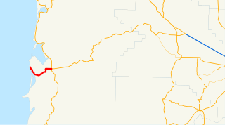
Oregon Route 131 (OR 131), known as the Netarts Highway No. 131, is a state highway in the U.S. state of Oregon. The route runs from the coastal community of Oceanside to an intersection with U.S. Route 101 (US 101) and OR 6 in Tillamook, Oregon. The highway is 9.02 miles (14.52 km) long. Netarts Highway No. 131 was established in 1940, and was designated OR 131 in 2002.

The Tillamook State Forest is a 364,000-acre (1,470 km2) publicly owned forest in the U.S. state of Oregon. Managed by the Oregon Department of Forestry, it is located 40 miles (64 km) west of Portland in the Northern Oregon Coast Range, and spans Washington, Tillamook, Yamhill, and Clatsop counties. The forest receives large amounts of precipitation and is dominated by Douglas-fir trees. Activities include commercial logging, recreation, and other commercial resource extraction activities such as mushroom hunting.
The Tillamook are a Native American tribe from coastal Oregon of the Salish linguistic group. The name "Tillamook" is a Chinook language term meaning "people of [the village] Nekelim ", sometimes it is given as a Coast Salish term, meaning "Land of Many Waters". The Tillamook tribe consists of several divisions and dialects, including :

Cape Sebastian State Scenic Corridor is a state park in the U.S. state of Oregon, administered by the Oregon Parks and Recreation Department.

Cape Arago State Park is a state park in the U.S. state of Oregon, administered by the Oregon Parks and Recreation Department. Cape Arago is north of Bandon and 15 miles southwest of Coos Bay on Cape Arago Highway in Coos County.

Neskowin Beach State Recreation Site is a state park in Tillamook County, Oregon, United States, administered by the Oregon Parks and Recreation Department.

Oceanside Beach State Recreation Site is a state park in the U.S. state of Oregon. Administered by the Oregon Parks and Recreation Department, the park is open to the public and is fee-free. Amenities at the site, in the unincorporated community of Oceanside, include picnicking, wildlife watching, fishing, windsurfing, and kite flying. It is not uncommon to see paraglider pilots land at the beach on Southwest wind days during the fall, winter and spring. Beachcombing is popular in summer, and agate hunting is best in winter, when ocean currents remove sand. Oceanside is about 11 miles (18 km) west of Tillamook off U.S. Route 101.

Camp Meriwether is a 790-acre Boy Scout summer camp founded in 1926 and located south of Cape Lookout near Cloverdale, Oregon, along the Oregon Coast. Camp Meriwether is the largest of the Cascade Pacific Council's four resident camps in Oregon. During World War II, the camp was closed for two years and served as a US Army outpost until 1943. Since 2015, there has been controversy over the intended development of a golf course over 200 acres of the coastal land.
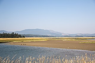
Sitka Sedge State Natural Area is an estuary and beach on the north coast of the U.S. state of Oregon in Tillamook County. Sitka Sedge consists of 357 acres (144 ha) of tidal marsh, mudflats, dunes, forested wetlands, and uplands at the south end of the Sand Lake estuary, north of Tierra Del Mar.


