Lost Forest Research Natural Area

Last updated
Lost Forest Research Natural Area
Lost Forest, Lakeview BLM, Oregon 01.jpg
Isolated pines forest environment
Lost Forest-Christmas Lake Valley map.jpg
Lost Forest in south central Oregon
Location Lake County, Oregon, United States
Nearest city Christmas Valley, Oregon
Coordinates 43°23′N120°20′W / 43.38°N 120.33°W / 43.38; -120.33 Coordinates: 43°23′N120°20′W / 43.38°N 120.33°W / 43.38; -120.33 [1]
Area8,960 acres (36.3 km2)
Established1972
Governing body Bureau of Land Management

The Lost Forest Research Natural Area is a designated forest created by the Bureau of Land Management to protect an ancient stand of ponderosa pine in the remote high desert county of northern Lake County, in the south central area of the U.S. state of Oregon. Lost Forest is an isolated area of pine trees separated from the nearest contiguous forest land by forty miles of arid desert. There are no springs or surface water in Lost Forest, and much of the southwest portion of the natural area is covered by large shifting sand dunes that are slowly encroaching on the forest.

Contents

Geology

Lost Forest is located at the northeastern corner of the Christmas Lake Basin in south central Oregon. The bedrock beneath the area was created by basalt flows laid down during the Pliocene and Pleistocene epochs. After a period of intense faulting during the middle Pleistocene, a large basin area was created by erosion and sedimentation. This basin filled with water during the wet climatic periods of the Pleistocene and post-Pleistocene. Over the past 3,200 years, the surface water in the Christmas Lake Basin has completely dried up, leaving an arid high desert environment. [2]

Today, the Lost Forest area is generally flat with gentle swales. The base elevation is 4,400 feet (1,300 m) above sea level. However, there are a number of basalt outcroppings that rise 100 to 230 feet (30 to 70 m) above the surrounding terrain. There are also large moving sand dunes in the southwest corner of the natural area. These dunes are made up of lacustrine sediments, Aeolian deposits, and alluvial materials with large amounts of volcanic pumice and ash mixed into fine sand. [3] Most of the dunes occurred west and south of the Lost Forest; however, there has been some shifting of sand from the dry lakebed of Fossil Lake through portions of the pine and juniper stands in the southwest section of the natural area. Some trees have been killed and others partially covered and then uncovered later as the sand moved through the area. While the dunes kill some trees, they do not appear to threaten the forest in general. [4]

Environment

Old growth ponderosa pine in Lost Forest Lost Forest (Ponderosa Pine), Lakeview BLM, Oregon.jpg
Old growth ponderosa pine in Lost Forest

Lost Forest covers approximately 9,000 acres (36 km2). It is a self-sustaining stand of ponderosa pines growing in the arid high desert, 40 miles (64 km) from the nearest contiguous pine forest. The Bureau of Land Management considers 4,153 acres (1,681 ha) to be prime forest land with large old-growth trees dominating the stands. Lost Forest is a remnant of an ancient ponderosa pine forest that covered much of central Oregon thousands of years ago, when the climate was cooler and wetter. Today, the Lost Forest pines survive on half the annual precipitation normally required for their species. This is possible because of the unique soil and hydrologic properties of the Lost Forest area. [4] [5] [6] [7]

The natural area's deep sandy soil has helped the Lost Forest ponderosa pines survive in the arid high desert environment. The Lost Forest soil was formed from lake sediments and alluvial materials. Pumice sands from Mount Mazama and Newberry Crater appear in the surface soils throughout the Lost Forest area. The post-Pleistocene lake environment formed the ash sediments from Mount Mazama into porous ground soil. The soils are underlain by hard calcium carbonate caliche layer several inches thick. This subsurface layer is impervious to water drainage and is seldom penetrated by roots. As a result, ground water is held near the surface. The local ponderosa pines make use the moisture held in the porous soil above the caliche barrier. In addition, scientists have found that the pine seeds from the Lost Forest trees germinated more quickly than other ponderosa pine seeds, suggesting a local adaptation to the arid environment is now a common characteristic of the Lost Forest ponderosa pine community. [2] [7]

In addition to its ponderosa pines, the Lost Forest also supports a plant community that includes big sagebrush, antelope bitterbrush, and other shrubs as well as a number of desert grasses and flowering plants. Western juniper are also common in many parts of the natural area. [2] [3]

Ponderosa pines dominate the Lost Forest Research Natural Area, typically growing in open stands rooted in sandy soils. In some parts of the natural area, western junipers are sparse, covering less than one percent of the land. However, much of Lost Forest is characterized by co-dominance of ponderosa pine and western juniper. Some of the older junipers are very large. One specimen is the largest known western juniper in Oregon, reaching a height of 68 feet (21 m). Bark beetle attacks and drought in the 1920s and the 1930s resulted in high juniper mortality from which the population has not fully recovered. [2] [4]

Lost Forest Research Natural Area.jpg
Lost Forest Research Natural Area

Understory shrubs are dense in some areas, sparse in other areas, and entirely absent in areas where sand dunes have encroached on the forest. The most abundant large shrub species are large sagebrush (Artemisia tridentata), antelope bitterbrush (Purshia tridentata), and yellow rabbitbrush (Chrysothamnus viscidiflorus). Among the smaller shrubs little sagebrush (Artemisia arbuscula), spreading phlox (Phlox diffusa), granite prickly phlox (Linanthus pungens), and littleleaf horsebrush (Tetradymia glabrata) are common. Curl-leaf mountain mahogany (Cercocarpu ledifolius) is found on some of the basalt outcroppings. There are a number of perennial grasses common throughout the Lost Forest. These include Idaho fescue (Festuca idahoensis), Sandberg bluegrass (Poa secunda), Thurber's needlegrass (Achnatherum thurberianum), needle and thread grass (Hesperostipa comata), Indian ricegrass (Oryzopsis hymenoides), bottlebrush squirreltail (Elymus elymoides), and crested wheatgrass (Agropyron cristatum). Perennial flowering plants found in the natural area include lupin (Lupinus), cushion buckwheat (Eriogonum ovalifolium), lemon scurf-pea (Psoralea lanceolata), common wooly sunflower (Eriophyllum lanatum), and Townsend daisy (Townsendia florifer). [2]

Wildlife

The animal population is limited by the size and isolation of the Lost Forest area. However, there is still a wide range of native animals present in the natural area. The larger mammals include mule deer, pronghorn, badger, gray fox, red fox, coyotes, bobcat, and cougar. Among the smaller animals, black-tailed jackrabbit, pygmy rabbit, mountain cottontail, long-tailed weasel, and porcupines are all found in Lost Forest. Rodents include yellow-pine chipmunks, least chipmunks, Townsend's ground squirrels, Ord's kangaroo rats, bushy-tailed woodrats, Great Basin pocket mice, deer mice, western harvest mice, northern grasshopper mice, and northern pocket gophers. There also thirteen bat species that live in or near Lost Forest. [2]

Lost Forest is home to a number of bird species as well. They include pinyon jay, black-billed magpie, red-shafted flicker, Brewer's blackbird, American robin, mountain bluebird, western tanager, sage sparrow, loggerhead shrike, and sapsucker. There are also birds of prey such as prairie falcon, red-tailed hawks, and golden eagles. [2]

Human use

The first settlers arrived in the Christmas Lake Valley around 1865. However, it was not until around 1906 that large numbers of settlers began to homestead in the area. The settlers cleared the land of sagebrush for farming, and used the pine and juniper in Lost Forest to construct houses, corrals, and farm buildings. Wood from the forest was also used for heating and cooking. The Lost Forest area was also used for grazing sheep, cattle, and horses. Due to the harsh high desert conditions, most of the settlers had abandoned their homesteads by the early 1920s. A prolonged drought in the 1920s and 1930s put an end to dry farming in the region. [2]

Some irrigated farming continued in Christmas Lake Valley, usually as part of a larger cattle ranching operation. Lost Forest is part of the View Point Ranch grazing allotment; however, lack of water kept grazing on that unit to a minimum. Nevertheless, grazing did have a long-term impact on the vegetation. For example, bluebunch wheatgrass which is good for grazing is now extremely rare in Lost Forest while it is a very common plant in ungrazed areas of central Oregon. No grazing has occurred in Lost Forest since about 1968. [2]

During World War II, the Christmas Lake Valley including Lost Forest was used for military training exercises. Military units from Camp Abbot bivouacked and conducted battle maneuvers throughout the area. This activity was particularly intense in 1943 during the Oregon Maneuver, involving over 100,000 army troops. [2] [8] [9]

The Bureau of Land Management authorized timber sales in 1949 and 1955 to remove trees that were vulnerable to insects and disease. A total of 522,000 board feet (1,230 m3) were cut in 1949, and another 1,599,000 board feet (3,770 m3) were removed in 1955. The site of a portable milling operation is in the area. After the logging was done, slash was piled and burned. The mill site and logged areas were seeded with crested wheatgrass. [2] [4]

In 1972, the Lost Forest Research Natural Area was established by the Bureau of Land Management in order to preserve the unique ponderosa pine environment and associated vegetation and wildlife. In 1983, the Bureau of Land Management joined Lost Forest, the neighboring Christmas Valley Sand Dunes, and Fossil Lake into a single Area of Critical Environmental Concern. In 1989, the Lost Forest was designated as an Instant Wilderness Study Area, which increased the area's protection. Nevertheless, off-road vehicle use in the area around Lost Forest remains a concern. The Bureau of Land Management is assessing the impact on the natural areas and considering how off-road activities can be effectively controlled. [2] [4]

Research history

Lost Forest offers the opportunity to study isolated plant and animal populations in a unique environment. As a result, researchers have been looking at various aspects of the Lost Forest for well over one hundred years. Early settlement patterns, geology, and natural resources of Lost Forest and Christmas Lake Valley were initially documented in 1884, 1889, and 1908. In 1937, analysis of tree rings highlighted long-term climatic changes that have occurred in the region. Additional tree ring studied were conducted in 1938 and 1964 expanded that knowledge. The sedimentary geology of nearby Fossil Lake was studied in 1942, 1945, and 1954. The area's fossil birds were described in a 1946 study. Two studies in the mid-1940s, found some evidence of prehistoric man in areas around Lost Forest. In 1963, the Bureau of Land Management conducted a comprehensive study of Lost Forest vegetation. That study also included soil descriptions and noted unique aspects of ponderosa pine reproductive physiology. Another vegetation study was conducted in 1973, and a health assessment of ponderosa pine stands in the Lost Forest was completed in 2007. Today, a number of studies in the Lost Forest Research Natural Area are on-going. [2]

Location

The Lost Forest Research Natural Area is located in a very remote area of northern Lake County, Oregon. It is approximately 65 miles southeast of Bend and 80 miles north of Lakeview in straight-line distance. The small unincorporated community of Christmas Valley is 26 miles from the natural area on rough desert roads. From Christmas Valley, visitors travel east on the Christmas Valley-Wagontire Road for 8 miles to the second cattle guard. Turn north and follow the rough dirt road 8 miles to a T-intersection. At the intersection, turns east. The entrance to Lost Forest is approximately 10 miles from the intersection. [2]

Inside the natural area vehicles must stay on existing roads, in order to prevent damage to tree roots and to avoid soil disturbance. Within the natural area, camping is permitted in designated sites only. Camp sites are very primitive and there is no water available in Lost Forest. [5] [6]

Related Research Articles

Lake County, Oregon County in Oregon, United States

Lake County is one of the 36 counties in the U.S. state of Oregon. As of the 2020 census, the population was 8,160. Its county seat is Lakeview. The county is named after the many lakes found within its boundaries, including Lake Abert, Summer Lake, Hart Lake, and Goose Lake.

Great Basin Desert Desert in the western United States

The Great Basin Desert is part of the Great Basin between the Sierra Nevada and the Wasatch Range. The desert is a geographical region that largely overlaps the Great Basin shrub steppe defined by the World Wildlife Fund, and the Central Basin and Range ecoregion defined by the U.S. Environmental Protection Agency and United States Geological Survey. It is a temperate desert with hot, dry summers and snowy winters. The desert spans large portions of Nevada and Utah, and extends into eastern California. The desert is one of the four biologically defined deserts in North America, in addition to the Mojave, Sonoran, and Chihuahuan Deserts.

The Fremont-Winema National Forest of south central Oregon is a mountainous region with a rich geological, ecological, archaeological, and historical history. Founded in 1908, the Fremont National Forest was originally protected as the Goose Lake Forest Reserve in 1906. The name was soon changed to Fremont National Forest, named after John C. Frémont, who explored the area for the United States Army Corps of Engineers in 1843. It absorbed part of Paulina National Forest on July 19, 1915. In 2002, it was administratively combined with the Winema National Forest as the Fremont–Winema National Forests.

California Floristic Province Region of uniform plant variety in the western United States and Mexico

The California Floristic Province (CFP) is a floristic province with a Mediterranean-type climate located on the Pacific Coast of North America with a distinctive flora similar to other regions with a winter rainfall and summer drought climate like the Mediterranean Basin. This biodiversity hotspot is known for being the home of the Sierran giant sequoia tree and its close relative the coast redwood. In 1996, the Province was designated as a biodiversity hotspot allowing it to join ranks among 33 other areas in the world with many endemic species. To be named a biodiversity hotspot, an area has to contain species and plant life that cannot be found anywhere else in the world. The California Floristic Province is home to over 3,000 species of vascular plants, 60% of which are endemic to the province.

High Desert (Oregon) A region of the U.S. state of Oregon

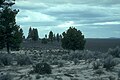
The Oregon high desert is a region of the U.S. state of Oregon located east of the Cascade Range and south of the Blue Mountains, in the central and eastern parts of the state. Divided into a southern region and a northern region, the desert covers most of five Oregon counties and averages 4,000 feet (1,200 m) above sea level. The southwest region is part of the Great Basin and the southeast is the lower Owyhee River watershed. The northern region is part of the Columbia Plateau, where higher levels of rainfall allow the largest industry on private land to be the cultivation of alfalfa and hay. Public land within the region is owned primarily by the Bureau of Land Management, which manages more than 30,000 square miles (78,000 km2) including five rivers designated as Wild and Scenic.

Eastern Cascades Slopes and Foothills Temperate coniferous forests ecoregion of the United States

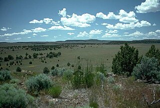
The Eastern Cascades Slopes and Foothills ecoregion is a Level III ecoregion designated by the United States Environmental Protection Agency (EPA) in the U.S. states of Oregon, Washington, and California. In the rain shadow of the Cascade Range, the eastern side of the mountains experiences greater temperature extremes and receives less precipitation than the west side. Open forests of ponderosa pine and some lodgepole pine distinguish this region from the Cascades ecoregion, where hemlock and fir forests are more common, and from the lower, drier ecoregions to the east, where shrubs and grasslands are predominant. The vegetation is adapted to the prevailing dry, continental climate and frequent wildfire. Volcanic cones and buttes are common in much of the region.

Blue Mountains (ecoregion) Temperate coniferous forests ecoregion of the United States

The Blue Mountains ecoregion is a Level III ecoregion designated by the United States Environmental Protection Agency (EPA) in the Pacific Northwest, mainly in the state of Oregon, with small areas over the state border in Idaho and southeastern Washington. It is also contiguous with the World Wildlife Fund's Blue Mountain forests ecoregion.

Columbia Plateau (ecoregion) Xeric shrubland ecoregion.of Canada and the United States

The Columbia Plateau ecoregion is a Level III ecoregion designated by the United States Environmental Protection Agency (EPA) encompassing approximately 32,100 square miles (83,139 km2) of land within the U.S. states of Washington, Oregon, and Idaho. The ecoregion extends across a wide swath of the Columbia River Basin from The Dalles, Oregon to Lewiston, Idaho to Okanogan, Washington near the Canada–US border. It includes nearly 500 miles (800 km) of the Columbia River, as well as the lower reaches of major tributaries such as the Snake and Yakima rivers and the associated drainage basins. It is named for the Columbia River Plateau, a flood basalt plateau formed by the Columbia River Basalt Group during the late Miocene and early Pliocene. The arid sagebrush steppe and grasslands of the region are flanked by moister, predominantly forested, mountainous ecoregions on all sides. The underlying basalt is up to 2 miles (3 km) thick and partially covered by thick loess deposits. Where precipitation amounts are sufficient, the deep loess soils have been extensively cultivated for wheat. Water from the Columbia River is subject to resource allocation debates involving fisheries, navigation, hydropower, recreation, and irrigation, and the Columbia Basin Project has dramatically converted much of the region to agricultural use.

Northern Basin and Range ecoregion

The Northern Basin and Range ecoregion is a Level III ecoregion designated by the United States Environmental Protection Agency (EPA) in the U.S. states of Oregon, Idaho, Nevada, Utah, and California. It contains dissected lava plains, rolling hills, alluvial fans, valleys, and scattered mountain ranges in the northern part of the Great Basin. Although arid, the ecoregion is higher and cooler than the Snake River Plain to the north and has more available moisture and a cooler climate than the Central Basin and Range to the south. Its southern boundary is determined by the highest shoreline of Pleistocene Lake Bonneville, which once inundated the Central Basin and Range. The western part of the region is internally drained; its eastern stream network drains to the Snake River system.

Christmas Valley Sand Dunes Natural sand dune complex in Lake County, Oregon, United States

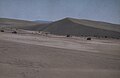
The Christmas Valley Sand Dunes are a natural sand dune complex covering 11,000 acres (45 km2) of public lands east of Christmas Valley in Lake County, Oregon, United States, about 100 miles (160 km) southeast of Bend. The area is accessible via the Christmas Valley National Back Country Byway. The dunes are up to 60 feet (18 m) high. It is the largest inland shifting sand dune system in the Pacific Northwest. The dunes are composed mostly of ash and pumice from the eruption of Mount Mazama that formed Crater Lake 7,000 years ago. Approximately 8,900 acres (36 km2) of dunes are open to vehicles.

Oregon Badlands Wilderness

The Oregon Badlands Wilderness is a 29,301-acre (11,858 ha) wilderness area located east of Bend in Deschutes and Crook counties in the U.S. state of Oregon. The wilderness is managed by the Bureau of Land Management as part of the National Landscape Conservation System and was created by the Omnibus Public Land Management Act of 2009, which was signed into law by President Barack Obama on 30 March 2009.

Warner Valley Valley in south-central Oregon

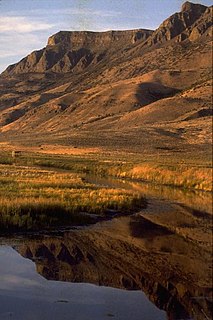
The Warner Valley is a valley in south-central Oregon in the United States. It is a remote valley at the northwestern corner of North America's Basin and Range Province. The valley is home to a chain of lakes and wetlands known as the Warner Lakes. Native Americans were present in the Warner Valley for thousands of years before European explorers arrived in the 19th century. It is the site of Fort Warner, built by the United States Army in 1867. The fort was used as a supply depot and administrative headquarters during a protracted Army campaign against Northern Paiute bands in eastern Oregon and northern California. Today, livestock ranching is the main commercial activity in the valley. The Warner Valley offers a number of recreational opportunities including hunting, fishing, bird watching, and wildlife viewing.

Goose Lake Valley Valley in south-central Oregon and northeastern California

The Goose Lake Valley is located in south-central Oregon and northeastern California in the United States. It is a high valley at the northwestern corner of North America's Great Basin. Much of the valley floor is covered by Goose Lake, a large endorheic lake that straddles the Oregon–California border. Native Americans inhabited the Goose Lake Valley for thousands of years before explorers arrived in the 19th century. The pioneer wagon route known as the Applegate Trail crossed the Goose Lake Valley on its way to southern Oregon. At the south end of Goose Lake, the Lassen Cutoff separated from the Applegate Trail and headed south toward the Sacramento Valley. Today, Lakeview, Oregon, is the largest settlement in the valley. Livestock ranching and lumber mills are the valley's main commercial activity. The Goose Lake Valley offers a number of recreational opportunities including hang-gliding, hunting, fishing, and birdwatching.

Agriculture in the Southwest United States is very important economically in that region.

Derrick Cave

Derrick Cave is a lava tube located in the remote northwest corner of Lake County, Oregon. The cave is approximately 1,200 feet (370 m) long. It is up to 80 feet (24 m) wide and 46 feet (14 m) high in places. It was named in honor of H.E. Derrick, a pioneer rancher with a homestead 3 miles (4.8 km) southeast of the cave. The land around the cave is managed by the United States Department of Interior, Bureau of Land Management. Derrick Cave is open to the public year-round; however, camping is no longer permitted in the cave.

Catlow Valley

The Catlow Valley is a basin in Harney County, Oregon, United States. It is a remote valley at the northwestern corner of North America's Basin and Range Province. The valley is named after a pioneer rancher, John Catlow. The area was used by Native Americans for thousands of years before European explorers arrived in the 19th century. Today, cattle ranching is the main commercial activity in the valley. The public land in the Catlow Valley is administered by the Bureau of Land Management. This public land offers a number of recreational opportunities including hiking, hunting, fishing, bird watching, and wildlife viewing.

Fossil Lake (Oregon)

Fossil Lake is a dry lakebed in the remote high desert country of northern Lake County in the U.S. state of Oregon. During the Pleistocene epoch, Fossil Lake and the surrounding basin were covered by an ancient lake. Numerous animals used the lake resources. Over time, the remains of many of these animals became fossilized in the lake sediments. As a result, Fossil Lake has been an important site for fossil collection and scientific study for well over a century. Over the years, paleontologists have found the fossil remains of numerous mammals as well as bird and fish species there. Some of these fossils are 2 million years old.

Gerber Reservoir Reservoir in Oregon, USA

Gerber Reservoir is an irrigation impoundment created by Gerber Dam. It is located in southern Klamath County, Oregon, United States. The reservoir covers 3,815 acres (1,544 ha). The dam and reservoir are named in honor of Louis C. Gerber, an early pioneer who owned much of the land flooded by the reservoir. Today, the reservoir and surrounding property is owned by the United States Government. It is administered by the Bureau of Reclamation and the Bureau of Land Management. Gerber Reservoir is a popular outdoor recreation site with two campgrounds along its west shore.

The flora of the Colorado Plateau and Canyonlands region of the Western United States.

Burma Rim Geological formation in Oregon

Burma Rim is a geological feature in the high desert of Lake County, Oregon between Christmas Valley, Oregon to the west and Wagontire, Oregon to the east. The rim was formed when it was the shoreline of a pleistocene era lake. The area is currently overseen by the Lakeview District of the Bureau of Land Management (BLM). The BLM inventoried the area. It spans 90,397 acres and includes a private inholding held by a local conservation group since 2017.

References

  1. "Lost Forest Research Natural Area". Geographic Names Information System . United States Geological Survey . Retrieved 2009-05-31.
  2. 1 2 3 4 5 6 7 8 9 10 11 12 13 14 Moir, William H., Jerry F. Franklin, and Chris Maser, Lost Forest Research Natural Area, Pacific Northwest Forest and Range Experiment Station, United States Forest Service, Department of Agriculture, Portland, Oregon, 1973.
  3. 1 2 "Lost Forest Research Natural Area" Archived 2011-07-21 at the Wayback Machine , Research Natural Areas, Lakeview District, Bureau of Land Management, United States Department of Interior, Lakeview, Oregon, 24 May 2009.
  4. 1 2 3 4 5 Chadwick, Kristen L. and Andris Eglitis, Health Assessment of the Lost Forest Research Natural Area, Central Oregon Service Center for Insects and Diseases, United States Forest Service, United States Department of Agriculture, Bend, Oregon, February 2007.
  5. 1 2 Lost Forest Research Natural Area, Christmas Valley Sand Dunes Area of Critical Environmental Concern, Lakeview District, Bureau of Land Management, United States Department of Interior, Lakeview, Oregon, 2005.
  6. 1 2 "The Lost Forest, OR", Outback Scenic Byway, National Scenic Byway Program, United States Department of Transportation, Washington, D.C., 2009.
  7. 1 2 Jackman, E.R. and R.A. Long, The Oregon Desert, Caxton Press, Caldwell, Idaho, 1964 (Fourteenth printing May 2003), pp. 364-365.
  8. Morehouse, Kenyon, "Camp Abbot", video interview for Oregon at War, part of the Oregon Experience series, Oregon Public Broadcasting (in cooperation with the Oregon Historical Society), Portland Oregon, 2007.
  9. Senate Bill 449 Archived 2011-06-11 at the Wayback Machine , 75th Oregon Legislative Assembly, Salem, Oregon, 2009.