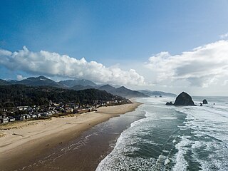
Cannon Beach is a city in Clatsop County, Oregon, United States. Its population was 1,690 at the 2010 census. It is a popular coastal Oregon tourist destination, famous for Haystack Rock, a 235 ft (72 m) sea stack that juts out along the coast. In 2013, National Geographic listed it as "one of the world's 100 most beautiful places."

The Oregon Coast Trail (OCT) is a long-distance hiking route along the Pacific coast of the U.S. state of Oregon in the United States. It follows the coast of Oregon from the mouth of the Columbia River to the California border south of Brookings.

The Lewis and Clark National Historical Park, located in the vicinity of the mouth of the Columbia River, commemorates the Lewis and Clark Expedition. Administration of the park, which includes both federal and state lands, is a cooperative effort of the National Park Service and the states of Oregon and Washington. The National Historical Park was dedicated on November 12, 2004.
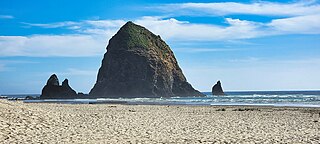
Haystack Rock is a 235 ft-tall (72 m) sea stack in Cannon Beach, Oregon. It is the third-tallest such intertidal structure in the world. A popular tourist destination on the Oregon Coast, the monolithic rock is adjacent to the beach and accessible by foot at low tide. The Haystack Rock tide pools are home to many intertidal animals, including starfish, sea anemone, crabs, chitons, limpets, and sea slugs. The rock is also a nesting site for many sea birds, including terns and puffins.

Rooster Rock State Park is a state park located east of Corbett, in the U.S. state of Oregon. One of the features of the park is Rooster Rock, a column of basalt forming a natural obelisk, which stands near the south side of the Columbia River Gorge, in the lee of Crown Point. The park is administered by the Oregon Parks and Recreation Department.
Cape Lookout State Park is a state park on Cape Lookout in the U.S. state of Oregon. It is located in Tillamook County, south of the city of Tillamook, on a sand spit between Netarts Bay and the Pacific Ocean.

Oswald West State Park is part of the state park system of the U.S. state of Oregon. It is located about 10 miles (16 km) south of the city of Cannon Beach, adjacent to Arch Cape, on the Pacific Ocean. The park covers 2,448 acres (9.91 km2), with many miles of hiking trails both inside the park grounds and linking to other parks and landmarks beyond.
Trail of Tears State Park is a public recreation area covering 3,415 acres (1,382 ha) bordering the Mississippi River in Cape Girardeau County, Missouri. The state park stands as a memorial to those Cherokee Native Americans who died on the Cherokee Trail of Tears. The park's interpretive center features exhibits about the Trail of Tears as well as displays and specimens of local wildlife. An archaeological site in the park was added to the National Register of Historic Places in 1970.
Arcadia Beach State Recreation Site is a beach and state park on the Oregon Coast of the United States located two miles south of Cannon Beach. Under the right conditions, one may hear the "singing sands" a squeaking or violin-like noise.

The Yachats State Recreation Area is a state park in southern Lincoln County, Oregon, in the central district of the town of Yachats. It is administered by the Oregon Parks and Recreation Department. It is located on the Pacific Ocean coast, on the north side of the mouth of the Yachats River. The park is open for day use only, and offers wildlife and surf viewing, tidepools, fishing, and picnicking.

Oregon Islands National Wildlife Refuge is a U.S. National Wildlife Refuge off the southwestern Oregon Coast. It is one of six National Wildlife Refuges comprising the Oregon Coast National Wildlife Refuge Complex. The Oregon Islands provides wilderness protection to 1,853 small islands, rocks, and reefs plus two headlands, totaling 371 acres (150 ha) spanning 1,083 acres (438 ha) of Oregon's coastline from the Oregon–California border to Tillamook Head. There are sites in six of the seven coastal counties of Oregon. From north to south they are Clatsop, Tillamook, Lincoln, Lane, Coos, and Curry counties. The area is managed by the United States Fish and Wildlife Service.

Erratic Rock State Natural Site is a state park in the Willamette Valley of Oregon, United States. Featuring a 40-short-ton (36 t) glacial erratic from the Missoula Floods, the small park sits atop a foothill of the Northern Oregon Coast Range in Yamhill County between Sheridan and McMinnville off Oregon Route 18. The day use only park is owned and maintained by the Oregon Parks and Recreation Department.

Hug Point State Recreation Site is a state park on the northern Oregon Coast in the U.S. state of Oregon. Administered by the Oregon Parks and Recreation Department, the park is open to the public and is fee-free. Amenities at the park, which is 5 miles (8.0 km) south of Cannon Beach along U.S. Route 101, include picnicking, fishing, and a Pacific Ocean beach.

Gleneden Beach State Recreation Site is a state park administered by the Oregon Parks and Recreation Department in the U.S. state of Oregon. Located along the Pacific Ocean 7 miles (11 km) south of Lincoln City, it offers public beach access, picnicking, and fishing in a setting of shore pines, sandstone bluffs, and sand. The park is fee-free.

Oceanside Beach State Recreation Site is a state park in the U.S. state of Oregon. Administered by the Oregon Parks and Recreation Department, the park is open to the public and is fee-free. Amenities at the site, in the unincorporated community of Oceanside, include picnicking, wildlife watching, fishing, windsurfing, and kite flying. It is not uncommon to see paraglider pilots land at the beach on Southwest wind days during the fall, winter and spring. Beachcombing is popular in summer, and agate hunting is best in winter, when ocean currents remove sand. Oceanside is about 11 miles (18 km) west of Tillamook off U.S. Route 101.

Arch Cape is an unincorporated community in Clatsop County, Oregon, United States. Named for the natural arch in the coastal rocks and the headland (cape) that extends into the Pacific Ocean, it is located along the Pacific coast, approximately four miles south of Cannon Beach, between Hug Point State Recreation Site to the north and Oswald West State Park to the south.

Camp Meriwether is a 790-acre Scouts BSA summer camp founded in 1926 and located south of Cape Lookout near Cloverdale, Oregon, along the Oregon Coast. Camp Meriwether is the largest of the Cascade Pacific Council's four resident camps in Oregon. During World War II, the camp was closed for two years and served as a US Army outpost until 1943. Since 2015, there has been controversy over the intended development of a golf course over 200 acres of coastal land.

Hager Mountain is a volcanic peak in Oregon in the northwest corner of the Basin and Range Province in the United States. The mountain is located south of the small unincorporated community of Silver Lake in south-central Oregon, and it is in the Fremont–Winema National Forest. On the summit, there is a fire lookout operated during the summer and fall by the United States Forest Service. There are several hiking trails that lead to the lookout station.

Brian Booth State Park is a coastal recreational area located near Seal Rock, Lincoln County, Oregon United States, administered by the Oregon Parks and Recreation Department. It consists of two major portions: Ona Beach State Park and Beaver Creek State Natural Area, which were merged in 2013. The park has beach access, kayaking, and hiking trails. The park is 886.32 acres and has an annual attendance of 247,772 people. Ona is known as a Chinook Jargon word for razor clam.

Many coastal peninsulas of Oregon are properly headlands, often called capes.


 The cape from the beach in Pacific City, November 2004
 View from the trail on Cape Kiwanda
 Haystack Rock near Cape Kiwanda
 Aerial View of Cape Kiwanda State Natural Area

