
Monmouth County is a county located on the northern part of the Jersey Shore in the U.S. state of New Jersey. The county is part of the New York metropolitan area. As of the 2020 United States census, the county was the state's fifth-most-populous county with a population of 643,615, its highest decennial count ever and an increase of 13,235 (+2.1%) from the 2010 census count of 630,380, which in turn reflected an increase of 15,079 from 615,301 at the 2000 census. As of 2010, the county fell to the fifth-most populous county in the state, having been surpassed by Hudson County. Monmouth County's geographic area comprises 30% water.

Freehold is a borough and the county seat of Monmouth County, in the U.S. state of New Jersey. Known for its Victorian era homes and extensive colonial history, the borough is located in the Raritan Valley region within the New York Metropolitan Area, located about 33 miles (53 km) from Manhattan and 17 miles (27 km) from Staten Island. The borough has grown to become a commuter town of New York City. As of the 2020 United States census, the borough's population was 12,538, its highest decennial count ever and an increase of 486 (+4.0%) from the 12,052 recorded at the 2010 census, which in turn had reflected an increase of 1,076 (+9.8%) from the 10,976 counted at the 2000 census.

Freehold Township is a township in western Monmouth County, in the U.S. state of New Jersey. Located in Central New Jersey and crisscrossed by several major highways, the township is known for being the regional commercial hub for Monmouth County and as a suburban bedroom community of New York City, located within the Raritan Valley region of the much larger New York Metropolitan Area. The township is located roughly 38 miles (61 km) away from Manhattan and about 20 miles (32 km) away from Staten Island. As of the 2020 United States census, the township's population was 35,369, a decrease of 815 (−2.3%) from the 36,184 recorded at the 2010 census, which in turn had reflected an increase of 4,647 (+14.7%) from the 31,537 counted at the 2000 census.

Marlboro Township is a township in Monmouth County, in the U.S. state of New Jersey. The township is located within the Raritan Valley region and is a part of the New York Metropolitan Area. As of the 2020 United States census, the township's population was 41,502, an increase of 1,311 (+3.3%) from the 2010 census count of 40,191, which in turn reflected an increase of 5,449 (+16.3%) from the 33,423 counted in the 2000 census.

Route 79 is a state highway located in Monmouth County in the U.S. state of New Jersey. It runs 12.13 mi (19.52 km) from an intersection with U.S. Route 9 in Freehold Township north to an intersection with Route 34 and County Route 516 Spur in Matawan. The route is a mostly two-lane undivided road that passes through a mixture of suburban residential, urban commercial, and open rural areas. The route intersects Route 33 in Freehold Township, Route 33 Business and CR 537 in Freehold Borough, Route 18 and CR 520 in Marlboro Township, and CR 516 in Matawan.
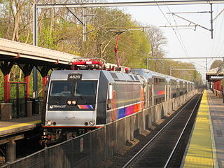
The North Jersey Coast Line is a commuter rail line running from Rahway to Bay Head, New Jersey, traversing through the Jersey Shore region. Operated by New Jersey Transit, the line is electrified as far south as Long Branch. On rail system maps it is colored light blue, and its symbol is a sailboat. The line runs along the former New York & Long Branch Railroad, which was co-owned by the Central Railroad of New Jersey and the Pennsylvania Railroad.

The Henry Hudson Trail is a rail trail in western and northern Monmouth County, New Jersey. The trail is named for Henry Hudson, who explored the harbor at Atlantic Highlands and the Raritan Bayshore coastline in the early 1600s. The trail is not near the Hudson River.
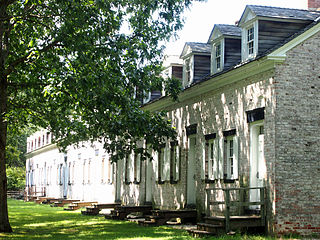
Allaire Village is a living history museum located within New Jersey's Allaire State Park in Wall Township, Monmouth County, New Jersey. The property was initially an Indian ceremonial ground prior to 1650, by 1750 a sawmill had been established on the property by Issac Palmer. The village was later established as a bog iron furnace originally known as Williamsburg Forge 'Monmouth Furnace' was then renamed the Howell Works by Benjamin B. Howell. In 1822, it was then purchased by philanthropist James P. Allaire, who endeavoured to turn into a self-contained community. The wood burning furnace business collapsed in 1846 and the village closed. During its height, the town supported about 500 people. Following his death, the property passed through a number of family members before being used by the Boy Scouts who started to restore the buildings for use as a summer camp. Losing the lease, the property then passed to the State of New Jersey. Allaire Village and its existing buildings are now operated by a non-profit organization - Allaire Village, Inc. Historic interpreters work using period tools and equipment in the blacksmith, tinsmith, and carpentry shops, while the old bakery sells cookies, and general store serves as a museum gift-shop styled store. The church building is frequently used for weddings. The site is also host to community events such as community band concerts, antique sales, weekly flea markets and square dance competitions.
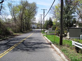
Wickatunk is an unincorporated community located within Marlboro Township in Monmouth County, in the U.S. state of New Jersey. Elevation above sea level is 180 feet (55 m). It was founded in 1695 by three Scottish servants from the community of Toponemus. Originally surveyed by George Keith, in a letter he states:
"After some time I may give thee a particular account of all thy land I have surveyed for thee and what I reckon dew for it. John Laing and his family are well and lyke to do well, and so John Sym and his family. Also thou hast thy share laid out at Wickington (Wickatunk).
The Freehold and Jamesburg Agricultural Railroad was a short-line railroad in New Jersey. The railroad traversed through the communities of Freehold Borough, Freehold Township, Manalapan Township, Englishtown Borough, Monroe Township, and Jamesburg Borough, en route to Monmouth Junction in South Brunswick Township. Its former right-of-way, along with a portion of the Farmingdale and Squan Village Railroad's right-of-way, has become the Edgar Felix Bikeway and the Freehold right-of-way between Route 537 and Big Brook Park in Marlboro Township has become the Henry Hudson Trail. The section of right of way from Route 537 parallel to Jackson Street and behind the former Karagheusian Rug Mill to the former Central Railroad of New Jersey depot on Jackson Street at Mechanic Street in Freehold Borough has not as of yet been improved to be part of the trail. It is not clear whether this part of the right of way is still owned by New Jersey Transit which owns the rest of the line north into Matawan. The latter has been ‘railbanked’ which means it can be reactivated
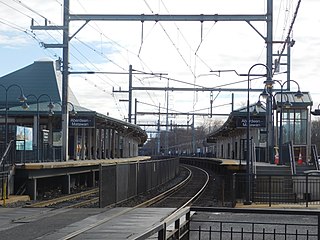
Aberdeen–Matawan is a station on NJ Transit's North Jersey Coast Line, located in Aberdeen and Matawan, Monmouth County, New Jersey, United States. This station, convenient to Route 35 and the PNC Bank Arts Center, is popular with both commuters and concertgoers, and is the busiest station on the line between Bay Head and Rahway.

Elmer Hendrickson Geran was an American Democratic Party politician who represented New Jersey's 3rd congressional district from 1923 to 1925.
Marlboro Psychiatric Hospital was a public hospital in Marlboro Township, Monmouth County, New Jersey, United States, which was operated by the State of New Jersey. Construction of the hospital began in 1929. It first opened in early 1931, with Dr. J.B. Gordon as medical director. According to the site plan, the hospital's campus was on 468 acres (189 ha). A perimeter fence completely enclosed the property. The land was mostly a rural environment. When it closed, the hospital was on 594 acres (240 ha), having enlarged the grounds over the years. It opened with a capacity to accommodate 500-800 patients. The grounds construction continued after opening and when completed, the hospital was expected to have a capacity of 2,000 patients. However, in 1995, the hospital served an average of 780 adults per day with a staff of 1,157 employees and a total budget of $55.5 million. The budget in 1998 was $68 million. The facility was closed July 1, 1998. The hospital finished complete demolition of the structures, tunnels, roads and other infrastructure in early 2015.

Scobeyville is an unincorporated community located within Colts Neck Township in Monmouth County, in the U.S. state of New Jersey. The settlement is named for the Scobey family which has inhabited the township since the 1700s. The site housed a one-room schoolhouse, a post office, and a general store. It was known for good fishing on the Yellow Brook which has its basin in Scobyville.

Pleasant Valley is an unincorporated community located within Marlboro Township in Monmouth County, in the U.S. state of New Jersey. The area reportedly received its name from George Washington after he went through the area in 1777. The area is hilly and forested and is dotted by medium to large-sized residences. Pleasant Valley Road and Reids Hill Road are main roads that pass through the area connecting to Routes 34, 79, and 520. A large part of land which makes up Pleasant Valley was originally granted by the King of England in 1665 to the Rev. Obadiah Holmes. In 1690, the area was settled by people of Dutch heritage and the original dominant language in the area was Low Dutch.
Marlboro Township, New Jersey has a number of historic sites. The Monmouth County Historic Site Inventory (HSI) was started in 1980 by the directors of both the Monmouth County Historical Association and the Monmouth County Park System. This inventory project provided an inventory number to all historic properties in Monmouth County, New Jersey. In addition to property details, this listing provides reference numbers for easy identification. In addition to the park system inventory, the Marlboro Township Historic Commission provides a listing of Historic Commission Landmarks (HCL). These are physical signs placed in historically significant locations. There was also a list presented by the NJ Department of Environmental Protection - Historic Preservation Office (HPO).

The Old Scots Burying Ground is a historic cemetery located on Gordon's Corner Road in the Wickatunk section of Marlboro Township, in Monmouth County, New Jersey. It was added to the National Register of Historic Places on August 15, 2001, for its significance in history and religion. The Old Scots Burying Ground is about an acre in size, about 195 feet above sea level and dates back to 1685. The total number of burials at the cemetery is not precisely known, suggested by Symms, "There are a large number of graves in Old Scots yard without any inscribed stones". Some reports place the number as at least 100 known graves with most headstones of brown sandstone. However, more recent research using ground penetrating radar reported by the Old Tennent Church in 2001 has put the number of confirmed sites at about 122 graves with a possible 140 more unmarked; placing the number at about 262 total graves in the cemetery. In 1945, in an attempt to clean out the site of vegetation and over-growth, a bulldozer was used on the property and as a result some headstones were dislodged and broken stones removed. The defining structure in the cemetery is a tall monument to Rev. John Boyd, created by the J&R Lamb Company. Built to commemorate the first recorded Presbyterian ordination of Rev. John Boyd. The monument is currently owned by the Synod of the Northeast who holds the property deed but it is maintained by the Old Tennent Church. The last identified burial was in 1977.
The Devitte Military Academy was an American military academy founded in 1918 by Major Leopold Devitte and Suzanne Jacques DeVitte. It started as the "Devitte School" but changed its name in 1927. It closed in 1979.
Asher Holmes was an American politician and veteran of the American Revolution.


