Marlboro is an unincorporated community located within Marlboro Township in Monmouth County, New Jersey, United States.

Locust is an unincorporated community located within Middletown Township in Monmouth County, New Jersey, United States. It is situated along the north banks of the Navesink River and Claypit Creek. The area consists of mostly medium-to-large sized houses throughout the hilly terrain of this part of the township. The Oceanic Bridge connects Locust with Rumson to the south.
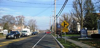
Beacon Hill is an unincorporated community located within Marlboro Township in Monmouth County, New Jersey, United States. The community is named for a nearby hill, in-turn named because it was a lookout point towards the Raritan Bay and beacons on the hill were used to warn residents of impending British troops in the American Revolutionary War. Located on the north face of the hill are housing developments and Marlboro Memorial Middle School. East of the summit, New Jersey Route 34 runs through the area through a commercial zone.

Applegarth is an unincorporated community located within Monroe Township in Middlesex County, New Jersey, United States. The settlement is located in the southern portion of the township and is traversed by the road of the same name, Applegarth Road. At the location of the original settlement, at the intersection of Applegarth, Wycoffs Mills, and Old Church Roads, there is a restaurant, farmland, and the Applegarth Fire Department. Further north along Applegarth Road are housing developments, age-restricted communities, and two elementary schools: Applegarth and Oak Tree.

Prospertown is an unincorporated community located within the New Jersey townships of Jackson and Plumsted in Ocean County and Upper Freehold in Monmouth County. The community is home to Prospertown Lake and is adjacent to Six Flags Great Adventure, both located on County Route 537. The center of the community is located at the intersection of CR 537, Hawkin Road, and Emleys Hill Road. Most of the area consists of pine forests but there are some homes along the roads in the area.
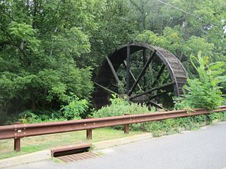
Bucks Mill is an unincorporated community located within Colts Neck Township, in Monmouth County, New Jersey, United States. Bucks Mill Road is the main road that passes north and south through the area; County Route 537 travels to the south of Bucks Mill, near the Hominy Hill Golf Course. Homes, equestrian facility and horse farms, and the township-owned Bucks Mill Recreational Area are located in the area. The settlement is named for Bucks Mill, a gristmill that derived its power from a watermill on the Yellow Brook. Originally built in 1854 and owned for many years by William Buck, Alfred Buck, and Garrett Buck, it was destroyed by a fire on October 30, 1967. The watermill is the only remaining artifact of the original complex and stands today on the side of Bucks Mill Road.

Harneys Corner is an unincorporated community located within Lawrence Township in Mercer County, New Jersey, United States. It is located at the intersection of Lawrence Road and Princeton Pike / Avenue. Located in the southern portion of the township close to the Trenton and Ewing borders, the area consists of small houses on nearby side streets and businesses along the aforementioned arterial roads. The intersection itself is located about 0.3 miles (0.48 km) north of the Brunswick Circle.
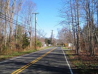
Millstone is an unincorporated community located within East Windsor Township in Mercer County, New Jersey, United States. Located in the northern portion of the township near Old Cranbury Road, U.S. Route 130, and New Jersey Route 133, it is a planned community constructed in the 1960s.

Rileyville is an unincorporated community located within East Amwell Township in Hunterdon County, New Jersey, United States. Located on the ridge line of Sourland Mountain, it is located along Rileyville Road near its intersections with Ridge Road and Mountain Road. Most of the area is forested though some single-family houses are located along the aforementioned roads, and some farmland sits on the north face of the mountain.

Fresh Ponds is an unincorporated community located within South Brunswick Township in Middlesex County, New Jersey, United States. It is located in a rural portion of the township at the intersection of Fresh Ponds Road and Davidson Mill Road. Forest land, farms, homes, and a church are located around the settlement.

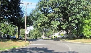
Middlesex Downs is an unincorporated community located within Monroe Township in Middlesex County, New Jersey, United States. The wholly residential settlement contains small homes along Dey Grove Road and Bergen Mills Road with larger homes in developments towards the south. The township-owned James Monroe Memorial Park is also located in this settlement. Much of the area to the north of Dey Grove Road consists of forest land but at one time this was planned to become a large planned community arranged in a street grid. The small property parcels and paper streets remain on township tax maps today.
Tracy is an unincorporated community located within Monroe Township in Middlesex County, New Jersey, United States. The settlement is located at the site of a former station on the Freehold and Jamesburg Agricultural Railroad in the southeastern edge of the township. Most of the area is forestland with some homes and light commercial businesses located along Federal Road and Tracy Station Road.

Union Valley is an unincorporated community located within Monroe Township in Middlesex County, New Jersey, United States. Two large age-restricted communities lie within the settlement today, Clearbrook Park and Concordia. Other than those two communities, the only other buildings in the area are medical offices and facilities and some single-family homes along Union Valley Road.
Wyckoffs Mills is an unincorporated community located along the border of Cranbury and Monroe townships in Middlesex County, New Jersey, United States. Located at the intersection of Wyckoff Mills Road and Wyckoffs Mills Road, the area only contains lots containing residential structures; the remainder of the land is made up of farmland and wetlands. The Millstone River flows to the south of the settlement and a 500-kilovolt transmission line crosses the farmland to the north and south.

Cooleys Corner is an unincorporated community located within Upper Freehold Township in Monmouth County, New Jersey, United States. The site of the settlement is within the Assunpink Wildlife Management Area, a New Jersey Department of Environmental Protection Division of Fish and Wildlife-operated preserved area in Monmouth and Mercer counties along the Assunpink Creek. Before the creation of the Assunpink Lake in the 1970s, the area consisted of farmland located at the intersection of Clarksburg Road and Imlaystown-Hightstown Road. Some farmland is still present in the area but is now mostly used by hunters. The main boat ramp to Assunpink Lake is located along the former Imlaystown-Hightstown Road.

Freewood Acres is an unincorporated community located within Howell Township in Monmouth County, New Jersey, United States. The area is made up of mostly single-story homes arranged along a street grid in the northern reaches of the Pine Barrens. U.S. Route 9 runs through the center of the community just north of its interchange with Interstate 195. The Land O'Pines Elementary School and Manasquan Reservoir County Park exist to the east of the community. It became the center of the Kalmyk American community in the latter part of the 20th century.

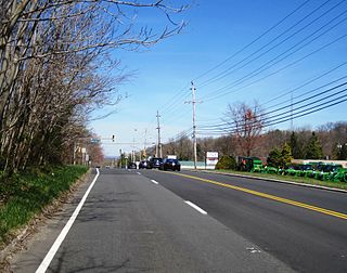
Freneau is an unincorporated community located within Matawan in Monmouth County, New Jersey, United States. It is named for Philip Freneau (1752–1832), a poet during the American Revolutionary War. The community is located along New Jersey Route 79 in the southern portion of Matawan and was formerly served by the Monmouth County Agricultural Railroad.

Oceanic is an unincorporated community located within Rumson in Monmouth County, New Jersey, United States. Located on the north side of the borough, Oceanic contains most of Rumson's commercial businesses mainly along Bingham Avenue and River Road. Bingham Avenue connects directly to the Oceanic Bridge over the Navesink River to the Middletown Township community of Locust Point.

Old Church is an unincorporated community located within Monroe Township in Middlesex County, New Jersey, United States. The settlement is named for a Presbyterian community that settled on the site but relocated to Cranbury c. 1740. Originally, the area was farmland. One of the farms in the area was the Dey Farm, in existence since the founding of Monroe Township in 1838 and the site of a command post used by George Washington during the Battle of Monmouth in 1778. Starting in 2004, the area experienced a major change from its agricultural roots to single-family residences on the south side of the area and age-restricted communities to the north. This redevelopment also caused the severing of the main north–south road, Old Church Road and the extension of Federal Road which formerly had its western end at Old Church Road to Applegarth Road. The a farmhouse named England House was moved 4,000 feet (1,200 m) to the Dey Farm site to preserve the area's history prior to the construction of the new houses in 2004.

Ellisdale is an unincorporated community located along the border of North Hanover Township in Burlington County and Upper Freehold Township in Monmouth County, in New Jersey, United States. The community is centered about the intersection of Province Line Road and Hill Road / Ellisdale-Crosswicks Road. The Crosswicks Creek runs to the north of the settlement and the nearby Ellisdale Fossil Site takes its name from Ellisdale.


