
Moorestown-Lenola is an unincorporated community and census-designated place (CDP) located within Moorestown Township in Burlington County, in the U.S. state of New Jersey. As of the 2010 United States Census, the CDP's population was 14,217.

Ashland is an unincorporated community and census-designated place (CDP) located within Cherry Hill, in Camden County, in the U.S. state of New Jersey. As of the 2010 United States Census, the CDP's population was 8,302.

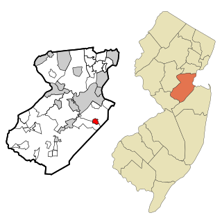
Golden Triangle is an unincorporated community and census-designated place (CDP) located within Cherry Hill, in Camden County, in the U.S. state of New Jersey. As of the 2010 United States Census, the CDP's population was 4,145.
Brownville is an unincorporated community and census-designated place (CDP) located within Old Bridge Township, in Middlesex County, in the U.S. state of New Jersey. As of the 2010 United States Census, the CDP's population was 2,383.

Concordia is an unincorporated community and census-designated place (CDP) located within Monroe Township, in Middlesex County, in the U.S. state of New Jersey. The CDP is oriented around the age restricted gated community of Concordia. As of the 2010 United States Census, the CDP's population was 3,092.

Heathcote is an unincorporated community and census-designated place (CDP) located within South Brunswick, in Middlesex County, in the U.S. state of New Jersey. As of the 2010 United States Census, the CDP's population was 5,821.

Old Bridge is a census-designated place (CDP) located in Old Bridge Township, in Middlesex County, in the U.S. state of New Jersey. As of the 2010 United States Census, the CDP's population was 23,753. Despite the similarity in the name of the CDP and the township, the two are not one and the same, as had been the case for most paired Township / CDP combinations prior to the 2010 Census, in which the CDP was coextensive with a township of the same name.

Princeton Meadows is an unincorporated community and census-designated place (CDP) located within Plainsboro Township, in Middlesex County, in the U.S. state of New Jersey. As of the 2010 United States Census, the CDP's population was 13,834.

Society Hill is an unincorporated community and census-designated place (CDP) located within Piscataway Township, in Middlesex County, in the U.S. state of New Jersey. As of the 2010 United States Census, the CDP's population was 3,829.

Whittingham, also known as Greenbriar at Whittingham, is an unincorporated community and census-designated place (CDP) located within Monroe Township, in Middlesex County, in the U.S. state of New Jersey. As of the 2010 United States Census, the CDP's population was 2,476. The area is focused around the age-restricted gated community of Whittingham.

Woodbridge is an unincorporated community and census-designated place (CDP) within Woodbridge Township, in Middlesex County, in the U.S. state of New Jersey. As of the 2010 United States Census, the CDP's population was 19,265. Despite the similarity in the name of the CDP and the township, the two are not coextensive; the CDP occupies 15.7% of the township's 24.51 square miles (63.5 km2).

East Freehold is an unincorporated community and census-designated place (CDP) located within Freehold Township, in Monmouth County, in the U.S. state of New Jersey. As of the 2010 United States Census, the CDP's population was 4,894.

Allenwood is an unincorporated community and census-designated place (CDP) located within Wall Township, in Monmouth County, in the U.S. state of New Jersey. As of the 2010 United States Census, the CDP's population was 925.

Strathmore is an unincorporated community and census-designated place (CDP) within Aberdeen Township, in Monmouth County, in the U.S. state of New Jersey. At the 2010 census, the CDP's population was 7,258.

Lake Telemark is an unincorporated community and census-designated place (CDP) located within Rockaway Township, in Morris County, in the U.S. state of New Jersey. As of the 2010 United States Census, the CDP's population was 1,255.

Barnegat is an unincorporated community and census-designated place (CDP) located within Barnegat Township, in Ocean County, in the U.S. state of New Jersey. As of the 2010 United States census, the CDP's population was 2,817.

Holiday Heights is an unincorporated community and census-designated place (CDP) located within Berkeley Township, in Ocean County, in the U.S. state of New Jersey. As of the 2010 United States Census, the CDP's population was 2,099.

Silver Ridge is an unincorporated community and census-designated place (CDP) located within Berkeley Township, in Ocean County, in the U.S. state of New Jersey. As of the 2010 United States Census, the CDP's population was 1,133.

Lakewood is an unincorporated community and census-designated place (CDP) located within Lakewood Township, in Ocean County, in the U.S. state of New Jersey. As of the 2010 United States Census, the CDP's population was 53,805.

Clearbrook is a gated community and census-designated place (CDP) located in Monroe Township, Middlesex County, in the U.S. state of New Jersey. It is in the western part of the township, bordered to the north by Encore at Monroe and to the east by Concordia and The Ponds. It is 3.5 miles (5.6 km) southwest of Jamesburg and 5 miles (8 km) northeast of Hightstown.


