Route 18 is a 42.8-mile-long (68.9 km) state highway in the central part of the US state of New Jersey. It begins at an intersection with Route 138 in Wall Township, Monmouth County and ends at Interstate 287 (I-287) in Piscataway Township, Middlesex County. Route 18 is a major route through central New Jersey that connects the Jersey Shore to the Raritan Valley region, connecting the county seats of Monmouth (Freehold) and Middlesex respectively. The route runs through Ocean Township, Marlboro Township, and East Brunswick, as for much of the route is a freeway. The remainder of the route is an expressway with traffic lights in the East Brunswick and Old Bridge areas, and a boulevard in the remainder of Piscataway. Route 18 was designated in 1939 as a proposed freeway from Old Bridge to Eatontown. The section west of Old Bridge was formerly designated as part Route S28, a prefixed spur of State Highway Route 28 from Middlesex to Matawan. The designation, assigned in the 1927 renumbering, remained until a second renumbering in 1953. At that point, Route S28 was redesignated as Route 18, though the section from Old Bridge to Matawan was signed as TEMP 18, as this section would be decommissioned when the Route 18 freeway was built.

Route 34 is a state highway in the central part of the U.S. state of New Jersey. The route runs 26.79 mi (43.11 km) from an intersection with Route 35 and Route 70 in Wall Township, Monmouth County, north to an intersection with U.S. Route 9 in Old Bridge Township, Middlesex County. The route is a four-lane divided highway between its southern terminus and the north end of the Route 33 concurrency in Howell Township; along this stretch, the route intersects the Garden State Parkway and Interstate 195 (I-195)/Route 138 within a short distance of each other. North of Route 33, Route 34 is an undivided two- to four-lane road that intersects Route 18 in Colts Neck Township and Route 79 in Matawan. Route 34 passes through mostly suburban areas along its route.

Route 38 is a state highway in the southern part of the U.S. state of New Jersey serving the Philadelphia metropolitan area. It extends 19.19 mi (30.88 km) from the Airport Circle, where it intersects U.S. Route 30 and US 130, in Pennsauken Township, Camden County, east to an intersection with US 206 and CR 530 in Southampton Township, Burlington County. The entire route is closely parallel to CR 537 located to the north, being only one block away at places. The route is a multilane divided highway for most of its length and passes through commercial development, residential development, and some farmland.
Colts Neck Township is a township in Monmouth County, in the U.S. state of New Jersey. It is located in the New York Metropolitan Area. As of the 2020 United States census, the township's population was 9,957, a decrease of 185 (−1.8%) from the 2010 census count of 10,142, which in turn reflected a decline of 2,189 (−17.8%) from the 12,331 counted in the 2000 census.

Freehold Township is a township in western Monmouth County, in the U.S. state of New Jersey. Located in Central New Jersey and crisscrossed by several major highways, the township is known for being the regional commercial hub for Monmouth County and as a suburban bedroom community of New York City, located within the Raritan Valley region of the much larger New York Metropolitan Area. The township is located roughly 38 miles (61 km) away from Manhattan and about 20 miles (32 km) away from Staten Island. As of the 2020 United States census, the township's population was 35,369, a decrease of 815 (−2.3%) from the 36,184 recorded at the 2010 census, which in turn had reflected an increase of 4,647 (+14.7%) from the 31,537 counted at the 2000 census.
Howell Township is a township in Monmouth County, in the U.S. state of New Jersey. The township is the largest municipality in the county by total area, comprised of about 61.21 square miles (158.5 km2). It is located in the New York metropolitan area and has been a steadily growing bedroom community of New York City. As of the 2020 United States census, the township's population was 53,537, its highest decennial count ever and an increase of 2,462 (+4.8%) from the 2010 census count of 51,075, which in turn reflected an increase of 2,172 (+4.4%) from the 48,903 counted in the 2000 census.

Wall Township is a township within Monmouth County, in the U.S. state of New Jersey. Crisscrossed by several different highways within the heart of the Jersey Shore region, the township is a transportation hub of Central New Jersey and a bedroom suburb of New York City, in the New York Metropolitan Area. As of the 2020 United States census, Wall Township's population was 26,525, its highest decennial count ever and an increase of 361 (+1.4%) from the 2010 census count of 26,164, which in turn reflected an increase of 903 (+3.6%) from the 25,261 counted in the 2000 census.

County Route 537 is a county highway in the U.S. state of New Jersey. The highway extends 66.22 miles (106.57 km) from Delaware Avenue in Camden to CR 11 in Oceanport. It is the state's fourth longest 500 series county route.

Adelphia is an unincorporated community located in northern Howell Township, Monmouth County, in the U.S. state of New Jersey. The area is served as United States Postal Service ZIP code 07710. The community borders Freehold Township, and residents who reside in Adelphia use a Freehold mailing address.

County Route 520 is a county highway in the U.S. state of New Jersey. County Route 520 is a major road across Monmouth County connecting the county's central towns to the Jersey Shore at Sea Bright. The highway extends 22.39 miles (36.03 km) from Englishtown Road in Old Bridge Township to Ocean Avenue in Sea Bright.

Phalanx is an unincorporated community located within Colts Neck Township in Monmouth County, in the U.S. state of New Jersey. It is located near the Swimming River Reservoir and is across from Brookdale Community College in Lincroft. The community is named for the North American Phalanx, a communal agricultural community that existed in the 19th century. The community disbanded in 1854 following a fire but the main residence stood until November 14, 1972 when another fire destroyed it. Homes began to replace the former farmland beginning in the late 1970s and is now the primary composition of the area.

Jerseyville is an unincorporated community located within Howell Township in Monmouth County, in the U.S. state of New Jersey. It is primarily a rural area within the northern part of the township, near Colts Neck and Freehold. Route 33 Business travels through Jerseyville, with some development, including a gas station, a convenience store, a church, and several residences.

Scobeyville is an unincorporated community located within Colts Neck Township in Monmouth County, in the U.S. state of New Jersey. The settlement is named for the Scobey family which has inhabited the township since the 1700s. The site housed a one-room schoolhouse, a post office, and a general store. It was known for good fishing on the Yellow Brook which has its basin in Scobyville.
Montrose is an unincorporated community located near the intersection of Dutch Lane Road and Boundary Road along the border of Colts Neck and Marlboro townships in Monmouth County, in the U.S. state of New Jersey. The town was located in "Atlantic Township" at one time prior to the name being changed to "Colts Neck". Prior to being called Montrose, the area was called "Barrentown".

Burlington Heights is an unincorporated community located within Freehold Township in Monmouth County, in the U.S. state of New Jersey. The community was created in the early 1960s and originally consisted of 112 homes of mixed styles designed by Peter Petillo and Associates of Freehold. It is located along Colts Neck Road on the east side of the township, near New Jersey Route 18 and the Colts Neck municipal line.

Charleston Springs is an unincorporated community located within Millstone Township in Monmouth County, in the U.S. state of New Jersey. Stage Coach Road, also designated County Route 524, is the main road that runs through the settlement, with Ely Harmony Road as the intersecting road defining the locality. The Manalapan Brook runs to the west of the center of Charleston Springs and CR 537 runs to the south of the area. The Monmouth County-owned Charleston Springs Golf Course is located one mile (1.6 km) northeast of the center of Charleston Springs on CR 527.

Ely is an unincorporated community located within Millstone Township in Monmouth County, in the U.S. state of New Jersey. The settlement is named for the Ely family that owned property in the area and operated the Charleston Springs hotel. Today, the settlement is located along Stage Coach Road, County Route 524, in the eastern portion of the township. Most of the area consists of large single-family homes though some farmland and the township-owned Brandywine Soccer Complex are located in the near the settlement.
Hillsdale is an unincorporated community located within Colts Neck and Marlboro townships in Monmouth County, in the U.S. state of New Jersey. The community is located at the intersection of County Route 520 which runs east and west, Conover Road which heads north, and Boundary Road which heads south. The southeastern quadrant of this intersection is a part of Colts Neck while the other three are in Marlboro. The community is located atop a small hill and is largely rural. The Colts Neck quadrant is made up of a housing development while the Marlboro side is mostly forests, parkland, and the remains of the Marlboro Psychiatric Hospital.

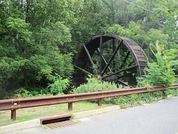
Lower Squankum is an unincorporated community located within Howell Township in Monmouth County, in the U.S. state of New Jersey. The settlement is located along Lakewood-Farmingdale Road at its intersection with Herbertsville Road and Old Tavern Road in the eastern side of the township. It is also located near the boundary of Allaire State Park and is south of Interstate 195's exit 31. Nearby the community are the remains of the Lower Squankum Mill and the Lower Squankum Friends Burial Site, located within the median of CR 547 at the aforementioned interchange.

Old Church is an unincorporated community located within Monroe Township in Middlesex County, New Jersey, United States. The settlement is named for a Presbyterian community that settled on the site but relocated to Cranbury c. 1740. Originally, the area was farmland. One of the farms in the area was the Dey Farm, in existence since the founding of Monroe Township in 1838 and the site of a command post used by George Washington during the Battle of Monmouth in 1778. Starting in 2004, the area experienced a major change from its agricultural roots to single-family residences on the south side of the area and age-restricted communities to the north. This redevelopment also caused the severing of the main north–south road, Old Church Road and the extension of Federal Road which formerly had its western end at Old Church Road to Applegarth Road. The a farmhouse named England House was moved 4,000 feet (1,200 m) to the Dey Farm site to preserve the area's history prior to the construction of the new houses in 2004.