Yorketown, New Jersey

Last updated
Yorketown, New Jersey
Yorketown, NJ.jpg
Yorketown Center shopping plaza
Monmouth County New Jersey Incorporated and Unincorporated areas Yorketown Highlighted.svg
Map of Yorketown highlighted within Monmouth County. Right: Location of Monmouth County in New Jersey.
Coordinates: 40°18′21″N74°20′20″W / 40.305904°N 74.338899°W / 40.305904; -74.338899 Coordinates: 40°18′21″N74°20′20″W / 40.305904°N 74.338899°W / 40.305904; -74.338899
Country Flag of the United States.svg  United States
State Flag of New Jersey.svg  New Jersey
County Monmouth
Township Manalapan
Area
[1]
  Total2.40 sq mi (6.21 km2)
  Land2.39 sq mi (6.18 km2)
  Water0.01 sq mi (0.02 km2)  0.39%
Elevation
[2]
95 ft (29 m)
Population
 (2020) [3]
  Total6,617
  Density2,770.94/sq mi (1,069.96/km2)
Time zone UTC-5 (Eastern (EST))
  Summer (DST) UTC-4 (Eastern (EDT))
Area code(s) 732/848
FIPS code 3483245 [4]
GNIS feature ID02390550 [5]

Yorketown is an unincorporated community and census-designated place (CDP) within Manalapan Township, in Monmouth County, New Jersey, United States. [6] [7] At the 2020 census, the CDP's population was 6,739. [8]

Contents

Geography

According to the United States Census Bureau, Yorketown had a total area of 2.397 square miles (6.210 km2), including 2.388 square miles (6.186 km2) of land and 0.009 square miles (0.024 km2) of water (0.39%). [9] [10]

Demographics

Historical population
CensusPop.Note
1990 6,313
2000 6,7126.3%
2010 6,535−2.6%
2020 6,7393.1%
Population sources:
1990-2010 [6] 2000 [11] 2010 [8] [3]

Census 2010

The 2010 United States census counted 6,535 people, 1,976 households, and 1,769 families in the CDP. The population density was 2,736.3 per square mile (1,056.5/km2). There were 2,014 housing units at an average density of 843.3 per square mile (325.6/km2). The racial makeup was 93.66% (6,121) White, 1.78% (116) Black or African American, 0.06% (4) Native American, 3.00% (196) Asian, 0.02% (1) Pacific Islander, 0.55% (36) from other races, and 0.93% (61) from two or more races. Hispanic or Latino of any race were 5.39% (352) of the population. [8]

Of the 1,976 households, 47.4% had children under the age of 18; 78.4% were married couples living together; 8.1% had a female householder with no husband present and 10.5% were non-families. Of all households, 9.1% were made up of individuals and 3.6% had someone living alone who was 65 years of age or older. The average household size was 3.24 and the average family size was 3.46. [8]

27.6% of the population were under the age of 18, 7.9% from 18 to 24, 22.3% from 25 to 44, 31.7% from 45 to 64, and 10.4% who were 65 years of age or older. The median age was 40.2 years. For every 100 females, the population had 95.6 males. For every 100 females ages 18 and older there were 93.9 males. [8]

Census 2000

At the 2000 census [4] there were 6,712 people, 1,950 households, and 1,790 families living in the CDP. The population density was 1,079.8/km2 (2,791.5/mi2). There were 1,967 housing units at an average density of 316.4/km2 (818.1/mi2). The racial makeup of the CDP was 93.79% White, 2.22% African American, 0.04% Native American, 2.53% Asian, 0.04% Pacific Islander, 0.33% from other races, and 1.04% from two or more races. Hispanic or Latino of any race were 3.52% of the population. [11]

Of the 1,950 households 53.4% had children under the age of 18 living with them, 82.4% were married couples living together, 7.1% had a female householder with no husband present, and 8.2% were non-families. 6.7% of households were one person and 2.1% were one person aged 65 or older. The average household size was 3.40 and the average family size was 3.56. [11]

The age distribution was 31.3% under the age of 18, 6.2% from 18 to 24, 29.1% from 25 to 44, 25.5% from 45 to 64, and 7.8% 65 or older. The median age was 37 years. For every 100 females, there were 95.2 males. For every 100 females age 18 and over, there were 93.9 males. [11]

The median household income was $89,351 and the median family income was $95,430. Males had a median income of $70,789 versus $42,295 for females. The per capita income for the CDP was $31,132. About 2.0% of families and 2.7% of the population were below the poverty line, including 3.9% of those under age 18 and 8.2% of those age 65 or over. [11]

Related Research Articles

<span class="mw-page-title-main">Moorestown-Lenola, New Jersey</span> Census-designated place in New Jersey, United States

Moorestown-Lenola is an unincorporated community and census-designated place (CDP) located within Moorestown Township in Burlington County, New Jersey, United States. As of the 2010 United States Census, the CDP's population was 14,217.

<span class="mw-page-title-main">Ramblewood, New Jersey</span> Census-designated place in New Jersey, United States

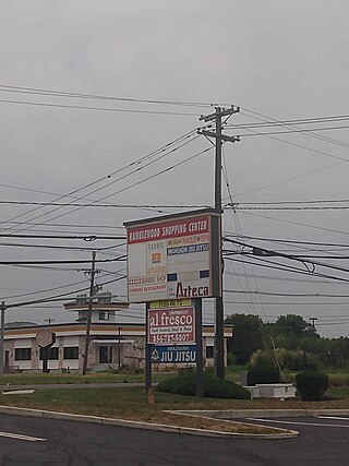
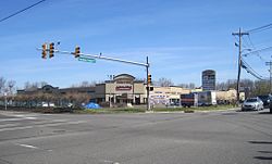
Ramblewood is an unincorporated community and census-designated place (CDP) located within Mount Laurel Township in Burlington County, New Jersey, United States. As of the 2010 United States Census, the CDP's population was 5,907.

<span class="mw-page-title-main">Greentree, New Jersey</span> Census-designated place in New Jersey, United States

Greentree is an unincorporated community and census-designated place (CDP) located within Cherry Hill Township, in Camden County, New Jersey, United States. As of the 2010 United States Census, the CDP's population was 11,367.

<span class="mw-page-title-main">Cedarville, New Jersey</span> Census-designated place in New Jersey

Cedarville is an unincorporated community and census-designated place (CDP) located within Lawrence Township, in Cumberland County, New Jersey, United States. It is part of the Vineland-Millville-Bridgeton Primary Metropolitan Statistical Area for statistical purposes. As of the 2020 United States Census, the CDP's population was 702.

<span class="mw-page-title-main">Turnersville, New Jersey</span> Populated place in Gloucester County, New Jersey, US

Turnersville is an unincorporated community and census-designated place (CDP) located within Washington Township, in Gloucester County, New Jersey, United States. As of the 2010 United States Census, the CDP's population was 3,742.

<span class="mw-page-title-main">Cranbury (CDP), New Jersey</span> Census-designated place in New Jersey, United States

Cranbury is an unincorporated community and census-designated place (CDP) located within Cranbury Township, in Middlesex County, New Jersey, United States. As of the 2010 United States Census, the CDP's population was 2,181. Despite the similarity in the name of Cranbury Township and the CDP, the two are not one and the same, as had been the case for most paired Township / CDP combinations prior to the 2010 Census, in which the CDP was coextensive with a township of the same name.

<span class="mw-page-title-main">Fords, New Jersey</span> Census-designated place in New Jersey, United States

Fords is an unincorporated community and census-designated place (CDP) located within Woodbridge Township, in Middlesex County, New Jersey, United States. As of the 2010 United States Census, the CDP's population was 15,187.

<span class="mw-page-title-main">Old Bridge (CDP), New Jersey</span> Census-designated place in New Jersey, United States

Old Bridge is a census-designated place (CDP) in Old Bridge Township, in Middlesex County, New Jersey, United States. As of the 2010 United States Census, the CDP's population was 23,753. Despite the similarity in the name of the CDP and the township, the two are not one and the same, as had been the case for most paired Township / CDP combinations prior to the 2010 Census, in which the CDP was coextensive with a township of the same name.

<span class="mw-page-title-main">Society Hill, Middlesex County, New Jersey</span> Populated place in Middlesex County, New Jersey, US

Society Hill is an unincorporated community and census-designated place (CDP) located within Piscataway Township, in Middlesex County, in the U.S. state of New Jersey. As of the 2010 United States Census, the CDP's population was 3,829.

<span class="mw-page-title-main">Fairview, Monmouth County, New Jersey</span> Census-designated place in New Jersey, United States

Fairview is an unincorporated community and census-designated place (CDP) located within Middletown Township, in Monmouth County, New Jersey, United States. As of the 2010 United States Census, the CDP's population was 3,806.

<span class="mw-page-title-main">Lincroft, New Jersey</span> Populated place in Monmouth County, New Jersey, US

Lincroft is an unincorporated community and census-designated place (CDP) within Middletown Township, in Monmouth County, in the U.S. state of New Jersey. As of the 2020 United States Census, the CDP had a population of 7,060, teflecting a 15.1% increase from the 6,135 residents enumerated at the 2010 U.S. Census, in turn a decline of 120 residents (-1.9%) from the 6,255 counted at the 2000 U.S. Census.

<span class="mw-page-title-main">North Middletown, New Jersey</span> Census-designated place in New Jersey, United States

North Middletown is an unincorporated community and census-designated place (CDP) within Middletown Township, in Monmouth County, New Jersey, United States. As of the 2010 United States Census, the CDP's population was 3,295.

<span class="mw-page-title-main">West Belmar, New Jersey</span> Census-designated place in New Jersey, United States

West Belmar is an unincorporated community and census-designated place (CDP) within Wall Township, in Monmouth County, New Jersey, United States. At the 2010 census, the CDP's population was 2,493.

<span class="mw-page-title-main">Belford, New Jersey</span> Populated place in Monmouth County, New Jersey, US

Belford is an unincorporated community and census-designated place (CDP) located within Middletown Township, in Monmouth County, in the U.S. state of New Jersey. As of the 2010 United States census, the CDP's population was 1,768.

<span class="mw-page-title-main">Strathmore, New Jersey</span> Census-designated place in New Jersey, United States

Strathmore is an unincorporated community and census-designated place (CDP) within Aberdeen Township, in Monmouth County, New Jersey, United States. At the 2010 census, the CDP's population was 7,258.

<span class="mw-page-title-main">Leisure Village, New Jersey</span> Census-designated place in New Jersey, United States

Leisure Village is an unincorporated community and census-designated place (CDP) located within Lakewood Township, in Ocean County, New Jersey, United States. As of the 2010 United States Census, the CDP's population was 4,400. The sprawling active adult community is also locally known as "Original" Leisure Village because it was the first of three neighboring active adult communities bearing similar names. Leisure Village East, and Leisure Village West are the other two communities nearby. Original Leisure Village (OLV) is also referred to by the moniker "The Village of Seven Lakes."

<span class="mw-page-title-main">Vista Center, New Jersey</span> Census-designated place in New Jersey, United States

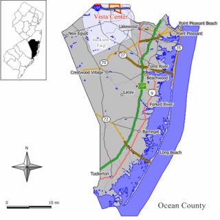
Vista Center is an unincorporated community and census-designated place (CDP) located within Jackson Township in Ocean County, New Jersey, United States. As of the 2010 United States Census, the CDP's population was 3,689.

<span class="mw-page-title-main">Crandon Lakes, New Jersey</span> Census-designated place in New Jersey, United States

Crandon Lakes is an unincorporated community and census-designated place (CDP) split between Hampton Township and Stillwater Township, in Sussex County, New Jersey, United States. As of the 2010 United States Census, the CDP's population was 1,178, of which 682 were in Hampton Township and 496 in Stillwater Township.

<span class="mw-page-title-main">Brass Castle, New Jersey</span> Census-designated place in New Jersey, United States

Brass Castle is an unincorporated community and census-designated place (CDP) located within Washington Township, in Warren County, New Jersey, United States. As of the 2010 United States Census, the CDP's population was 1,555.

<span class="mw-page-title-main">Carneys Point (CDP), New Jersey</span> Census-designated place in New Jersey, United States

Carneys Point is an unincorporated community and census-designated place (CDP) located within Carneys Point Township, in Salem County, New Jersey, United States. As of the 2010 United States Census, the CDP's population was 7,382.

References

  1. "ArcGIS REST Services Directory". United States Census Bureau. Retrieved October 11, 2022.
  2. U.S. Geological Survey Geographic Names Information System: Yorketown Census Designated Place, Geographic Names Information System. Accessed August 7, 2012.
  3. 1 2 "Census Population API". United States Census Bureau. Retrieved Oct 11, 2022.
  4. 1 2 U.S. Census website, United States Census Bureau. Accessed September 4, 2014.
  5. US Board on Geographic Names, United States Geological Survey. Accessed September 4, 2014.
  6. 1 2 New Jersey: 2010 - Population and Housing Unit Counts - 2010 Census of Population and Housing (CPH-2-32), United States Census Bureau, August 2012. Accessed December 14, 2012.
  7. GCT-PH1 - Population, Housing Units, Area, and Density: 2010 - County -- County Subdivision and Place from the 2010 Census Summary File 1 for Monmouth County, New Jersey Archived 2020-02-12 at archive.today , United States Census Bureau. Accessed December 14, 2012.
  8. 1 2 3 4 5 DP-1 - Profile of General Population and Housing Characteristics: 2010 Demographic Profile Data for Yorketown CDP, New Jersey Archived 2020-02-12 at archive.today , United States Census Bureau. Accessed August 7, 2012.
  9. Gazetteer of New Jersey Places, United States Census Bureau. Accessed July 20, 2016.
  10. US Gazetteer files: 2010, 2000, and 1990, United States Census Bureau. Accessed September 4, 2014.
  11. 1 2 3 4 5 DP-1 - Profile of General Demographic Characteristics: 2000 from the Census 2000 Summary File 1 (SF 1) 100-Percent Data for Yorketown CDP, New Jersey Archived 2020-02-12 at archive.today , United States Census Bureau. Accessed December 14, 2012.