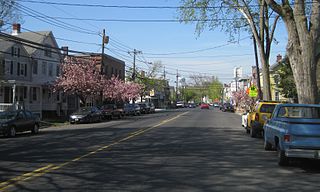
Allentown is a borough in Monmouth County, New Jersey, United States. As of the 2010 United States Census, the borough's population was 1,828, reflecting a decline of 54 (-2.9%) from the 1,882 counted in the 2000 Census, which had in turn increased by 54 (+3.0%) from the 1,828 counted in the 1990 Census.

Millstone Township is a township in Monmouth County, New Jersey, United States. It is located within the Raritan Valley region and is a part of the New York Metropolitan Area. The township was named for the Millstone River, whose name derives from an incident in which a millstone was dropped into it. The headwaters for the Millstone River originate in the township.
Upper Freehold Township is a township in Monmouth County, New Jersey, United States. As of the 2010 United States Census, the township's population was 6,902, reflecting an increase of 2,620 (+61.2%) from the 4,282 counted in the 2000 Census, which had in turn increased by 1,005 (+30.7%) from the 3,277 counted in the 1990 Census.
County Route 539 is a county highway in the U.S. state of New Jersey. The highway extends 54.32 miles (87.42 km) from Main Street in Tuckerton to CR 535 in Cranbury Township. Much of the two-lane route passes through isolated areas of the Pine Barrens and the eastern end of the Fort Dix entity of Joint Base McGuire–Dix–Lakehurst. In these stretches, the route has a speed limit of 55 miles per hour (89 km/h), one of the few two-lane roads in the state to carry a 55 mph limit. CR 539 passes through three boroughs: Tuckerton, Allentown, and Hightstown. Other than those boroughs, the route travels mainly through rural townships.
County Route 524 is a county highway in the U.S. state of New Jersey. The highway extends 39.90 miles (64.21 km) from the White Horse Circle in Hamilton Township to Route 71 in Spring Lake Heights.
The Millstone Township Schools are a community public school district that serves students in pre-kindergarten through eighth grade from Millstone Township, in Monmouth County, New Jersey, United States.
Smithburg is an unincorporated community located where the municipal boundaries of Freehold, Manalapan and Millstone townships intersect in Monmouth County, New Jersey, United States. County Route 527 and Monmouth Road pass through the center of the quaint village of Smithburg.

Hornerstown is an unincorporated community located within Upper Freehold Township in Monmouth County, New Jersey, United States. Hornerstown is located near Cream Ridge and uses the 08514 ZIP code.

Prospertown is an unincorporated community located within the New Jersey townships of Jackson and Plumsted in Ocean County and Upper Freehold in Monmouth County. The community is home to Prospertown Lake and is adjacent to Six Flags Great Adventure, both located on County Route 537. The center of the community is located at the intersection of CR 537, Hawkin Road, and Emleys Hill Road. Most of the area consists of pine forests but there are some homes along the roads in the area.

New Canton is an unincorporated community located along the border of Robbinsville Township in Mercer County and Upper Freehold Township in Monmouth County, New Jersey, United States. The area was once known as Cabbagetown and has been settled since the 18th century. The settlement is located at the intersection of Old York Road and New Canton-Stone Tavern Road just north of Interstate 195's interchange 8. The Upper Freehold side of the area contains farmland and new housing developments while the Robbinsville side features new commercial warehouse buildings including an Amazon.com Fulfillment Center opened in July 2014.

New Sharon is an unincorporated community located along the border of Robbinsville Township in Mercer County and Upper Freehold Township in Monmouth County, New Jersey, United States. Old York Road passes through the center of the community.

Emleys Hill is an unincorporated community located within Upper Freehold Township in Monmouth County, New Jersey, United States. The settlement is located at the intersection of Emleys Hill Road and Burlington Path Road.

Cooleys Corner is an unincorporated community located within Upper Freehold Township in Monmouth County, New Jersey, United States. The site of the settlement is within the Assunpink Wildlife Management Area, a New Jersey Department of Environmental Protection Division of Fish and Wildlife-operated preserved area in Monmouth and Mercer counties along the Assunpink Creek. Before the creation of the Assunpink Lake in the 1970s, the area consisted of farmland located at the intersection of Clarksburg Road and Imlaystown-Hightstown Road. Some farmland is still present in the area but is now mostly used by hunters. The main boat ramp to Assunpink Lake is located along the former Imlaystown-Hightstown Road.

Ely is an unincorporated community located within Millstone Township in Monmouth County, New Jersey, United States. The settlement is named for the Ely family that owned property in the area and operated the Charleston Springs hotel. Today, the settlement is located along Stage Coach Road, County Route 524, in the eastern portion of the township. Most of the area consists of large single-family homes though some farmland and the township-owned Brandywine Soccer Complex are located in the near the settlement.

Fairfield is an unincorporated community located within Howell Township in Monmouth County, New Jersey, United States. The community is centered on the intersection of County Route 524 (CR 524) and Ketchum Road, where the Colonial Era Our House Tavern is located. The area includes several small businesses, township offices and schools. There are also small farms and residential developments in the area. Fairfield was a stop on the Freehold and Jamesburg Agricultural Railroad

Kirbys Mills is an unincorporated community located within Upper Freehold Township in Monmouth County, New Jersey, United States. Centered near the intersection of Burlington Path Road and Holmes Mill Road, the area consists of housing developments and small farms.

Sharon is an unincorporated community located within Upper Freehold Township in Monmouth County, New Jersey, United States. Located at the intersection of Herbert Road and Sharon Station Road, the settlement is the site of a former stop on the Pemberton and Hightstown Railroad. Except for a few single-family homes in the area, most of the area is farmland. The railroad has since been abandoned and is being converted to the Union Transportation Trail, a rail trail. Sharon is the current northern terminus of the trail.

Shrewsbury is an unincorporated community located within Upper Freehold Township in Monmouth County, New Jersey, United States. The settlement is located along County Route 524 at what was once a grade crossing with the Pemberton and Hightstown Railroad with an associated rail station. Since the removal of the railroad, the right-of-way has become a part of the Union Transportation Trail. Besides the trail, the area is made up of mostly farmland with some agricultural-related businesses and single-family homes nearby.

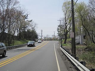
Spring Mill is an unincorporated community located within Upper Freehold Township in Monmouth County, New Jersey, United States. The settlement is located along County Route 524 between Hamilton Township and Allentown on a commercialized segment of the road originally built as New Jersey Route 37. A vestige of the state construction remains along the road through a wide right-of-way and a bridge crossing Doctor's Creek stating that it was constructed by the state in 1940 for State Highway Route 37.

Ellisdale is an unincorporated community located along the border of North Hanover Township in Burlington County and Upper Freehold Township in Monmouth County, in New Jersey, United States. The community is centered about the intersection of Province Line Road and Hill Road / Ellisdale-Crosswicks Road. The Crosswicks Creek runs to the north of the settlement and the nearby Ellisdale Fossil Site takes its name from Ellisdale.


