
Roding Valley is a London Underground station situated in Buckhurst Hill in the Epping Forest district of Essex, straddling the boundary between that council and Greater London. The station is on the Hainault loop of the Central line between Chigwell and Woodford stations. However, geographically it is midway between Woodford and Buckhurst Hill stations. It is located between Station Way and Cherry Tree Rise. Since 2 January 2007, the station has been in Travelcard Zone 4.
Hainault is a large suburban housing estate in the London Borough of Redbridge. It is located 12.5 miles (20.1 km) northeast of Charing Cross. Most of the housing in Hainault was built by the London County Council between 1947 and 1953. Originally spanning the parishes of Chigwell, Dagenham and Ilford, in 1965 the area was combined in a single London borough and became part of Greater London.

Loughton is a town and civil parish in the Epping Forest District of Essex. Part of the metropolitan and urban area of London, the town borders Chingford, Waltham Abbey, Theydon Bois, Chigwell and Buckhurst Hill, and is 12 miles (19 km) northeast of Charing Cross.
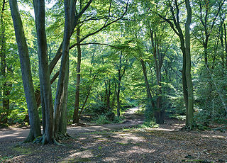
Epping Forest is a 2,400-hectare (5,900-acre) area of ancient woodland, and other established habitats, which straddles the border between Greater London and Essex. The main body of the forest stretches from Epping in the north, to Chingford on the edge of the London built-up area. South of Chingford the forest narrows, and forms a green corridor that extends deep into East London, as far as Forest Gate; the Forest's position gives rise to its nickname, the Cockney Paradise. It is the largest forest in London.

Woodford Green is an area of Woodford in East London, England, within the London Borough of Redbridge. It adjoins Buckhurst Hill to the north, Woodford Bridge to the east, South Woodford to the south, and Chingford to the west. Epping Forest runs through Woodford Green in the west of the area, 9.4 miles (15.1 km) north-east of Charing Cross.

Chigwell is a town and civil parish in the Epping Forest District of Essex, England. It is part of the urban and metropolitan area of London, and is adjacent to the northern boundary of Greater London. It is on the Central line of the London Underground.
Epping Forest District is a local government district in Essex, England. It is named after the ancient woodland of Epping Forest, a large part of which lies within the district. The council is based in the town of Epping. The district also includes the towns of Loughton, Ongar and Waltham Abbey and surrounding rural areas. The district is situated in the west of the county, bordering the north-eastern edge of London.

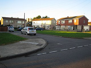
Buckhurst Hill is a suburban town in the Epping Forest district of Essex, England. It is part of the Greater London Urban Area and adjacent to the northern boundary of the London Borough of Redbridge. The area developed following the opening of a railway line in 1856, originally part of the Eastern Counties Railway and now on the Central line of the London Underground.

Epping Forest is a constituency represented in the House of Commons of the UK Parliament since 1997 by Eleanor Laing, a Conservative.
Dagenham was a local government district in south west Essex, England from 1926 to 1965 covering the parish of Dagenham. Initially created as an urban district, it was incorporated as a municipal borough in 1938. It was established to deal with the increase in population and the change from rural to urban area caused by the building of the Becontree estate by the London County Council and the subsequent movement of people from Inner London. Peripheral to London, the district formed part of the Metropolitan Police District and London Traffic Area. It now forms the eastern sections of the London Borough of Barking and Dagenham and the London Borough of Redbridge in Greater London.
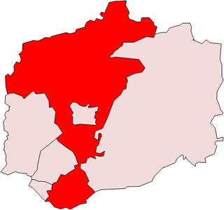
The district of Epping Forest is in the county of Essex in England. It was created on 1 April 1974, following the merger of Epping Urban District, Chigwell Urban District, Waltham Holy Cross Urban District, and part of Epping and Ongar Rural District.
Epping was a parliamentary constituency represented in the House of Commons of the UK Parliament from 1885 to 1974. It elected one Member of Parliament (MP) by the first past the post system of election.

The A104 is an A road which runs from Islington Green in London to Epping in Essex, England.
Epping was, from 1894 to 1955, a rural district in the administrative county of Essex, England.

London Buses route 167 is a Transport for London contracted bus route in London, England. Running between Ilford and Loughton station, it is operated by Stagecoach London.

Woodford is a town in East London, within the London Borough of Redbridge. It is located 9.5 miles (15.3 km) north-east of Charing Cross. Woodford historically formed an ancient parish in the county of Essex. It contained a string of agrarian villages and was part of Epping Forest. From about 1700 onwards, it became a place of residence for affluent people who had business in London; this wealth, together with its elevated position, has led to it being called the Geographical and social high point of East London. Woodford was suburban to London and after being combined with Wanstead in 1934 it was incorporated as a municipal borough in 1937. It has formed part of Greater London since 1965 and comprises the neighbourhoods of Woodford Green, Woodford Bridge, Woodford Wells and South Woodford. The area is served by two stations on the Central line of the London Underground: Woodford and South Woodford.
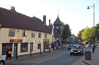
Loughton is a town in the county of Essex in England. The first settlement can be traced back to 2,500 years ago, but the earliest records of the modern-day site of Loughton are from the Anglo-Saxon era of English history, when it was known as Lukintone. After the Norman conquest it became part of the estate of Waltham Abbey and is mentioned in the Domesday Book as Lochintuna. It was during the 17th century, however, when Loughton began to grow significantly as a coaching stop on the newly created main route to Cambridge and East Anglia. With good transport links and proximity to both London and also Epping Forest and the countryside, it became a popular location for aristocratic and wealthy Londoners to have a home.
Loughton in Essex, England, was an urban district from 1900-1933, when it became part of Chigwell Urban District until 1974, when Epping Forest District Council was created. Loughton Town Council was established in 1996. The Town Council consists of 22 Councillors representing seven wards, elected for a four-year term. The council adopted the designation Town Council just after its re-creation as a parish in 1996, and changed the title of its chairman to Town Mayor in 2004.
Debden is a suburb in the civil parish of Loughton, in the Epping Forest district of Essex, England. It takes its name from the ancient manor of Debden, which lay at its northern end. The area is predominantly residential, but is also the location of Epping Forest College, East 15 Acting School and the De La Rue printing works. It is one of a limited number of places outside Greater London to be served by the London Underground.
Waltham Abbey is a civil parish in Epping Forest District in Essex, England. Located approximately 14 miles (23 km) north-northeast of central London and adjacent to the Greater London boundary, it is a partly urbanised parish with large sections of open land in the Metropolitan Green Belt. Waltham Abbey is a recent renaming of the ancient parish of Waltham Holy Cross. Aside from the town of Waltham Abbey which contains the majority of the population, it includes the hamlets of Claverhambury, Fishers Green, Holyfield, Sewardstone and Upshire, and the village of High Beach. The local council is Waltham Abbey Town Council.


