Related Research Articles

Chislehurst is a suburban district of south-east London, England, in the London Borough of Bromley. It lies east of Bromley, south-west of Sidcup and north-west of Orpington, 10 miles (16 km) south-east of Charing Cross. Before the creation of Greater London in 1965, it was in Kent.
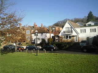
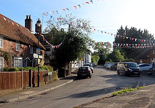
Pratt's Bottom is a village in Greater London, England, within the London Borough of Bromley and, prior to 1965, within the historic county of Kent. It is south of its parent parish of Orpington, lies about 100 metres above sea level and beyond London's urban sprawl.
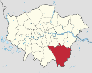
The London Borough of Bromley is the southeasternmost of the London boroughs that make up Greater London, bordering the ceremonial county of Kent, which most of Bromley was part of before 1965. The borough's population is an estimated 332,336. It is named after Bromley, its principal town; other major towns are Penge, Hayes, West Wickham, Chislehurst, Beckenham and Orpington. The local authority is Bromley London Borough Council.

Bexley is an area of south-eastern Greater London, England and part of the London Borough of Bexley. It is sometimes known as Bexley Village or Old Bexley to differentiate the area from the wider borough. It is located 13 miles (21 km) east-southeast of Charing Cross and south of Bexleyheath.
Chislehurst and Sidcup Urban District was a local government district and civil parish in north west Kent, England from 1934 to 1965.
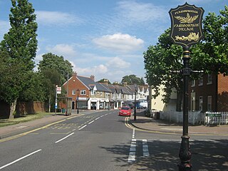
Farnborough is a village in south-eastern Greater London, England, and prior to 1965, in the historic county of Kent. Situated south of Locksbottom, west of Green Street Green, north of Downe and Hazelwood, and east of Keston, it is centred 13.4 miles (21.6 km) southeast of Charing Cross.

The Metropolitan Police District (MPD) is the police area which is policed by the Metropolitan Police Service in London. It currently consists of ceremonial county of Greater London, which excludes the City of London. The Metropolitan Police District was created by the Metropolitan Police Act 1829 as an ad hoc area of administration because the built-up area of London spread at the time into many parishes and counties without an established boundary. The district expanded as the built up area grew and stretched some distance into rural land. When county police forces were set up in England, those of Essex, Hertfordshire, Kent and Surrey did not cover the parts of the counties within the MPD, while Middlesex did not have a county force. Similarly, boroughs in the MPD that elsewhere would have been entitled to their own police force did not have them.

Bromley was a local government district in northwest Kent from 1867 to 1965 around the town of Bromley. The area was suburban to London, and formed part of the Metropolitan Police District and from 1933 was included in the area of the London Passenger Transport Board.

Coulsdon and Purley Urban District was a local government district in northeast Surrey from 1915 to 1965. The local authority was Coulsdon and Purley Urban District Council. The former area of the district is now mostly part of the London Borough of Croydon in Greater London, with parts in the Tandridge District and the Borough of Reigate and Banstead in Surrey.

Romford was a local government district in southwest Essex from 1851 to 1965. It was significantly expanded in 1934 and gained the status of municipal borough in 1937. The population density of the district consistently increased during its existence and its former area now corresponds to the northern part of the London Borough of Havering in Greater London.

Penge was a civil parish and a local government district located to the southeast of London, England. It included the settlements of Penge, Anerley and part of Crystal Palace. It was part of the London postal district, Metropolitan Police District and, from 1933, the London Passenger Transport Area. In 1965 the urban district was abolished by the London Government Act 1963 and it became part of Greater London, being combined with other districts to form the London Borough of Bromley.

Beckenham was a local government district in north west Kent from 1878 to 1965 around the town of Beckenham. The area was suburban to London, formed part of the Metropolitan Police District and from 1933 was included in the area of the London Passenger Transport Board.
Chingford was a local government district in south west Essex, England from 1894 to 1965, around the town of Chingford. It was within the London suburbs, forming part of the London postal district and Metropolitan Police District. Its former area now corresponds to the northern part of the London Borough of Waltham Forest in Greater London.

St Mary Cray is an area of South East London, England, within the London Borough of Bromley. Historically it was a market town in the county of Kent. It is located north of Orpington, and 13 miles (21 km) south-east of Charing Cross.

The London Government Act 1963 is an Act of the Parliament of the United Kingdom, which created Greater London and a new local government structure within it. The Act significantly reduced the number of local government districts in the area, resulting in local authorities responsible for larger areas and populations. The upper tier of local government was reformed to cover the whole of the Greater London area and with a more strategic role; and the split of functions between upper and lower tiers was recast. The Act classified the boroughs into inner and outer London groups. The City of London and its corporation were essentially unreformed by the legislation. Subsequent amendments to the Act have significantly amended the upper tier arrangements, with the Greater London Council abolished in 1986, and the Greater London Authority introduced in 2000. As of 2016, the London boroughs are more or less identical to those created in 1965, although with some enhanced powers over services such as waste management and education.

Wanstead and Woodford was a local government district from 1934 to 1965 in southwest Essex, England. A merger of two former urban districts, it was suburban to London and part of the Metropolitan Police District.
Bromley was a rural district in north-west Kent, England from 1894 to 1934. Its area now forms part of the London Borough of Bromley in Greater London. It did not include the main settlement of the same name, which constituted the Municipal Borough of Bromley. Mottingham formed an exclave of the district.
Ruxley is a rural settlement of South East London, England that straddles the boundary of the London Boroughs of Bromley and Bexley. It is located 13 miles southeast of Charing Cross, the traditional centre of London, in the Metropolitan Green Belt between Sidcup and Swanley and is also adjacent to the Greater London border with the county of Kent.
Chelsfield is an area in south-east London, England, within the London Borough of Bromley and, prior to 1965, in the historic county of Kent. It lies south of Goddington, west of Well Hill, north of Pratt's Bottom and east of Green Street Green. The area is split into two distinct areas – the historic 'village' section, and the newer development by the train station.
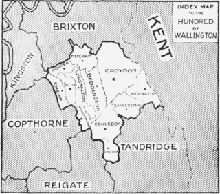
Wallington was an ancient hundred in the northeast of the historic county of Surrey, England. The majority of its area has been absorbed by the growth of London; with its name currently referring to the district of Wallington. Its former area now corresponds to the London Borough of Sutton, the majority of the London Borough of Croydon and parts of the London Borough of Merton as well as parts of the Districts of Epsom and Ewell, Reigate and Banstead and Tandridge in Surrey.
References
- ↑ "Orpington Urban District". A Vision of Britain through Time. GB Historical GIS / University of Portsmouth. Retrieved 24 July 2022.
- ↑ Royal Commission on Local Government in Greater London: 1957–1960: Report, 1960, HMSO
