Harmondsworth is a village in the London Borough of Hillingdon in the county of Greater London with a short border to the south onto London Heathrow Airport and close to the Berkshire county border. The village has no railway stations, but adjoins the M4 motorway and the A4 road. Harmondsworth was in the historic county of Middlesex until 1965. It is an ancient parish that once included the large hamlets of Heathrow, Longford and Sipson. Longford and Sipson have modern signposts and facilities as separate villages, remaining to a degree interdependent such as for schooling. The Great Barn and parish church are medieval buildings in the village. The largest proportion of land in commercial use is related to air transport and hospitality. The village includes public parkland with footpaths and abuts the River Colne and biodiverse land in its Regional Park to the west, once the grazing meadows and woodlands used for hogs of Colnbrook.

Ickenham is an area in Greater London, forming the northern part of Uxbridge and within the London Borough of Hillingdon.

Northwood is an area in the London Borough of Hillingdon, North West London, located 14.5 miles (23.3 km) north-west of Charing Cross. Northwood was part of the ancient parish of Ruislip, Middlesex. The area was situated on the historic Middlesex boundary with Hertfordshire, and since being incorporated into Greater London in 1965, has been on the Greater London boundary with that county.

Ruislip is a suburb in the London Borough of Hillingdon in West London. Prior to 1965 it was in Middlesex. Ruislip lies 13.8 miles (22.2 km) west-north-west of Charing Cross, London.

Uxbridge is a suburban town in west London and the administrative headquarters of the London Borough of Hillingdon. Situated 15.4 miles (24.8 km) west-northwest of Charing Cross, it is one of the major metropolitan centres identified in the London Plan. Uxbridge formed part of the parish of Hillingdon in the county of Middlesex, and was a significant local commercial centre from an early time. As part of the suburban growth of London in the 20th century it expanded and increased in population, becoming a municipal borough in 1955, and has formed part of Greater London since 1965.
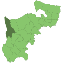
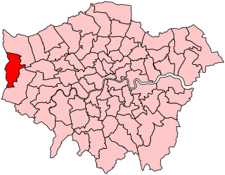
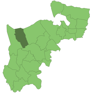
The London Borough of Hillingdon is the largest and westernmost borough in West London, England. It was formed in 1965 from the districts of Hayes and Harlington, Ruislip-Northwood, Uxbridge, and Yiewsley and West Drayton in the ceremonial county of Middlesex. Today, Hillingdon is home to Heathrow Airport and Brunel University, and is the second largest of the 32 London boroughs by area.

Middlesex was a county in southeast England. Its area was almost entirely within the wider urbanised area of London and mostly within the ceremonial county of Greater London, with small sections in neighbouring ceremonial counties. The county's boundaries largely followed three rivers: the Thames in the south, the Lea to the east and the Colne to the west. A line of hills formed the northern boundary with Hertfordshire.

Uxbridge is a London Underground station in Uxbridge in the London Borough of Hillingdon, West London. The station is the terminus of the Uxbridge branches of both the Metropolitan line and the Piccadilly line. The next station towards London is Hillingdon. The station is 15.5 miles (25 km) west of Charing Cross and is in Travelcard Zone 6. The closest station on the Chiltern Line and Central line is West Ruislip, accessible by the U1 and U10 buses. The closest station on the Elizabeth line is West Drayton, accessible by the U1, U3, U5 and 222 buses. Uxbridge was formerly the terminus of a branch of the District line which ran from Ealing Common; the Piccadilly line took over in 1933.

Hendon was an ancient parish of around 8,250 acres (33 km2) in Middlesex, on the border with Hertfordshire. As well as Hendon itself, the parish included Childs Hill, Golders Green and Mill Hill. In 1879 the parish was made a local government district. Such districts became urban districts in 1894. In 1931 the urban district absorbed the neighbouring parish of Edgware, and the following year the urban district was incorporated to become a municipal borough. The borough was abolished in 1965 when the area was transferred from Middlesex to Greater London and became part of the London Borough of Barnet.
Uxbridge was a seat returning one Member of Parliament (MP) of the House of Commons of the UK Parliament from 1885 to 2010. Its MPs elected were: Conservative Party candidates for 107 years and Labour Party candidates for 18 years. The closing 40 years of the seat's history saw Conservative victory — in 1997 on a very marginal majority in relative terms.

Elthorne was a hundred of the historic county of Middlesex, England.
Ruislip-Northwood was an urban district in west Middlesex, England, from 1904 to 1965. From its inception Ruislip-Northwood fell within the Metropolitan Police District and from 1933 it was part of the London Passenger Transport Area.

Uxbridge Rural District was, from 1894 to 1929, a local government district in Middlesex, England.

Hayes and Harlington was a local government, urban district in west Middlesex, England from 1904 to 1965.
Yiewsley and West Drayton was a local government district in Middlesex, England from 1929 to 1965. Its area became the south-west of the London Borough of Hillingdon.

Ruislip Manor is an area of Ruislip in the London Borough of Hillingdon in West London. It is located approximately 13 miles (20.9 km) west north west of Charing Cross.

Northolt Manor is a 1.8 hectare scheduled monument, local nature reserve and Site of Borough Importance for Nature Conservation, Grade II, in Northolt in the London Borough of Ealing. It is owned and managed by Ealing Council.
Islip Manor Meadows is a 23.75 hectare Local Nature Reserve and Site of Metropolitan Importance for Nature Conservation in Northolt in the London Borough of Ealing. It is owned and managed by Ealing Council.
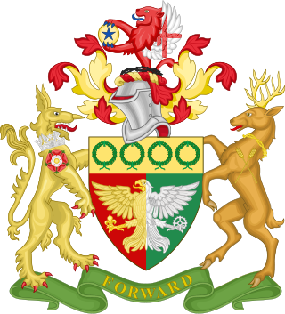
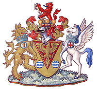
The coat of arms of the London Borough of Hillingdon is the official symbol of the London Borough of Hillingdon. They use elements from the coats of arms of the four previous districts. It is described as:
Arms: Per pale Gules and Vert an Eagle displayed per pale Or and Argent in the dexter claw a Fleur-de-lis Or and in the sinister claw a Cog-Wheel Argent on a Chief Or four Civic Crowns Vert.
Crest: On a Wreath of the Colours issuant from a Circlet of Brushwood Sable a demi-Lion Gules with wings Argent the underside of each wing charged with a Cross Gules and holding between the paws a Bezant thereon a Mullet Azure.
Supporters: On the dexter side an Heraldic Tiger Or gorged with an Astral Crown Azure and charged on the shoulder with a Rose Gules charged with another Argent barbed and seeded proper and on the sinister side a Stag proper attired and gorged with a Circlet of Brushwood and charged on the shoulder with two Ears of Rye slipped in saltire Or.
Motto: Forward.

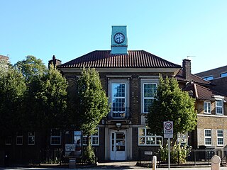
Hillingdon Civic Centre is a municipal building in the High Street, Uxbridge. The civic centre, which is the headquarters of Hillingdon London Borough Council, is a Grade II listed building.