Municipal Borough of Leyton

Last updated

Leyton
Leytontownhall.jpg
Leyton Town Hall
Leyton essex 1961.png
Leyton within Essex in 1961
Area
  19012,594 acres (10.5 km2)
  19312,594 acres (10.5 km2)
  19612,595 acres (10.5 km2)
Population
  190198,912
  1931128,313
  196193,959
Density
  190138.1/acre
  193149.5/acre
  196136.2/acre
History
  OriginLeyton St Mary ancient parish
  Created1873
  Abolished1965
  Succeeded by London Borough of Waltham Forest
Status Local government district (1873–1894)
Urban district (1894–1926)
Municipal borough (1926–1965)
GovernmentLeyton Local Board (1873–1894)
Leyton Urban District Council (1894–1926)
Leyton Borough Council (1926–1965)
   HQ High Road, Leyton
   Motto MINISTRANDO DIGNITAS (Dignity in service)
Leytonstone Library 3.jpg
Leyton's coat of arms outside Leytonstone Library
Subdivisions
  TypeCivil parishes
  UnitsLeyton (1873–1965) [note a]
Wanstead (part) (1883–1894)
Cann Hall (1894–1965)

Leyton was a local government district in southwest Essex, England, from 1873 to 1965. It included the neighbourhoods of Leyton, Leytonstone and Cann Hall. It was suburban to London, forming part of the London postal district and Metropolitan Police District. It now forms the southernmost part of the London Borough of Waltham Forest in Greater London.

Contents

Background

Leyton St Mary or Low Leyton (sometimes spelt "Layton") [1] was an ancient parish in the Becontree hundred of Essex, England. Originally, the parish had an area of 2,271 acres (919 hectares), which included a detached part to the north of 588 acres (238 hectares), separated from the main part of the parish by a long, narrow exclave of Walthamstow, known as the Walthamstow Slip. To the south, the parish of Wanstead formed a long protrusion known as the Wanstead Slip, which extended to the marshes of the River Lea and divided Leyton from West Ham. [2]

Much of the early governance of the parish was in the hands of the lords of the manors of Leyton and Ruckholt, who held courts baron, a type of manorial court from the medieval period until the 1840s. The lords and their courts appointed public officers such as constables (from 1381), marsh haywards, ale tasters (from 1509), headboroughs (from 1578), tithingmen (from 1584) and a poundkeeper in 1796. They also decided rights of common, who was liable for maintaining roads and bridges, and for making and maintaining infrastructure such as animal pounds, lock ups and stocks. [3]

The vestry

From the 17th century, the local government of Leyton was increasingly controlled by the parish vestry, particularly with regard to the administration of the Poor Laws and levying of the parish rates. Initially only meeting once a year at Easter to elect and appoint parish officers, a second meeting each year was necessary by 1681, a third meeting from 1698 and monthly from 1759. Although the main Easter meeting was held in the parish church vestry room, other meetings were held in pubs or coffee houses, the committee members being entitled to a generous entertainment allowance of 40 shillings twice a year, although this was halved in 1723. Originally the meetings were presided over by the lord of the manor of Ruckholt, until 1695 when the Vicar of Leyton took on that role. A parish clerk is first mentioned in 1623. [3]

The parish appointed a parish beadle from 1718 and two overseers of the poor by 1721, one for Leyton and one for Leytonstone. The parish of Leyton endowed eight alms houses in Church Road and in 1742, built a work house immediately behind them. The work house was closed in 1836, Leyton having joined, along with neighbouring parishes, the West Ham Poor Law Union. The Union built a new work house in Leyton to serve the whole area in 1839–41, the building eventually becoming Langthorne Hospital. A workhouse infirmary built at Whipps Cross in 1900-03 later became Whipps Cross Hospital. [4]

There were two constables, one for Leyton and one for Leytonstone; both were appointed by the vestry from 1733. There was a whipping post at Leyton, replaced by a new one in 1756 when the stocks were also replaced, There was also a watch house and "cage" or lock-up. Leytonstone also had stocks and a watch house; a cage was built at Harrow Green in 1812. The parish of Leyton was incorporated into the Metropolitan Police District in 1840. [3]

Urban District Council

Through house building and construction of the railway the parish expanded as an extra-metropolitan suburb of London. The parish authorities resisted earlier attempts to form a local board of health, but finally adopted the Public Health Act 1872 for the parish of Leyton and Walthamstow Slip, creating a local government district in 1873. It was extended to include part of the parish of Wanstead to the south, known as Wanstead Slip or Cann Hall, from 1875. [5] The board of the new district met in the vestry room until 1882, when new public offices were built in Leyton High Road to the design of J Knight. [3]

Leyton became an urban district in 1894 under the Local Government Act 1894. The 1894 act did not allow parishes to be split between districts, so the portion of Wanstead in the district was reconstituted as a new parish of Cann Hall. Initially there were four wards in the district, but in 1903 it was reorganised into nine wards and then ten in 1920. [3] A town hall was built for the urban district in 1895-96 next to the 1882 offices, which had proved to be too small and were converted into a public library. Designed by John Johnson (died 1920), Leyton Town Hall was described by Nikolaus Pevsner as "Fussy but enjoyable, in an eclectic and enriched Italianate style". [6]

Amongst the infrastructure improvements initiated by the board was the Leyton Urban District Council Tramways; tram services in Leyton remained in local government control until they became the responsibility of the London Passenger Transport Board in 1933. [7]

Municipal Borough

After a formal petition to the Privy Council in 1920, the urban district was incorporated as a municipal borough in 1926. [8] Each of the existing ten wards was represented by one alderman and three councillors. [3] The first mayor of the new borough was James Benjamin Slade, who was knighted in 1927. [9]

Borough arms

The coat of arms of the municipal borough were granted on 27 November 1926. The arms were described as "Or three Chevronels Gules on a Chief Gules a Lion passant Or". The crest was: "On a Wreath Or and Gules a Lion rampant per pale Or and Sable supporting a Crozier Gold". The Latin language motto was "MINISTRANDO DIGNITAS" meaning "dignity in service". Elements of the arms commemorated various families who had held manors within the borough during the Middle Ages, and also the nearby Stratford Langthorne Abbey which had held lands in Leyton before the Dissolution of the Monasteries. [10] The lion and cross-staff on the crest of the Leyton arms have been preserved in the arms of the London Borough of Waltham Forest, which were granted on 1 January 1965. [11]

Abolition

In 1965 the municipal borough was abolished by the London Government Act 1963 and its former area transferred to Greater London from Essex. Its former area was combined with that of the Municipal Borough of Chingford and the Municipal Borough of Walthamstow to form the present-day London Borough of Waltham Forest. [12] The last Mayor of Leyton was Terence Charles Messenger. [9]

Notes

Related Research Articles

<span class="mw-page-title-main">Chingford</span> Human settlement in England

Chingford is a town in east London, England, within the London Borough of Waltham Forest. The centre of Chingford is 9.2 miles (14.8 km) north-east of Charing Cross, with Waltham Abbey to the north, Woodford Green and Buckhurst Hill to the east, Walthamstow to the south, and Edmonton and Enfield to the west. Chingford historically lay in Essex, and has formed part of Greater London since 1965.

<span class="mw-page-title-main">Leyton</span> Town in east London, England

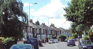
Leyton is a town in east London, England, within the London Borough of Waltham Forest. It borders Walthamstow to the north, Leytonstone to the east, and Stratford to the south, with Clapton, Hackney Wick and Homerton, across the River Lea, to the west. The area includes New Spitalfields Market, Leyton Orient Football Club, as well as part of the Queen Elizabeth Olympic Park. The town consists largely of terraced houses built between 1870 and 1910, interspersed with some modern housing estates. It is 6.2 miles (10 km) north-east of Charing Cross.

<span class="mw-page-title-main">Snaresbrook</span> Area of East London

Snaresbrook is a district of East London in the London Borough of Redbridge. It is located 8 miles east of Charing Cross.

<span class="mw-page-title-main">Walthamstow</span> Town in East London

Walthamstow is a large town in the London Borough of Waltham Forest, around 7+12 miles (12 km) northeast of Central London. Historically part of Essex and now within Greater London for ceremonial and administrative purposes, the town borders Chingford to the north, Snaresbrook and South Woodford to the east, Leyton and Leytonstone to the south, and Tottenham to the west. At the 2011 census, the town had a population of approximately 109,424.

<span class="mw-page-title-main">London Borough of Waltham Forest</span> London borough in United Kingdom

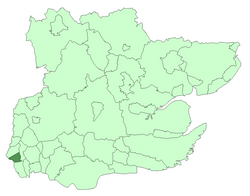
The London Borough of Waltham Forest is a London borough in north-east London, England. Its population is estimated to be 276,983 in 2019. It borders five other London boroughs: Enfield to the north-west, Haringey to the west, Hackney to the south-west, Newham to the south-east and Redbridge to the east, as well as the non-metropolitan county of Essex to the north.

<span class="mw-page-title-main">Leytonstone</span> Area of East London

Leytonstone is an area in East London, England, within the London Borough of Waltham Forest. It adjoins Wanstead to the north-east, Forest Gate to the south-east, Stratford to the south-west, Leyton to the west, and Walthamstow to the north-west, and is 7 miles (11 km) north-east of Charing Cross.

<span class="mw-page-title-main">Walthamstow (UK Parliament constituency)</span> Parliamentary constituency in the United Kingdom, 1974 onwards

Walthamstow is a constituency created in 1974 represented in the House of Commons of the UK Parliament since 2010 by Stella Creasy, a member of the Labour Co-op party. An earlier version of the constituency existed covering a significantly different area (1885–1918) and was among the vast majority by that time returning one member to the House of Commons.

<span class="mw-page-title-main">Municipal Borough of Chingford</span>

Chingford was a local government district in south west Essex, England from 1894 to 1965, around the town of Chingford. It was within the London suburbs, forming part of the London postal district and Metropolitan Police District. Its former area now corresponds to the northern part of the London Borough of Waltham Forest in Greater London.

<span class="mw-page-title-main">Municipal Borough of Walthamstow</span>

Walthamstow was a local government district in southwest Essex, England from 1873 to 1965, around the town of Walthamstow. It was within the London suburbs, forming part of the London postal district and Metropolitan Police District. Its former area now corresponds to the central part of the London Borough of Waltham Forest in Greater London.

<span class="mw-page-title-main">Cann Hall</span> Human settlement in England

Cann Hall is a ward, and former civil parish, in the south of Leytonstone in the London Borough of Waltham Forest. It is north of Stratford and Forest Gate, east of Leyton, and west of Wanstead Flats, the southernmost tip of Epping Forest.

Epping was a parliamentary constituency represented in the House of Commons of the UK Parliament from 1885 to 1974. It elected one Member of Parliament (MP) by the first past the post system of election.

<span class="mw-page-title-main">Whipps Cross</span> Human settlement in England

Whipps Cross is an area of the districts of Leytonstone and Walthamstow in the London Borough of Waltham Forest in London, England. It is most famous for Whipps Cross University Hospital.

Becontree was an ancient hundred in the south west of the county of Essex, England. Its area has been entirely absorbed by the growth of London; with its name reused in 1921 for the large Becontree estate of the London County Council. Its former area now corresponds to the London Borough of Newham, the London Borough of Barking and Dagenham and parts of the London Borough of Waltham Forest and the London Borough of Redbridge. Its early extent also included parts of what is now the London Borough of Havering.

<span class="mw-page-title-main">Stratford Langthorne Abbey</span>

Stratford Langthorne Abbey, or the Abbey of St Mary's, Stratford Langthorne was a Cistercian monastery founded in 1135 at Stratford Langthorne — then Essex but now Stratford in the London Borough of Newham. The Abbey, also known as West Ham Abbey as it lay in that parish, was one of the largest Cistercian abbeys in England, possessing 1,500 acres (6.07 km2) of local land, controlling over 20 manors throughout Essex. The Abbey was self-sufficient for its needs and wealthy besides; some of this wealth came from the ecclesiastic mills grinding wheat for local bakers to supply bread to the City of London. This later led to competition with the Guild of Bakers, who sought powers to levy a toll on loaves entering the City at Whitechapel.

<span class="mw-page-title-main">Woodford, London</span> Human settlement in England

Woodford is a town in East London, within the London Borough of Redbridge. It is located 9.5 miles (15.3 km) north-east of Charing Cross. Woodford historically formed an ancient parish in the county of Essex. It contained a string of agrarian villages and was part of Epping Forest. From about 1700 onwards, it became a place of residence for affluent people who had business in London; this wealth, together with its elevated position, has led to it being called the Geographical and social high point of East London. Woodford was suburban to London and after being combined with Wanstead in 1934 it was incorporated as a municipal borough in 1937. It has formed part of Greater London since 1965 and comprises the neighbourhoods of Woodford Green, Woodford Bridge, Woodford Wells and South Woodford. The area is served by two stations on the Central line of the London Underground: Woodford and South Woodford.

<span class="mw-page-title-main">West Ham Union Workhouse</span>

West Ham Union Workhouse was a workhouse in Leytonstone, built in the village of Holloway Down between 1839 and 1841 and run by the West Ham Poor Law Union. That Union covered several parishes in what is now Newham, Redbridge and Waltham Forest. West Ham Borough Council took over its running in 1930 and renamed it the Central Home Public Assistance Institution, using it as a home for the infirm, aged and chronically sick. In 1948 it formally became a National Health Service hospital under the name of the Langthorne Hospital, which remained open until 1999.

Holloway Down was a village, historically in Essex and now part of Leytonstone in the London Borough of Waltham Forest. The village was sited at the junction of Union Lane and Leytonstone Road It is most notable as the location of the West Ham Union Workhouse, While the village has been replaced by Victorian terraces and shops, buildings from the workhouse remain; which have been converted into housing and part of North East London NHS Foundation Trust.

<span class="mw-page-title-main">Old Town Hall, Walthamstow</span> Municipal building in Walthamstow, London, England

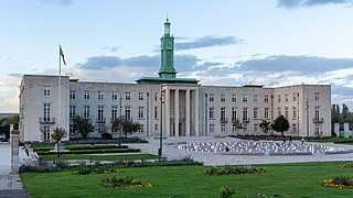
The Old Town Hall is a former municipal building in Orford Road, Walthamstow, London. The building served in a municipal capacity from 1866 to 1942 and then served as the main entrance block to the Connaught Hospital from 1959 to 1977. It is a Grade II listed building.

<span class="mw-page-title-main">Leyton Town Hall</span> Municipal building in London, England

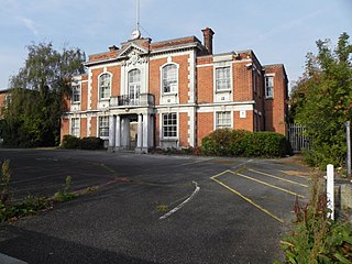
Leyton Town Hall is a municipal building in Adelaide Road, Leyton, London. The building, which includes Leyton Great Hall, is a Grade II listed building.

<span class="mw-page-title-main">St Mary's Church, Leyton</span> Church in London, England

The Parish Church of St Mary with St Edward and St Luke, Leyton, also known as Leyton Parish Church and formerly, St Mary the Virgin, Leyton, is a Church of England parish church in Leyton, East London. Although records of the church go back to about 1200, it has been repeatedly rebuilt; the oldest surviving fabric dates to 1658, but a majority of it is from the early 19th century. It is a Grade II* listed building.

References

  1. "Place names, A Vision of Britain through Time - Leyton Essex". www.visionofbritain.org.uk. GB Historical GIS / University of Portsmouth. Retrieved 27 May 2017.
  2. Powell, W R, ed. (1973). "Victoria County History - Essex A History of the County of Essex: Volume 6 Leyton: Introduction". www.british-history.ac.uk. British History Online. Retrieved 27 May 2017.
  3. 1 2 3 4 5 6 Powell, W R, ed. (1973). "Victoria County History - Essex A History of the County of Essex: Volume 6 Leyton: Local government and public services". www.british-history.ac.uk. British History Online. Retrieved 27 May 2017.
  4. Higginbotham, Peter. "The Workhouse in West Ham, Essex". www.workhouses.org.uk. Retrieved 29 May 2017.
  5. "Waltham Forest Archives NRA30759 - Leyton Local Board of Health" (PDF). www.nationalarchives.gov.uk. National Archives. Retrieved 29 May 2017. (viewable as a download)
  6. Cherry, Bridget; O'Brien, Charles; Pevsner, Nikolaus, eds. (2005). The Buildings of England, London 5: East. Yale University Press. p. 729. ISBN   0--300-10701-3.
  7. Reed, John (1997). London Tramways. Capital Transport Publishing. ISBN   978-1854141798.
  8. "New Essex Boroughs". Chelmsford Chronicle. 1 October 1926. p. 8.
  9. 1 2 "Leyton Mayors". Waltham Forest Memories. Retrieved 11 May 2020.
  10. "LEYTON BOROUGH COUNCIL". www.civicheraldry.co.uk. Civic Heraldry of England and Wales. Retrieved 25 May 2015.
  11. "WALTHAM FOREST, LONDON BOROUGH OF". www.civicheraldry.co.uk. Civic Heraldry of England and Wales. Retrieved 25 May 2015.
  12. "A Vision of Britain through Time - Waltham Forest LB through time". www.visionofbritain.org.uk. GB Historical GIS / University of Portsmouth. Retrieved 29 May 2017.

51°33′28″N0°0′6″E / 51.55778°N 0.00167°E / 51.55778; 0.00167