Metropolitan Borough of Finsbury

Last updated

Finsbury
Finsbury Town hall1.jpg
Finsbury Town Hall
Metropolitan Borough of Finsbury.svg
Finsbury within the County of London
Area
  1911/1931587 acres (2.38 km2)
  1931586 acres (2.37 km2)
Population
  191187,923
  193169,888
  193132,887
Density
  1911150/acre
  1931119/acre
  193156/acre
History
  Created1900
  Abolished1965
  Succeeded by London Borough of Islington
Status Metropolitan borough (1900—1965)
Civil parish (1915—1965)
GovernmentFinsbury Borough Council
   HQ Rosebery Avenue
   Motto Altiora Petimus (We seek higher things)
Finsbury.jpeg
Coat of arms granted in 1931
Subdivisions
  TypeCivil parish
  Units Charterhouse (2)
Clerkenwell
Glasshouse Yard (3)
St Luke's
St Sepulchre (1)
Metropolitan Borough of Finsbury Map of borough boundary

The Metropolitan Borough of Finsbury was a metropolitan borough within the County of London from 1900 to 1965, when it was amalgamated with the Metropolitan Borough of Islington to form the London Borough of Islington.

Contents

It was the second smallest of the 28 boroughs within the County of London, stretching from Finsbury Pavement and Square northwest towards King's Cross, splitting The Angel as well as including Farringdon station and the GPO complex at Mount Pleasant.

Formation and boundaries

The borough was formed from five civil parishes and extra-parochial places: Charterhouse, Liberty of Glasshouse Yard, St James & St John Clerkenwell, St Luke Middlesex and St Sepulchre Middlesex. In 1915 these five were combined into a single civil parish called Finsbury, which was conterminous with the metropolitan borough. [1]

Previous to the borough's formation it had been administered by three separate local bodies: Holborn District Board of Works, Clerkenwell Vestry and St Luke's Vestry. Charterhouse had not been under the control of any local authority prior to 1900.

The borough covered the areas of Finsbury, Moorfields, Clerkenwell, and St Luke's. It bordered Islington, Shoreditch, the City of London, Holborn and St Pancras.

Town Hall

The metropolitan borough was administered from Finsbury Town Hall on Rosebery Avenue. The building was built as the headquarters of Clerkenwell Vestry, and had been officially opened on 14 June 1895 by Lord Rosebery, the Prime Minister. [2] The architect was C Evans Vaughan, and it was described by Nikolaus Pevsner as a "nice irregular brick building with Tudor windows and lantern". [3] Finsbury Town Hall is now home to the Urdang Academy, a successful performing arts college.

Population and area

Although metropolitan boroughs only dated from 1900, the London County Council compiled statistics in 1901 that show the population growth in London over the preceding century.

The area of the borough in 1901 was 587 acres (2.4 km2). The populations recorded in National Censuses were:

Constituent parishes 1801-1899

Year [4] 1801181118211831184118511861187118811891
Population55,51568,81186,223100,521112,938125,360129,031124,766119,382111,225

Metropolitan Borough 1900-1961

Year [5] 1901191119211931194119511961
Population101,46387,92375,99569,888 [6] 35,37032,887

By comparison, after amalgamation with Islington, to form the modern London Borough of Islington, the combined area became 14.86 km2 - approximately 3,672 acres (14.86 km2); in 2005, this had a population of 182,600, [7] or a population density of 12,288/km2. In 1901 Finsbury, the population density was 42,276/km2.

Coat of arms

Device adopted in 1900 Seal finsbury.png
Device adopted in 1900

When the borough was incorporated in 1900, the corporation adopted a complicated device bearing six shields for each of the constituent parishes and extra-parochial places from which it was formed.

At the top were shields depicting the old Cripplegate of the City of London and the arms of Charterhouse.

At the centre of the seal, on the left, is the shield of Clerkenwell Vestry. The parish church was dedicated to Ss. James and John, and the shield showed St. James on the left and the cross of St. John on the right.

To the right of this was the emblem of St Luke's parish: as patron saint of artists, Luke was shown seated at an easel.

At the left base of the seal was a depiction of the gate of St. Botolph, representing the Liberty of Glasshouse Yard.

The design was completed by the shield of the parish vestry of St. Sepulchre. This parish was originally partly in the City of London, and partly in the county of Middlesex, and the shield combined the arms used bt the city and county.

In 1931 the borough received a grant of arms from the College of Arms. This also included references to Finsbury's constituent parts, but in a more unified design. The shield had the cross of St John, on which were placed a heraldic fountain for the New River and roundels and rings from the arms of Charterhouse School. At the top of the shield was a representation of the city wall and its gates.

The crest on top of the helm was for St Sepulchre's parish, the shield held by the hand again combining elements of the arms of the City of London and Middlesex.

The supporters were a winged bull, emblem of St. Luke; and an heraldic dolphin, symbol of St. James. The dolphin supporter was "charged" with a well in reference to Clerkenwell.

The Latin motto chosen by the borough was Altiora Petimus or We seek higher things.

Politics

A map showing the wards of Finsbury Metropolitan Borough as they appeared in 1952 Finsbury Met. B Ward Map 1952.svg
A map showing the wards of Finsbury Metropolitan Borough as they appeared in 1952
Civil parishes in 1911 Finsbury parishes 1911.png
Civil parishes in 1911

The borough was divided into eleven wards for elections: City Road East, City Road West, East Finsbury, Old Street, Pentonville, St James', St John's, St Mark's, St Phillip's, St Sepulchre and West Finsbury. [8] [9]

Borough council

The first borough council was elected on 1 November 1900, when Conservative-supported Unionist and Moderate candidates took control. From 1903 to 1906 the Progressive Party held power. From 1906 to 1925 the Municipal Reform Party (allied to the Conservatives) controlled the borough. In 1925 a Ratepayer's Association stood in place of the Municipal Reformers, replacing them as majority party. From 1928 to 1931, the Labour Party held control, with the Ratepayers holding power from 1931 to 1934. In 1934 Labour regained power, which it held until the abolition of the borough in 1965.

The number of councillors returned at each election to the council was as follows: [10]

Local elections
Year1900190319061909191219191922192519281931193419371945
Unionists14
Moderates4
Progressives1032148517
Liberals5
Independent11
Pro-conservatives22
Municipal Reform34464832476
Ratepayers Assoc40274798
Labour15714299474847
Unofficial Labour2
Communist1

No Municipal Reform candidates were nominated after 1946, and Conservative candidates were nominated at local elections for the first time.

Year19491953195619591962
Labour24372932
Conservative5252
Vacancies5

Parliamentary constituency

For elections to Parliament, the borough initially formed the two constituencies of Finsbury Central and Finsbury East. In 1918 a new constituency of Finsbury was formed which was identical with the metropolitan borough. By 1950 the population of the borough had declined to such an extent that the Finsbury constituency was merged with the neighbouring constituency of Shoreditch to become Shoreditch and Finsbury.[ citation needed ]

Archival records

Surviving Borough of Finsbury road sign Whitecross Street EC1 sign 1.jpg
Surviving Borough of Finsbury road sign

Islington Local History Centre holds records of the Metropolitan Borough of Finsbury, including council and committee minutes, rate books, publications and photographs. [11] There are some street nameplates which retain the label "Borough of Finsbury".

See also

Related Research Articles

<span class="mw-page-title-main">London Borough of Islington</span> Borough in United Kingdom

The London Borough of Islington is a London borough which forms part of Inner London. Islington has an estimated population of 215,667. It was formed in 1965 under the London Government Act 1963, which simultaneously abolished the metropolitan boroughs of Islington and Finsbury.

<span class="mw-page-title-main">Clerkenwell</span> Area of central London

Clerkenwell is an area of central London, England.

<span class="mw-page-title-main">Finsbury</span> District of Central London

Finsbury is a district of Central London, forming the south-eastern part of the London Borough of Islington. It borders the City of London.

<span class="mw-page-title-main">County of London</span> County of England between 1889 and 1965

The County of London was a county of England from 1889 to 1965, corresponding to the area known today as Inner London. It was created as part of the general introduction of elected county government in England, by way of the Local Government Act 1888. The Act created an administrative County of London, which included within its territory the City of London. However, the City of London and the County of London formed separate ceremonial counties for "non-administrative" purposes. The local authority for the county was the London County Council (LCC), which initially performed only a limited range of functions, but gained further powers during its 76-year existence. The LCC provided very few services within the City of London, where the ancient Corporation monopolised local governance. In 1900, the lower-tier civil parishes and district boards were replaced with 28 new metropolitan boroughs. The territory of the county was 74,903 acres (303.12 km2) in 1961. During its existence, there was a long-term decline in population as more residents moved into the outer suburbs; there were periodic reviews of the local government structures in the greater London area and several failed attempts to expand the boundaries of the county. In 1965, the London Government Act 1963 replaced the county with the much larger Greater London administrative area.

Farringdon is a small district in Central London, the southern part of the London Borough of Islington. The term is used to describe the area around Farringdon station. Historically the district corresponded to southern Clerkenwell and the small parish of St Sepulchre Middlesex.

<span class="mw-page-title-main">Metropolitan Borough of Islington</span> Former local authority of London, England

Islington was a civil parish and metropolitan borough in London, England. It was an ancient parish within the county of Middlesex, and formed part of The Metropolis from 1855. The parish was transferred to the County of London in 1889 and became a metropolitan borough in 1900. It was amalgamated with the Metropolitan Borough of Finsbury to form the London Borough of Islington in Greater London in 1965.

<span class="mw-page-title-main">Metropolitan Borough of Chelsea</span> Former borough of London

The Metropolitan Borough of Chelsea was a metropolitan borough of the County of London between 1900 and 1965. It was created by the London Government Act 1899 from most of the ancient parish of Chelsea. Following the London Government Act 1963, it was amalgamated with the Royal Borough of Kensington in 1965 to form the Royal Borough of Kensington and Chelsea.

<span class="mw-page-title-main">Metropolitan Borough of Stoke Newington</span>

The Metropolitan Borough of Stoke Newington was a metropolitan borough in the County of London between 1900 and 1965 when it became part of the London Borough of Hackney.

<span class="mw-page-title-main">Metropolitan Borough of Shoreditch</span>

The Metropolitan Borough of Shoreditch was a Metropolitan borough of the County of London between 1899 and 1965, when it was merged with the Metropolitan Borough of Stoke Newington and the Metropolitan Borough of Hackney to form the London Borough of Hackney.

<span class="mw-page-title-main">St Luke's, London</span> Human settlement in England

St Luke's is an area in central London in the Borough of Islington. It lies just north of the border with the City of London near the Barbican Estate, and the Clerkenwell and Shoreditch areas. The area takes its name from the now redundant parish church of St Luke's, on Old Street west of Old Street station. Following the closure of the church, the parish was reabsorbed into that of St Giles-without-Cripplegate, from which it had separated in 1733.

<span class="mw-page-title-main">St Sepulchre (parish)</span> Ancient parish in England

St Sepulchre was an ancient parish which had its southern part within the boundaries of the City of London and its northern part outside. Its former area is now within the contemporary neighbourhoods of Smithfield, Farringdon and Clerkenwell.

Hornsey was an ancient parish in the county of Middlesex. It was both a civil parish, used for administrative purposes, and an ecclesiastical parish of the Church of England.

The Finsbury Division was one of four divisions of the Hundred of Ossulstone, in the historic county of Middlesex, England. The area of the Finsbury Division is now the core of modern north London. The other divisions were named Holborn, Kensington and Tower. Ossulstone hundred was divided in the seventeenth century, with each of the four divisions replacing the hundred for most administrative purposes.

The parliamentary borough of Finsbury was a constituency of the House of Commons of the UK Parliament from 1832 to 1885, and from 1918 to 1950. The constituency was first created in 1832 as one of seven two-seat "metropolis" parliamentary boroughs other than the two which already existed: Westminster and the City of London; the latter until 1885 retained an exceptional four seats. Finsbury was directly north of the City of London and was smaller than the Finsbury division of the Ossulstone hundred but took in land of Holborn division to its southwest in pre-introduction changes by Boundary Commissioners. It included Finsbury, Holborn, Moorfields, Clerkenwell, Islington, Stoke Newington and historic St Pancras. The 1918 constituency corresponded to the smaller Metropolitan Borough of Finsbury ; it was a seat, thus electing a single member, fulfilling a longstanding aim of Chartism which underscored the 1832 reforms.

<span class="mw-page-title-main">Islington London Borough Council</span>

Islington London Borough Council is the local authority for the London Borough of Islington in Greater London, England. The council was created by the London Government Act 1963 and replaced two local authorities: Finsbury Metropolitan Borough Council and Islington Metropolitan Borough Council.

Finsbury Central was a parliamentary constituency that covered the Clerkenwell district of Central London. It returned one Member of Parliament (MP) to the House of Commons of the Parliament of the United Kingdom, elected by the first past the post system.

Finsbury East was a parliamentary constituency centred on the Finsbury district of North London, England. It returned one Member of Parliament (MP) to the House of Commons of the Parliament of the United Kingdom, elected by the first past the post system.

<span class="mw-page-title-main">Angel, London</span> Human settlement in England

Angel is an area on the northern fringes of Central London within the London Borough of Islington. It is 2 miles (3.2 km) north-northeast of Charing Cross on the Inner Ring Road at a busy transport intersection. The area is identified in the London Plan as one of 35 major centres in London. It is a significant commercial and retail centre, and a business improvement district. Angel straddles the ancient boundary of the parishes of Clerkenwell and Islington that later became the metropolitan boroughs of Finsbury and Islington. It is named from the former Angel Inn which stood on the corner of Islington High Street and Pentonville Road. Since 1965 the whole area has formed part of the London Borough of Islington in Greater London.

<span class="mw-page-title-main">Glasshouse Yard</span>

The Liberty of Glasshouse Yard was an extra-parochial liberty adjacent to the City of London. The liberty took its name from a glass manufacturing works established there. The area now forms part of the London Borough of Islington.

<span class="mw-page-title-main">Finsbury Town Hall</span> Municipal building in London, England

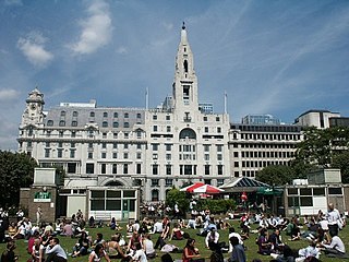
Finsbury Town Hall is a municipal building in Finsbury, London. The structure is a Grade II* listed building.

References

  1. "Finsbury CP through time: Census tables with data for the Parish-level Unit, A Vision of Britain through Time". GB Historical GIS / University of Portsmouth. Retrieved 19 February 2015.
  2. "Lord Rosebery On London Government". The Times . 15 June 1895. p. 16.
  3. Pevsner, Nikolaus (1952). London except the Cities of London and Westminster. The Buildings of England. Harmondsworth: Penguin. p. 115.
  4. Statistical Abstract for London, 1901 (Vol. IV)
  5. Islington MetB: Census Tables at Vision of Britain accessed on 14 Dec 2006
  6. The census was suspended for World War II
  7. 2005 estimate
  8. Post Office London County Suburbs Directory, 1919. 1919. Retrieved 18 February 2015.
  9. Ordnance Survey 'County Series 3rd Edition' Map of London (1912-14) at 1:2500 scale. Accessed at https://www.old-maps.co.uk/
  10. Times Digital Library
  11. "Local History Collections". Islington Local History Centre. Archived from the original on 17 January 2011. Retrieved 3 March 2011.

Sources

51°31′36″N0°06′29″W / 51.5268°N 0.1080°W / 51.5268; -0.1080