Metropolitan Borough of Bermondsey

Last updated

Bermondsey
BermondseyTownHall19SpaRd.jpg
The former Bermondsey Town Hall
Metropolitan Borough of Bermondsey.svg
Bermondsey within the County of London
Area
  19111,500 acres (6.1 km2)
  19311,503 acres (6.08 km2)
  19611,504 acres (6.09 km2)
Population
  1911125,903
  1931111,542
  196151,860
Density
  191184/acre
  193174/acre
  196134/acre
History
  Origin Bermondsey parish
Rotherhithe parish
St Olave District
  Created1900
  Abolished1965
  Succeeded by London Borough of Southwark
Status Metropolitan borough
GovernmentBermondsey Borough Council
   HQ Spa Road
   Motto Prosunt gentibus artes (Arts profit the people)
Bermondsey arms.png
Coat of arms of the borough council
Metropolitan Borough of Bermondsey Map of borough boundary

The Metropolitan Borough of Bermondsey was a Metropolitan borough in the County of London, created in 1900 by the London Government Act 1899. It was abolished and its area became part of the London Borough of Southwark in 1965.

Contents

Formation and boundaries

The borough was formed from four civil parishes: St Mary Magdalen Bermondsey, St Mary Rotherhithe, Southwark St John Horsleydown and Southwark St Olave and St Thomas. In 1904 these four were combined into a single civil parish called Bermondsey, which was conterminous with the metropolitan borough. [1]

Previous to the borough's formation it had been administered by three separate local bodies: St Olave District Board of Works, Bermondsey Vestry and Rotherhithe Vestry. [2]

History

The Victorian vestry hall on Spa Road, SE16, was bombed during the Second World War. After the war the neighbouring Municipal Offices (1928, designed by H Tansley) took over the role. [3] Bermondsey Town Hall continued to house civic offices, latterly for Southwark Council, until being sold off in 2012. [4]

The population declined sharply after the Second World War, being cut by about half from 1931 to 1951.

Coat of arms

The borough was granted a coat of arms in 1901. [5] The design included references to the three constituent authorities. The lion, crozier and two letters B represent Bermondsey vestry, and are derived from the insignia of Bermondsey Abbey. The crown and axe were the emblem of St Olave's District Board of Works, and were derived from the royal arms of Norway, Saint Olave being the anglicised name of King Olaf II of Norway. The ship represented Rotherhithe and the Surrey Commercial Docks. The symbolism in the coat of arms were incorporated into a sculpture called The Bermondsey Lion that was unveiled in The Blue in 2011. [6]

The Latin motto adopted by the borough was Prosunt gentibus artes or "Arts profit the people", [6] and was adapted from Ovid's Metamorphoses .

Population and area

The area of the borough was 1,504 acres (6.1 km2). The population from the Census returns was:

Constituent parishes 1801–1899

Year [7] 1801181118211831184118511861187118811891
Population46,28149,39757,14862,63768,70185,308101,913122,398134,632136,660

Metropolitan Borough 1900-1961

Year [8] 1901191119211931194119511961
Population130,760125,903119,452111,542 [9] 60,63851,860

Politics

A map showing the wards of Bermondsey Metropolitan Borough as they appeared in 1916. Bermondsey Met. B Ward Map 1916.svg
A map showing the wards of Bermondsey Metropolitan Borough as they appeared in 1916.

The borough was divided into twelve wards for elections: No. 1 Bermondsey, No. 2 Bermondsey, No. 3 Bermondsey, No. 4 Bermondsey, No. 5 Bermondsey, No. 6 Bermondsey, No. 1 Rotherhithe, No. 2 Rotherhithe, No. 3 Rotherhithe, St John, St Olave and St Thomas. [10] [11]

Borough council

In the first election to the borough council, held on 1 November 1900 the Moderates (supported by the Conservative party) gained a majority. The opposition group was formed by the Progressive Party. The Moderates retained their majority at the 1903 elections. In 1906 the Moderate group was renamed Municipal Reform. In 1909 The Progressives won 27 seats and the Independent Labour Party 1 to the Municipal Reform's 26 seats, but the latter party retained power through the aldermanic elections. They regained an overall majority of councillors at the 1912 elections.

Local elections were postponed during the First World War, with the next poll held in 1919. The results were a major reverse for the Municipal Reform party with just two councillors elected. The Progressives formed the largest party with 27 seats, followed by the Labour Party with 24. There was one independent councillor. At the 1922 elections Labour gained a majority with 38 seats. The opposition was formed by a Ratepayers Association with 14 councillors. Labour held the council at the subsequent elections, holding all the seats from 1934 to 1945 and from 1949 until the borough's abolition. [12]

Parliament constituency

For elections to Parliament, the borough was divided into two constituencies:

In 1918 the boundaries of the borough's two seats were adjusted, and one was renamed:

In 1950 the borough's representation was reduced to one seat:

Related Research Articles

<span class="mw-page-title-main">Bermondsey</span> District in the London Borough of Southwark

Bermondsey is a district in southeast London, part of the London Borough of Southwark, England, 2.5 miles (4.0 km) southeast of Charing Cross. To the west of Bermondsey lies Southwark, to the east Rotherhithe and Deptford, to the south Walworth and Peckham, and to the north is Wapping across the River Thames. It lies within the historic county boundaries of Surrey. During the Industrial Revolution Bermondsey became a centre for manufacturing, particularly in relation to tanning. More recently it has experienced regeneration including warehouse conversions to flats and the provision of new transport links.

<span class="mw-page-title-main">Rotherhithe</span> Residential district in south-east London, England

Rotherhithe is a district of south-east London, England, and part of the London Borough of Southwark. It is on a peninsula on the south bank of the Thames, facing Wapping, Shadwell and Limehouse on the north bank, with the Isle of Dogs to the east. It borders Bermondsey to the west and Deptford to the south-east. The district is a part of the Docklands area.

<span class="mw-page-title-main">Metropolitan Borough of Southwark</span>

The Metropolitan Borough of Southwark was a metropolitan borough in the County of London from 1900 to 1965. It was created to cover the western section of the ancient borough of Southwark and the parish of Newington. In common with the rest of inner London, the borough experienced a steady decline in population throughout its existence. The borough council made an unsuccessful attempt to gain city status in 1955. Its former area is now the northwestern part of the current London Borough of Southwark.

<span class="mw-page-title-main">Metropolitan Borough of Camberwell</span> Former Metropolitan Borough in England

Camberwell was a civil parish and metropolitan borough in south London, England. Camberwell was an ancient parish in the county of Surrey, governed by an administrative vestry from 1674. The parish was included in the area of responsibility of the Metropolitan Board of Works in 1855 and became part of the County of London in 1889. The parish of Camberwell became a metropolitan borough in 1900, following the London Government Act 1899, with the parish vestry replaced by a borough council. In 1965 the borough was abolished and its former area became part of the London Borough of Southwark in Greater London.

<span class="mw-page-title-main">Metropolitan Borough of Lambeth</span> Metropolitan borough of England

Lambeth was a civil parish and metropolitan borough in south London, England. It was an ancient parish in the county of Surrey. The parish was included in the area of responsibility of the Metropolitan Board of Works in 1855 and became part of the County of London in 1889. The parish of Lambeth became a metropolitan borough in 1900, following the London Government Act 1899, with the parish vestry replaced by a borough council.

<span class="mw-page-title-main">Metropolitan Borough of Finsbury</span>

The Metropolitan Borough of Finsbury was a metropolitan borough within the County of London from 1900 to 1965, when it was amalgamated with the Metropolitan Borough of Islington to form the London Borough of Islington.

<span class="mw-page-title-main">Metropolitan Borough of Greenwich</span> Former metropolitan borough in London, England

The Metropolitan Borough of Greenwich was a metropolitan borough in the County of London between 1900 and 1965. It bordered the boroughs of Woolwich, Lewisham and Deptford and, across the River Thames, the borough of Poplar and the County Borough of West Ham in Essex. Within the area of the borough were the Royal Naval College, the Royal Observatory and Greenwich Park.

<span class="mw-page-title-main">Metropolitan Borough of Chelsea</span> Former borough of London

The Metropolitan Borough of Chelsea was a metropolitan borough of the County of London between 1900 and 1965. It was created by the London Government Act 1899 from most of the ancient parish of Chelsea. Following the London Government Act 1963, it was amalgamated with the Royal Borough of Kensington in 1965 to form the Royal Borough of Kensington and Chelsea.

<span class="mw-page-title-main">Metropolitan Borough of Battersea</span>

Battersea was a civil parish and metropolitan borough in the County of London, England. In 1965, the borough was abolished and its area combined with parts of the Metropolitan Borough of Wandsworth to form the London Borough of Wandsworth. The borough was administered from Battersea Town Hall on Lavender Hill. That building is now Battersea Arts Centre.

<span class="mw-page-title-main">Metropolitan Borough of Hackney</span>

The Metropolitan Borough of Hackney was a metropolitan borough of the County of London from 1900 to 1965. Its area became part of the London Borough of Hackney.

<span class="mw-page-title-main">Metropolitan Borough of Bethnal Green</span> Civil parish and metropolitan borough in London, England

Bethnal Green was a civil parish and a metropolitan borough of the County of London between 1899 and 1965, when it was merged with the Metropolitan Borough of Stepney and the Metropolitan Borough of Poplar to form the London Borough of Tower Hamlets.

<span class="mw-page-title-main">Metropolitan Borough of Stoke Newington</span> Former London borough, United Kingdom

The Metropolitan Borough of Stoke Newington was a metropolitan borough in the County of London between 1900 and 1965 when it became part of the London Borough of Hackney.

<span class="mw-page-title-main">North Southwark and Bermondsey (UK Parliament constituency)</span> Parliamentary constituency in the United Kingdom, 1997–2010

North Southwark and Bermondsey was a parliamentary constituency which returned one Member of Parliament (MP) to the House of Commons of the Parliament of the United Kingdom. The constituency was created for the 1997 general election.

<span class="mw-page-title-main">Bermondsey and Old Southwark (UK Parliament constituency)</span> UK Parliament constituency in England since 2010

Bermondsey and Old Southwark is a constituency in the House of Commons of the UK Parliament. Since 2015, it has been represented by Neil Coyle, who was elected as a Labour MP but was suspended from the party from 2022 to 2023 following an accusation of racism.

<span class="mw-page-title-main">Rotherhithe (UK Parliament constituency)</span> Parliamentary constituency in the United Kingdom, 1885–1950

Rotherhithe was a parliamentary constituency centred on the Rotherhithe district of South London. It returned one Member of Parliament (MP) to the House of Commons of the Parliament of the United Kingdom, elected by the first past the post system.

<span class="mw-page-title-main">Alfred Salter</span>

Alfred Salter was a British medical practitioner and Labour Party politician.

<span class="mw-page-title-main">St Olave's Hospital</span> Hospital in England

St Olave's Hospital was a general hospital serving the Rotherhithe area of London until its closure in 1985.

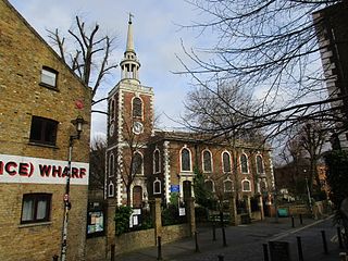
Bermondsey was a parish in the metropolitan area of London, England.

<span class="mw-page-title-main">The Bermondsey Lion</span>

The Bermondsey Lion is a sculpture in The Blue, Bermondsey, London, created by Kevin Boys for Southwark Council. It was unveiled on 16 July 2011.

<span class="mw-page-title-main">Bermondsey Town Hall</span> Municipal building in London, England

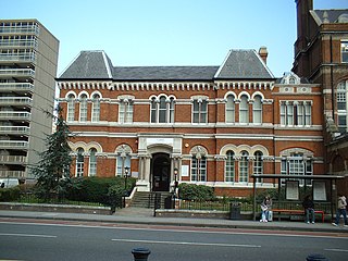
Bermondsey Town Hall is a municipal building in Spa Road, Bermondsey, London. It is a Grade II listed building.
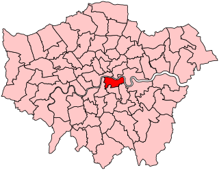
References

  1. "GB Historical GIS / University of Portsmouth, Bermondsey AP/CP/Vest through time: Census tables with data for the Parish-level Unit". A Vision of Britain through Time. Retrieved 19 February 2015.
  2. F A Youngs, Guide to the local administrative units of England, Volume I, 1979
  3. "London's Town Halls". Historic England. p. 167. Retrieved 13 May 2020.
  4. "Bermondsey Town Hall to be converted into 41 homes". SE16. 10 May 2012. Retrieved 13 May 2020.
  5. Letters Patent dated 25 March 1901
  6. 1 2 The plaque on the plinth of The Bermondsey Lion in The Blue (September 2012)
  7. Statistical Abstract for London, 1901 (Vol. IV).
  8. Bermondsey MetB: Census Tables. Retrieved 14 June 2007
  9. The census was suspended for World War II
  10. Post Office London County Suburbs Directory, 1919. 1919. Retrieved 18 February 2015.
  11. "'County Series 3rd Edition' Map of London (1912-14) at 1:2500 scale". Ordnance Survey.
  12. Election results as reported in The Times, 3 November 1900; 4 November 1903; 3 November 1906; 2 November 1909; 2 November 1912; 4 November 1919; 4 November 1925; 3 November 1928; 4 November 1931; 3 November 1934; 3 November 1937; 2 November 1945; 7 May 1949; 7 May 1953; 11 May 1956; 8 May 1959; 12 May 1962

Further reading

51°29′45″N0°04′26″W / 51.4958°N 0.0738°W / 51.4958; -0.0738