Municipal Borough of Finchley

Last updated

Finchley
Finchley1961.svg
Finchley within Middlesex in 1961
Area
  19013,384 acres (13.7 km2)
  19613,477 acres (14.1 km2)
Population
  190122,126
  196169,370
History
  Created1878
  Abolished1965
  Succeeded by London Borough of Barnet
Status Local Government District (1878-1895)
Urban district (1895 - 1933)
Municipal borough (1933 - 1965)
GovernmentFinchley Local Board
Finchley Urban District Council
Finchley Borough Council
   HQ Finchley
   Motto Regnant Qui Serviunt (They rule who serve)
Finchley arms.png
Coat of arms of Finchley Borough Council

Finchley , which is now in north London, was a local government district in Middlesex, England, from 1878 to 1965. Finchley Local Board first met in 1878. It became Finchley District Council in 1895 and the Municipal Borough of Finchley in 1933. In 1965 Middlesex was abolished and Finchley became part of the London Borough of Barnet.

Contents

Formation

The parish of Finchley had no local government in the modern sense until the 19th century. The parish initially resisted adopting the Local Government Act 1858 and forming a local board to govern the town on grounds of cost. However, this meant that the area was grouped with a number of other parishes under the control of Barnet Rural Sanitary Authority in 1873.

It was the fear of losing power over local administration to Barnet that was to lead the ratepayers of Finchley to adopt the 1858 legislation. Finchley Local Board was formed in 1878, consisting of twelve members. There was tension between the ratepayers of North Finchley and the wealthier Church End area as those owning more property had more votes under the weighted voting system used. A proposal to merge with the neighbouring Friern Barnet Local Government District in 1881 was not carried out. [1]

Urban district

Wards of the Finchley Urban District Finchley UD ward map 1930s.svg
Wards of the Finchley Urban District

The Local Government Act 1894 redesignated various urban local government areas as urban districts, and Finchley Local Board became Finchley District Council in 1895. The tension that had existed in the local board continued among the twelve-member council until the urban district was divided into three wards (East, North and West), each electing four councillors, in 1898. [1]

Incorporation

Wards of the Finchley Municipal Borough Finchley MB Ward Map 1950s.svg
Wards of the Finchley Municipal Borough

In 1926 consideration was first given to applying for a charter of incorporation to create Finchley a municipal borough. This was in response to fears that the area would be absorbed by the County of London, or lose powers to Middlesex County Council. [1] Application was not made until March 1932, however, when a petition to the privy council was made by the inhabitant householders of the urban district. [2] The petition was successful, and on 5 October 1933, the charter was presented to the Charter Mayor, councillor Vyvyan Wells by the Earl of Athlone. [3]

The town council consisted of a mayor, six aldermen and eighteen councillors. Two councillors were elected for each of the three wards annually, and half of the aldermen were elected by the council every three years. The borough council subsequently increased in size in 1950 to 24 councillors and eight aldermen, with three councillors and one alderman representing each of eight wards: Glebe, Manor, Moss Hall, St Mary's, St Paul's, The Bishop's, Tudor, and Whetstone. [1]

The Finchley Lido was the first element in a Finchley complex which was to include a town hall for which plans were drawn up in 1936 but never realised. [4]

Borough council

The borough council was initially controlled by the Conservative Party. Opposition was provided by a handful of independents and a single Labour Party councillor. There was little or no change in the composition of the council prior to the outbreak of the Second World War in 1939, when elections were cancelled. [5] [6]

Following the ending of the conflict, elections were again held in 1945, with Independents taking every seat on the council. [7] The Conservatives were able to regain a majority at the 1949 council election. [8] From the enlargement of the council in 1950 to the elections of 1957 the membership was 29 Conservatives and three Labour members. [9] [10] In the latter year Liberals returned to the council, and quickly became the second-largest group on the council. [11] At the final elections to Finchley council in 1963, the Liberals gained a majority of councillors and aldermen, with 19 seats to 13 for the Conservatives. [12]

Coat of arms

Following the successful petition for municipal incorporation, the borough council was granted armorial bearings by the College of Arms by letters patent dated 10 July 1933. The arms were blazoned as follows:

Vert on a Chevron raguly between in chief two Bugle Horns stringed Or and in base a Mitre Argent garnished Gold a Rose Gules surmounted by another Argent.

And for a Crest On a Wreath Or and Vert a Finch proper resting the dexter claw on an Escutcheon Or changed with a Fleur-de-Lys Gules.

Supporters: On the dexter side a Lion and on the sinister side a Stag proper each gorged with a Collar suspended therefrom a Bugle Horn ensigned with a Ducal Coronet Or. [13]

The arms had a green field, across which was placed a "raguly" chevron: the rough edges suggesting sawn off branches. Together these represented the oak woods that once covered much of Finchley. The area had been a favourite hunting ground of the Tudor monarchs, indicated by the hunting horns and Tudor Rose. The bishop's mitre recalled that much of Finchley belonged to the Bishops of London. The crest, placed on top of a helm and mantling, was an heraldic pun: a finch supporting a shield bearing a fleur de lis, for Finchley. The dexter supporter was a lion, from the arms of the Countess of Pembroke, from whom the Comptons, lord of the manor were descended. The sinister supporter was a stag, referring back to the ancient forest. [14]

Abolition

Under the London Government Act 1963, the municipal borough was abolished, with its area merging with the municipal borough of Hendon and the urban districts of Barnet, East Barnet and Friern Barnet to form the London Borough of Barnet on 1 April 1965.

Twinning

Finchley Borough had four twin towns; the London Borough of Barnet continues these links:

See also

Related Research Articles

<span class="mw-page-title-main">Finchley</span> District of London, England

Finchley is a large district of north London, England, in the London Borough of Barnet. Finchley is on high ground, 11 km (6.8 mi) north of Charing Cross.

<span class="mw-page-title-main">London Borough of Barnet</span> Borough in the United Kingdom

The London Borough of Barnet is a suburban London borough in North London. The borough was formed in 1965 from parts of the ceremonial counties of Middlesex and Hertfordshire. It forms part of Outer London and is the second largest London borough by population with 389,344 inhabitants, also making it the 17th largest district in England. The borough covers an area of 86.74 square kilometres (33 sq mi), the fourth highest of the 32 London boroughs, and has a population density of 45.8 people per hectare, which ranks it 25th.

<span class="mw-page-title-main">Metropolitan Borough of Hackney</span>

The Metropolitan Borough of Hackney was a Metropolitan borough of the County of London from 1900 to 1965. Its area became part of the London Borough of Hackney.

<span class="mw-page-title-main">Metropolitan Borough of Stoke Newington</span>

The Metropolitan Borough of Stoke Newington was a metropolitan borough in the County of London between 1900 and 1965 when it became part of the London Borough of Hackney.

<span class="mw-page-title-main">Finchley (UK Parliament constituency)</span> Parliamentary constituency in the United Kingdom, 1918–1997

Finchley was a constituency represented in the House of Commons of the Parliament of the United Kingdom. It elected one Member of Parliament (MP) by the first-past-the-post system of election; its best-known MP was Margaret Thatcher, Prime Minister from 1979 to 1990. Although boundary changes meant that she never again attained her large majority of 1959, she was nonetheless returned by comfortable (9,000) majorities at general elections throughout her premiership.

<span class="mw-page-title-main">New Southgate</span> Human settlement in England

New Southgate is a residential suburb straddling three Outer London Boroughs: a small part of the east of Barnet, a south-west corner of Enfield and in loosest definitions, based on nearest railway stations, a small northern corner of Haringey in North London, England where estates merge into Bounds Green.

<span class="mw-page-title-main">Friern Barnet</span> Human settlement in England

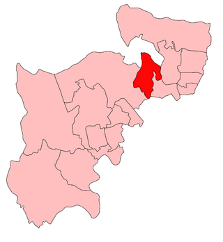
Friern Barnet is a suburban area within the London Borough of Barnet, 7.4 miles (11.9 km) north of Charing Cross. Its centre is formed by the busy intersection of Colney Hatch Lane, Woodhouse Road and Friern Barnet Road.

<span class="mw-page-title-main">Friern Barnet Urban District</span>

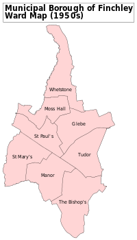
Friern Barnet Urban District was a local government area in Middlesex, England created in 1883 from the civil parish Friern Barnet. It was succeeded by the London Borough of Barnet in 1965 as one of the smaller of its contributory predecessor districts. It was at the local level governed for nine years by the local board, then by Friern Barnet Urban District Council which operated primarily with separate functions from the County Council, operating occasionally for major planning decisions and major projects together with that body, Middlesex County Council.

<span class="mw-page-title-main">Municipal Borough of Ealing</span>

Ealing was a local government district from 1863 to 1965 around the town of Ealing which formed part of the built up area of London until 1965, where it became part of Greater London.

<span class="mw-page-title-main">Municipal Borough of Southall</span>

Southall was a local government district in the county of Middlesex, United Kingdom from 1891 to 1965. It consisted of the civil parish of Norwood.

<span class="mw-page-title-main">Municipal Borough of Twickenham</span>

Twickenham was a local government district in Middlesex, England from 1868 to 1965.

<span class="mw-page-title-main">Middlesex County Council</span>

Middlesex County Council was the principal local government body in the administrative county of Middlesex from 1889 to 1965.

<span class="mw-page-title-main">London Government Act 1963</span> United Kingdom legislation

The London Government Act 1963 is an Act of the Parliament of the United Kingdom, which created Greater London and a new local government structure within it. The Act significantly reduced the number of local government districts in the area, resulting in local authorities responsible for larger areas and populations. The upper tier of local government was reformed to cover the whole of the Greater London area and with a more strategic role; and the split of functions between upper and lower tiers was recast. The Act classified the boroughs into inner and outer London groups. The City of London and its corporation were essentially unreformed by the legislation. Subsequent amendments to the Act have significantly amended the upper tier arrangements, with the Greater London Council abolished in 1986, and the Greater London Authority introduced in 2000. As of 2016, the London boroughs are more or less identical to those created in 1965, although with some enhanced powers over services such as waste management and education.

<span class="mw-page-title-main">Municipal Borough of Sale</span>

Sale was, from 1867 to 1974, a district in Cheshire, England. The district had in turn the status of local government district, urban district and municipal borough. Its area now forms part of the Metropolitan Borough of Trafford, Greater Manchester.

<span class="mw-page-title-main">Municipal Borough of Heywood</span>

The Municipal Borough of Heywood was, from 1881 to 1974, a local government district in the administrative county of Lancashire, England, with borough status and coterminate with the town of Heywood.

Middlesex County Council under the Local Government Act 1888 had to be returned by local elections every three years. Its first election was in January 1889, the year the council first met. The last was in 1961 as the 1964 elections instead were – as to 83 of 87 divisions – for the larger, in-waiting Greater London Council – 4 divisions went into other counties, on abolition. Three intra-war elections were never announced and formally cancelled but otherwise expected in 1916, 1940 and 1943.

<span class="mw-page-title-main">Barnet London Borough Council</span>

Barnet London Borough Council is the local authority for the London Borough of Barnet in Greater London, England. It is a London borough council, one of 32 within London. Barnet is divided into 21 wards, each electing three councillors.

<span class="mw-page-title-main">Coat of arms of the London Borough of Barnet</span>

The coat of arms of the London Borough of Barnet is the official coat of arms of the London Borough of Barnet. It was granted on 1 January 1965.

The 1964 Barnet Council election took place on 7 May 1964 to elect members of Barnet London Borough Council in London, England. The whole council was up for election and the Conservative Party gained control of the council.

<span class="mw-page-title-main">Friern Barnet Town Hall</span> Municipal building in London, England

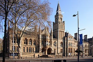
Friern Barnet Town Hall is a municipal building in Friern Barnet Lane in Friern Barnet, London, England. The building, which was the headquarters of Friern Barnet Urban District Council from 1941 to 1965, is a Grade II listed building.

References

  1. 1 2 3 4 "Finchley: Local government". A History of the County of Middlesex: Volume 6: Friern Barnet, Finchley, Hornsey with Highgate. British History Online. 1980. Retrieved 28 April 2009.
  2. "No. 33809". The London Gazette . 18 March 1932. p. 1853.
  3. "The New Borough Of Finchley. Lord Athlone's Visit". The Times . 6 October 1933. p. 9.
  4. Historic England. "Grandstand at Summers Lane sports ground (1416297)". National Heritage List for England . Retrieved 27 April 2020.
  5. "The Borough Elections". The Times . 3 November 1937. p. 19.
  6. "The Municipal Elections". The Times . 2 November 1938.
  7. "The Municipal Elections". The Times . 3 November 1945. p. 2.
  8. "The Municipal Elections". The Times . 13 May 1949. p. 3.
  9. "The Municipal Elections". The Times . 12 May 1950. p. 4.
  10. "The Municipal Elections". The Times . 5 May 1956. p. 5.
  11. "The Municipal Elections". The Times . 10 May 1957. p. 6.
  12. "Election Results in the Boroughs". The Times . 10 May 1963.
  13. "Middlesex". Civic Heraldry of England and Wales. Retrieved 5 May 2009.
  14. Scott-Giles, C Wilfrid (1953). Civic Heraldry of England and Wales, 2nd edition. London: J M Dent & Sons. pp. 270–271.
  15. Godleman, Mike (4 July 2007). "Town twinning Jinja (Uganda)". LB Barnet. Archived from the original on 20 August 2008. Retrieved 28 April 2009.
  16. Costello, Laura (28 July 2008). "Town twinning Le Raincy (France)". LB Barnet. Archived from the original on 21 August 2008. Retrieved 28 April 2009.
  17. Costello, Laura (29 July 2008). "Town twinning Montclair (USA)". LB Barnet. Archived from the original on 21 August 2008. Retrieved 28 April 2009.
  18. Godleman, Mike (28 July 2008). "Town twinning Siegen Wittgenstein (Germany)". LB Barnet. Archived from the original on 4 September 2008. Retrieved 28 April 2009.

Kelly's directories

These contain lists of residents for Finchley and interesting descriptions of the area.

Coordinates: 51°36′N0°11′W / 51.60°N 0.18°W / 51.60; -0.18