
Deptford is an area on the south bank of the River Thames in southeast London, within the London Borough of Lewisham. It is named after a ford of the River Ravensbourne. From the mid 16th century to the late 19th it was home to Deptford Dockyard, the first of the Royal Dockyards. This was a major shipbuilding dock and attracted Peter the Great to come and study shipbuilding. Deptford and the docks are associated with the knighting of Sir Francis Drake by Queen Elizabeth I aboard the Golden Hind, the legend of Sir Walter Raleigh laying down his cape for Elizabeth, Captain James Cook's third voyage aboard HMS Resolution, and the mysterious apparent murder of Christopher Marlowe in a house along Deptford Strand.

Lewisham is a London borough in south-east London; it forms part of Inner London. The principal settlement of the borough is Lewisham. The local authority is Lewisham London Borough Council, based in Catford. The Prime Meridian passes through Lewisham. Blackheath, Goldsmiths, University of London and Millwall F.C. are located within the borough.

Camberwell was a civil parish and metropolitan borough in south London, England. Camberwell was an ancient parish in the county of Surrey, governed by an administrative vestry from 1674. The parish was included in the area of responsibility of the Metropolitan Board of Works in 1855 and became part of the County of London in 1889. The parish of Camberwell became a metropolitan borough in 1900, following the London Government Act 1899, with the parish vestry replaced by a borough council. In 1965 the borough was abolished and its former area became part of the London Borough of Southwark in Greater London.

The County of London was a county of England from 1889 to 1965, corresponding to the area known today as Inner London. It was created as part of the general introduction of elected county government in England, by way of the Local Government Act 1888. The Act created an administrative County of London, which included within its territory the City of London. However, the City of London and the County of London formed separate ceremonial counties for "non-administrative" purposes. The local authority for the county was the London County Council (LCC), which initially performed only a limited range of functions, but gained further powers during its 76-year existence. The LCC provided very few services within the City of London, where the ancient Corporation monopolised local governance. In 1900, the lower-tier civil parishes and district boards were replaced with 28 new metropolitan boroughs. The territory of the county was 74,903 acres (303.12 km2) in 1961. During its existence, there was a long-term decline in population as more residents moved into the outer suburbs; there were periodic reviews of the local government structures in the greater London area and several failed attempts to expand the boundaries of the county. In 1965, the London Government Act 1963 replaced the county with the much larger Greater London administrative area.

Lambeth was a civil parish and metropolitan borough in south London, England. It was an ancient parish in the county of Surrey. The parish was included in the area of responsibility of the Metropolitan Board of Works in 1855 and became part of the County of London in 1889. The parish of Lambeth became a metropolitan borough in 1900, following the London Government Act 1899, with the parish vestry replaced by a borough council.

The River Ravensbourne is a tributary of the River Thames in south London, England. It flows into the tidal River Thames at Deptford, where its tidal reach is known as Deptford Creek.

St Pancras was a civil parish and metropolitan borough in London, England. It was an ancient parish in the county of Middlesex, governed by an administrative vestry. The parish was included in the area of responsibility of the Metropolitan Board of Works in 1855 and became part of the County of London in 1889. The parish of St Pancras became a metropolitan borough in 1900, following the London Government Act 1899, with the parish vestry replaced by a borough council. In 1965 the borough was abolished and its former area became part of the London Borough of Camden in Greater London.

The Metropolitan Borough of Lewisham was a metropolitan borough in the County of London between 1900 and 1965, when it became part of the London Borough of Lewisham along with the Metropolitan Borough of Deptford.

The Metropolitan Borough of Greenwich was a metropolitan borough in the County of London between 1900 and 1965. It bordered the boroughs of Woolwich, Lewisham and Deptford and, across the River Thames, the borough of Poplar and the County Borough of West Ham in Essex. Within the area of the borough were the Royal Naval College, the Royal Observatory and Greenwich Park.

The Metropolitan Borough of Woolwich was a metropolitan borough in the County of London from 1900 to 1965. It was formed from the civil parishes of Eltham, Plumstead and Woolwich. Its former area is now part of the Royal Borough of Greenwich and the London Borough of Newham.

Battersea was a civil parish and metropolitan borough in the County of London, England. In 1965, the borough was abolished and its area combined with parts of the Metropolitan Borough of Wandsworth to form the London Borough of Wandsworth. The borough was administered from Battersea Town Hall on Lavender Hill. That building is now Battersea Arts Centre.

Poplar was a local government district in the metropolitan area of London, England. It was formed as a district of the Metropolis in 1855 and became a metropolitan borough in the County of London in 1900. It comprised Poplar, Millwall, Bromley-by-Bow and Bow as well as Old Ford, Fish Island and Cubitt Town.

The Metropolitan Borough of Stoke Newington was a metropolitan borough in the County of London between 1900 and 1965 when it became part of the London Borough of Hackney.

The region of Greater London, including the City of London, is divided into 73 parliamentary constituencies which are sub-classified as borough constituencies, affecting the type of electoral officer and level of expenses permitted.
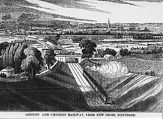
Hatcham was a manor and later a chapelry in what is now London, England. It largely corresponds to the area around New Cross in the London Borough of Lewisham.
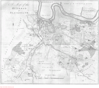
Blackheath was an ancient hundred in the north west of the county of Kent in England. It had become obsolete by the beginning of the 20th century in the wake of ongoing reforms to local government. The name "Blackheath" now refers to a district of SE London. In 2022, the area of the old hundred lies mainly within the Royal Borough of Greenwich.
Deptford is an area in the London Borough of Lewisham and London Borough of Greenwich.
Plumstead (1855–1894) and then Lee (1894–1900) was a local government district within the metropolitan area of London from 1855 to 1900. It was formed as the Plumstead district by the Metropolis Management Act 1855 and was governed by the Plumstead District Board of Works, which consisted of elected vestrymen.
Greenwich was a local government district within the metropolitan area of London, England from 1855 to 1900. It was formed by the Metropolis Management Act 1855 and was governed by the Greenwich District Board of Works, which consisted of elected vestrymen.

Deptford St Nicholas was a civil parish in the metropolitan area of London, England. The creation of the parish accompanied the building of the Church of St Paul's, Deptford, constructed by the Commission for Building Fifty New Churches to meet the demands of the growing population. The ancient parish of Deptford was split in 1730 with the southern part around the new church becoming Deptford St Paul. St Nicholas parish included the old maritime settlement and the dockyard adjacent to the River Thames. Civil parish administration was in the hands of the vestry until 1855 when the parish was grouped into the Greenwich District and the parish elected vestrymen to Greenwich District Board of Works. The parish was transferred from the County of Kent to the County of London in 1889. It became part of the Metropolitan Borough of Greenwich in 1900 and the local authority became Greenwich Borough Council. The civil parish had only nominal existence until 1930 when it was abolished. The area became part of the London Borough of Greenwich in 1965 and following boundary changes in 1994, part of the former parish is now in the London Borough of Lewisham.


 Map of borough boundary


