A blizzard is a severe snowstorm characterized by strong sustained winds and low visibility, lasting for a prolonged period of time—typically at least three or four hours. A ground blizzard is a weather condition where snow is not falling but loose snow on the ground is lifted and blown by strong winds. Blizzards can have an immense size and usually stretch to hundreds or thousands of kilometres.

The Great Appalachian Storm of November 1950 was a large extratropical cyclone which moved through the Eastern United States, causing blizzard conditions along the western slopes of the Appalachian Mountains and significant winds and heavy rainfall east of the mountains. Hurricane-force winds, peaking at 110 miles per hour (180 km/h) in Concord, New Hampshire, and 160 mph (260 km/h) in the highlands of New England, disrupted power to 1 million customers during the event.
The New Year's Eve 1963 snowstorm was a significant winter storm occurring from December 31, 1963 to January 1, 1964 over most of the Southern United States. The storm began when a surface low-pressure system moved northward through the eastern Gulf of Mexico and up the Fall Line east of the Appalachians, leading to a snowstorm from the central Gulf coast northward into Tennessee. Three people perished during the storm, and travel was severely restricted for a couple of days following the snowfall. The strong winds accompanied by heavy snow fall set historic new snowfall records in Alabama.

The December 2009 North American blizzard was a powerful nor'easter that formed over the Gulf of Mexico in December 2009, and became a major snowstorm that affected the East Coast of the United States and Canadian Atlantic provinces. The snowstorm brought record-breaking December snowfall totals to Washington, D.C., Baltimore, and Philadelphia.
The February 1995 nor'easter was a significant nor'easter that impacted the Mid-Atlantic and New England regions of the United States around the beginning of the month. It was the only major nor'easter of the 1994–1995 winter.
The February 1987 nor'easter was a significant winter storm in the US that impacted the Mid-Atlantic States around the end of the month. It delivered 8–12 hours of heavy, wet snowfall to several states from West Virginia to New York between February 22 and February 24. The storm was both preceded and followed by relatively warm temperatures, causing the snow to rapidly melt. The mild conditions were the result of a moderate anticyclone over the region that deteriorated as the nor'easter approached. Cold air damming likely took place prior to the storm's formation.

The February 1969 nor'easter was a severe winter storm that affected the Mid-Atlantic and New England regions of the United States between February 8 and February 10. The nor'easter dropped paralyzing snowfall, exceeding 20 in (51 cm) in many places. New York City bore the brunt of the storm, suffering extensive disruption. Thousands of travelers became stranded on roads and in airports. The storm killed at least 94 people. City schools were closed for several days and some areas of the city remained uncleared for over a week. New York Mayor John Lindsay was criticized for failing to respond to the snowstorm adequately.

The March 18–20, 1956 nor'easter was a significant winter storm in the United States that affected the Mid-Atlantic States and southern New England. The storm ranked as Category 1, or "notable", on the Northeast Snowfall Impact Scale. A high-pressure area north of New York State, developing in the wake of another system on March 15–16, provided cold air for the snowfall. It was among a series of snowstorms to affect the region during the month.

The March 18–22, 1958 nor'easter was an unusual late-season and violent winter storm that impacted the Mid-Atlantic and New England regions of the United States. Its snowfall extended from North Carolina through Maine.

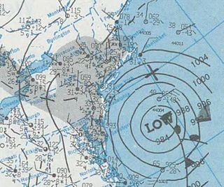
The February 9–10, 2010 North American blizzard was a winter and severe weather event that afflicted the Midwest, Mid-Atlantic and New England regions of the United States between February 9–11, 2010, affecting some of the same regions that had experienced a historic Nor'easter three days prior. The storm brought 10 to 20 inches of snow across a wide swath from Washington, DC to New York City, with parts of the Baltimore metro area receiving more than 20 inches (51 cm). This storm began as a classic "Alberta clipper", starting out in Canada and then moving southeast, and finally curving northeast while rapidly intensifying off the New Jersey coast, forming an eye. The National Weather Service, in an interview with The Baltimore Sun's weather reporter Frank Roylance, likened this storm to a Category 1 hurricane. Forecasters told Roylance that "Winds topped 58 mph over part of the Chesapeake Bay, and 40 mph gusts were common across the region as the storm's center deepened and drifted slowly along the mid-Atlantic coast". This storm system, in conjunction with the first storm 3 days prior, has been nicknamed Snoverkill.

The January 1961 nor'easter was a significant winter storm that impacted the Mid-Atlantic and New England regions of the United States. It was the second of three major snowstorms during the 1960–1961 winter. The storm ranked as Category 3, or "major", on the Northeast Snowfall Impact Scale.

The effects of Hurricane Floyd in New England stretched across the region from Connecticut to Maine and included two casualties. Floyd, once a large and powerful hurricane, made landfall in North Carolina and weakened as it tracked northward along the U.S. East Coast. By September 17, 1999, the storm, downgraded in strength to a tropical storm, was situated over New England. It produced heavy rainfall and gusty winds throughout the entire region, leading to widespread downing of trees and extensive power outages before it moved away later that day. In Danbury, Connecticut, Floyd triggered severe flooding, considered the worst in 40 years, that damaged hundreds of homes. Precipitation in some areas amounted to 10 in (250 mm), with wind gusts approaching hurricane force in Massachusetts. Damage totaled $4.819 million.

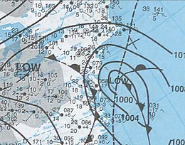
The December 1960 nor'easter was a significant early-season winter storm that impacted the Mid-Atlantic and New England regions of the United States. Moderate to heavy snowfall fell from West Virginia to eastern Maine, amounting to 10 in (25 cm) or more in parts of 13 states and peaking at 21.4 in (54 cm) at Newark, New Jersey. The storm was accompanied by strong winds, gusting to over 90 mph (140 km/h) in coastal New England, and left in its wake a dangerously cold air mass. The storm originated in a weak low pressure area which formed over the western Gulf of Mexico on December 10. A secondary low developed over South Carolina on the next day, supported by the merger of two troughs aloft. Sliding southeast of New England, the new storm explosively deepened to become a full-fledged nor'easter, with a minimum central air pressure of 966 mbar. It began to weaken over the Canadian Maritimes.

The March 1960 nor'easter was a severe winter storm that impacted the Mid-Atlantic and New England regions of the United States. The storm ranked as Category 4, or "crippling", on the Northeast Snowfall Impact Scale. Northeasterly flow, combined with the storm's slower forward motion, enhanced snowfall across the region. The cyclone began moving away from the United States on March 5. It took place during a stormy period in the affected region, contributing to record snowfall.

The December 1969 nor'easter was a strong winter storm that mainly affected the Northeastern United States and southern Quebec between December 25 and December 28, 1969. The multi-faceted storm system included a tornado outbreak, record snow accumulations, a damaging ice storm, and flooding rains.

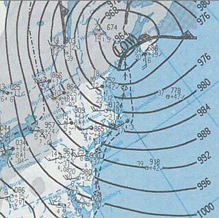
The December 1992 nor'easter produced record high tides and snowfall across the northeastern United States. It developed as a low pressure area on December 10 over Virginia, and for two days it remained over the Mid-Atlantic states before moving offshore. In Maryland, the snowfall unofficially reached 48 in (1,200 mm); if verified, the total would have been the highest in the state's history. About 120,000 people were left without power in the state due to high winds. Along the Maryland coast, the storm was less severe than the Perfect Storm in the previous year, although the strongest portion of the storm remained over New Jersey for several days. In the state, winds reached 80 mph (130 km/h) in Cape May, and tides peaked at 10.4 ft (3.2 m) in Perth Amboy. The combination of high tides and 25 ft (7.6 m) waves caused the most significant flooding in the state since the Ash Wednesday Storm of 1962. Several highways and portions of the New York City Subway and Port Authority Trans-Hudson systems were closed due to the storm. Throughout New Jersey, the nor'easter damaged about 3,200 homes and caused an estimated $750 million in damage (1992 USD).

The 2012–13 North American winter started out somewhat early, as the remnants of Hurricane Sandy brought heavy snow to the mountains of West Virginia in late October. Later, a strong nor'easter affected the weary Northeastern United States, hampering storm recovery efforts and dropping several inches of snow. The rest of the winter featured several other notable events, such as a Christmas winter storm that affected most of the Eastern United States, and the most notable event occurring in early February, when a powerful blizzard struck the Northeast and brought record snow to some areas. During the winter, a weak El Nino was expected to influence weather conditions across the continent.

The 2011–12 North American winter by and large saw above normal average temperatures across North America, with the Contiguous United States encountering its fourth-warmest winter on record, along with an unusually low number of significant winter precipitation events. The primary outlier was Alaska, parts of which experienced their coldest January on record.
The December 15–17, 2020 nor'easter was a powerful nor'easter that hammered the Northeastern United States and produced widespread swaths of over 1 foot (12 in) of snow in much of the region from December 15–17, 2020, ending a 1,000+ day high-impact snowstorm drought in much of the Mid-Atlantic and coastal New England regions. The system developed out of a weak area of low-pressure that first developed over the Central United States producing some snowfall before moving eastward, and by December 16, a new, dominant area of low pressure began to develop along the Southeast coast. This low steadily deepened as it moved along and impacted the Mid-Atlantic coastline, prompting several winter-related advisories and warnings for much of the Northeast.