List of census-designated places in Nebraska

Last updated
Map of the United States with Nebraska highlighted Nebraska in United States.svg
Map of the United States with Nebraska highlighted

This is a list of census-designated places in Nebraska. The United States Census Bureau defines census-designated places as unincorporated communities lacking elected municipal officers and boundaries with legal status. [1]

Contents

As of the 2020 census, Nebraska has 61 census-designated places, [2] up from 50 in the 2010 census. [3] Most CDPs in the state are small rural communities, although the list also includes a few bigger communities and suburbs. A total of 24,617 people live in Nebraska's CDPs, or 1,26% of the population.

Census-designated places

Name County Population
(2020) [4]
Area (2020) [2] Coordinates [2]
sq mikm2
Agnew Lancaster 300.1880.5 41°00′51″N96°48′51″W / 41.014234°N 96.81427°W / 41.014234; -96.81427
Ames Dodge 140.3290.9 41°26′54″N96°37′35″W / 41.448457°N 96.626339°W / 41.448457; -96.626339
Archer Merrick 681.0022.6 41°10′00″N98°08′20″W / 41.166629°N 98.138864°W / 41.166629; -98.138864
Aten Cedar 1341.6994.4 42°50′12″N97°26′27″W / 42.836736°N 97.44081°W / 42.836736; -97.44081
Beacon View Sarpy 550.4321.1 41°04′16″N96°19′35″W / 41.071193°N 96.326474°W / 41.071193; -96.326474
Belmar Keith 1994.58211.9 41°18′20″N101°56′05″W / 41.305457°N 101.934626°W / 41.305457; -101.934626
Berea Box Butte 491.1933.1 42°12′44″N102°58′59″W / 42.212279°N 102.982984°W / 42.212279; -102.982984
Bow Valley Cedar 950.1430.4 42°42′56″N97°15′08″W / 42.715424°N 97.252206°W / 42.715424; -97.252206
Brownlee Cherry 130.1060.3 42°17′21″N100°37′27″W / 42.289207°N 100.624178°W / 42.289207; -100.624178
Chalco Sarpy 11,0642.8177.3 41°10′54″N96°08′07″W / 41.181645°N 96.135367°W / 41.181645; -96.135367
Champion Chase 1150.2460.6 40°28′15″N101°44′42″W / 40.470854°N 101.744895°W / 40.470854; -101.744895
Cheney Lancaster 1640.1410.4 40°43′34″N96°35′37″W / 40.726041°N 96.593604°W / 40.726041; -96.593604
Emerald Lancaster 450.5891.5 40°48′47″N96°50′07″W / 40.81313°N 96.835371°W / 40.81313; -96.835371
Enders Chase 370.1310.3 40°27′18″N101°32′08″W / 40.454919°N 101.535567°W / 40.454919; -101.535567
Fontanelle Washington 670.2520.7 41°32′18″N96°25′38″W / 41.538255°N 96.427187°W / 41.538255; -96.427187
Glenwood Buffalo 5032.4016.2 40°45′20″N99°04′52″W / 40.755459°N 99.081007°W / 40.755459; -99.081007
Harrisburg Banner 996.46916.8 41°33′02″N103°43′36″W / 41.550529°N 103.726684°W / 41.550529; -103.726684
Holmesville Gage 600.2250.6 40°12′05″N96°39′32″W / 40.201426°N 96.65885°W / 40.201426; -96.65885
Inavale Webster 660.3340.9 40°05′32″N98°38′54″W / 40.092266°N 98.648391°W / 40.092266; -98.648391
Inland Clay 580.1690.4 40°35′43″N98°13′24″W / 40.595358°N 98.223235°W / 40.595358; -98.223235
Keystone Keith 730.2010.5 41°13′07″N101°35′03″W / 41.21874°N 101.584122°W / 41.21874; -101.584122
King Lake Douglas 1141.1112.9 41°18′35″N96°18′08″W / 41.309669°N 96.302285°W / 41.309669; -96.302285
Kramer Lancaster 260.471.2 40°35′29″N96°52′24″W / 40.591319°N 96.873283°W / 40.591319; -96.873283
Lakeview Platte 3780.611.6 41°29′59″N97°22′39″W / 41.499721°N 97.377516°W / 41.499721; -97.377516
La Platte Sarpy 500.3070.8 41°04′20″N95°55′35″W / 41.072261°N 95.926508°W / 41.072261; -95.926508
Lemoyne Keith 440.511.3 41°16′36″N101°48′48″W / 41.276644°N 101.813356°W / 41.276644; -101.813356
Lindy Knox 130.9982.6 42°44′06″N97°45′00″W / 42.735114°N 97.749951°W / 42.735114; -97.749951
Linoma Beach Sarpy 430.7161.9 41°03′26″N96°18′51″W / 41.057297°N 96.314066°W / 41.057297; -96.314066
Lisco Garden 680.5951.5 41°29′55″N102°37′25″W / 41.498669°N 102.623647°W / 41.498669; -102.623647
Lorenzo Cheyenne 366.83617.7 41°03′27″N103°04′56″W / 41.057574°N 103.082098°W / 41.057574; -103.082098
Loretto Boone 500.2810.7 41°45′48″N98°04′54″W / 41.763444°N 98.081721°W / 41.763444; -98.081721
Macy Thurston 1,0451.5954.1 42°06′57″N96°22′00″W / 42.115881°N 96.366599°W / 42.115881; -96.366599
Martell Lancaster 1250.1910.5 40°38′20″N96°45′32″W / 40.638942°N 96.758794°W / 40.638942; -96.758794
Martin Keith 760.3590.9 41°15′29″N101°42′32″W / 41.258135°N 101.709005°W / 41.258135; -101.709005
Max Dundy 500.2210.6 40°06′52″N101°24′16″W / 40.11432°N 101.404489°W / 40.11432; -101.404489
Melia Sarpy 981.443.7 41°05′50″N96°16′35″W / 41.097166°N 96.276438°W / 41.097166; -96.276438
Odessa Buffalo 1321.8244.7 40°41′57″N99°15′16″W / 40.699108°N 99.25441°W / 40.699108; -99.25441
Offutt Air Force Base Sarpy 5,3634.16910.8 41°07′16″N95°55′16″W / 41.120993°N 95.921108°W / 41.120993; -95.921108
Overland Hamilton 2021.3153.4 41°04′49″N97°58′44″W / 41.08024°N 97.978905°W / 41.08024; -97.978905
Parks Dundy 120.1760.5 40°02′37″N101°43′30″W / 40.04362°N 101.725113°W / 40.04362; -101.725113
Poole Buffalo 222.7517.1 40°59′32″N98°57′38″W / 40.992269°N 98.960594°W / 40.992269; -98.960594
Prairie Home Lancaster 380.4571.2 40°51′43″N96°31′28″W / 40.862006°N 96.524538°W / 40.862006; -96.524538
Princeton Lancaster 510.290.8 40°34′34″N96°42′21″W / 40.576029°N 96.70595°W / 40.576029; -96.70595
Raeville Boone 180.050.1 41°53′44″N98°03′13″W / 41.895582°N 98.053616°W / 41.895582; -98.053616
Richfield Sarpy 421.5113.9 41°06′39″N96°04′35″W / 41.110763°N 96.076324°W / 41.110763; -96.076324
Roscoe Keith 440.1570.4 41°07′54″N101°35′07″W / 41.131613°N 101.585195°W / 41.131613; -101.585195
St. Libory Howard 2410.3320.9 41°04′56″N98°21′33″W / 41.08214°N 98.359077°W / 41.08214; -98.359077
Sarben Keith 310.1570.4 41°09′59″N101°18′16″W / 41.166277°N 101.304402°W / 41.166277; -101.304402
Seneca Thomas 490.2950.8 42°02′38″N100°49′55″W / 42.043949°N 100.832055°W / 42.043949; -100.832055
Sunol Cheyenne 572.1895.7 41°09′15″N102°45′46″W / 41.154105°N 102.762746°W / 41.154105; -102.762746
Tamora Seward 440.9952.6 40°53′40″N97°13′46″W / 40.894442°N 97.22952°W / 40.894442; -97.22952
Tryon McPherson 1071.193.1 41°33′30″N100°57′13″W / 41.558444°N 100.953594°W / 41.558444; -100.953594
Venice Douglas 750.61.6 41°14′21″N96°21′07″W / 41.239266°N 96.351907°W / 41.239266; -96.351907
Walton Lancaster 3513.5629.2 40°47′45″N96°33′57″W / 40.795958°N 96.565763°W / 40.795958; -96.565763
Wann Saunders 1021.493.9 41°08′31″N96°21′51″W / 41.141891°N 96.364161°W / 41.141891; -96.364161
Westerville Custer 310.1310.3 41°23′46″N99°22′54″W / 41.396196°N 99.381796°W / 41.396196; -99.381796
Whiteclay [lower-alpha 1] Sheridan 80.0710.2 42°59′49″N102°33′18″W / 42.997019°N 102.555017°W / 42.997019; -102.555017
Willow Island Dawson 252.8147.3 40°53′24″N100°04′15″W / 40.890044°N 100.070711°W / 40.890044; -100.070711
Woodland Hills Otoe 2320.3660.9 40°45′06″N96°25′25″W / 40.751637°N 96.423603°W / 40.751637; -96.423603
Woodland Park Stanton 1,8301.5644.1 42°03′15″N97°20′43″W / 42.05424°N 97.345189°W / 42.05424; -97.345189
Yankee Hill Lancaster 2864.03910.5 40°45′55″N96°43′56″W / 40.765291°N 96.732217°W / 40.765291; -96.732217

See also

Notes

  1. Listed as "White Clay" by the United States Census Bureau.

Related Research Articles

A census-designated place (CDP) is a concentration of population defined by the United States Census Bureau for statistical purposes only. CDPs have been used in each decennial census since 1980 as the counterparts of incorporated places, such as self-governing cities, towns, and villages, for the purposes of gathering and correlating statistical data. CDPs are populated areas that generally include one officially designated but currently unincorporated community, for which the CDP is named, plus surrounding inhabited countryside of varying dimensions and, occasionally, other, smaller unincorporated communities as well. CDPs include small rural communities, edge cities, colonias located along the Mexico–United States border, and unincorporated resort and retirement communities and their environs.

Watersmeet, Michigan Census-designated place & unincorporated community in Michigan, United States

Watersmeet is an unincorporated community and census-designated place (CDP) in Watersmeet Township, Gogebic County, Michigan, in the United States. As of the 2010 census, the CDP had a population of 428, out of a total population in the township of 1,417. The community was platted in 1884, designated as a station of the Milwaukee Lake Shore and Western Railroad.

Wacousta, Michigan Census-designated place & unincorporated community in Michigan, United States

Wacousta is an unincorporated community and census-designated place (CDP) in Clinton County in the U.S. state of Michigan. The CDP is located within Watertown Charter Township. As of the 2010 census, it had a population of 1,440.

Rapid City, Michigan Census-designated place & unincorporated community in Michigan, United States

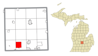
Rapid City is an unincorporated community and census-designated place (CDP) in Kalkaska County in the U.S. state of Michigan. At the 2010 census, the CDP had a population of 1,352. Rapid City is located within Clearwater Township.

Snyder, Colorado Census Designated Place in Colorado, United States

Snyder is an unincorporated town, a post office, and a census-designated place (CDP) located in and governed by Morgan County, Colorado, United States. The CDP is a part of the Fort Morgan, CO Micropolitan Statistical Area. The Snyder post office has the ZIP Code 80750. At the United States Census 2010, the population of the Snyder CDP was 132, while the population of the 80750 ZIP Code Tabulation Area was 412 including adjacent areas.

Laird, Colorado Census Designated Place in Colorado, United States

Laird is an unincorporated community and a census-designated place (CDP) located in and governed by Yuma County, Colorado, United States. The population of the Laird CDP was 47 at the United States Census 2010. The Wray post office (Zip Code 80758) serves Laird postal addresses. Laird has the lowest elevation of any community in Colorado at 3,402 feet (1,037 m).

Lakes of the North, Michigan Census-designated place & unincorporated community in Michigan, United States

Lakes of the North is an unincorporated community and census-designated place (CDP) in Antrim County in the U.S. state of Michigan. The CDP is located in Mancelona and Star townships. The population was 925 at the 2010 census.

Pilgrim, Michigan Census-designated place & unincorporated community in Michigan, United States

Pilgrim is an unincorporated community and census-designated place (CDP) in Benzie County in the U.S. state of Michigan. At the 2010 census, the CDP had a permanent population of 11. Pilgrim is located within Crystal Lake Township.

Poole, Nebraska Census-designated place in Nebraska, United States

Poole is a census-designated place (CDP) in Buffalo County, Nebraska, United States. It is part of the Kearney, Nebraska Micropolitan Statistical Area. The population of the CDP was 19 at the 2010 census.

Lake Victoria, Michigan Census-designated place & unincorporated community in Michigan, United States

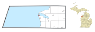
Lake Victoria is an unincorporated community and census-designated place (CDP) in Clinton County in the U.S. state of Michigan. It is located in Victor Township. As of the 2010 census, it had a population of 930.

Wedgewood, Michigan Census-designated place & unincorporated community in Michigan, United States

Wedgewood is an unincorporated community and census-designated place (CDP) in Wexford County in the U.S. state of Michigan. The population of the CDP was 237 as of the 2010 census. Wedgewood is located within Cherry Grove Township.

Manistee Lake, Michigan Census-designated place & unincorporated community in Michigan, United States

Manistee Lake is an unincorporated community and census-designated place (CDP) in Kalkaska County in the U.S. state of Michigan. At the 2010 census, the CDP had a population of 456. Manistee Lake is located within Coldsprings Township to the north and a small portion extending south into Excelsior Township.

Presque Isle Harbor, Michigan Census-designated place & unincorporated community in Michigan, United States

Presque Isle Harbor is an unincorporated community and census-designated place (CDP) in Presque Isle County in the U.S. state of Michigan. Its population was 600 as of the 2010 census. The CDP is located along the shores of Lake Huron within Presque Isle Township.

Meadow Oaks, Florida Unincorporated community in Florida, United States

Meadow Oaks is an unincorporated community and census-designated place (CDP) in Pasco County, Florida, United States. Located north of Florida State Road 52 inland from Hudson, it is within the Tampa–St. Petersburg–Clearwater Metropolitan Statistical Area (MSA) and the Southwest Florida Water Management District.

Swift Bird is a census-designated place (CDP) on the Cheyenne River Indian Reservation in Dewey County, South Dakota, United States. It was first listed as a CDP prior to the 2020 census. The population of the CDP was 117 at the 2020 census.

Sicangu is an unincorporated community and census-designated place (CDP) in Todd County, South Dakota, United States, within the Rosebud Indian Reservation. It was first listed as a CDP prior to the 2020 census. The population of the CDP was 276 at the 2020 census.

References

  1. "Geographic Terms and Concepts– Place". United States Census Bureau. United States Department of Commerce.
  2. 1 2 3 "Places: Nebraska". 2020 United States Census . United States Census Bureau . Retrieved January 22, 2022.
  3. "2010 Census Gazetteer Files". 2010 United States Census . United States Census Bureau . Retrieved January 22, 2022.
  4. "Explore Census Data". United States Census Bureau . Retrieved January 22, 2022.