List of census-designated places in Maine

Last updated

Map of the United States with Maine highlighted Maine in United States.svg
Map of the United States with Maine highlighted

This article lists incorporated places and census-designated places (CDPs) in the U.S. state of Maine . As of 2020, there were a total of 23 incorporated places in Maine, and 106 census-designated places, down from 109 during the 2010 Census. The CDPs of Sanford, South Sanford, and Springvale incorporated into the city of Sanford in 2013.

Contents

Incorporated Places

No.IP [1] PopulationCounty
1 Portland 68,408 Cumberland
2 Lewiston 37,121 Androscoggin
3 Bangor 31,753 Penobscot
4 South Portland 26,498Cumberland
5 Auburn 24,061Androscoggin
6 Biddeford 22,552 York
7 Sanford 21,982York
8 Westbrook 20,400Cumberland
9 Saco 20,381York
10 Augusta 18,899 Kennebec
11 Waterville 15,828Kennebec
12 Brewer 9,672Penobscot
13 Presque Isle 8,797 Aroostook
14 Bath 8,766 Sagadahoc
15 Ellsworth 8,399 Hancock
16 Old Town 7,431Penobscot
17 Caribou 7,396Aroostook
18 Belfast 6,938 Waldo
19 Rockland 6,936 Knox
20 Gardiner 5,961Kennebec
21 Calais 3,079 Washington
22 Hallowell 2,570Kennebec
23 Eastport 1,288Washington

Census-Designated Places

No.CDP [1] PopulationTownCounty
1 Brunswick 15,175 Brunswick Cumberland
2 Orono 9,474 Orono Penobscot
3 Old Orchard Beach 8,624 Old Orchard Beach York
4 Winslow 7,794 Winslow Kennebec
5 Gorham 6,882 Gorham Cumberland
6 Skowhegan 6,297 Skowhegan Somerset
7 Topsham 5,931 Topsham Sagadahoc
8 Yarmouth 5,869 Yarmouth Cumberland
9 Kennebunk 5,214 Kennebunk York
10 North Windham 4,904 Windham Cumberland
11 Houlton 4,856 Houlton Aroostook
12 Kittery 4,562 Kittery York
13 Millinocket 4,466 Millinocket Penobscot
14 Scarborough 4,403 Scarborough Cumberland
15 Hampden 4,343 Hampden Penobscot
16 Farmington 4,288 Farmington Franklin
17 Rumford 4,218 Rumford Oxford
18 Lisbon Falls 4,100 Lisbon Androscoggin
19 Camden 3,570 Camden Knox
20 South Eliot 3,550 Eliot York
21 Pittsfield 3,150 Pittsfield Somerset
22 Lake Arrowhead 3,071 Waterboro

Limerick

York
23 York Harbor 3,033 York York
24 Madawaska 2,967 Madawaska Aroostook
25 Bucksport 2,885 Bucksport Hancock
26 Lincoln 2,884 Lincoln Penobscot
27 Norway 2,748 Norway Oxford
28 Winthrop 2,650 Winthrop Kennebec
29 Fairfield 2,638 Fairfield Somerset
30 Madison 2,630 Madison Somerset
31 Oakland 2,602 Oakland Kennebec
32 Cape Neddick 2,568YorkYork
33 Bar Harbor 2,552 Bar Harbor Hancock
34 Dover-Foxcroft 2,528 Dover-Foxcroft Piscataquis
35 Cumberland Center 2,499 Cumberland Cumberland
36 Fort Kent 2,488 Fort Kent Aroostook
37 South Paris 2,267 Paris Oxford
38 Mechanic Falls 2,237 Mechanic Falls Androscoggin
39 Milford 2,233 Milford Penobscot
40 Wilton 2,198 Wilton Franklin
41 Berwick 2,187 Berwick York
42 Dexter 2,158 Dexter Penobscot
43 Bridgton 2,071BridgtonCumberland
44 Farmingdale 1,970FarmingdaleKennebec
45 Van Buren 1,937Van BurenAroostook
46 Thomaston 1,875ThomastonKnox
47 Falmouth 1,855FalmouthCumberland
48 Milo 1,847MiloPiscataquis
49 Fort Fairfield 1,825Fort FairfieldAroostook
50 Newport 1,776NewportPenobscot
51 Randolph 1,772RandolphKennebec
52 Richmond 1,760RichmondSagadahoc
53 Mexico 1,743MexicoOxford
54 Fryeburg 1,631FryeburgOxford
55 North Berwick 1,615North BerwickYork
56 Livermore Falls 1,594Livermore FallsAndroscoggin
57 East Millinocket 1,567East MillinocketPenobscot
58 Falmouth Foreside 1,511FalmouthCumberland
59 Freeport 1,485FreeportCumberland
60 Norridgewock 1,438NorridgewockSomerset
61 Clinton 1,419ClintonKennebec
62 Chisholm 1,380JayFranklin
63 South Windham 1,374WindhamCumberland
64 Winterport 1,340Winterport Waldo
65 Machias 1,274Machias Washington
66 Oxford 1,263OxfordOxford
67 Greenville 1,257GreenvillePiscataquis
68 Kennebunkport 1,238KennebunkportYork
69 Waldoboro 1,233Waldoboro Lincoln
70 West Kennebunk 1,176KennebunkYork
71 Damariscotta 1,142DamariscottaLincoln
72 Steep Falls 1,139StandishCumberland
73 Wiscasset 1,097WiscassetLincoln
74 Howland 1,096HowlandPenobscot
75 Boothbay Harbor 1,086Boothbay HarborLincoln
76 Dixfield 1,076DixfieldOxford
77 Limestone 1,075LimestoneAroostook
78 Castine 1,029CastineHancock
79 Kittery Point 1,012KitteryYork
80 Washburn 997WashburnAroostook
81 Searsport 992SearsportWaldo
82 Mars Hill 980Mars HillAroostook
83 Woodland 952BaileyvilleWashington
84 Blue Hill 943Blue HillHancock
85 Guilford 903GuilfordPiscataquis
86 Gray 884GrayCumberland
87 Hartland 813HartlandSomerset
88 Bingham 758BinghamSomerset
89 Anson 752AnsonSomerset
90 Bowdoinham 722BowdoinhamSagadahoc
91 Southwest Harbor 720Southwest HarborHancock
92 Ashland 709AshlandAroostook
93 Little Falls 708GorhamCumberland
94 Mapleton 683MapletonAroostook
95 Newcastle 667NewcastleLincoln
96 Eagle Lake 625Eagle LakeAroostook
97 Casco 587CascoCumberland
98 Brunswick Station 578BrunswickCumberland
99 Cousins Island 490YarmouthCumberland
100 Standish 469StandishCumberland
101 Unity 469UnityWaldo
102 Naples 428NaplesCumberland
103 Winter Harbor 426Winter HarborHancock
104 Lubec 349LubecWashington
105 Blaine 301BlaineAroostook
106 Littlejohn Island 118YarmouthCumberland

Related Research Articles

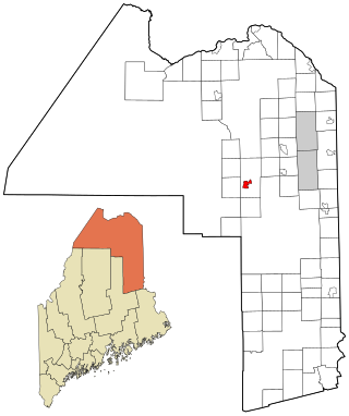
South Sanford is a former census-designated place (CDP) in the city of Sanford in York County, Maine, United States. The population was 4,536 at the 2010 census. It is part of the Portland–South Portland–Biddeford, Maine Metropolitan Statistical Area. The CDP was abolished when the town of Sanford re-incorporated as a city.

<span class="mw-page-title-main">Springvale, Maine</span> Place in Maine, United States

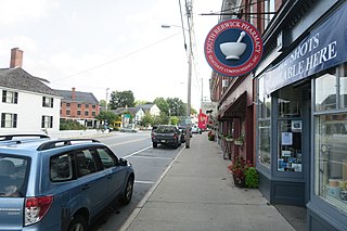
Springvale is a village and former census-designated place in the city of Sanford in York County, Maine, United States. The population was 3,292 at the 2010 census. It is part of the Portland–South Portland–Biddeford, Maine metropolitan statistical area. The CDP was abolished when the town of Sanford reincorporated as a city.

<span class="mw-page-title-main">Sanford (CDP), Maine</span> Census-designated place in Maine, United States

Sanford is a former census-designated place (CDP) comprising the downtown portion of the city of Sanford in York County, Maine, United States. The population of the CDP was 9,761 at the 2010 census. The CDP was abolished after the town of Sanford reincorporated as a city.

A census-designated place (CDP) is a concentration of population defined by the United States Census Bureau for statistical purposes only.

<span class="mw-page-title-main">New England town</span> Unit of government in New England, US

The town is the basic unit of local government and local division of state authority in the six New England states. Most other U.S. states lack a direct counterpart to the New England town. New England towns overlay the entire area of a state, similar to civil townships in other states where they exist, but they are fully functioning municipal corporations, possessing powers similar to cities and counties in other states. New Jersey's system of equally powerful townships, boroughs, towns, and cities is the system which is most similar to that of New England. New England towns are often governed by a town meeting, an assembly of eligible town residents. The great majority of municipal corporations in New England are based on the town model; there, statutory forms based on the concept of a compact populated place are uncommon, though elsewhere in the U.S. they are prevalent. County government in New England states is typically weak at best, and in some states nonexistent. Connecticut, for example, has no county governments, nor does Rhode Island. Both of those states retain counties only as geographic subdivisions with no governmental authority, while Massachusetts has abolished eight of fourteen county governments so far. Counties serve mostly as dividing lines for the states' judicial systems and some other state services in the southern New England states, while providing varying services in the more sparsely populated three northern New England states.

The United States Census Bureau defines a place as a concentration of population which has a name, is locally recognized, and is not part of any other place. A place typically has a residential nucleus and a closely spaced street pattern, and it frequently includes commercial property and other urban land uses. A place may be an incorporated place or it may be a census-designated place (CDP). Incorporated places are defined by the laws of the states in which they are contained. The Census Bureau delineates CDPs. A small settlement in the open countryside or the densely settled fringe of a large city may not be a place as defined by the Census Bureau. As of the census, 26% of the people in the United States lived outside of places.

<span class="mw-page-title-main">Sanford, Virginia</span> Census-designated place in Virginia, United States

Sanford is a census-designated place (CDP) in Accomack County, Virginia, United States. It was first listed as a CDP in 2010. Per the 2020 census, the population was 168.

<span class="mw-page-title-main">Sanford, Maine</span> City in Maine, United States

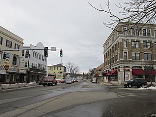
Sanford is a city in York County, Maine, United States. The population was 21,982 in the 2020 census, making it the seventh largest municipality in the state. Situated on the Mousam River, Sanford includes the village of Springvale. The city features many lakes in wooded areas which attract campers.

<span class="mw-page-title-main">Gray (CDP), Maine</span> Census-designated place in Maine, United States

Gray is a census-designated place (CDP) within the town of Gray, in Cumberland County, Maine, United States. The population was 884 at the 2010 census., comprising 11.4% of the town's population of 7,761.

<span class="mw-page-title-main">Little Falls, Maine</span> Census-designated place in Maine, United States

Little Falls is a census-designated place (CDP) in the town of Gorham in Cumberland County, Maine, United States. The population of the CDP was 708 at the 2010 census. Prior to 2010, Little Falls was part of the Little Falls-South Windham census-designated place.

<span class="mw-page-title-main">Littlejohn Island</span> Census-designated place in Maine, United States

Littlejohn Island is an island and census-designated place (CDP) in the town of Yarmouth in Cumberland County, Maine, United States. The population of the CDP was 118 at the 2010 census.

Horizon West is a census-designated place (CDP) and unincorporated area in Orange County, Florida, United States. It is part of the Orlando–Kissimmee–Sanford, Florida Metropolitan Statistical Area. The population was 58,101 at the 2020 census.

<span class="mw-page-title-main">Ashland (CDP), Maine</span> Census-designated place in Maine, United States

Ashland is a census-designated place (CDP) comprising the main village within the town of Ashland in Aroostook County, Maine, United States. The population of the CDP was 709 at the 2010 census, out of a population of 1,309 for the entire town.

<span class="mw-page-title-main">Mapleton (CDP), Maine</span> Census-designated place in Maine, United States

Mapleton is a census-designated place (CDP) comprising the main village within the town of Mapleton in Aroostook County, Maine, United States. The population of the CDP was 683 at the 2010 census, out of a population of 1,948 for the entire town.

<span class="mw-page-title-main">Washburn (CDP), Maine</span> Census-designated place in Maine, United States

Washburn is a census-designated place (CDP) comprising the main village within the town of Washburn in Aroostook County, Maine, United States. The population of the CDP was 997 at the 2010 census, out of a population of 1,687 for the entire town.

Alfred is a census-designated place (CDP) and the primary village in the town of Alfred, York County, Maine, United States. It is in central York County and the center of the town of Alfred, 4 miles (6 km) northeast of Sanford and 13 miles (21 km) west of Biddeford. U.S. Route 202 passes through the village, leading northeast 23 miles (37 km) to Gorham and southwest through Sanford 20 miles (32 km) to Rochester, New Hampshire. Maine State Route 4 leads south 13 miles (21 km) to North Berwick and leads north out of town with US 202. State Route 111 leads east from Alfred to Biddeford.

<span class="mw-page-title-main">South Berwick (CDP), Maine</span> Census-designated place in Maine, United States

South Berwick is a census-designated place (CDP) and the primary village in the town of South Berwick, York County, Maine, United States. It is in southwestern York County, in the northwestern corner of the town of South Berwick. It is bordered to the north by the town of Berwick, and to the southwest, across the Salmon Falls River, by the town of Rollinsford, New Hampshire.

References

  1. 1 2 "Maine: 2010 - Census Bureau" (PDF). United States Census Bureau.

See also