A census-designated place (CDP) is a concentration of population defined by the United States Census Bureau for statistical purposes only.

Pittsford is an unincorporated community and census-designated place (CDP) in Hillsdale County in the U.S. state of Michigan. The population of the CDP was 553 at the 2020 census. The community is located along M-34 on the border between Jefferson Township to the west and Pittsford Township to the east.
Menlo Park Terrace is an unincorporated community and census-designated place (CDP) and census-designated place located within Woodbridge Township in Middlesex County, in the U.S. state of New Jersey. It is located off U.S. Route 1 in between Menlo Park Mall and Woodbridge Center at Exit 130 of the Garden State Parkway.

Keasbey is a census-designated place (CDP) and unincorporated community located within Woodbridge Township, in Middlesex County, in the U.S. state of New Jersey. It is located in the western outskirts of adjacent Perth Amboy. As of the 2020 census, the CDP's population was 3,027. Many Hispanic / Latino families have relocated from Perth Amboy to Keasbey.
Sweetwater is an unincorporated community and census-designated place (CDP) located within Mullica Township in Atlantic County, in the U.S. state of New Jersey. The community is situated on the Mullica River about 20 miles (32 km) from Atlantic City.
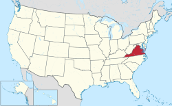
The following is a set–index article, providing a list of lists, for the cities, towns and villages within the jurisdictional United States. It is divided, alphabetically, according to the state, territory, or district name in which they are located.
Belva is an unincorporated community and census-designated place in west Nicholas County and north Fayette County, West Virginia, United States; while the CDP only includes the Nicholas County portion, the Fayette County portion is considered part of the community. The town is situated at the bottomland surrounding the convergence of Bells Creek with Twentymile Creek and, subsequently, Twenty Mile Creek with the Gauley River. Belva is also the location of the convergence of two state highways: West Virginia Route 16 and West Virginia Route 39.

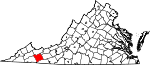
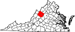
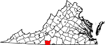
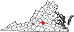
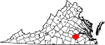
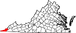
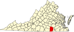
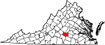
Boissevain is an unincorporated community, census-designated place (CDP), and former coal town in Tazewell County, Virginia, United States. It was defined as a census-designated place at the 1950 United States Census under the spelling Boissevaine, when it had a population of 1,197. It did not reappear again as a CDP until the 2020 census with a population of 457.
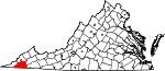
Locust Mount is an unincorporated community and census-designated place (CDP) in Accomack County, Virginia, United States. It was first listed as a CDP in the 2020 census with a population of 52. The CDP is in southeastern Accomack County, on the north side of Virginia State Route 180, which leads east 1.1 kilometres (0.7 mi) to Wachapreague and west 3.5 miles (5.6 km) to U.S. Route 13 at Keller.

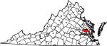
South Chesconessex is an unincorporated community and census-designated place (CDP) in Accomack County, Virginia, United States. The census uses the name Southside Chesconessex. It was first listed as a CDP in 2010. As of the 2020 census, it had a population of 115.
Absecon Highlands is an unincorporated community and census-designated place (CDP) in Atlantic County, in the U.S. state of New Jersey. It is in the eastern part of the county, in southern Galloway Township. It is bordered to the south by the city of Absecon and to the east by Reeds Bay, a tidal water body the connects to the Atlantic Ocean through Broad Creek and Absecon Inlet. The CDP includes the neighborhoods of Absecon Highlands, Seaview Estates, Seaview Park, Conovertown, and Holly Brook.
Virginia Lakes is an unincorporated community and census-designated place (CDP) in Mono County, California, United States. It is located on the eastern side of the Sierra Nevada in the area of the Virginia Lakes basin, at the southwest end of Virginia Lakes Road, which leads northeast 6 miles (10 km) to U.S. Route 395 at Conway Summit. The community was first listed as a CDP for the 2020 census, when it had a population of 7.
Marshallville is an unincorporated community and census-designated place (CDP) located in Upper Township, Cape May County, in the U.S. state of New Jersey. It is on the northern edge of the county, bordered to the north, across the Tuckahoe River, by Corbin City in Atlantic County. It is bordered to the east by the unincorporated community of Tuckahoe.
Ampere North is an unincorporated community and census-designated place (CDP) in Bloomfield Township, Essex County, in the U.S. state of New Jersey. It is in the southern corner of the township, bordered to the north by the Watsessing CDP, to the northeast by Silver Lake, to the southwest by East Orange, and to the southeast by Newark. Ampere Parkway runs through the center of the CDP, from Bloomfield Avenue at the northeast border of the community, south into the Ampere neighborhood in East Orange.
Bedminster is an unincorporated community and census-designated place (CDP) comprising the primary community in Bedminster Township, Somerset County, in the U.S. state of New Jersey. It was first listed as a CDP prior to the 2020 census.
West Dunbar is an unincorporated community and census-designated place (CDP) in Kanawha County, West Virginia, United States. As of the 2020 census, it had a population of 617.