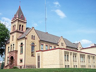
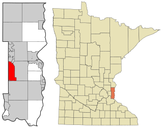
Kanabec County is a county in the East Central part of U.S. state of Minnesota. As of the 2020 United States Census, the population was 16,032. Its county seat is Mora.

Arnold is a former census-designated place (CDP), which was located in Rice Lake, Saint Louis County, Minnesota, United States. The population was 2,960 at the 2010 census. The census-designated place of Arnold was located entirely within the former Rice Lake Township, adjacent to the north side of the city of Duluth. Rice Lake Township was incorporated as the city of Rice Lake on October 22, 2015, thus rendering the census-designated place of Arnold to no longer exist.
Oakdale is a city in Washington County, Minnesota, United States. It is a suburb of Saint Paul and is on the eastern side of the Twin Cities Metropolitan area. The population was 27,378 at the 2010 census. Oakdale is the 32nd largest city in Minnesota by population.
A census-designated place (CDP) is a concentration of population defined by the United States Census Bureau for statistical purposes only. CDPs have been used in each decennial census since 1980 as the counterparts of incorporated places, such as self-governing cities, towns, and villages, for the purposes of gathering and correlating statistical data. CDPs are populated areas that generally include one officially designated but currently unincorporated community, for which the CDP is named, plus surrounding inhabited countryside of varying dimensions and, occasionally, other, smaller unincorporated communities as well. CDPs include small rural communities, edge cities, colonias located along the Mexico–United States border, and unincorporated resort and retirement communities and their environs.

Winchester, VA–WV MSA is a U.S. metropolitan statistical area (MSA) as defined by the United States Office of Management and Budget (OMB) as of June, 2003. This should not be confused with the City of Winchester, Virginia, the most populous community within this MSA. The population of the MSA as the 2015 U.S. Census Bureau estimates is 133,836.
Homer is an unincorporated community and census-designated place (CDP) in Homer Township, Winona County, Minnesota, United States, on the south bank of the Mississippi River. As of the 2010 census, its population was 181.

The Fort Smith Metropolitan Statistical Area, as defined by the United States Census Bureau, is a five-county area including three Arkansas counties and two Oklahoma counties, and anchored by the city of Fort Smith, Arkansas. The total MSA population in 2000 was 273,170 people, estimated by the Bureau to have grown to 289,693 people by 2007.

The Baton Rouge metropolitan statistical area, as defined by the United States Office of Management and Budget, or simply the Baton Rouge metropolitan area or Greater Baton Rouge, is a sprawling metropolitan statistical area surrounding the city of Baton Rouge. Its principal city Baton Rouge is unusual because it has no major incorporated satellite cities, a rarity for a metropolitan area of its size. Comprising the western edge of the Florida Parishes regions, it is known as "Plantation Country", the "Capital Region", and "The 225". At the 2010 U.S. census, the metropolitan area had a population of 802,484, up from 705,973 in 2000. At the 2020 census, its population increased to 870,569, up from 2020 estimates at 858,571.
The following is a set–index article, providing a list of lists, for the cities, towns and villages within the jurisdictional United States. It is divided, alphabetically, according to the state, territory, or district name in which they are located.

Finland is an unincorporated community and census-designated place (CDP) in Crystal Bay and Beaver Bay townships, Lake County, Minnesota, United States. As of the 2010 census, its population was 195.
Inger is an unincorporated community and census-designated place (CDP) in Itasca County, Minnesota, United States, along the Bowstring River of the Leech Lake Indian Reservation. As of the 2010 census, its population was 212.
Soudan is an unincorporated community and census-designated place (CDP) in Breitung Township, Saint Louis County, Minnesota, United States. As of the 2010 census, its population was 446.

The Brainerd Micropolitan Statistical Area, as defined by the United States Census Bureau, is an area consisting of Cass County and Crow Wing County in Northern Minnesota, anchored by the city of Brainerd. As of February 4, 2011 estimate placed the population at 91,067.
Bicycling has been a popular activity in Minnesota since the late 19th century. Since at least 2001, the state has claimed to have more miles of bike trails than any other in the U.S. For 2017, Minnesota was ranked as the 2nd most bicycle-friendly state by the League of American Bicyclists, moving up from its 5th-ranked position in 2008 and 2009. It was only exceeded by Washington. Much of the state's bicycle culture is centered in Minneapolis, the state's largest city, but the extensive network of trails has helped make cycling common throughout the state.

Fairhaven is an unincorporated community and census-designated place (CDP) in Fair Haven Township, Stearns County, Minnesota, United States. Its population was 358 as of the 2010 census.
Hubbard is an unincorporated community and census-designated place (CDP) in the western part of Hubbard Township, Hubbard County, Minnesota, United States. It is in southern Hubbard County, along Minnesota State Highway 87, at the outlet of Long Lake. Park Rapids is 8 miles (13 km) to the northwest.

