This article lists census-designated places (CDPs) in the U.S. state of New Hampshire . As of 2018, there were a total of 83 census-designated places in New Hampshire.
This article lists census-designated places (CDPs) in the U.S. state of New Hampshire . As of 2018, there were a total of 83 census-designated places in New Hampshire.

Hampshire County is a historical and judicial county located in the U.S. state of Massachusetts. Following the dissolution of the county government in 1999, county affairs were managed by the Hampshire Council of Governments, which itself ceased operations in 2019, due to a "fundamentally flawed, unsustainable operational model". As of the 2010 census, the population was 158,080. Its most populous municipality is Amherst, its largest town in terms of landmass is Belchertown, and its traditional county seat is Northampton. The county is named after the county Hampshire, in England.

Belmont is a town in Belknap County, New Hampshire, United States. The population was 7,356 at the 2010 census.

Bartlett is a town in Carroll County, New Hampshire, United States. The population was 2,788 at the 2010 census. Bartlett includes the unincorporated community of Glen as well as portions of the communities of Kearsarge and Intervale which the town shares with the neighboring town of Conway. It is set in the White Mountains and is surrounded by the White Mountain National Forest. It is home to the Attitash Mountain Resort and the Story Land theme park.
Walpole is a town in Cheshire County, New Hampshire, United States. The population was 3,734 at the 2010 census.

New London is a town in Merrimack County, New Hampshire, United States. The population was 4,397 at the 2010 census. The town is the home of Colby–Sawyer College.

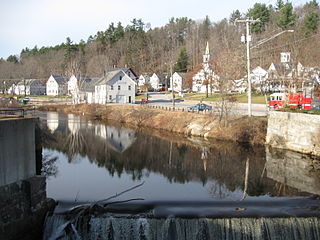
Suncook is a census-designated place (CDP) in Merrimack County, New Hampshire, United States. The population was 5,379 at the 2010 census. Approximately two-thirds of Suncook is located in the town of Pembroke, with the remainder in Allenstown.

Seabrook is a town in Rockingham County, New Hampshire, United States. The population was 8,693 at the 2010 census. Located at the southern end of the coast of New Hampshire on the border with Massachusetts, Seabrook is noted as the location of the Seabrook Nuclear Power Station, the third-most recently constructed nuclear power plant in the United States.

Marlborough is a town in Cheshire County, New Hampshire, United States. The population was 2,063 at the 2010 census. The town is home to the Kensan-Devan Wildlife Sanctuary at Meetinghouse Pond.
Antrim is a town in Hillsborough County, New Hampshire, United States. The population was 2,637 at the 2010 census. The primary settlement in the town, where 1,397 people lived at the 2010 census, is defined as the Antrim census-designated place (CDP) and is located at the intersection of U.S. Route 202 and New Hampshire Route 31. The town of Antrim also includes the villages of Antrim Center, North Branch, Clinton Village and South Village.

Hooksett is a town in Merrimack County, New Hampshire, United States. The population was 13,451 at the 2010 census and an estimated 14,428 in 2018. The town is located between Manchester, the state's largest city, and Concord, the state capital. A prominent landmark is Robie's Country Store, a National Historic Landmark and a frequent stop for presidential candidates during the New Hampshire primary.

Pittsfield is a town in Merrimack County, New Hampshire, United States. The population was 4,106 at the 2010 census.
A census-designated place (CDP) is a concentration of population defined by the United States Census Bureau for statistical purposes only. CDPs have been used in each decennial census since 1980 as the counterparts of incorporated places, such as self-governing cities, towns, and villages, for the purposes of gathering and correlating statistical data. CDPs are populated areas that generally include one officially designated but currently unincorporated community, for which the CDP is named, plus surrounding inhabited countryside of varying dimensions and, occasionally, other, smaller unincorporated communities as well. CDPs include small rural communities, edge cities, colonias located along the Mexico–United States border, and unincorporated resort and retirement communities and their environs.
Wilton is a town in Hillsborough County, New Hampshire, United States. The population was 3,677 at the 2010 census. Like many small New England towns it grew up around water-powered textile mills, but is now a rural bedroom community with some manufacturing and service employment. Wilton is home to the High Mowing School, a private preparatory school.
A minor civil division (MCD) is a term used by the United States Census Bureau for primary governmental and/or administrative divisions of a county, such as a civil township, precinct, or magisterial district. As of 2010, MCDs exist in 29 states and the District of Columbia. In New York and New England, they are towns. In Puerto Rico, the barrio or a barrio-pueblo is roughly comparable to an MCD.

Hillsborough, frequently spelled Hillsboro, is a town in Hillsborough County, New Hampshire, United States. The population was 6,011 at the 2010 census. The town is home to Fox State Forest and part of Low State Forest.

Winchester, VA–WV MSA is a U.S. metropolitan statistical area (MSA) as defined by the United States Office of Management and Budget (OMB) as of June, 2003. This should not be confused with the City of Winchester, Virginia, the most populous community within this MSA. The population of the MSA as the 2015 U.S. Census Bureau estimates is 133,836.

The town is the basic unit of local government and local division of state authority in the six New England states. Most other U.S. states lack a direct counterpart to the New England town. New England towns overlay the entire area of a state, similar to civil townships in other states where they exist, but they are fully functioning municipal corporations, possessing powers similar to cities in other states. New Jersey's system of equally powerful townships, boroughs, towns, and cities is the system which is most similar to that of New England. New England towns are often governed by a town meeting legislative body. The great majority of municipal corporations in New England are based on the town model; there, statutory forms based on the concept of a compact populated place are uncommon, though elsewhere in the U.S. they are prevalent. County government in New England states is typically weak at best, and in some states nonexistent. Connecticut, for example, has no county governments, nor does Rhode Island. Both of those states retain counties only as geographic subdivisions with no governmental authority, while Massachusetts has abolished eight of fourteen county governments so far. Counties serve mostly as dividing lines for the states' judicial systems in the southern New England states, while only providing limited services in the three northern New England states.
The following is a set–index article, providing a list of lists, for the cities, towns and villages within the jurisdictional United States. It is divided, alphabetically, according to the state, territory, or district name in which they are located.
The Berlin Micropolitan Statistical Area is the core-based statistical area centered on the urban cluster associated with the city Berlin, New Hampshire, in the United States. As defined by the Office of Management and Budget using counties as building blocks, the area consists of two counties – Coos County in New Hampshire, which contains the city of Berlin, and the adjacent Essex County in Vermont.

South Berwick is a census-designated place (CDP) and the primary village in the town of South Berwick, York County, Maine, United States. It is in southwestern York County, in the northwest corner of the town of South Berwick. It is bordered to the north by the town of Berwick, and to the southwest, across the Salmon Falls River, by the town of Rollinsford, New Hampshire.