Harrisburg, Nebraska

Last updated

Harrisburg, Nebraska
Harrisburg, Nebraska - Pennsylvania Ave.JPG
Downtown with Banner County Courthouse
Location within Banner County and Nebraska
Coordinates: 41°33′02″N103°43′36″W / 41.55056°N 103.72667°W / 41.55056; -103.72667
CountryUnited States
State Nebraska
County Banner
Area
[1]
  Total6.47 sq mi (16.76 km2)
  Land6.47 sq mi (16.76 km2)
  Water0.00 sq mi (0.00 km2)
Elevation
[2]
4,629 ft (1,411 m)
Population
 (2020)
  Total99
  Density15.30/sq mi (5.91/km2)
Time zone UTC−7 (Mountain (MST))
  Summer (DST) UTC−6 (MDT)
ZIP code
69345
Area code 308
FIPS code 31-21030 [3]
GNIS feature ID2393039 [2]
Website Harrisburg

Harrisburg is a rural small town in, and the county seat of, Banner County, Nebraska, United States. [4] The population was 100 at the 2010 census.

Contents

History

Harrisburg, and all of Banner County, were originally part of Cheyenne County and began with a homestead in 1884. A settlement, at first called Randall and then Centropolis, developed around this and neighboring homesteads. In November, 1888, Cheyenne County subdivided into five counties, and the settlement was included in the territory which became Banner County. Its county seat was originally located at Ashford, a few miles northeast. However, in 1889 Charles Schooley, a settler, donated part of his land for the development of a formal town. [5] A migrant being from Harrisburg, Pennsylvania caused the name to be selected. [6]

Because of its central location, Harrisburg became the home base for stagecoach and mail carrier lines in the county, and the county government moved its operations from Ashford in mid-1891. By 1892, Harrisburg had two hotels, two livery stables, a brickwork, a cheese factory, two banks and three newspapers. It was the principal community for the county, which was almost entirely devoted to wheat farming and cattle ranching. In 1951, oil (which had first been discovered in 1919) became the county's third commodity.[ citation needed ]

Harrisburg's fortunes rose and fell with the county's. The lack of a railroad line for shipping eventually drew the larger farm and ranch houses to the north, while the 1960s routing of Interstate Highway 80 through Kimball brought the removal of other businesses to the south. Other small hamlets in Banner County collapsed as people moved either north or south, or consolidated their activities around Harrisburg. This movement has allowed Harrisburg to flourish into the 21st century, despite its low resident population.[ citation needed ]

Geography

According to the United States Census Bureau, the CDP has a total area of 5.3 square miles (14 km2), all land.

Demographics

Historical population
CensusPop.Note
2020 99
U.S. Decennial Census [7]

Harrisburg is part of the Scottsbluff, Nebraska Micropolitan Statistical Area.

Harrisburg CDP

Harrisburg is also the locus of a census designated place (CDP) of the same name, established in 19__ by the United States Census Bureau. The Census Bureau has, since then, not tracked relevant data for the town alone, but only for the entirety of the population within the CDP boundaries. Pending establishment of a separate article about the CDP, this data is summarized below.

As of the census [3] of 2000, there were 75 people, 31 households, and 23 families residing in the CDP. The population density was 14.0 people per square mile (5.4/km2). There were 33 housing units at an average density of 6.2/sq mi (2.4/km2). The racial makeup of the CDP was 98.67% White, and 1.33% from two or more races. Hispanic or Latino of any race were 2.67% of the population.

There were 31 households, out of which 19.4% had children under the age of 18 living with them, 71.0% were married couples living together, 3.2% had a female householder with no husband present, and 22.6% were non-families. 16.1% of all households were made up of individuals, and 9.7% had someone living alone who was 65 years of age or older. The average household size was 2.42 and the average family size was 2.63.

In the CDP, the population was spread out, with 21.3% under the age of 18, 6.7% from 18 to 24, 14.7% from 25 to 44, 36.0% from 45 to 64, and 21.3% who were 65 years of age or older. The median age was 49 years. For every 100 females, there were 127.3 males. For every 100 females age 18 and over, there were 110.7 males.

The median income for a household in the CDP was $47,083, and the median income for a family was $50,625. Males had a median income of $43,750 versus $11,563 for females. The per capita income for the CDP was $19,992. There were no families and 2.7% of the population living below the poverty line, including no under eighteens and none of those over 64.

Climate

Climate data for Harrisburg, Nebraska (1981–2010)
MonthJanFebMarAprMayJunJulAugSepOctNovDecYear
Average high °F (°C)41.4
(5.2)
43.7
(6.5)
51.2
(10.7)
59.7
(15.4)
69.5
(20.8)
79.9
(26.6)
88.0
(31.1)
86.3
(30.2)
76.7
(24.8)
63.3
(17.4)
50.4
(10.2)
40.6
(4.8)
62.6
(17.0)
Average low °F (°C)14.1
(−9.9)
15.9
(−8.9)
22.6
(−5.2)
29.8
(−1.2)
40.0
(4.4)
49.1
(9.5)
55.2
(12.9)
53.4
(11.9)
42.6
(5.9)
30.4
(−0.9)
20.8
(−6.2)
13.1
(−10.5)
32.3
(0.2)
Average precipitation inches (mm)0.30
(7.6)
0.49
(12)
1.00
(25)
1.68
(43)
2.39
(61)
2.65
(67)
2.07
(53)
1.86
(47)
1.38
(35)
1.23
(31)
0.63
(16)
0.42
(11)
16.08
(408)
Average snowfall inches (cm)5.5
(14)
7.6
(19)
8.5
(22)
5.9
(15)
0.8
(2.0)
0.0
(0.0)
0.0
(0.0)
0.0
(0.0)
0.7
(1.8)
3.1
(7.9)
5.7
(14)
8.1
(21)
45.9
(117)
Source: NOAA [8]

See also

Related Research Articles

<span class="mw-page-title-main">Cheyenne County, Nebraska</span> County in Nebraska, United States

Cheyenne County is a county in the U.S. state of Nebraska. As of the 2020 United States Census, the population was 9,468. Its county seat is Sidney. The county was formed in 1871 and named for the Cheyenne Native American tribe.

<span class="mw-page-title-main">Banner County, Nebraska</span> County in Nebraska, United States

Banner County is a county in the western part of the U.S. state of Nebraska in the Great Plains region of the United States. As of the 2020 United States Census, its population was 674. Its county seat is the unincorporated community of Harrisburg; there are no incorporated municipalities within the county.

<span class="mw-page-title-main">Mojave Ranch Estates, Arizona</span> CDP in Mohave County, Arizona

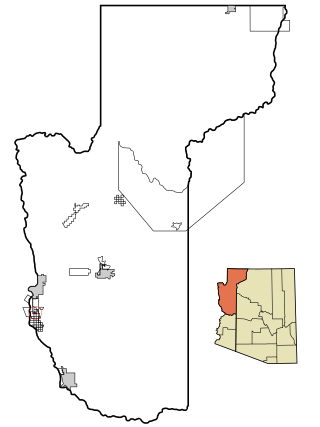
Mojave Ranch Estates is an unincorporated community and census-designated place (CDP) in Mohave County, Arizona, United States. The population was 53 as of the 2020 census.

<span class="mw-page-title-main">Three Points, Arizona</span> CDP in Arizona, United States

Three Points is a census-designated place (CDP) in Pima County, Arizona, United States. The population was 5,581 at the 2010 census.

<span class="mw-page-title-main">Tamalpais-Homestead Valley, California</span> Census-designated place in California, United States

Tamalpais-Homestead Valley is a census-designated place (CDP) in Marin County, California, United States. The population was 11,492 at the 2020 census.

<span class="mw-page-title-main">Homestead Base, Florida</span> Census-designated place in Florida, United States

Homestead Base is a census-designated place (CDP) in Miami-Dade County, Florida, United States. The population was 999 at the 2020 census. The CDP comprises the extent of Homestead Air Reserve Base plus some surrounding land.

<span class="mw-page-title-main">Wailuā Homesteads, Hawaii</span> Census-designated place in Hawaii, United States

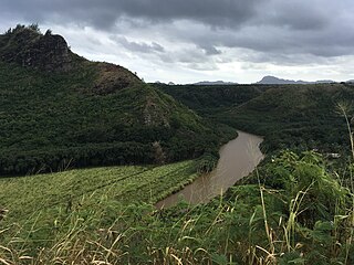
Wailua Homesteads is a census-designated place (CDP) in Kauaʻi County, Hawaiʻi, United States. The population was 5,863 at the 2020 census, up from 4,567 at the 2000 census.

<span class="mw-page-title-main">Vaughn, Montana</span> CDP in Montana, United States

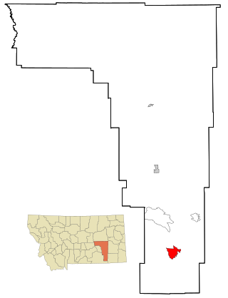
Vaughn is a census-designated place (CDP) in Cascade County, Montana, United States. The population was 658 at the 2010 census. It is part of the Great Falls, Montana Metropolitan Statistical Area. It is named for Montana pioneer Robert Vaughn, whose homestead on the Vaughn Ranch encompassed part of the town.

<span class="mw-page-title-main">Birney, Montana</span> Census-designated place in Montana, United States

Birney is a census-designated place (CDP) in Rosebud County, Montana, United States. The population was 108 at the 2000 census.

<span class="mw-page-title-main">Chalco, Nebraska</span> CDP in Nebraska, United States

Chalco is a census-designated place (CDP) in northern Sarpy County, Nebraska, United States, and an adjacent suburb of Omaha, with La Vista located to the southeast. The population was 11,064 at the 2020 census.

Lower Allen is a census-designated place (CDP) in Lower Allen Township in Cumberland County, Pennsylvania, United States. The population was 6,694 at the 2010 census. It is part of the Harrisburg–Carlisle metropolitan statistical area.

New Kingstown is a census-designated place (CDP) in Silver Spring Township, Cumberland County, Pennsylvania, United States. The population was 495 at the 2010 census. It is part of the Harrisburg–Carlisle metropolitan statistical area.

<span class="mw-page-title-main">Colonial Park, Pennsylvania</span> Census-designated place in Pennsylvania, United States

Colonial Park is an unincorporated community and census-designated place (CDP) in Lower Paxton Township, Pennsylvania, United States. The population was 13,229 at the 2010 census. It is part of the Harrisburg–Carlisle Metropolitan Statistical Area. It uses the Harrisburg ZIP code of 17109 and hosts a great deal of the area's retail activity, including the Colonial Park Mall.

<span class="mw-page-title-main">Lawnton, Pennsylvania</span> Census-designated place in Pennsylvania, United States

Lawnton is an unincorporated area and census-designated place (CDP) in Swatara Township, Dauphin County, Pennsylvania, United States. The population was 3,813 at the 2010 census. It is part of the Harrisburg–Carlisle Metropolitan Statistical Area.

<span class="mw-page-title-main">Paxtonia, Pennsylvania</span> Census-designated place in Pennsylvania, United States

Paxtonia is an unincorporated community and census-designated place (CDP) in Lower Paxton Township, Dauphin County, Pennsylvania, United States. The population was 5,412 at the 2010 census. It is part of the Harrisburg–Carlisle Metropolitan Statistical Area.

<span class="mw-page-title-main">Skyline View, Pennsylvania</span> Census-designated place in Pennsylvania, United States

Skyline View is an unincorporated community and census-designated place (CDP) in West Hanover Township, Dauphin County, Pennsylvania, United States. The population was 4,003 at the 2010 census, up from 2,307 at the 2000 census. It is part of the Harrisburg–Carlisle Metropolitan Statistical Area.

<span class="mw-page-title-main">Homestead Meadows South, Texas</span> Census-designated place in Texas, United States

Homestead Meadows South is a census-designated place (CDP) in El Paso County, Texas, United States. The population was 7,247 at the 2010 census. It is part of the El Paso Metropolitan Statistical Area. The ZIP Code encompassing the CDP area is 79938.

<span class="mw-page-title-main">Ashford, Washington</span> CDP in Washington, United States

Ashford is a census-designated place (CDP) mostly within Pierce County, Washington, United States. Its population was 217 as of the 2010 census. The town is west of the main entrance to Mount Rainier National Park. Surrounding mountains and the narrow Nisqually River valley are heavily forested. Some of Ashford is across the Nisqually River in Lewis County.

<span class="mw-page-title-main">Huntley, Wyoming</span> CDP in Wyoming, United States

Huntley is a census-designated place (CDP) in Goshen County, Wyoming, United States. The population was 30 according to the 2010 census.

Sweeney Ranch is an unincorporated community in Sweetwater County, Wyoming, United States. The population was 17 at the 2000 census, when it was a census-designated place (CDP).

References

  1. "ArcGIS REST Services Directory". United States Census Bureau. Retrieved 18 September 2022.
  2. 1 2 U.S. Geological Survey Geographic Names Information System: Harrisburg, Nebraska
  3. 1 2 "U.S. Census website". United States Census Bureau . Retrieved 31 January 2008.
  4. "Find a County". National Association of Counties. Retrieved 7 June 2011.
  5. "Harrisburg, Banner County". Center for Advanced Land Management Information Technologies. University of Nebraska. Retrieved 29 July 2014.
  6. Fitzpatrick, Lillian L. (1960). Nebraska Place-Names. University of Nebraska Press. p. 18. ISBN   0803250606.
  7. "Census of Population and Housing". Census.gov. Retrieved 4 June 2016.
  8. "NOWData - NOAA Online Weather Data". National Oceanic and Atmospheric Administration . Retrieved 5 May 2013.