Trenton, Nebraska

Last updated

Trenton, Nebraska
Trenton, Nebraska Main St from N 2.JPG
Trenton in 2013 (looking south)
Hitchcock County Nebraska Incorporated and Unincorporated areas Trenton Highlighted.svg
Location of Trenton, Nebraska
Coordinates: 40°10′29″N101°0′49″W / 40.17472°N 101.01361°W / 40.17472; -101.01361
Country United States
State Nebraska
County Hitchcock
Area
[1]
  Total0.58 sq mi (1.51 km2)
  Land0.58 sq mi (1.51 km2)
  Water0.00 sq mi (0.00 km2)
Elevation
[2]
2,674 ft (815 m)
Population
 (2020)
  Total516
  Density886.60/sq mi (342.09/km2)
Time zone UTC-6 (Central (CST))
  Summer (DST) UTC-5 (CDT)
ZIP code
69044
Area code 308
FIPS code 31-49145 [3]
GNIS feature ID2400002 [2]
Website villageoftrenton.net

Trenton is a village in Hitchcock County, Nebraska, United States. The population was 516 at the 2020 census. It is the county seat of Hitchcock County. [4]

Contents

History

Weyl Service Station in Trenton. Built in 1921, it is now part of the Hitchcock County Museum. It is listed in the National Register of Historic Places. Weyl service station from NE.JPG
Weyl Service Station in Trenton. Built in 1921, it is now part of the Hitchcock County Museum. It is listed in the National Register of Historic Places.

Trenton was platted in 1885 when the railroad was extended to that point. [6] It was named after Trenton, New Jersey. [7] [8] Due to Trenton's location near the center of the county, and its position on the Chicago, Burlington and Quincy Railroad, the seat of Hitchcock County was transferred there from the first county seat, Culbertson. [9]

Geography

According to the United States Census Bureau, the village has a total area of 0.58 square miles (1.50 km2), all land. [10]

Trenton Dam, impounding the Republican River, and its large reservoir called Lake Swanson, stand about two and one-half miles west of the city.

Climate

Climate data for Trenton Dam 1N, Nebraska (1991–2020 normals, extremes 1949–present)
MonthJanFebMarAprMayJunJulAugSepOctNovDecYear
Record high °F (°C)78
(26)
82
(28)
93
(34)
101
(38)
103
(39)
111
(44)
111
(44)
111
(44)
106
(41)
97
(36)
86
(30)
79
(26)
111
(44)
Mean daily maximum °F (°C)41.5
(5.3)
45.0
(7.2)
55.9
(13.3)
64.3
(17.9)
73.6
(23.1)
85.3
(29.6)
90.9
(32.7)
88.6
(31.4)
81.1
(27.3)
67.6
(19.8)
53.5
(11.9)
42.8
(6.0)
65.8
(18.8)
Daily mean °F (°C)28.3
(−2.1)
31.3
(−0.4)
41.2
(5.1)
50.2
(10.1)
60.3
(15.7)
71.6
(22.0)
77.1
(25.1)
75.1
(23.9)
66.4
(19.1)
52.6
(11.4)
39.4
(4.1)
29.7
(−1.3)
51.9
(11.1)
Mean daily minimum °F (°C)15.1
(−9.4)
17.6
(−8.0)
26.5
(−3.1)
36.1
(2.3)
47.0
(8.3)
58.0
(14.4)
63.3
(17.4)
61.6
(16.4)
51.8
(11.0)
37.7
(3.2)
25.4
(−3.7)
16.7
(−8.5)
38.1
(3.4)
Record low °F (°C)−24
(−31)
−24
(−31)
−25
(−32)
9
(−13)
23
(−5)
34
(1)
42
(6)
42
(6)
25
(−4)
2
(−17)
−16
(−27)
−31
(−35)
−31
(−35)
Average precipitation inches (mm)0.36
(9.1)
0.48
(12)
0.94
(24)
2.23
(57)
2.89
(73)
3.04
(77)
3.29
(84)
2.91
(74)
1.44
(37)
1.55
(39)
0.70
(18)
0.46
(12)
20.29
(515)
Average snowfall inches (cm)3.6
(9.1)
4.3
(11)
3.7
(9.4)
2.0
(5.1)
0.1
(0.25)
0.0
(0.0)
0.0
(0.0)
0.0
(0.0)
0.0
(0.0)
1.5
(3.8)
2.8
(7.1)
3.8
(9.7)
21.8
(55)
Average precipitation days (≥ 0.01 in)2.13.04.27.69.89.48.97.75.55.53.12.569.3
Average snowy days (≥ 0.1 in)1.72.31.71.00.00.00.00.00.00.51.11.910.2
Source: NOAA [11] [12]

Demographics

Historical population
CensusPop.Note
1890 267
1900 32923.2%
1910 49751.1%
1920 59219.1%
1930 86546.1%
1940 9206.4%
1950 1,23934.7%
1960 914−26.2%
1970 770−15.8%
1980 7963.4%
1990 656−17.6%
2000 507−22.7%
2010 56010.5%
2020 516−7.9%
U.S. Decennial Census

2010 census

As of the census [13] of 2010, there were 560 people, 264 households, and 134 families residing in the village. The population density was 965.5 inhabitants per square mile (372.8/km2). There were 328 housing units at an average density of 565.5 per square mile (218.3/km2). The racial makeup of the village was 98.4% White, 0.4% African American, 0.5% Native American, 0.4% from other races, and 0.4% from two or more races. Hispanic or Latino of any race were 1.6% of the population.

There were 264 households, of which 22.7% had children under the age of 18 living with them, 37.5% were married couples living together, 10.6% had a female householder with no husband present, 2.7% had a male householder with no wife present, and 49.2% were non-families. 43.9% of all households were made up of individuals, and 20.8% had someone living alone who was 65 years of age or older. The average household size was 2.02 and the average family size was 2.77.

The median age in the village was 48.1 years. 18.6% of residents were under the age of 18; 6.9% were between the ages of 18 and 24; 20.1% were from 25 to 44; 26.8% were from 45 to 64; and 27.7% were 65 years of age or older. The gender makeup of the village was 49.1% male and 50.9% female.

2000 census

As of the census [3] of 2000, there were 507 people, 246 households, and 138 families residing in the village. The population density was 878.7 inhabitants per square mile (339.3/km2). There were 301 housing units at an average density of 521.7 per square mile (201.4/km2). The racial makeup of the village was 98.62% White, 0.20% Asian, 0.59% from other races, and 0.59% from two or more races. Hispanic or Latino of any race were 1.18% of the population.

There were 246 households, out of which 19.5% had children under the age of 18 living with them, 46.3% were married couples living together, 6.9% had a female householder with no husband present, and 43.9% were non-families. 38.2% of all households were made up of individuals, and 18.7% had someone living alone who was 65 years of age or older. The average household size was 2.03 and the average family size was 2.70.

In the village, the population was spread out, with 17.8% under the age of 18, 6.9% from 18 to 24, 22.7% from 25 to 44, 27.8% from 45 to 64, and 24.9% who were 65 years of age or older. The median age was 47 years. For every 100 females, there were 92.8 males. For every 100 females age 18 and over, there were 87.8 males.

As of 2000 the median income for a household in the village was $25,078, and the median income for a family was $34,271. Males had a median income of $26,094 versus $20,625 for females. The per capita income for the village was $14,057. About 13.7% of families and 15.0% of the population were below the poverty line, including 12.8% of those under age 18 and 8.5% of those age 65 or over.

Notable person

See also

Related Research Articles

<span class="mw-page-title-main">Hitchcock County, Nebraska</span> County in Nebraska, United States

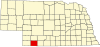
Hitchcock County is a county in the U.S. state of Nebraska. As of the 2020 United States Census, the population was 2,616. Its county seat is Trenton.

<span class="mw-page-title-main">Alvo, Nebraska</span> Village in Nebraska, United States

Alvo is a village in Cass County, Nebraska, United States. The population was 115 at the 2020 census.

<span class="mw-page-title-main">Manley, Nebraska</span> Village in Nebraska, United States

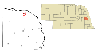
Manley is a village in Cass County, Nebraska, United States. The population was 167 at the 2020 census.

<span class="mw-page-title-main">Murdock, Nebraska</span> Village in Nebraska, United States

Murdock is a village in Cass County, Nebraska, United States. The population was 270 according to the 2020 census.

<span class="mw-page-title-main">Belden, Nebraska</span> Village in Nebraska, United States

Belden is a village in Cedar County, Nebraska, United States. The population was 112 at the 2020 census.

<span class="mw-page-title-main">St. Helena, Nebraska</span> Village in Nebraska, United States

St. Helena is a village in Cedar County, Nebraska, United States. The population was 91 at the 2020 census.

<span class="mw-page-title-main">Uehling, Nebraska</span> Village in Nebraska, United States

Uehling is a village in Dodge County, Nebraska, United States. The population was 230 at the 2010 census.

<span class="mw-page-title-main">Stockville, Nebraska</span> Village in and county seat of Frontier County, Nebraska, United States

Stockville is a village in Frontier County, Nebraska, United States. The population was 25 at the 2010 census. It is the county seat of Frontier County.

<span class="mw-page-title-main">Culbertson, Nebraska</span> Village in Hitchcock County, Nebraska, Untie States

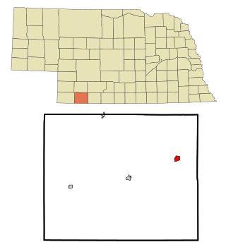
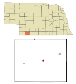
Culbertson is a village in Hitchcock County, Nebraska, United States. The population was 534 at the 2020 census.

<span class="mw-page-title-main">Stratton, Nebraska</span> Village in Hitchcock County, Nebraska, United States

Stratton is a village in Hitchcock County, Nebraska, United States. The population was 310 at the 2020 census.

<span class="mw-page-title-main">Chambers, Nebraska</span> Village in Nebraska, United States

Chambers is a village in Holt County, Nebraska, United States. The population was 268 at the 2010 census.

<span class="mw-page-title-main">Center, Nebraska</span> Village in and county seat of Knox County, Nebraska, United States

Center is a village in, and county seat of, Knox County, Nebraska, United States. The population was 73 at the 2020 census.

<span class="mw-page-title-main">Sutherland, Nebraska</span> Village in Nebraska, United States

Sutherland is a village in Lincoln County, Nebraska, United States. It is part of the North Platte, Nebraska Micropolitan Statistical Area. The population was 1,286 at the 2010 census.

<span class="mw-page-title-main">Unadilla, Nebraska</span> Village in Nebraska, United States

Unadilla is a village in Otoe County, Nebraska, United States. The population was 296 at the 2020 census.

<span class="mw-page-title-main">Indianola, Nebraska</span> Village in Red Willow County, Nebraska, US

Indianola is a village in Red Willow County, Nebraska, United States. The population was 584 at the 2010 census.

<span class="mw-page-title-main">Dorchester, Nebraska</span> Village in Nebraska, United States

Dorchester is a village in Saline County, Nebraska, United States. It is thirty-eight miles southwest from the Lincoln, Nebraska metropolitan area. The population was 596 at the 2020 census.

<span class="mw-page-title-main">Cedar Bluffs, Nebraska</span> Village in Saunders County, Nebraska, United States

Cedar Bluffs is a village in Saunders County, Nebraska, United States. The population was 615 at the 2020 census. Cedar Bluffs was a point on the Mormon, Oregon, and California Trails.

<span class="mw-page-title-main">Ithaca, Nebraska</span> Village in Saunders County, Nebraska, United States

Ithaca is a village in Saunders County, Nebraska, United States. The population was 160 at the 2020 census.

<span class="mw-page-title-main">Malmo, Nebraska</span> Village in Saunders County, Nebraska, United States

Malmo is a village in Saunders County, Nebraska, United States. The population was 94 at the 2020 census.

<span class="mw-page-title-main">Palisade, Nebraska</span> Village in Hitchcock and Hayes counties in Nebraska, United States

Palisade is a village in Hayes and Hitchcock counties in the U.S. state of Nebraska. The population was 294 at the 2020 census.

References

  1. "ArcGIS REST Services Directory". United States Census Bureau. Retrieved September 18, 2022.
  2. 1 2 U.S. Geological Survey Geographic Names Information System: Trenton, Nebraska
  3. 1 2 "U.S. Census website". United States Census Bureau . Retrieved January 31, 2008.
  4. "Find a County". National Association of Counties. Retrieved June 7, 2011.
  5. Stacy Stupka-Burda. "National Register of Historic Places Registration Form: Weyl Service Station". [usurped] Nebraska State Historical Society. [usurped] Retrieved April 6, 2013.
  6. "Trenton, Hitchcock County". Center for Advanced Land Management Information Technologies. University of Nebraska. Retrieved August 12, 2014.
  7. "Profile for Trenton, NE". ePodunk . Retrieved August 12, 2014.
  8. Fitzpatrick, Lillian L. (1960). Nebraska Place-Names. University of Nebraska Press. p. 74. ISBN   0-8032-5060-6. A 1925 edition is available for download at University of Nebraska—Lincoln Digital Commons.
  9. Burr, George L. (1921). History of Hamilton and Clay Counties, Nebraska, Volume 1. S.J. Clarke Publishing Company. p. 118.
  10. "US Gazetteer files 2010". United States Census Bureau. Archived from the original on January 25, 2012. Retrieved June 24, 2012.
  11. "NOWData - NOAA Online Weather Data". National Oceanic and Atmospheric Administration. Retrieved April 7, 2024.
  12. "Summary of Monthly Normals 1991-2020". National Oceanic and Atmospheric Administration. Retrieved April 7, 2024.
  13. "U.S. Census website". United States Census Bureau . Retrieved June 24, 2012.