St. Paul, Nebraska

Last updated

St. Paul, Nebraska
Saint Paul, Nebraska water tower 2.JPG
St. Paul water tower, with image of baseball player Grover Cleveland Alexander
Howard County Nebraska Incorporated and Unincorporated areas St. Paul Highlighted.svg
Location of St. Paul, Nebraska
Coordinates: 41°12′49″N98°27′34″W / 41.21361°N 98.45944°W / 41.21361; -98.45944
Country United States
State Nebraska
County Howard
Area
[1]
  Total1.24 sq mi (3.22 km2)
  Land1.24 sq mi (3.22 km2)
  Water0.00 sq mi (0.00 km2)
Elevation
[2]
1,811 ft (552 m)
Population
 (2020)
  Total2,416
  Density1,945.25/sq mi (750.98/km2)
Time zone UTC-6 (Central (CST))
  Summer (DST) UTC-5 (CDT)
Zip Code
68873
FIPS code 31-43265
GNIS feature ID2396515 [2]
Website http://www.stpaulnebraska.com/
Oblique air photo from September, 2018 St. Paul Nebraska September 2018.jpg
Oblique air photo from September, 2018

St. Paul or Saint Paul [2] is a city in and the county seat of Howard County, Nebraska, United States. [3] The population was 2,290 at the 2010 census.

Contents

St. Paul is part of the Grand Island, Nebraska Micropolitan Statistical Area.

History

St. Paul was founded by two young surveyors, James N. and Nicholas J. Paul, who had been surveying in Nebraska and the surrounding areas as the land opened to settlers. [4] Struck by the beauty and the prospects of the Loup valley, they took out homesteads, successfully petitioned the state legislature to form a new county to be known as Howard County, and laid out the townsite. They brought the first settlers to the county in March 1871 and established the seat of government in St. Paul. Stillman Hazeltine put up the first building for a general store and town hall in the summer of 1871. That first building burned a few years later and the brick building which replaced it is still in use with his name and date 1871 on the front.

When the town was to be named, a committee collected the suggested names in a hat and the name Athens was drawn. Since an Athens already existed in the state, Nebraska Senator Phineas W. Hitchcock suggested the name St. Paul in honor of the Paul brothers who founded it. It officially became the county seat by vote in 1874 and was incorporated in 1881. The first mayor was E.F. Clapp.[ citation needed ]

During its first twenty years, Howard County was a typical western frontier with covered wagons, cowboys, huge cattle herds, rowdy railroad construction gangs, and Army detachments stationed within its borders. As settlers and the railroad extended north and west, the town of St. Paul served as an important trade center and quickly grew to a population of 2,000 residents. From 1882 until 1917, St. Paul was the home of Frank Iams, the nation's largest importer of European draft horses. Three-star General C.S. Irvine set record-shattering, long-distance flights in a B-29 shortly after World War II. Herbert Paul was Adjutant General of the Nebraska National Guard for 19 years.[ citation needed ]

St. Paul had a broom factory, canning factory, brick factory, cigar factory, two flour mills, hatchery and more. Through the years innovation like the first self-rising flour was developed at one of the flour mills. The first chicken hatchery in Nebraska started in Cushing in 1901, moved to St. Paul in 1922, and operated until 1956. Pirus, a cure for many kidney and liver ailments, was invented in St. Paul. Dorothy Lynch invented her famous salad dressing in St. Paul, which is now sold nationally.[ citation needed ]

Grover Cleveland Alexander, who was inducted into the National Baseball Hall of Fame, was born on a farm in the area and retired to St. Paul at the end of his sports career. The American Legion baseball field was dedicated on June 15, 1971, and named after Alexander. Each year St. Paul honors Alexander with the celebration of Grover Cleveland Alexander (GCA) Days, the weekend following the 4th of July.[ citation needed ]

Geography

According to the United States Census Bureau, the city has a total area of 1.11 square miles (2.87 km2), all land. [5]

Climate

Climate data for St. Paul, Nebraska (1991–2020 normals, extremes 1899–2009)
MonthJanFebMarAprMayJunJulAugSepOctNovDecYear
Record high °F (°C)74
(23)
79
(26)
92
(33)
98
(37)
106
(41)
110
(43)
115
(46)
111
(44)
108
(42)
97
(36)
85
(29)
81
(27)
115
(46)
Mean maximum °F (°C)57.6
(14.2)
63.1
(17.3)
75.8
(24.3)
85.2
(29.6)
90.6
(32.6)
97.0
(36.1)
100.5
(38.1)
99.1
(37.3)
94.7
(34.8)
86.1
(30.1)
72.1
(22.3)
60.3
(15.7)
102.1
(38.9)
Average high °F (°C)35.4
(1.9)
40.9
(4.9)
54.0
(12.2)
64.9
(18.3)
73.9
(23.3)
84.3
(29.1)
88.8
(31.6)
86.6
(30.3)
80.0
(26.7)
66.5
(19.2)
50.1
(10.1)
38.0
(3.3)
63.6
(17.6)
Daily mean °F (°C)24.9
(−3.9)
29.4
(−1.4)
41.1
(5.1)
51.6
(10.9)
61.9
(16.6)
72.2
(22.3)
76.9
(24.9)
74.8
(23.8)
66.8
(19.3)
53.5
(11.9)
38.9
(3.8)
28.1
(−2.2)
51.7
(10.9)
Average low °F (°C)14.3
(−9.8)
18.0
(−7.8)
28.1
(−2.2)
38.2
(3.4)
49.9
(9.9)
60.0
(15.6)
65.0
(18.3)
63.0
(17.2)
53.6
(12.0)
40.4
(4.7)
27.7
(−2.4)
18.2
(−7.7)
39.7
(4.3)
Mean minimum °F (°C)−8.6
(−22.6)
−4.0
(−20.0)
7.4
(−13.7)
23.7
(−4.6)
35.2
(1.8)
46.9
(8.3)
53.6
(12.0)
50.9
(10.5)
36.1
(2.3)
24.8
(−4.0)
10.5
(−11.9)
−2.7
(−19.3)
−10.7
(−23.7)
Record low °F (°C)−33
(−36)
−32
(−36)
−17
(−27)
−2
(−19)
21
(−6)
34
(1)
42
(6)
36
(2)
22
(−6)
5
(−15)
−11
(−24)
−29
(−34)
−33
(−36)
Average precipitation inches (mm)0.55
(14)
0.70
(18)
1.57
(40)
2.73
(69)
4.47
(114)
4.01
(102)
3.47
(88)
3.47
(88)
2.13
(54)
2.18
(55)
1.18
(30)
0.86
(22)
27.32
(694)
Average snowfall inches (cm)4.7
(12)
6.2
(16)
3.0
(7.6)
1.8
(4.6)
0.0
(0.0)
0.0
(0.0)
0.0
(0.0)
0.0
(0.0)
0.0
(0.0)
0.4
(1.0)
2.2
(5.6)
4.1
(10)
22.4
(57)
Average precipitation days (≥ 0.01 in)3.84.86.28.610.99.68.88.26.36.74.24.082.1
Average snowy days (≥ 0.1 in)2.63.11.30.80.00.00.00.00.00.21.32.611.9
Source: NOAA (mean maxima/minima 18992009) [6] [7]

Demographics

Historical population
CensusPop.Note
1880 482
1890 1,263162.0%
1900 1,47516.8%
1910 1,336−9.4%
1920 1,61520.9%
1930 1,6210.4%
1940 1,571−3.1%
1950 1,6766.7%
1960 1,7142.3%
1970 2,02618.2%
1980 2,0943.4%
1990 2,009−4.1%
2000 2,21810.4%
2010 2,2903.2%
2020 2,4165.5%
U.S. Decennial Census [8]
2012 Estimate [9]

2010 census

As of the census [10] of 2010, there were 2,290 people, 989 households, and 590 families residing in the city. The population density was 2,063.1 inhabitants per square mile (796.6/km2). There were 1,093 housing units at an average density of 984.7 per square mile (380.2/km2). The racial makeup of the city was 98.1% White, 0.3% African American, 0.1% Native American, 0.1% Asian, and 1.3% from two or more races. Hispanic or Latino of any race were 1.4% of the population.

There were 989 households, of which 29.4% had children under the age of 18 living with them, 47.3% were married couples living together, 9.2% had a female householder with no husband present, 3.1% had a male householder with no wife present, and 40.3% were non-families. 36.1% of all households were made up of individuals, and 21.8% had someone living alone who was 65 years of age or older. The average household size was 2.28 and the average family size was 3.00.

The median age in the city was 40.3 years. 26% of residents were under the age of 18; 6% were between the ages of 18 and 24; 22.9% were from 25 to 44; 24% were from 45 to 64; and 21.1% were 65 years of age or older. The gender makeup of the city was 48.3% male and 51.7% female.

2000 census

As of the census of 2000, there were 2,218 people, 935 households, and 584 families residing in the city. The population density was 2,083.8 inhabitants per square mile (804.6/km2). There were 1,020 housing units at an average density of 958.3 per square mile (370.0/km2). The racial makeup of the city was 99.37% White, 0.23% African American, 0.18% Native American, 0.14% Asian, and 0.09% from two or more races. Hispanic or Latino of any race were 0.86% of the population.

There were 935 households, out of which 32.2% had children under the age of 18 living with them, 49.8% were married couples living together, 9.2% had a female householder with no husband present, and 37.5% were non-families. 34.4% of all households were made up of individuals, and 22.8% had someone living alone who was 65 years of age or older. The average household size was 2.33 and the average family size was 3.01.

In the city, the population was spread out, with 27.1% under the age of 18, 6.8% from 18 to 24, 24.0% from 25 to 44, 19.3% from 45 to 64, and 22.9% who were 65 years of age or older. The median age was 39 years. For every 100 females, there were 92.2 males. For every 100 females age 18 and over, there were 81.8 males.

As of 2000 the median income for a household in the city was $31,818, and the median income for a family was $43,571. Males had a median income of $32,051 versus $19,776 for females. The per capita income for the city was $17,596. About 5.8% of families and 8.3% of the population were below the poverty line, including 7.3% of those under age 18 and 17.2% of those age 65 or over.

Notable people

Related Research Articles

<span class="mw-page-title-main">Howard County, Nebraska</span> County in Nebraska, United States

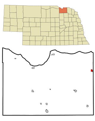
Howard County is a county in the state of Nebraska. As of the 2020 United States Census, the population was 6,475. Its county seat is St. Paul. The county was formed in 1871 and named after Civil War General Oliver Otis Howard.

<span class="mw-page-title-main">Elgin, Nebraska</span> City in Antelope County, Nebraska, United States

Elgin is a city in Antelope County, Nebraska, United States. The population was 661 at the 2010 census.

<span class="mw-page-title-main">Oakland, Nebraska</span> City in Nebraska, United States

Oakland is a city in Burt County, Nebraska, United States. The population was 1,244 at the 2010 census. Oakland continues to build on its strong foundation with its bi-annual Swedish Festival and is known by its proclamation from the Swedish Consul-General and the Governor of Nebraska as the "Swedish Capital of Nebraska." Oakland is also known as one of the more socially accepting towns in Nebraska. Each year, drag queens come from far and wide to showcase their culture at the Burt County Fair.

<span class="mw-page-title-main">Tekamah, Nebraska</span> City in Nebraska, United States

Tekamah is a city in Burt County, Nebraska, United States. The population was 1,736 at the 2010 census. It is the county seat of Burt County.

<span class="mw-page-title-main">Abie, Nebraska</span> Village in Nebraska, United States

Abie is a village in Butler County, Nebraska, United States. The population was 69 at the 2010 census.

<span class="mw-page-title-main">Obert, Nebraska</span> Village in Nebraska, United States

Obert is a village in Cedar County, Nebraska, United States. The population was 23 at the 2020 census.

<span class="mw-page-title-main">Harvard, Nebraska</span> City in Nebraska, United States

Harvard is a city in Clay County, Nebraska, United States. As of the 2010 census, the city population was 1,013. It is part of the Hastings micropolitan area.

<span class="mw-page-title-main">Maskell, Nebraska</span> Village in Dixon County, Nebraska, United States

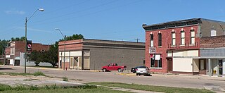
Maskell is a village in Dixon County, Nebraska, United States. It is part of the Sioux City, IA–NE–SD Metropolitan Statistical Area. The population was 76 at the 2010 census. It is reportedly home to the smallest city hall in the United States.

<span class="mw-page-title-main">Howard City, Nebraska</span> Village in Nebraska, United States

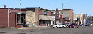
Howard City, locally referred to as Boelus, is a village in Howard County, Nebraska, United States. The population was 189 at the 2010 census. It is part of the Grand Island, Nebraska Micropolitan Statistical Area.

<span class="mw-page-title-main">Crofton, Nebraska</span> City in Nebraska, United States

Crofton is a city in Knox County, Nebraska, United States. The population was 726 at the 2010 census.

<span class="mw-page-title-main">Madison, Nebraska</span> City in Nebraska, United States

Madison is a city in and the county seat of Madison County, Nebraska, United States. The population was 2,283 at the 2020 census.

<span class="mw-page-title-main">Bassett, Nebraska</span> City in and county seat of Rock County, Nebraska, United States

Bassett is a city in Rock County, Nebraska, United States. The population was 619 at the 2010 census. It is the county seat of Rock County.

<span class="mw-page-title-main">Morse Bluff, Nebraska</span> Village in Saunders County, Nebraska, United States

Morse Bluff is a village in Saunders County, Nebraska, United States. The population was 117 at the 2020 census.

<span class="mw-page-title-main">Stanton, Nebraska</span> Village in and county seat of Stanton County, Nebraska, United States

Stanton is a city in Stanton County, Nebraska, United States. The population was 1,577 at the 2010 census. It is the county seat of Stanton County. Stanton was platted in 1870. Both the city and county are named after Edwin Stanton, secretary of war for president Abraham Lincoln during the American Civil War.

<span class="mw-page-title-main">Kennard, Nebraska</span> Village in Washington County, Nebraska, United States

Kennard is a village in Washington County, Nebraska, United States. The population was 361 at the 2010 census.

<span class="mw-page-title-main">Washington, Nebraska</span> Village in Washington County, Nebraska, United States

Washington is a village in Washington County, Nebraska, United States. The population was 150 at the 2010 census.

<span class="mw-page-title-main">Wayne, Nebraska</span> City in Wayne County, Nebraska, United States

Wayne is a city in Wayne County, Nebraska, United States. The population was 5,660 at the 2010 census. It is the county seat of Wayne County and the home of Wayne State College.

<span class="mw-page-title-main">Winside, Nebraska</span> Village in Wayne County, Nebraska, United States

Winside is a village in Wayne County, Nebraska, United States. The population was 381 at the 2020 census.

<span class="mw-page-title-main">York, Nebraska</span> City in and county seat of York County, Nebraska, United States

York is a city in and the county seat of York County, Nebraska, United States. At the 2010 census, the city population was 7,766. It is the home of York University and the Nebraska Correctional Center for Women.

<span class="mw-page-title-main">Wakefield, Nebraska</span> City in Dixon and Wayne counties in Nebraska, United States

Wakefield is a city in Dixon and Wayne Counties in the State of Nebraska. The population was 1,451 at the 2010 census.

References

  1. "ArcGIS REST Services Directory". United States Census Bureau. Retrieved September 18, 2022.
  2. 1 2 3 U.S. Geological Survey Geographic Names Information System: St. Paul, Nebraska
  3. "Find a County". National Association of Counties. Retrieved June 7, 2011.
  4. "St. Paul, Howard County". Center for Advanced Land Management Information Technologies. University of Nebraska. Retrieved August 13, 2014.
  5. "US Gazetteer files 2010". United States Census Bureau. Archived from the original on January 25, 2012. Retrieved June 24, 2012.
  6. "NOWData - NOAA Online Weather Data". National Oceanic and Atmospheric Administration. Retrieved January 13, 2022.
  7. "Station: Saint Paul, NE". U.S. Climate Normals 2020: U.S. Monthly Climate Normals (1991-2020). National Oceanic and Atmospheric Administration. Retrieved January 13, 2022.
  8. United States Census Bureau. "Census of Population and Housing" . Retrieved November 13, 2013.
  9. "Annual Estimates of the Resident Population: April 1, 2010 to July 1, 2012". Archived from the original on June 2, 2013. Retrieved November 13, 2013.
  10. "U.S. Census website". United States Census Bureau . Retrieved June 24, 2012.
  11. "Jean Potts, 88, Author of Prize-Winning Mystery". New York Times. 1999-11-17. Retrieved 2016-01-14.