Alma, Nebraska

Last updated

Alma, Nebraska
Alma, Nebraska Main Street face NW 1.JPG
Main Street
Harlan County Nebraska Incorporated and Unincorporated areas Alma Highlighted.svg
Location of Alma within Harlan County and Nebraska
Coordinates: 40°06′13″N99°21′57″W / 40.10361°N 99.36583°W / 40.10361; -99.36583
Country United States
State Nebraska
County Harlan
Government
   Mayor Hal Haeker
Area
[1]
  Total1.15 sq mi (2.98 km2)
  Land1.15 sq mi (2.98 km2)
  Water0.00 sq mi (0.00 km2)
Elevation
[2]
2,005 ft (611 m)
Population
 (2020)
  Total1,043
  Density906.96/sq mi (350.15/km2)
Time zone UTC-6 (Central (CST))
  Summer (DST) UTC-5 (CDT)
ZIP code
68920
Area code 308
FIPS code 31-00975 [3]
GNIS feature ID837849 [2]
Website almacity.com

Alma is a city in Harlan County, Nebraska, United States. The population was 1,133 at the 2010 census. It is the county seat of Harlan County. [4]

Contents

History

Alma was founded in the spring of 1871 by a group of Union Pacific railroad laborers originally from Cheyenne, Wyoming. Harlan County was created by the Nebraska Legislature on June 3, 1871, and Alma was made the county seat on July 3, 1871. A dispute among the original settlers led to a dissolution of the town, but it was re-organized in 1874.

Alma's status as county seat was challenged by residents of Orleans, but an 1884 Nebraska Supreme Court decision affirmed Alma's status as seat of Harlan County. Alma officially incorporated in July 1881. The town was named after a daughter of one of the early settlers. [5] [6]

On January 13, 1880, the Chicago, Burlington and Quincy Railroad reached Alma, providing a significant boost for local commerce and industry. In 1887, the Kansas City and Omaha Railroad also reached Alma. Telephone service reached Alma in June 1899. Electricity arrived with a steam power plant in 1906 and water service followed in 1907.

In 1935, major flooding of the nearby Republican River provided an impetus to build a dam on the river. The Army Corps of Engineers started construction of the Harlan County Dam on August 1, 1946, and completed work in November 1952. The lake thus created, Harlan County Reservoir, became one of Alma's top recreation destinations.

During World War II, Alma hosted a small number of captured German prisoners of war who were interned at Camp Atlanta in neighboring Phelps County and who were employed for farm work and other tasks in Harlan County.

Geography

According to the United States Census Bureau, the city has a total area of 0.85 square miles (2.20 km2), all land. [7]

Alma is located at the junction of U.S. routes 136 and 183, at the northwest end of the Harlan County Reservoir.

Demographics

Historical population
CensusPop.Note
1880 298
1890 905203.7%
1900 9232.0%
1910 1,06615.5%
1920 1,058−0.8%
1930 1,23516.7%
1940 1,2723.0%
1950 1,76839.0%
1960 1,342−24.1%
1970 1,299−3.2%
1980 1,3695.4%
1990 1,226−10.4%
2000 1,214−1.0%
2010 1,133−6.7%
2020 1,043−7.9%
U.S. Decennial Census

2010 census

As of the census [8] of 2010, there were 1,133 people, 502 households, and 303 families living in the city. The population density was 1,332.9 inhabitants per square mile (514.6/km2). There were 597 housing units at an average density of 702.4 per square mile (271.2/km2). The racial makeup of the city was 99.1% White, 0.1% Native American, 0.4% from other races, and 0.4% from two or more races. Hispanic or Latino of any race were 0.6% of the population.

There were 502 households, of which 25.1% had children under the age of 18 living with them, 51.0% were married couples living together, 6.2% had a female householder with no husband present, 3.2% had a male householder with no wife present, and 39.6% were non-families. 36.5% of all households were made up of individuals, and 20.7% had someone living alone who was 65 years of age or older. The average household size was 2.17 and the average family size was 2.83.

The median age in the city was 49.6 years. 22.5% of residents were under the age of 18; 4.1% were between the ages of 18 and 24; 17.9% were from 25 to 44; 27.3% were from 45 to 64; and 28.2% were 65 years of age or older. The gender makeup of the city was 48.3% male and 51.7% female.

2000 census

As of the census [3] of 2000, there were 1,214 people, 520 households, and 318 families living in the city. The population density was 1,744.7 inhabitants per square mile (673.6/km2). There were 594 housing units at an average density of 853.7 per square mile (329.6/km2). The racial makeup of the city was 99.18% White, 0.08% Native American, 0.08% Asian, 0.08% from other races, and 0.58% from two or more races. Hispanic or Latino of any race were 0.58% of the population.

There were 520 households, out of which 25.6% had children under the age of 18 living with them, 54.0% were married couples living together, 5.0% had a female householder with no husband present, and 38.8% were non-families. 36.3% of all households were made up of individuals, and 22.7% had someone living alone who was 65 years of age or older. The average household size was 2.23 and the average family size was 2.93.

In the city, the population was spread out, with 24.3% under the age of 18, 3.4% from 18 to 24, 19.8% from 25 to 44, 23.9% from 45 to 64, and 28.7% who were 65 years of age or older. The median age was 46 years. For every 100 females, there were 83.9 males. For every 100 females age 18 and over, there were 82.3 males.

As of 2000 the median income for a household in the city was $27,315, and the median income for a family was $36,250. Males had a median income of $26,786 versus $17,065 for females. The per capita income for the city was $14,795. About 9.5% of families and 13.1% of the population were below the poverty line, including 17.5% of those under age 18 and 10.0% of those age 65 or over.

Transportation

Major highways

Related Research Articles

<span class="mw-page-title-main">Harlan County, Nebraska</span> County in Nebraska, United States

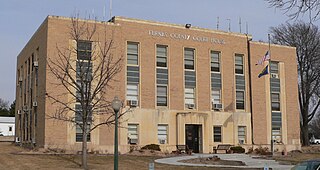
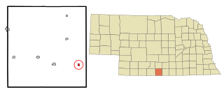
Harlan County is a county in the U.S. state of Nebraska. As of the 2020 United States Census, the population was 3,073. Its county seat is Alma. The county is home to the Harlan County Reservoir.

<span class="mw-page-title-main">Furnas County, Nebraska</span> County in Nebraska, United States

Furnas County is a county in the U.S. state of Nebraska. As of the 2020 United States Census, the population was 4,636. Its county seat is Beaver City. The county was named for Robert Wilkinson Furnas, the second governor of the state of Nebraska.

<span class="mw-page-title-main">Panama, Iowa</span> City in Iowa, United States

Panama is a city in Shelby County, Iowa, United States. The population was 235 at the time of the 2020 census.

<span class="mw-page-title-main">Alma, Kansas</span> City in Wabaunsee County, Kansas

Alma is a city in and the county seat of Wabaunsee County, Kansas, United States. As of the 2020 census, the population of the city was 802.

<span class="mw-page-title-main">Alma, Michigan</span> City in Michigan, United States

Alma is the largest city in Gratiot County in the U.S. state of Michigan. The population was 9,488 at the 2020 census. It was incorporated as the Village of Alma in 1872 and became a city in 1905.

<span class="mw-page-title-main">Greenwood, Nebraska</span> Village in Nebraska, United States

Greenwood is a village in northwest Cass County, Nebraska, United States. The population was 595 at the 2020 census.

<span class="mw-page-title-main">Dakota City, Nebraska</span> City in Dakota County, Nebraska, United States

Dakota City is a city in Dakota County, Nebraska, United States. The population was 1,919 at the 2010 census. It is the county seat of Dakota County. Tyson Foods' largest beef production plant is located in Dakota City.

<span class="mw-page-title-main">Boys Town, Nebraska</span> Village in Douglas County, Nebraska, United States

Boys Town is a village in Douglas County, Nebraska, United States. The population was 410 at the 2020 census. Boys Town is an enclave and a suburb of Omaha.

<span class="mw-page-title-main">Waterloo, Nebraska</span> Village in Douglas County, Nebraska, United States

Waterloo is a village in Douglas County, Nebraska, United States. The population was 935 at the 2020 census.

<span class="mw-page-title-main">Naponee, Nebraska</span> Village in Nebraska, United States

Naponee is a village in Franklin County, Nebraska, United States. The population was 106 at the 2010 census.

<span class="mw-page-title-main">Beaver City, Nebraska</span> City in Nebraska, United States

Beaver City is a city in Furnas County, on the southern border of Nebraska, United States. The population was 609 at the 2010 census. It is the county seat of Furnas County.

<span class="mw-page-title-main">Burwell, Nebraska</span> City in Nebraska, United States

Burwell is a city in Garfield County, Nebraska, United States. The population was 1,210 at the 2010 census. It is the county seat of Garfield County.

<span class="mw-page-title-main">Wood River, Nebraska</span> Village in Hall County, Nebraska, United States

Wood River is a city in southwestern Hall County, Nebraska, United States. The population was 1,172 at the 2020 census. It is part of the Grand Island, Nebraska Metropolitan Statistical Area.

<span class="mw-page-title-main">Orleans, Nebraska</span> Village in Nebraska, United States

Orleans is a village in Harlan County, Nebraska, United States. The population was 386 at the 2010 census.

<span class="mw-page-title-main">Ragan, Nebraska</span> Village in Nebraska, United States

Ragan is a village in Harlan County, Nebraska, United States. The population was 38 at the 2010 census.

<span class="mw-page-title-main">Republican City, Nebraska</span> Village in Nebraska, United States

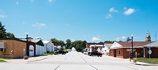
Republican City is a village, despite its name, in Harlan County, Nebraska, United States. The population was 150 at the 2010 census. The town is near the Harlan County Reservoir. At its peak in the 1950s the population was about 4 times larger than it is today.

<span class="mw-page-title-main">Stamford, Nebraska</span> Village in Nebraska, United States

Stamford is a village in Harlan County, Nebraska, United States. The population was 183 at the 2010 census.

<span class="mw-page-title-main">Crofton, Nebraska</span> City in Nebraska, United States

Crofton is a city in Knox County, Nebraska, United States. The population was 726 at the 2010 census.

<span class="mw-page-title-main">Osmond, Nebraska</span> City in Nebraska, United States

Osmond is a city in Pierce County, Nebraska, United States. It is part of the Norfolk, Nebraska Micropolitan Statistical Area. The population was 791 at the 2020 census.

<span class="mw-page-title-main">Miller, South Dakota</span> City in South Dakota, United States

Miller is a city in and county seat of Hand County, South Dakota, United States. The population was 1,349 at the 2020 census.

References

  1. "ArcGIS REST Services Directory". United States Census Bureau. Retrieved September 18, 2022.
  2. 1 2 U.S. Geological Survey Geographic Names Information System: Alma, Nebraska
  3. 1 2 "U.S. Census website". United States Census Bureau . Retrieved January 31, 2008.
  4. "Find a County". National Association of Counties. Archived from the original on May 31, 2011. Retrieved June 7, 2011.
  5. Fitzpatrick, Lilian Linder (1925). "Nebraska Place-Names". University of Nebraska Department of English. Retrieved 2013-04-06.
  6. Burr, George L. (1921). History of Hamilton and Clay Counties, Nebraska, Volume 1. S.J. Clarke Publishing Company. p. 117.
  7. "US Gazetteer files 2010". United States Census Bureau. Archived from the original on January 25, 2012. Retrieved June 24, 2012.
  8. "U.S. Census website". United States Census Bureau . Retrieved June 24, 2012.

Further reading