Minden, Nebraska

Last updated

Minden, Nebraska
Minden, NE.jpg
West side of North Colorado Ave (2017)
Kearney County Nebraska Incorporated and Unincorporated areas Minden Highlighted.svg
Location with Kearney County and Nebraska
Coordinates: 40°29′53″N98°58′01″W / 40.49806°N 98.96694°W / 40.49806; -98.96694
Country United States
State Nebraska
County Kearney
Area
[1]
  Total2.20 sq mi (5.71 km2)
  Land2.20 sq mi (5.71 km2)
  Water0.00 sq mi (0.00 km2)
Elevation
[2]
2,182 ft (665 m)
Population
 (2020)
  Total3,118
  Density1,415.34/sq mi (546.36/km2)
Time zone UTC-6 (Central (CST))
  Summer (DST) UTC-5 (CDT)
ZIP code
68959
Area code 308
FIPS code 31-32340
GNIS ID 2395341 [2]
Website MindenNebraska.org
Christmas lights in Minden's courthouse square (2011) Kearney County, Nebraska courthouse lights 2.jpg
Christmas lights in Minden's courthouse square (2011)

Minden is a city in Kearney County, Nebraska, United States. The city serves as the county seat of Kearney County. [3] The population was 3,118 at the 2020 census. [4] It is home to the Pioneer Village museum complex of 28 buildings.

Contents

History

Minden was established in 1876. [5] The city was named after Minden, in Germany. [6] Minden was originally built up chiefly by Germans. [7] The city has had a post office since 1876. [8]

Geography

According to the United States Census Bureau, the city has a total area of 2.15 square miles (5.57 km2), all land. [9]

Climate

The highest temperature ever measured in Nebraska, at 118 °F (47.8 °C), was recorded in Minden on July 24, 1936, during the 1936 North American heat wave which occurred during the Dust Bowl era. [10]

Climate data for Minden, Nebraska (1991–2020, extremes 1893–present)
MonthJanFebMarAprMayJunJulAugSepOctNovDecYear
Record high °F (°C)78
(26)
81
(27)
92
(33)
99
(37)
105
(41)
110
(43)
118
(48)
114
(46)
107
(42)
97
(36)
82
(28)
80
(27)
118
(48)
Mean maximum °F (°C)60.2
(15.7)
65.9
(18.8)
77.5
(25.3)
85.4
(29.7)
90.8
(32.7)
96.2
(35.7)
99.3
(37.4)
96.4
(35.8)
93.2
(34.0)
87.0
(30.6)
74.3
(23.5)
61.9
(16.6)
100.0
(37.8)
Average high °F (°C)35.2
(1.8)
39.4
(4.1)
51.4
(10.8)
61.3
(16.3)
71.2
(21.8)
81.9
(27.7)
86.7
(30.4)
84.1
(28.9)
77.4
(25.2)
64.4
(18.0)
49.9
(9.9)
37.3
(2.9)
61.7
(16.5)
Daily mean °F (°C)24.8
(−4.0)
28.8
(−1.8)
39.1
(3.9)
49.6
(9.8)
60.4
(15.8)
71.1
(21.7)
75.9
(24.4)
73.4
(23.0)
65.4
(18.6)
51.9
(11.1)
38.3
(3.5)
27.3
(−2.6)
50.5
(10.3)
Average low °F (°C)14.5
(−9.7)
18.1
(−7.7)
26.9
(−2.8)
37.9
(3.3)
49.6
(9.8)
60.3
(15.7)
65.0
(18.3)
62.7
(17.1)
53.5
(11.9)
39.4
(4.1)
26.7
(−2.9)
17.4
(−8.1)
39.3
(4.1)
Mean minimum °F (°C)−6.1
(−21.2)
−1.9
(−18.8)
8.6
(−13.0)
21.6
(−5.8)
33.6
(0.9)
47.2
(8.4)
53.6
(12.0)
50.8
(10.4)
36.5
(2.5)
21.1
(−6.1)
9.3
(−12.6)
−2.0
(−18.9)
−10.8
(−23.8)
Record low °F (°C)−28
(−33)
−33
(−36)
−17
(−27)
0
(−18)
17
(−8)
35
(2)
42
(6)
36
(2)
20
(−7)
1
(−17)
−15
(−26)
−31
(−35)
−33
(−36)
Average precipitation inches (mm)0.48
(12)
0.55
(14)
1.33
(34)
2.38
(60)
4.52
(115)
3.91
(99)
3.61
(92)
3.19
(81)
1.88
(48)
2.11
(54)
0.96
(24)
0.74
(19)
25.66
(652)
Average snowfall inches (cm)5.6
(14)
7.2
(18)
3.3
(8.4)
1.5
(3.8)
0.0
(0.0)
0.0
(0.0)
0.0
(0.0)
0.0
(0.0)
0.0
(0.0)
0.6
(1.5)
2.4
(6.1)
4.2
(11)
24.8
(63)
Average precipitation days (≥ 0.01 in)4.14.55.88.211.29.68.88.36.25.83.83.780.0
Average snowy days (≥ 0.1 in)3.43.41.70.90.00.00.00.00.00.31.23.013.9
Source: NOAA [11] [12]

Demographics

Historical population
CensusPop.Note
1880 98
1890 1,3801,308.2%
1900 1,238−10.3%
1910 1,55925.9%
1920 1,527−2.1%
1930 1,71612.4%
1940 1,8487.7%
1950 2,12014.7%
1960 2,38312.4%
1970 2,66912.0%
1980 2,93910.1%
1990 2,749−6.5%
2000 2,9647.8%
2010 2,923−1.4%
2020 3,1186.7%
U.S. Decennial Census [13]
2012 Estimate [14]

Minden is part of the Kearney, Nebraska Micropolitan Statistical Area.

2010 census

As of the census [15] of 2010, there were 2,923 people, 1,256 households, and 791 families residing in the city. The population density was 1,359.5 inhabitants per square mile (524.9/km2). There were 1,339 housing units at an average density of 622.8 per square mile (240.5/km2). The racial makeup of the city was 96.4% White, 0.4% African American, 0.2% Native American, 0.2% Asian, 1.4% from other races, and 1.4% from two or more races. Hispanic or Latino of any race were 5.2% of the population.

There were 1,256 households, of which 28.7% had children under the age of 18 living with them, 52.2% were married couples living together, 7.5% had a female householder with no husband present, 3.3% had a male householder with no wife present, and 37.0% were non-families. 32.9% of all households were made up of individuals, and 17.8% had someone living alone who was 65 years of age or older. The average household size was 2.26 and the average family size was 2.86.

The median age in the city was 43.1 years. 22.9% of residents were under the age of 18; 6.7% were between the ages of 18 and 24; 22.9% were from 25 to 44; 25.4% were from 45 to 64; and 22.1% were 65 years of age or older. The gender makeup of the city was 46.5% male and 53.5% female.

2000 census

As of the census of 2000, there were 2,964 people, 1,185 households, and 811 families residing in the city. The population density was 1,809.7 inhabitants per square mile (698.7/km2). There were 1,269 housing units at an average density of 774.8 per square mile (299.2/km2). The racial makeup of the city was 98.65% White, 0.17% African American, 0.24% Native American, 0.10% Asian, 0.44% from other races, and 0.40% from two or more races. Hispanic or Latino of any race were 2.33% of the population.

There were 1,185 households, out of which 32.0% had children under the age of 18 living with them, 59.2% were married couples living together, 7.4% had a female householder with no husband present, and 31.5% were non-families. 27.8% of all households were made up of individuals, and 13.9% had someone living alone who was 65 years of age or older. The average household size was 2.38 and the average family size was 2.89.

In the city, the population was spread out, with 24.9% under the age of 18, 6.5% from 18 to 24, 25.5% from 25 to 44, 21.3% from 45 to 64, and 21.8% who were 65 years of age or older. The median age was 40 years. For every 100 females, there were 87.4 males. For every 100 females age 18 and over, there were 82.7 males.

The median income for a household in the city was $40,092, and the median income for a family was $47,356. Males had a median income of $29,267 versus $18,929 for females. The per capita income for the city was $18,847. About 2.3% of families and 5.3% of the population were below the poverty line, including 5.8% of those under age 18 and 6.7% of those age 65 or over.

Attractions

Pioneer Village (2005) Ne minden pioneer village11.jpg
Pioneer Village (2005)

Minden is the home of the Pioneer Village , a museum complex of 28 buildings on 20 acres (81,000 m2) with a total collection of over 50,000 items. [16]

Minden bills itself as "Nebraska's Christmas City", illuminating the courthouse square with a display of over 12,000 bulbs and staging an annual Christmas pageant titled "The Light Of The World". The lighting of the courthouse was begun in 1915, when lights were acquired with the intention of stringing them from the railroad station to the town square for the state G.A.R. convention. Weather precluded this use, and the lights were repurposed for a Christmas display. [17]

Notable people

Related Research Articles

<span class="mw-page-title-main">Adams County, Nebraska</span> County in Nebraska, United States

Adams County is a county located in the U.S. state of Nebraska. As of the 2020 United States Census, the population was 31,205. Its county seat is Hastings. The county was formed in 1867 and organized in 1871. It is named for John Adams, the second President of the United States.

<span class="mw-page-title-main">Kearney County, Nebraska</span> County in Nebraska, United States

Kearney County is a county located in the U.S. state of Nebraska. As of the 2020 United States Census, the population was 6,688. Its county seat is Minden. The county was formed in 1860. It was named for Fort Kearny, which in turn was named for Brigade General Stephen W. Kearny.

<span class="mw-page-title-main">Franklin County, Nebraska</span> County in Nebraska, United States

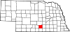
Franklin County is a county in the U.S. state of Nebraska. As of the 2020 census, the population was 2,889. Its county seat is Franklin. The county was formed in 1867 and organized in 1871. It was named for Benjamin Franklin.

<span class="mw-page-title-main">Hartington, Nebraska</span> City in Nebraska, United States

Hartington is a city in Cedar County, Nebraska, United States. The population was 1,514 at the 2020 census.

<span class="mw-page-title-main">Clay Center, Nebraska</span> City in Nebraska, United States

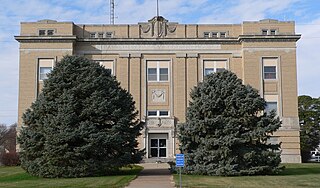
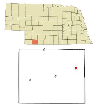
Clay Center is a city in and the county seat of Clay County, Nebraska, United States. It is part of the Hastings, Nebraska Micropolitan Statistical Area. The population was 760 at the 2010 census.

<span class="mw-page-title-main">Chappell, Nebraska</span> City in Nebraska, United States

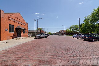
Chappell is a city and county seat of Deuel County, Nebraska, United States. The population was 929 at the 2010 census.

<span class="mw-page-title-main">Hamlet, Nebraska</span> Hamlet, Nebraska

Hamlet is a village in Hayes County, Nebraska, United States. The population was 57 at the 2010 census. A granary is located there, also an elementary school and a community hall, and two churches; otherwise, no other services or businesses.

<span class="mw-page-title-main">Hayes Center, Nebraska</span> Village in Hayes County, Nebraska, United States

Hayes Center is a village in Hayes County, Nebraska, United States, which has served as that county's county seat since 1885. Its population, according to the 2010 U.S. census, was 214.

<span class="mw-page-title-main">Culbertson, Nebraska</span> Village in Hitchcock County, Nebraska, Untie States

Culbertson is a village in Hitchcock County, Nebraska, United States. The population was 534 at the 2020 census.

<span class="mw-page-title-main">Axtell, Nebraska</span> Village in Nebraska, United States

Axtell is a village in western Kearney County, Nebraska, United States. It is part of the Kearney, Nebraska Micropolitan Statistical Area. The population was 732 at the 2020 census.

<span class="mw-page-title-main">Heartwell, Nebraska</span> Village in Nebraska, United States

Heartwell is a village in Kearney County, Nebraska, United States. It is part of the Kearney, Nebraska Micropolitan Statistical Area. The population was 80 at the 2020 census.

<span class="mw-page-title-main">Norman, Nebraska</span> Village in Nebraska, United States

Norman is a village in Kearney County, Nebraska, United States. It is part of the Kearney, Nebraska Micropolitan Statistical Area. The population was 36 at the 2020 census.

<span class="mw-page-title-main">McLean, Nebraska</span> Village in Pierce County, Nebraska, United States

McLean is a village in Pierce County, Nebraska, United States. It is part of the Norfolk, Nebraska Micropolitan Statistical Area. The population was 36 at the 2010 census.

<span class="mw-page-title-main">Osmond, Nebraska</span> City in Nebraska, United States

Osmond is a city in Pierce County, Nebraska, United States. It is part of the Norfolk, Nebraska Micropolitan Statistical Area. The population was 791 at the 2020 census.

<span class="mw-page-title-main">Bassett, Nebraska</span> City in and county seat of Rock County, Nebraska, United States

Bassett is a city in Rock County, Nebraska, United States. The population was 619 at the 2010 census. It is the county seat of Rock County.

<span class="mw-page-title-main">Gretna, Nebraska</span> City in Sarpy County, Nebraska, United States

Gretna is a city in Sarpy County, Nebraska, United States. The population was 5,083 at the 2020 census.

<span class="mw-page-title-main">Rushville, Nebraska</span> City in and county seat of Sheridan Count, Nebraska, United States

Rushville is a city in Sheridan County, Nebraska, United States, in the remote Sandhills Region. Its population was 890 at the 2010 census. It is the county seat of Sheridan County.

<span class="mw-page-title-main">Hazard, Nebraska</span> Village in Sherman County, Nebraska, United States

Hazard is a village in Sherman County, Nebraska, United States. The population was 70 at the 2010 census.

<span class="mw-page-title-main">Hebron, Nebraska</span> City in and county seat of Thayer County, Nebraska, united States

Hebron is a city in and the county seat of Thayer County, Nebraska, United States. The population was 1,441 at the 2020 census.

<span class="mw-page-title-main">Fort Calhoun, Nebraska</span> City in Washington County, Nebraska, United States

Fort Calhoun is a city in Washington County, Nebraska, United States. The population was 908 at the 2010 census. The city includes Fort Atkinson, the first fort built west of the Missouri River.

References

  1. "ArcGIS REST Services Directory". United States Census Bureau. Retrieved September 18, 2022.
  2. 1 2 U.S. Geological Survey Geographic Names Information System: Minden, Nebraska
  3. "Find a County". National Association of Counties. Retrieved June 7, 2011.
  4. "Minden, Nebraska Population". United States Census Bureau . Retrieved November 26, 2023.
  5. Capace, Nancy (1999). Encyclopedia of Nebraska. North American Book Dist LLC. p. 253. ISBN   978-0-403-09834-7.
  6. Gannett, Henry (1905). The Origin of Certain Place Names in the United States. U.S. Government Printing Office. p.  209.
  7. Fitzpatrick, Lillian L. (1960). Nebraska Place-Names. University of Nebraska Press. p. 84. ISBN   0-8032-5060-6. A 1925 edition is available for download at University of Nebraska—Lincoln Digital Commons.
  8. Post Offices in Kearney County, Nebraska
  9. "US Gazetteer files 2010". United States Census Bureau. Archived from the original on January 25, 2012. Retrieved June 24, 2012.
  10. "United States Extreme Record Temperatures & Differences" . Retrieved November 22, 2008.
  11. "NOWData – NOAA Online Weather Data". National Oceanic and Atmospheric Administration. Retrieved January 14, 2022.
  12. "Station: Minden, NE". U.S. Climate Normals 2020: U.S. Monthly Climate Normals (1991–2020). National Oceanic and Atmospheric Administration. Retrieved January 14, 2022.
  13. United States Census Bureau. "Census of Population and Housing" . Retrieved October 19, 2013.
  14. "Annual Estimates of the Resident Population: April 1, 2010 to July 1, 2012". Archived from the original on November 20, 2013. Retrieved October 19, 2013.
  15. "U.S. Census website". United States Census Bureau . Retrieved June 24, 2012.
  16. Exploring Nebraska Highways: Trip Trivia. Exploring America's Highway. 2007. p. 86. ISBN   978-0-9744358-7-9.
  17. "The Christmas City". Minden, Nebraska website. Retrieved 2011-12-10.
  18. "BINDERUP, Charles Gustav, (1873 - 1950)". Biographical Directory of the United States Congress. Retrieved October 6, 2012.
  19. "CURTIS, Carl Thomas, (1905 - 2000)". Biographical Directory of the United States Congress. Retrieved October 6, 2012.
  20. "Nebraska Governor Norbert T. Tiemann". National Governors Association. Retrieved October 6, 2012.
  21. Exploring Nebraska Highways: Trip Trivia. Exploring America's Highway. 2007. p. 86. ISBN   978-0-9744358-7-9.