Schuyler, Nebraska

Last updated

Schuyler, Nebraska
Colfax County Nebraska Incorporated and Unincorporated areas Schuyler Highlighted.svg
Location of Schuyler, Nebraska
Coordinates: 41°26′59″N97°03′43″W / 41.44972°N 97.06194°W / 41.44972; -97.06194
CountryUnited States
State Nebraska
County Colfax
Area
[1]
  Total2.81 sq mi (7.28 km2)
  Land2.73 sq mi (7.06 km2)
  Water0.09 sq mi (0.22 km2)
Elevation
[2]
1,352 ft (412 m)
Population
 (2020)
  Total6,547
  Density2,400.81/sq mi (927.02/km2)
Time zone UTC-6 (Central (CST))
  Summer (DST) UTC-5 (CDT)
ZIP code
68661
Area code 402
FIPS code 31-44035
GNIS feature ID2396556 [2]
Website schuylernebraska.net

Schuyler is a city in Colfax County, Nebraska, United States. The population was 6,211 at the 2010 census. It is the county seat of Colfax County. [3] The city (as well as the county) is named after former Vice President of the United States, Schuyler Colfax. [4]

Contents

Geography

According to the United States Census Bureau, the city has a total area of 2.67 square miles (6.92 km2), of which 2.58 square miles (6.68 km2) is land and 0.09 square miles (0.23 km2) is water. [5]

Demographics

Historical population
CensusPop.Note
1880 1,017
1890 2,160112.4%
1900 2,157−0.1%
1910 2,152−0.2%
1920 2,63622.5%
1930 2,588−1.8%
1940 2,8088.5%
1950 2,8832.7%
1960 3,0967.4%
1970 3,59716.2%
1980 4,15115.4%
1990 4,052−2.4%
2000 5,37132.6%
2010 6,21115.6%
2020 6,5475.4%
U.S. Decennial Census [6]
2012 Estimate [7]

2020 census

The 2020 United States census [8] counted 6,547 people, 1,831 households, and 1,312 families in Schuyler. The population density was 2,398.2 per square mile (927.3/km2). There were 1,947 housing units at an average density of 713.2 per square mile (275.8/km2). The racial makeup was 32.84% (2,150) white, 4.84% (317) black or African-American, 4.44% (291) Native American, 0.52% (34) Asian, 0.02% (1) Pacific Islander, 43.59% (2,854) from other races, and 13.75% (900) from two or more races. Hispanic or Latino of any race was 74.0% (4,645) of the population.

Of the 1,831 households, 41.5% had children under the age of 18; 52.7% were married couples living together; 17.7% had a female householder with no husband present. 15.1% of households consisted of individuals and 7.0% had someone living alone who was 65 years of age or older. The average household size was 3.4 and the average family size was 3.7.

33.4% of the population was under the age of 18, 9.2% from 18 to 24, 20.3% from 25 to 44, 25.4% from 45 to 64, and 7.5% who were 65 years of age or older. The median age was 30.2 years. For every 100 females, the population had 149.6 males. For every 100 females ages 18 and older, there were 126.8 males.

The 2016-2020 5-year American Community Survey [9] estimates show that the median household income was $64,657 (with a margin of error of +/- $4,321) and the median family income $64,162 (+/- $6,233). Males had a median income of $35,584 (+/- $8,433) versus $31,163 (+/- $8,721) for females. The median income for those above 16 years old was $32,283 (+/- $3,452). Approximately, 7.9% of families and 13.8% of the population were below the poverty line, including 10.9% of those under the age of 18 and 8.3% of those ages 65 or over.

2010 census

As of the census [10] of 2010, there were 6,211 people, 1,828 households, and 1,356 families residing in the city. The population density was 2,407.4 inhabitants per square mile (929.5/km2). There were 1,972 housing units at an average density of 764.3 per square mile (295.1/km2). The racial makeup of the city was 56.7% White, 1.3% African American, 1.7% Native American, 0.2% Asian, 37.0% from other races, and 3.0% from two or more races. Hispanic or Latino of any race were 65.4% of the population.

There were 1,828 households, of which 49.9% had children under the age of 18 living with them, 54.0% were married couples living together, 12.0% had a female householder with no husband present, 8.2% had a male householder with no wife present, and 25.8% were non-families. 21.2% of all households were made up of individuals, and 11.1% had someone living alone who was 65 years of age or older. The average household size was 3.37 and the average family size was 3.81.

The median age in the city was 28.5 years. 33.8% of residents were under the age of 18; 10.4% were between the ages of 18 and 24; 27.7% were from 25 to 44; 18.3% were from 45 to 64; and 9.7% were 65 years of age or older. The gender makeup of the city was 51.3% male and 48.7% female.

2000 census

As of the census of 2000, there were 5,371 people, 1,748 households, and 1,214 families residing in the city. The population density was 2,590.1 inhabitants per square mile (1,000.0/km2). There were 1,856 housing units at an average density of 895.0 per square mile (345.6/km2). The racial makeup of the city was 69.30% White, 0.11% African American, 0.26% Native American, 0.28% Asian, 0.24% Pacific Islander, 27.37% from other races, and 2.44% from two or more races. Hispanic or Latino of any race were 45.11% of the population.

There were 1,748 households, out of which 37.7% had children under the age of 18 living with them, 55.0% were married couples living together, 9.0% had a female householder with no husband present, and 30.5% were non-families. 25.6% of all households were made up of individuals, and 16.6% had someone living alone who was 65 years of age or older. The average household size was 3.03 and the average family size was 3.52.

In the city, the population was spread out, with 29.7% under the age of 18, 10.7% from 18 to 24, 28.7% from 25 to 44, 16.5% from 45 to 64, and 14.4% who were 65 years of age or older. The median age was 31 years. For every 100 females, there were 108.9 males. For every 100 females age 18 and over, there were 108.8 males.

As of 2000 the median income for a household in the city was $37,170, and the median income for a family was $41,747. Males had a median income of $24,955 versus $20,615 for females. The per capita income for the city was $14,376. About 6.3% of families and 11.2% of the population were below the poverty line, including 14.8% of those under age 18 and 4.2% of those age 65 or over.

Economy

Schuyler's single largest employer is the Cargill beef processing plant, with approximately 2,000 employees. The plant opened in 1968 as a Spencer Packing Co. facility. [11] Other major employers include Schuyler Community Schools, with 245 employees; Alegent Health Memorial Hospital, with 82 full-time and 31 part-time employees; and QC Supply, a manufacturer and distributor of farm and ranch supplies with 75 full-time employees. [12]

History

In 1866, the Union Pacific Railroad reached present-day Schuyler, at the time known as Shell Creek Station. Three years later, the Nebraska State Legislature divided large Platte County into three smaller counties, including Colfax County. In 1870, Shell Creek Station was renamed Schuyler. [13]

In 1870, the Union Pacific chose the town as the point at which Texas cattle being driven north would be loaded onto trains. With this, Schuyler became Nebraska's first "cow town". However, the resulting boom, which saw a six-fold increase in the town's population (from 100 to 600) and around 50,000 head of cattle pass through, was only temporary: the next year, the terminus of the cattle trail had moved west to Kearney. [14]

The city's early residents were Czech, Irish, and German settlers. Settlement was enabled by Schuyler's geographic position, which caused the community to be associated with a number of historic overland transportation routes, including:

Beginning in the late 1980s, reductions in wages at the Cargill beef processing plant led to a change in Schuyler's demographic makeup. By 2017, an estimated 60% of the population was Latino, and immigrants from other parts of the world, including Somalia and Thailand, had also moved to the city. [15]

In December 2020, the Schuyler City Council voted to reject the formation of a board of health, which would have potentially resulted in a mask mandate. [16] In January 2021, the city council voted to establish a board of health and appointed members, after two previous attempts failed. [17] The council passed a revised ordinance which gave the board power to only suggest actions to the city council.

In March 2021, law enforcement sent a letter to Schuyler Community Schools complaining about an incident on February 24, 2021 involving a student. [18] Law enforcement also said the relationship between the two entities was strained. [18]

Christ the King Priory Christ the King Priory, Schuyler, NE.jpg
Christ the King Priory
Saint Benedict Center Saint Benedict Center, Schuyler, NE, USA.jpg
Saint Benedict Center

Attractions

In 1935, monks from the Congregation of Missionary Benedictines of Saint Ottilien established a community in Schuyler as a means of supporting the congregation's missions in Africa and Asia. At present, Christ the King Priory is home to 11 monks. The monks' apostolate has expanded to providing retreats at the recently constructed Saint Benedict Center, four miles north of Schuyler. [19]

The Oak Ballroom's ceiling beams Schuyler Oak Ballroom interior 4.JPG
The Oak Ballroom's ceiling beams

The Oak Ballroom, completed by the Works Progress Administration in 1937 and now listed on the National Register of Historic Places, was built using dozens of native oak trees hauled to the building site from the nearby Platte River using horses and wagons. [20]

Transportation

Intercity bus service to the city is provided by Express Arrow. [21]

Notable people

Related Research Articles

<span class="mw-page-title-main">Colfax County, New Mexico</span> County in New Mexico, United States

Colfax County is a county in the U.S. state of New Mexico. As of the 2020 census, the population was 12,387. Its county seat is Raton. It is south from the Colorado state line. This county was named for Schuyler Colfax (1823–1885), seventeenth Vice President of the United States under U.S. President Ulysses S. Grant.

<span class="mw-page-title-main">Colfax County, Nebraska</span> County in Nebraska, United States

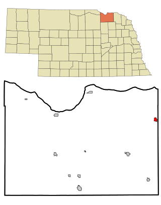
Colfax County is a county in the U.S. state of Nebraska. As of the 2020 United States Census, the population was 10,582. Its county seat is Schuyler. The county and its seat are named after US Vice President (1869-1873) Schuyler Colfax.

<span class="mw-page-title-main">Colfax, Indiana</span> Town in Indiana, United States

Colfax is a town in Perry Township, Clinton County, Indiana, United States. The population was 691 at the 2010 census. The town was originally known as Midway since it was a half-way point on the IC&L Railroad between Chicago & Louisville. Railways intersected North/South & East/West making Colfax a popular transfer destination. The town was renamed to honor Vice President Schuyler Colfax in 1857.

<span class="mw-page-title-main">Colfax, Iowa</span> City in Iowa, US

Colfax is a city in Jasper County, Iowa, United States. Colfax is located approximately 24 miles east of Des Moines. The town was founded in 1866, and was named after Schuyler Colfax, vice president under Ulysses S. Grant. The population was 2,255 at the time of the 2020 census. Newton is the county seat; both were named after Revolutionary War soldiers.

Colfax Township is a township in Kandiyohi County, Minnesota, United States. The population was 557 at the 2000 census.

<span class="mw-page-title-main">Ainsworth, Nebraska</span> City in and county seat of Brown County, Nebraska, United States

Ainsworth is a city and county seat of Brown County, Nebraska, United States. The population was 1,728 at the 2010 census.

<span class="mw-page-title-main">Clarkson, Nebraska</span> City in Nebraska, United States

Clarkson is a city in Colfax County, Nebraska, United States. The population was 658 at the 2010 census.

<span class="mw-page-title-main">Howells, Nebraska</span> Village in Nebraska, United States

Howells is a village in Colfax County, Nebraska, United States. The population was 561 at the 2010 census.

<span class="mw-page-title-main">Leigh, Nebraska</span> Village in Nebraska, United States

Leigh is a village in Colfax County, Nebraska, United States. The population was 405 at the 2010 census.

<span class="mw-page-title-main">Richland, Nebraska</span> Village in Nebraska, United States

Richland is a village in Colfax County, Nebraska, United States. The population was 73 at the 2010 census.

<span class="mw-page-title-main">Rogers, Nebraska</span> Village in Nebraska, United States

Rogers is a village in Colfax County, Nebraska, United States. The population was 95 at the 2010 census.

<span class="mw-page-title-main">Dakota City, Nebraska</span> City in Dakota County, Nebraska, United States

Dakota City is a city in Dakota County, Nebraska, United States. The population was 1,919 at the 2010 census. It is the county seat of Dakota County. Tyson Foods' largest beef production plant is located in Dakota City.

<span class="mw-page-title-main">Beaver City, Nebraska</span> City in Nebraska, United States

Beaver City is a city in Furnas County, on the southern border of Nebraska, United States. The population was 609 at the 2010 census. It is the county seat of Furnas County.

<span class="mw-page-title-main">Ogallala, Nebraska</span> City in Nebraska, United States

Ogallala is a city in and the county seat of Keith County, Nebraska, United States. The population was 4,878 at the 2020 census, up from 4,737 at the 2010 census. In the days of the Nebraska Territory, the city was a stop on the Pony Express and later along the transcontinental railroad. The Ogallala Formation that carries the Ogallala Aquifer was named after the city.

<span class="mw-page-title-main">Crofton, Nebraska</span> City in Nebraska, United States

Crofton is a city in Knox County, Nebraska, United States. The population was 726 at the 2010 census.

<span class="mw-page-title-main">Pierce, Nebraska</span> City in Nebraska, United States

Pierce is a city in and county seat of Pierce County, Nebraska, United States. The population was 1,767 at the 2010 census.

<span class="mw-page-title-main">Wilber, Nebraska</span> City in Saline County, Nebraska, United States

Wilber is a city in and the county seat of Saline County, Nebraska, United States. The population was 1,855 at the 2010 census. It is the county seat of Saline County. Wilber is the official "Czech Capital of the USA" and hosts an annual Czech festival in August. Wilber's school is the Wilber-Clatonia High School.

<span class="mw-page-title-main">Bellevue, Nebraska</span> City in Sarpy County, Nebraska, United States

Bellevue is a suburban city in Sarpy County, Nebraska, United States. It is part of the Omaha–Council Bluffs metropolitan area, and had a population of 64,176 as of the 2020 census, making it the 3rd most populous city in Nebraska, behind Omaha and Lincoln, and the second largest city in the U.S. named "Bellevue," behind Bellevue, Washington.

<span class="mw-page-title-main">York, Nebraska</span> City in and county seat of York County, Nebraska, United States

York is a city in and the county seat of York County, Nebraska, United States. At the 2010 census, the city population was 7,766. It is the home of York University and the Nebraska Correctional Center for Women.

<span class="mw-page-title-main">Colfax, Wisconsin</span> Village in Wisconsin, United States

Colfax is a village in Dunn County, Wisconsin, United States. The population was 1,158 at the 2010 census. The village is surrounded by the Town of Colfax.

References

  1. "ArcGIS REST Services Directory". United States Census Bureau. Retrieved September 18, 2022.
  2. 1 2 U.S. Geological Survey Geographic Names Information System: Schuyler, Nebraska
  3. "Find a County". National Association of Counties. Retrieved June 7, 2011.
  4. Bain, David Haward (2004). The Old Iron Road: An Epic of Rails, Roads, and the Urge to Go West. New York City, New York: Penguin Books. pp. 65–6. ISBN   0-14-303526-6.
  5. "US Gazetteer files 2010". United States Census Bureau. Archived from the original on January 12, 2012. Retrieved June 24, 2012.
  6. United States Census Bureau. "Census of Population and Housing" . Retrieved October 16, 2013.
  7. "Annual Estimates of the Resident Population: April 1, 2010 to July 1, 2012". Archived from the original on October 19, 2013. Retrieved October 16, 2013.
  8. "Explore Census Data". data.census.gov. Retrieved December 18, 2023.
  9. "Explore Census Data". data.census.gov. Retrieved December 18, 2023.
  10. "U.S. Census website". United States Census Bureau . Retrieved June 24, 2012.
  11. "Cargill's Schuyler plant celebrates 50 years". Schuyler Sun. September 25, 2018. Retrieved April 20, 2022.
  12. "Community Facts: Schuyler, Nebraska". Nebraska Public Power District. October 2009. Retrieved 2010-03-05.
  13. "Schuyler, Nebraska" . Retrieved July 9, 2012.
  14. Olson, James C. (1966). History of Nebraska (Second ed.). Lincoln, Nebraska: University of Nebraska Press. pp.  186–87. ISBN   0-8032-5790-2.
  15. Khrais, Reema; Palacios, Daisy (September 8, 2017). "How Latinos are transforming the economy of a small rural town". Marketplace. Retrieved December 12, 2017.
  16. Sun, CAROLYN KOMATSOULIS Schuyler. "Schuyler City Council rejects board of health". Columbus Telegram. Retrieved October 4, 2021.
  17. Sun, CAROLYN KOMATSOULIS Schuyler. "Schuyler forms its Board of Health". Columbus Telegram. Retrieved October 4, 2021.
  18. 1 2 Sun, CAROLYN KOMATSOULIS Schuyler. "Superintendent talks Schuyler Community Schools' actions during weapons incident". Columbus Telegram. Retrieved October 4, 2021.
  19. The Schuyler Sun, Volume 113 No. 43
  20. Nebraska Public Television – Statewide "NET Educational Services". Archived from the original on July 19, 2011. Retrieved April 27, 2010.
  21. "Locations" . Retrieved July 20, 2023.
  22. 'Wisconsin Blue Book 1901,' Biographical Sketch of John C. Karel, pg. 757

Further reading