Hartington, Nebraska | |
---|---|
Coordinates: 42°37′13″N97°16′02″W / 42.62028°N 97.26722°W | |
Country | United States |
State | Nebraska |
County | Cedar |
Area | |
• Total | 1.02 sq mi (2.63 km2) |
• Land | 1.02 sq mi (2.63 km2) |
• Water | 0.00 sq mi (0.00 km2) |
Elevation | 1,414 ft (431 m) |
Population | |
• Total | 1,514 |
• Estimate (2021) [3] | 1,506 |
• Density | 1,493.11/sq mi (576.47/km2) |
Time zone | UTC-6 (Central (CST)) |
• Summer (DST) | UTC-5 (CDT) |
ZIP code | 68739 |
Area code | 402 |
FIPS code | 31-21275 [4] |
GNIS feature ID | 2394310 [2] |
Website | www |
Hartington is a city in Cedar County, Nebraska, United States. The population was 1,514 at the 2020 census. [3]
Hartington was platted in 1883, as a water stop on the railroad. [5] It was named for Lord Hartington, who had then recently paid a visit to the U.S. [6] [7]
Hartington includes a number of historic buildings. These include three brick structures on the National Register of Historic Places: the Prairie School Hartington City Hall and Auditorium (1921-1923), the Romanesque Revival Cedar County Courthouse (1890-1891), and the Colonial Revival Hartington Hotel (1917). [8]
According to the United States Census Bureau, the city has a total area of 0.94 square miles (2.43 km2), all land. [9]
Hartington is served by Nebraska State Highways 57 and 84.
On July 17, 1936, Hartington experienced the highest recorded temperature in Nebraska state history at 118 °F (47.8 °C); it shares this record with Minden and Geneva. [10]
Climate data for Hartington, Nebraska (1991–2020, extremes 1893–present) | |||||||||||||
---|---|---|---|---|---|---|---|---|---|---|---|---|---|
Month | Jan | Feb | Mar | Apr | May | Jun | Jul | Aug | Sep | Oct | Nov | Dec | Year |
Record high °F (°C) | 74 (23) | 76 (24) | 92 (33) | 102 (39) | 108 (42) | 109 (43) | 118 (48) | 111 (44) | 105 (41) | 97 (36) | 82 (28) | 72 (22) | 118 (48) |
Mean maximum °F (°C) | 55.4 (13.0) | 59.8 (15.4) | 73.4 (23.0) | 83.3 (28.5) | 88.9 (31.6) | 93.9 (34.4) | 94.9 (34.9) | 93.8 (34.3) | 90.7 (32.6) | 85.7 (29.8) | 70.6 (21.4) | 55.7 (13.2) | 96.9 (36.1) |
Average high °F (°C) | 30.3 (−0.9) | 34.8 (1.6) | 47.1 (8.4) | 59.2 (15.1) | 70.4 (21.3) | 80.3 (26.8) | 84.8 (29.3) | 82.4 (28.0) | 76.0 (24.4) | 62.5 (16.9) | 46.8 (8.2) | 33.6 (0.9) | 59.0 (15.0) |
Daily mean °F (°C) | 20.2 (−6.6) | 24.1 (−4.4) | 35.4 (1.9) | 47.1 (8.4) | 59.1 (15.1) | 69.6 (20.9) | 74.0 (23.3) | 71.4 (21.9) | 63.5 (17.5) | 50.1 (10.1) | 35.7 (2.1) | 24.0 (−4.4) | 47.9 (8.8) |
Average low °F (°C) | 10.1 (−12.2) | 13.3 (−10.4) | 23.7 (−4.6) | 35.0 (1.7) | 47.8 (8.8) | 59.0 (15.0) | 63.2 (17.3) | 60.4 (15.8) | 51.0 (10.6) | 37.7 (3.2) | 24.6 (−4.1) | 14.3 (−9.8) | 36.7 (2.6) |
Mean minimum °F (°C) | −10.4 (−23.6) | −6.2 (−21.2) | 4.0 (−15.6) | 20.8 (−6.2) | 33.7 (0.9) | 46.7 (8.2) | 51.2 (10.7) | 49.3 (9.6) | 34.7 (1.5) | 22.1 (−5.5) | 7.0 (−13.9) | −6.6 (−21.4) | −14.8 (−26.0) |
Record low °F (°C) | −38 (−39) | −33 (−36) | −17 (−27) | 1 (−17) | 19 (−7) | 35 (2) | 38 (3) | 35 (2) | 20 (−7) | 5 (−15) | −17 (−27) | −33 (−36) | −38 (−39) |
Average precipitation inches (mm) | 0.57 (14) | 0.84 (21) | 1.50 (38) | 3.21 (82) | 4.37 (111) | 4.64 (118) | 3.46 (88) | 3.34 (85) | 3.01 (76) | 2.56 (65) | 1.30 (33) | 0.79 (20) | 29.59 (752) |
Average snowfall inches (cm) | 8.1 (21) | 6.7 (17) | 6.2 (16) | 4.0 (10) | 0.0 (0.0) | 0.0 (0.0) | 0.0 (0.0) | 0.0 (0.0) | 0.0 (0.0) | 0.9 (2.3) | 4.6 (12) | 4.8 (12) | 35.3 (90) |
Average precipitation days (≥ 0.01 in) | 3.9 | 4.3 | 5.1 | 8.6 | 10.0 | 8.9 | 7.2 | 7.0 | 6.1 | 5.6 | 4.0 | 4.0 | 74.7 |
Average snowy days (≥ 0.1 in) | 4.6 | 3.7 | 3.0 | 1.2 | 0.0 | 0.0 | 0.0 | 0.0 | 0.0 | 0.4 | 2.2 | 3.9 | 19.0 |
Source: NOAA [11] [12] |
Census | Pop. | Note | %± |
---|---|---|---|
1900 | 971 | — | |
1910 | 1,413 | 45.5% | |
1920 | 1,467 | 3.8% | |
1930 | 1,568 | 6.9% | |
1940 | 1,688 | 7.7% | |
1950 | 1,660 | −1.7% | |
1960 | 1,648 | −0.7% | |
1970 | 1,581 | −4.1% | |
1980 | 1,730 | 9.4% | |
1990 | 1,583 | −8.5% | |
2000 | 1,640 | 3.6% | |
2010 | 1,554 | −5.2% | |
2020 | 1,514 | −2.6% | |
U.S. Decennial Census [3] |
At the 2010 census there were 1,554 people, 641 households, and 402 families living in the city. The population density was 1,653.2 inhabitants per square mile (638.3/km2). There were 715 housing units at an average density of 760.6 per square mile (293.7/km2). The racial make-up of the city was 99.2% White, 0.1% African American, 0.2% Native American, 0.1% Asian, 0.1% from other races, and 0.3% from two or more races. Hispanic or Latino of any race were 0.5%. [13]
Of the 641 households 28.4% had children under the age of 18 living with them, 56.5% were married couples living together, 4.4% had a female householder with no husband present, 1.9% had a male householder with no wife present, and 37.3% were non-families. 34.8% of households were one person and 21.3% were one person aged 65 or older. The average household size was 2.34 and the average family size was 3.08.
The median age was 42.6 years. 26.1% of residents were under the age of 18; 6.1% were between the ages of 18 and 24; 19.7% were from 25 to 44; 21.9% were from 45 to 64; and 26.2% were 65 or older. The gender makeup of the city was 49.8% male and 50.2% female.
At the 2000 census there were 1,640 people, 670 households, and 416 families living in the city. The population density was 1,821.5 inhabitants per square mile (703.3/km2). There were 738 housing units at an average density of 819.7 per square mile (316.5/km2). The racial makeup of the city was 99.15% White, 0.12% Native American, 0.06% from other races, and 0.67% from two or more races. Hispanic or Latino of any race were 0.24%. [4]
Of the 670 households 30.1% had children under the age of 18 living with them, 55.4% were married couples living together, 4.3% had a female householder with no husband present, and 37.9% were non-families. 34.5% of households were one person and 22.1% were one person aged 65 or older. The average household size was 2.36 and the average family size was 3.12.
The age distribution was 27.3% under the age of 18, 6.1% from 18 to 24, 22.4% from 25 to 44, 18.3% from 45 to 64, and 25.9% 65 or older. The median age was 40 years. For every 100 females, there were 96.4 males. For every 100 females age 18 and over, there were 88.0 males.
The median household income was $33,365, and the median family income was $43,897. Males had a median income of $30,848 versus $18,452 for females. The per capita income for the city was $16,133. About 1.7% of families and 6.2% of the population were below the poverty line, including 2.0% of those under age 18 and 11.1% of those age 65 or over.
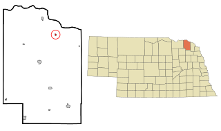
Wheeler County is a county in the U.S. state of Nebraska. As of the 2020 United States Census, the population was 774. Its county seat is Bartlett. The county was formed in 1877 and organized in 1881. The county was named for Major Daniel H. Wheeler, longtime secretary of the Nebraska State Board of Agriculture.
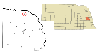
Cedar County is a county in the U.S. state of Nebraska. As of the 2020 United States Census, the population was 8,380. The county seat is Hartington. The county was formed in 1857, and was named for the Cedar tree groves in the area.
Toulon is a city in Stark County, Illinois, United States. The population was 1,292 at the 2010 census. It is the county seat of Stark County. Toulon is part of the Peoria, Illinois Metropolitan Statistical Area, and is the northwestern terminus of the Rock Island Trail State Park.
Cedar Rapids is a village in Boone County, Nebraska, United States. The population was 382 at the 2010 census.
Cedar Creek is a village in Cass County, Nebraska, United States. The population was 465 at the 2020 census.
Nehawka is a village in southeast Cass County, Nebraska, United States. The population was 173 at the 2020 census.
Belden is a village in Cedar County, Nebraska, United States. The population was 112 at the 2020 census.
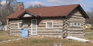
Obert is a village in Cedar County, Nebraska, United States. The population was 23 at the 2020 census.
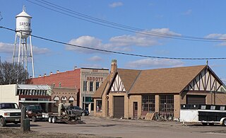
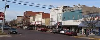
Randolph is a city in Cedar County, Nebraska, United States. The population was 881 at the 2020 census. It refers to itself as "The Honey Capital of the Nation" due to the per-capita number of bee keeping families.
Wynot is a village in Cedar County, Nebraska, United States. The population was 217 at the 2020 census.
Fairfield is a city in Clay County, Nebraska, United States. The population was 387 at the 2010 census. It is part of the Hastings, Nebraska Micropolitan Statistical Area.
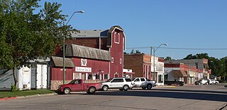
Sargent is a city in Custer County, Nebraska, United States. The population was 525 at the 2010 census.
Geneva is a city in, and the county seat of, Fillmore County, Nebraska, United States. The population was 2,217 at the 2010 census.
Franklin is a city in Franklin County, Nebraska, United States. The population was 1,000 at the 2010 census. It is the county seat of Franklin County.
Pawnee City is a city in and the county seat of Pawnee County, Nebraska, United States. The population was 878 at the 2010 census.
Crete is a city in and the most populous municipality of Saline County, Nebraska, United States. The population was 7,099 at the 2020 census. The city is home to Doane University.
Wilber is a city in and the county seat of Saline County, Nebraska, United States. The population was 1,855 at the 2010 census. It is the county seat of Saline County. Wilber is the official "Czech Capital of the USA" and hosts an annual Czech festival in August. Wilber's school is the Wilber-Clatonia High School.
Cedar Bluffs is a village in Saunders County, Nebraska, United States. The population was 615 at the 2020 census. Cedar Bluffs was a point on the Mormon, Oregon, and California Trails.
Hebron is a city in and the county seat of Thayer County, Nebraska, United States. The population was 1,441 at the 2020 census.
Cedar Catholic High School is a private, Roman Catholic high school in Hartington, Nebraska, United States. It is located in the Roman Catholic Archdiocese of Omaha.
{{cite web}}
: CS1 maint: unfit URL (link)