List of submarine topographical features

Last updated
Depiction of the abyssal zone in relation to other major oceanic zones. Oceanic divisions.svg
Depiction of the abyssal zone in relation to other major oceanic zones.

This is a list of submarine topographical features, oceanic landforms and topographic elements.

Contents

Abyssal plain

An abyssal plain is an underwater plain on the deep ocean floor, usually found at depths between 3,000 meters (9,800 ft) and 6,000 meters (20,000 ft). Lying generally between the foot of a continental rise and a mid-ocean ridge, abyssal plains are among the flattest, smoothest and least explored regions on Earth. [1] Abyssal plains are key geologic elements of oceanic basins (the other elements being an elevated mid-ocean ridge and flanking abyssal hills). In addition to these elements, active oceanic basins (those that are associated with a moving plate tectonic boundary) also typically include an oceanic trench and a subduction zone. Abyssal plains cover more than 33% of the ocean floor (about 23% of Earth's surface), [2] but they are poorly preserved in the sedimentary record because they tend to be consumed by the subduction process. [1] [3] [4]

The abyssal plain is formed when the lower oceanic crust is melted and forced upwards by the asthenosphere layer of the upper mantle. As this basaltic material reaches the surface at mid-ocean ridges, it forms new oceanic crust. Abyssal plains result from the blanketing of an originally uneven surface of oceanic crust by fine-grained sediments, mainly clay and silt. Much of this sediment is deposited from turbidity currents that have been channeled from the continental margins along submarine canyons down into deeper water. The remainder of the sediment is composed chiefly of pelagic sediments.

Use of a continuously recording fathometer enabled Tolstoy & Ewing in the summer of 1947 to identify and describe the first abyssal plain. [1] [5] This plain, located to the south of Newfoundland, is now known as the Sohm Abyssal Plain. [5] Following this discovery many other examples were found in all the oceans. [6] [7] [8] [9] [10]

List of abyssal plains and oceanic basins

Following is a list of named abyssal plains and oceanic basins: [1] [11] [12]

NameAlternate nameOcean Coordinates [11]
Adriatic Abyssal Plain (Adriatic Basin)Mediterranean 43°0′N15°0′E / 43.000°N 15.000°E / 43.000; 15.000
Agulhas Bank [13] (Agulhas Basin) South Atlantic Ocean 35°30′S21°00′E / 35.500°S 21.000°E / -35.500; 21.000
Alaska Plain (Alaskan Abyssal Plain, Alaskan Plain) North Pacific Ocean 55°0′N143°0′W / 55.000°N 143.000°W / 55.000; -143.000
Alborán Plain (Alboran Abyssal Plain) Alboran Sea (Mediterranean Sea) 35°55′N3°50′W / 35.917°N 3.833°W / 35.917; -3.833
Aleutian Basin (Aleutskaya Kotlovina, Bering Abyssal Plain, Bering Basin, Bering Sea Basin)North Pacific Ocean 57°0′N177°0′E / 57.000°N 177.000°E / 57.000; 177.000
Amerasia Basin (Central Polar Basin; consists of the Canada Basin and the Makarov Basin)
Amundsen Basin (Amundsen Basin) Arctic Ocean 89°0′N80°0′E / 89.000°N 80.000°E / 89.000; 80.000
Amundsen Plain (Amundsen Abyssal Plain) Southern Ocean 65°0′S125°0′W / 65.000°S 125.000°W / -65.000; -125.000
Angola Plain [14] [15] [16]

[17]

(Angola Abyssal Plain, Angola Basin)South Atlantic Ocean 15°0′S2°0′E / 15.000°S 2.000°E / -15.000; 2.000
Argentine Abyssal Plain (Argentine Plain, Argentine Basin)South Atlantic Ocean 47°30′S50°0′W / 47.500°S 50.000°W / -47.500; -50.000
Atlantic-Indian Basin [18] [19] Indian Ocean 60°0′S15°0′E / 60.000°S 15.000°E / -60.000; 15.000
Balearic Abyssal Plain Mediterranean Sea 40°00′N01°30′E / 40.000°N 1.500°E / 40.000; 1.500
Baffin Basin (Baffin Bay Basin) North Atlantic Ocean 73°15′N67°0′W / 73.250°N 67.000°W / 73.250; -67.000
Barracuda Plain (Barracuda Abyssal Plain)North Atlantic Ocean 17°0′N56°30′W / 17.000°N 56.500°W / 17.000; -56.500
Bauer Basin
Bellingshausen Plain (Bellingshausen Abyssal Plain)Southern Ocean 64°0′S90°0′W / 64.000°S 90.000°W / -64.000; -90.000
Biscay Plain [20] (Biscay Abyssal Plain)North Atlantic Ocean 45°0′N7°15′W / 45.000°N 7.250°W / 45.000; -7.250
Blake Basin (Blake Abyssal Plain)North Atlantic Ocean 29°30′N76°4′W / 29.500°N 76.067°W / 29.500; -76.067
Boreas Plain (Boreas Abyssal Plain) Arctic Ocean 77°0′N1°0′E / 77.000°N 1.000°E / 77.000; 1.000
Burdwood Abyssal Plain South Atlantic Ocean
Canada Plain [21] (Canada Abyssal Plain, Canada Basin, Canada Deep, Canadian Plain, Kanadskaya Abissal'naya Ravnina Kanadskaya). One of two sub-basins of the Amerasia Basin.Arctic Ocean 80°0′N140°0′W / 80.000°N 140.000°W / 80.000; -140.000
Canary Basin
Cape Plain [14] (Cape Abyssal Plain, Cape Basin)South Atlantic Ocean 34°45′S6°0′E / 34.750°S 6.000°E / -34.750; 6.000
Cape Verde Plain [22] (Cape Verde Abyssal Plain)North Atlantic Ocean 23°0′N26°0′W / 23.000°N 26.000°W / 23.000; -26.000
Cascadia Plain (Cascadia Abyssal Plain, Cascadia Basin, Bassin Cascadia, Great Trough)North Pacific Ocean 47°0′N127°30′W / 47.000°N 127.500°W / 47.000; -127.500
Ceará Plain (Brazil Basin, Ceara Abyssal Plain)North Atlantic Ocean 0°0′N36°30′W / 0.000°N 36.500°W / 0.000; -36.500
Central Pacific Basin
Ceylon Plain (Ceylon Abyssal Plain) Indian Ocean 4°0′S82°0′E / 4.000°S 82.000°E / -4.000; 82.000
Chile Basin
Chukchi Plain [21] (Chukchi Abyssal Plain)Arctic Ocean 77°0′N172°0′W / 77.000°N 172.000°W / 77.000; -172.000
Cocos Abyssal Plain (Cocos Basin)Indian Ocean
Colombian Plain (Colombia Abyssal Plain, Colombian Abyssal Plain)Caribbean (Atlantic Ocean) 13°0′N76°0′W / 13.000°N 76.000°W / 13.000; -76.000
Comoro Plain (Comores Abyssal Plain) Mozambique Channel (Indian Ocean) 13°45′S44°30′E / 13.750°S 44.500°E / -13.750; 44.500
Cuvier Plain (Cuvier Abyssal Plain)Indian Ocean 22°0′S111°0′E / 22.000°S 111.000°E / -22.000; 111.000
Demerara Plain (Demerara Abyssal Plain)North Atlantic Ocean 10°0′N48°0′W / 10.000°N 48.000°W / 10.000; -48.000
Dibble Basin Southern Ocean 65°20′S133°0′E / 65.333°S 133.000°E / -65.333; 133.000
Dumshaf Plain (Dumshaf Abyssal Plain)Arctic Ocean 68°0′N5°0′E / 68.000°N 5.000°E / 68.000; 5.000
Enderby Plain [23] [24] (Enderby Abyssal Plain, East Abyssal Plain)Southern Ocean 60°0′S40°0′E / 60.000°S 40.000°E / -60.000; 40.000
Eratosthenes Abyssal Plain [25] [26] (Eratosthenes Seamount)Mediterranean Sea 33°40′N32°40′E / 33.667°N 32.667°E / 33.667; 32.667
Eurasian Basin (Norway Abyssal Plain, Norwegian Basin; consists of the Amundsen Basin and the Nansen Basin) Arctic Ocean 80°N90°E / 80°N 90°E / 80; 90
Euxine Abyssal Plain [27] [28] [29] Black Sea
Fernando de Noronha Plain (Fernando de Noronha Abyssal Plain, Planicie Abissal de Fernando de Noronha)South Atlantic Ocean 3°0′S31°0′W / 3.000°S 31.000°W / -3.000; -31.000
Ferradura Plain (Ferradura Abyssal Plain, Planicie Abissal da Ferradura)North Atlantic Ocean 36°0′N10°45′W / 36.000°N 10.750°W / 36.000; -10.750
Fletcher Plain (Abissal’naya Ravnina Fletchera)Arctic Ocean 86°0′N179°59′W / 86.000°N 179.983°W / 86.000; -179.983
Florida Plain (Florida Abyssal Plain) Gulf of Mexico (Atlantic Ocean) 25°30′N86°0′W / 25.500°N 86.000°W / 25.500; -86.000
Fram Basin [21] (Barents Abyssal Plain, Barents Plain) One of two sub-basins of the Eurasian Basin.Arctic Ocean 83°0′N35°0′E / 83.000°N 35.000°E / 83.000; 35.000
Gambia Plain (Gambia Abyssal Plain, Gambia Basin)North Atlantic Ocean 12°0′N28°0′W / 12.000°N 28.000°W / 12.000; -28.000
Gascoyne Plain (Exmouth Abyssal Plain, Gascogne Plain, Gascoyne Abyssal Plain)Indian Ocean 16°0′S110°0′E / 16.000°S 110.000°E / -16.000; 110.000
Greenland Plain (Greenland Abyssal Plain, Iceland Basin, Plaine du Groenland)Arctic Ocean 75°0′N3°0′W / 75.000°N 3.000°W / 75.000; -3.000
Grenada Abyssal Plain Caribbean Sea (Atlantic Ocean)
Guiana Basin
Guinea Plain [14] (Guinea Abyssal Plain)North Atlantic Ocean 1°0′N3°0′W / 1.000°N 3.000°W / 1.000; -3.000
Hatteras Plain (Hatteras Abyssal Plain)North Atlantic Ocean 31°0′N71°0′W / 31.000°N 71.000°W / 31.000; -71.000
Herodotus Basin (Herodotus Abyssal Plain, Herodotus Plain) Levantine Sea (Mediterranean Sea) 33°0′N28°0′E / 33.000°N 28.000°E / 33.000; 28.000
Hellenic Trench (Metapan Deep System) Ionian Sea 36°23′N22°38′E / 36.383°N 22.633°E / 36.383; 22.633
Hispaniola Plain (Hispaniola Abyssal Plain)North Atlantic Ocean 20°18′N71°35′W / 20.300°N 71.583°W / 20.300; -71.583
Horseshoe Plain (Horseshoe Abyssal Plain)North Atlantic Ocean 35°40′N12°20′W / 35.667°N 12.333°W / 35.667; -12.333
Iberian Plain [30] [31] (Iberia Abyssal Plain, Iberian Abyssal Plain)North Atlantic Ocean 43°45′N13°30′W / 43.750°N 13.500°W / 43.750; -13.500
Jamaican Abyssal Plain Caribbean Sea (Atlantic Ocean)
Japan Plain (Japan Abyssal Plain) Sea of Japan (Pacific Ocean) 41°30′N135°0′E / 41.500°N 135.000°E / 41.500; 135.000
JOIDES Basin Southern Ocean 74°30′S174°0′E / 74.500°S 174.000°E / -74.500; 174.000 [32]
Labrador Basin (Labrador Sea Basin)North Atlantic Ocean 53°0′N48°0′W / 53.000°N 48.000°W / 53.000; -48.000
Laurentian Abyss North Atlantic Ocean
Lichte Trough Antarctica Ocean 76°25′S30°0′W / 76.417°S 30.000°W / -76.417; -30.000
Madeira Abyssal Plain (Madeira Plain)North Atlantic Ocean 32°0′N21°0′W / 32.000°N 21.000°W / 32.000; -21.000
Makarov Basin one of two sub-basins of the Amerasia Basin.Arctic Ocean
Mascarene Plain [33] (Madagascar Basin, Malagasy Abyssal Plain, Seychelles-Mauritius Plateau)Indian Ocean 19°0′S52°0′E / 19.000°S 52.000°E / -19.000; 52.000
Melanesian Basin
Mendeleyev Plain [21] (Mendeleyev Abyssal Plain)Arctic Ocean 81°0′N170°0′W / 81.000°N 170.000°W / 81.000; -170.000
Mid Indian Abyssal Plain (Mid-Indian Basin)Indian Ocean
Mornington Abyssal Plain South Pacific Ocean
Namibia Abyssal Plain South Atlantic Ocean
Nansen Basin One of two sub-basins of the Eurasian Basin.Arctic Ocean
Nares Plain (Fosse Nares, Nares Abyssal Plain, Nares Deep, Nares Tiefe)North Atlantic Ocean 23°30′N63°0′W / 23.500°N 63.000°W / 23.500; -63.000
Natal Basin
Newfoundland Basin North Atlantic Ocean 43°30′N45°0′W / 43.500°N 45.000°W / 43.500; -45.000
North Australian Basin (Argo Abyssal Plain, Bassin Nord de l' Australie, Severo-Avstralijskaja Kotlovina)Indian Ocean 14°30′S116°30′E / 14.500°S 116.500°E / -14.500; 116.500
North Polar Basin (consists of the Amerasia Basin and the Eurasian Basin)
Northwest Pacific Basin
Northwind Plain USCGC Northwind (WAGB-282) (Northwind Abyssal Plain)Arctic Ocean 76°0′N161°0′W / 76.000°N 161.000°W / 76.000; -161.000
Okhotsk Abyssal Plain Sea of Okhotsk (western Pacific Ocean)
Oman Plain (Arabian Basin, Oman Abyssal Plain) Arabian Sea (Indian Ocean) 23°0′N61°0′E / 23.000°N 61.000°E / 23.000; 61.000
Panama Plain (Clark Abyssal Plain)Caribbean Sea (Atlantic Ocean) 11°0′N79°0′W / 11.000°N 79.000°W / 11.000; -79.000
Papua Plain (Papua Abyssal Plain)South Pacific Ocean 14°0′S151°30′E / 14.000°S 151.500°E / -14.000; 151.500
Para Abyssal Plain North Atlantic Ocean
Penrhyn Basin
Pernambuco Plain (Pernambuco Abyssal Plain)South Atlantic Ocean 7°30′S27°0′W / 7.500°S 27.000°W / -7.500; -27.000
Perth Plain [34] (Perth Abyssal Plain, Perth Basin, West Australian Basin)Indian Ocean 28°30′S110°0′E / 28.500°S 110.000°E / -28.500; 110.000
Peru Basin
Pole Plain (Central Polar Basin, Pole Abyssal Plain)Arctic Ocean 89°0′N45°0′E / 89.000°N 45.000°E / 89.000; 45.000
Porcupine Abyssal Plain [35] [36] (Porcupine Plain, West European Plain)North Atlantic Ocean 49°0′N16°0′W / 49.000°N 16.000°W / 49.000; -16.000
Raukumara Abyssal Plain South Pacific Ocean
Rhodes Basin (Rhodes Abyssal Plain, Ró2dhos Basin) Sea of Crete (Mediterranean Sea) 35°55′N28°30′E / 35.917°N 28.500°E / 35.917; 28.500
Roggeveen Basin
Sardino-Balearic Plain (Algerian Plain, Balearic Abyssal Plain, Balearic Plain, Sardino-Balearic Abyssal Plain)Mediterranean Sea 39°0′N6°20′E / 39.000°N 6.333°E / 39.000; 6.333
Seine Plain (Seine Abyssal Plain)North Atlantic Ocean 34°0′N12°15′W / 34.000°N 12.250°W / 34.000; -12.250
Siberian Abyssal Plain [21] Arctic Ocean
Sicilia Plain (Messina Abyssal Plain, Sicily Plain)Mediterranean Sea 36°0′N18°0′E / 36.000°N 18.000°E / 36.000; 18.000
Sierra Leone Plain (Sierra Leone Abyssal Plain, Sierra Leone Basin)North Atlantic Ocean 5°0′N17°0′W / 5.000°N 17.000°W / 5.000; -17.000
Sigsbee Deep (Mexico Basin, Sigsbee Abyssal Plain, Sigsbee Deep, Sigsbee Basin)Gulf of Mexico (Atlantic Ocean) 23°30′N93°0′W / 23.500°N 93.000°W / 23.500; -93.000
Silver Plain (Silver Abyssal Plain)North Atlantic Ocean 22°30′N69°30′W / 22.500°N 69.500°W / 22.500; -69.500
Sirte Basin [37] (Ionian Abyssal Plain, Sidra Abyssal Plain, Sidra Plain, Sirte Abyssal Plain, Surt Plain)Libyan Sea (Mediterranean Sea) 34°10′N19°22′E / 34.167°N 19.367°E / 34.167; 19.367
Sohm Abyssal Plain [5] (Fosse de Suhm, Plaine Sohm, Sohm Deep, Sohm Plain, Suhm Abyssal Plain, Suhm Deep, Suhm Plain)North Atlantic Ocean 36°0′N55°0′W / 36.000°N 55.000°W / 36.000; -55.000
Somali Plain (Somali Abyssal Plain, Somali Basin)Indian Ocean 1°0′N51°30′E / 1.000°N 51.500°E / 1.000; 51.500
South Australian Plain (Eyre Abyssal Plain, Great Bight Abyssal Plain, South Australian Abyssal Plain)Indian Ocean 37°30′S130°0′E / 37.500°S 130.000°E / -37.500; 130.000
South China Basin (South China Sea Abyssal Plain) South China Sea (Pacific Ocean) 15°0′N115°0′E / 15.000°N 115.000°E / 15.000; 115.000
Southeast Pacific Basin
South Fiji Basin
South Indian Plain (South Indian Abyssal Plain, South Indian Basin, South Indian Ocean Plain)Southern Ocean 59°0′S125°0′E / 59.000°S 125.000°E / -59.000; 125.000
South West Pacific Abyssal Plain [38] [39] [40] (South West Pacific Basin)South Pacific Ocean
Tagus Abyssal Plain (Tagus Plain)North Atlantic Ocean 37°30′N12°0′W / 37.500°N 12.000°W / 37.500; -12.000
Tasman Plain (Tasman Abyssal Plain, Tasman Apron, Tasman Basin) Tasman Sea (South Pacific Ocean) 34°30′S153°15′E / 34.500°S 153.250°E / -34.500; 153.250
Town Abyssal Plain South Atlantic Ocean
Tsushima Basin (Ulleung Basin) Korea Strait (Sea of Japan, Pacific Ocean) 36°35′N131°48′E / 36.583°N 131.800°E / 36.583; 131.800
Tufts Plain (Tufts Abyssal Plain)North Pacific Ocean 47°0′N140°0′W / 47.000°N 140.000°W / 47.000; -140.000
Tyrrhenian Plain (Tyrrhenian Abyssal Plain) Tyrrhenian Sea (Mediterranean Sea) 40°0′N12°45′E / 40.000°N 12.750°E / 40.000; 12.750
Valdivia Abyssal Plain Southern Ocean 62°30′S70°0′E / 62.500°S 70.000°E / -62.500; 70.000
Venezuelan Plain (Venezuela Abyssal Plain)Caribbean Sea (Atlantic Ocean) 14°0′N67°0′W / 14.000°N 67.000°W / 14.000; -67.000
Vidal Abyssal Plain North Atlantic Ocean
Weddell Plain [41] (Weddell Abyssal Plain)Southern Ocean 65°0′S20°0′W / 65.000°S 20.000°W / -65.000; -20.000
Wrangellia Terrane [21] [42] [43] [44] [45] [46] [47] [48] [49] (Wrangel Abyssal Plain)Arctic Ocean 81°0′N160°0′E / 81.000°N 160.000°E / 81.000; 160.000
Yamato Basin Sea of Japan (Pacific Ocean) 37°30′N135°0′E / 37.500°N 135.000°E / 37.500; 135.000
Yucatán Abyssal Plain (Guatemala Basin)Caribbean Sea (Atlantic Ocean)

Oceanic trenches

Location of the Challenger Deep in the Mariana Trench Marianatrenchmap.png
Location of the Challenger Deep in the Mariana Trench

Oceanic trenches are long, narrow topographic depressions of the seabed. They are the deepest parts of the ocean floor, and they define one of the most important natural boundaries on the Earth's solid surface: the one between two lithospheric plates. Trenches are a distinctive morphological feature of plate boundaries. Trenches are found in all oceans with the exception of the Arctic Ocean and they are most common in the North and South Pacific Oceans. [2]

There are three types of lithospheric plate boundaries: 1.) divergent (where lithosphere and oceanic crust is created at mid-ocean ridges), 2.) convergent (where one lithospheric plate sinks beneath another and returns to the mantle), and 3.) transform (where two lithospheric plates slide past each other).

An oceanic trench is a type of convergent boundary at which two oceanic lithospheric slabs meet; the older (and therefore denser) of these slabs flexes and subducts beneath the other slab. Oceanic lithosphere moves into trenches at a global rate of about a tenth of a square meter per second. Trenches are generally parallel to a volcanic island arc, and about 200 km from a volcanic arc. Oceanic trenches typically extend 3 to 4 km (1.9 to 2.5 mi) below the level of the surrounding oceanic floor. The greatest ocean depth to be sounded is in the Challenger Deep of the Mariana Trench, at a depth of 10,911 m (35,798 ft) below sea level.

List of oceanic trenches

The following is a list of the deepest parts of the Earth's oceans and seas (all depths are measured from sea level):

NameLocationDepth (meters)Depth (feet)Depth (miles)
1 Challenger Deep Izu–Bonin–Mariana Arc, Mariana Trench, Pacific Ocean11,03436,1976.86
2 Tonga Trench Pacific Ocean10,88235,7026.76
3 Galathea Depth Philippine Trench, Pacific Ocean10,54534,5806.54
4 Kuril–Kamchatka Trench Pacific Ocean10,54234,4496.52
5 Kermadec Trench Pacific Ocean10,04732,9636.24
6 Izu–Ogasawara Trench Pacific Ocean9,81032,0876.08
7 Japan Trench Pacific Ocean9,00029,5275.59
8 Puerto Rico Trench Atlantic Ocean8,60528,2325.35
9 Yap Trench Pacific Ocean8,52727,9765.30
10 Richards Deep Peru–Chile Trench, Pacific Ocean8,06526,4565.01
11 Diamantina Deep Diamantina Fracture Zone, Indian Ocean 8,04726,4015.00
12 Romanche Trench Atlantic Ocean7,76025,4604.82
13 Cayman Trough Caribbean7,68725,2384.78
14 Aleutian Trench Pacific Ocean7,67925,1944.77
15 Java Trench Indian Ocean 7,45524,4604.63
16 Weber Deep Banda Sea 7,35124,1174.56
17 South Sandwich Trench Atlantic Ocean7,43124,3804.62
18 Dordrecht Deep Indian Ocean7,01923,0284.36
19 Middle America Trench Pacific Ocean6,66921,8804.14
20 Puysegur Trench Pacific Ocean6,30020,7003.9
21 Vityaz Trench Pacific Ocean6,15020,1773.8
22 Sulu Trench South China Sea 5,60018,4003.48
23 Litke Deep Eurasian Basin * , Arctic Ocean 5,45017,8813.39
24 Manila Trench South China Sea5,40017,7003.36
25 Calypso Deep Hellenic Trench, Mediterranean5,26717,2803.27
26 Ryukyu Trench Pacific Ocean5,21217,1003.24
27 Murray Canyon * Southern Ocean, Australia5,00016,4003.1

^* Entries marked are the deepest parts of their respective water bodies, but are not oceanic trenches.

Oceanic plateau

An oceanic plateau is a large, relatively flat submarine region that rises well above the level of the ambient seabed. [50] While many oceanic plateaus are composed of continental crust, and often form a step interrupting the continental slope, some plateaus are undersea remnants of large igneous provinces. Continental crust has the highest amount of silicon (such rock is called felsic). Oceanic crust has a smaller amount of silicon (mafic rock).

The anomalous volcanism associated with the formation of oceanic plateaux at the time of the CenomanianTuronian boundary (90.4 million years) ago may have been responsible for the environmental disturbances that occurred at that time. The physical manifestations of this were elevated atmospheric and oceanic temperatures, a significant sea-level transgression, and a period of widespread anoxia, leading to the extinction of 26% of all genera. [51] These eruptions would also have resulted in the emission of large quantities of carbon dioxide into the atmosphere, leading to global warming. Additionally, the emission of sulfur monoxide, hydrogen sulfide, carbon monoxide, and halogens into the oceans would have made seawater more acidic resulting in the dissolution of carbonate, and further release of CO2. This runaway greenhouse effect was probably put into reverse by the decline of the anomalous volcanic activity and by increased CO2-driven productivity in oceanic surface waters, leading to increased organic carbon burial, black shale deposition, anoxia and mass extinction in the ocean basins. [51]

Map of the Zealandia microcontinent, showing Alpine Fault, Bounty Trough, Campbell Plateau, Challenger Plateau, Chatham Rise, Havre Trough, Hikurangi Plateau, Kermadec Trench, Lord Howe Rise, Louisville Ridge, New Caledonia Basin, Norfolk Ridge, South Fiji Basin, South West Pacific Basin, and Tasman Basin. Zealandia-Continent map en.svg
Map of the Zealandia microcontinent, showing Alpine Fault, Bounty Trough, Campbell Plateau, Challenger Plateau, Chatham Rise, Havre Trough, Hikurangi Plateau, Kermadec Trench, Lord Howe Rise, Louisville Ridge, New Caledonia Basin, Norfolk Ridge, South Fiji Basin, South West Pacific Basin, and Tasman Basin.

List of oceanic plateaus

Mid-ocean ridges

A mid-ocean ridge is a general term for an underwater mountain system that consists of various mountain ranges (chains), typically having a valley known as a rift running along its spine, formed by plate tectonics. This type of oceanic ridge is characteristic of what is known as an oceanic spreading center, which is responsible for seafloor spreading.

List of mid-ocean ridges

See also

Related Research Articles

<span class="mw-page-title-main">Plate tectonics</span> Movement of Earths lithosphere

Plate tectonics is the scientific theory that Earth's lithosphere comprises a number of large tectonic plates which have been slowly moving since about 3.4 billion years ago. The model builds on the concept of continental drift, an idea developed during the first decades of the 20th century. Plate tectonics came to be accepted by geoscientists after seafloor spreading was validated in the mid-to-late 1960s.

<span class="mw-page-title-main">Oceanic trench</span> Long and narrow depressions of the sea floor

Oceanic trenches are prominent, long, narrow topographic depressions of the ocean floor. They are typically 50 to 100 kilometers wide and 3 to 4 km below the level of the surrounding oceanic floor, but can be thousands of kilometers in length. There are about 50,000 km (31,000 mi) of oceanic trenches worldwide, mostly around the Pacific Ocean, but also in the eastern Indian Ocean and a few other locations. The greatest ocean depth measured is in the Challenger Deep of the Mariana Trench, at a depth of 10,920 m (35,830 ft) below sea level.

<span class="mw-page-title-main">Mid-Atlantic Ridge</span> Atlantic Ocean tectonic plate boundary

The Mid-Atlantic Ridge is a mid-ocean ridge located along the floor of the Atlantic Ocean, and part of the longest mountain range in the world. In the North Atlantic, the ridge separates the North American from the Eurasian Plate and the African Plate, north and south of the Azores Triple Junction. In the South Atlantic, it separates the African and South American plates. The ridge extends from a junction with the Gakkel Ridge northeast of Greenland southward to the Bouvet Triple Junction in the South Atlantic. Although the Mid-Atlantic Ridge is mostly an underwater feature, portions of it have enough elevation to extend above sea level, for example in Iceland. The ridge has an average spreading rate of about 2.5 centimetres (1 in) per year.

<span class="mw-page-title-main">Guyot</span> Isolated, flat-topped underwater volcano mountain

In marine geology, a guyot, also called a tablemount, is an isolated underwater volcanic mountain (seamount) with a flat top more than 200 m (660 ft) below the surface of the sea. The diameters of these flat summits can exceed 10 km (6.2 mi). Guyots are most commonly found in the Pacific Ocean, but they have been identified in all the oceans except the Arctic Ocean. They are analogous to tables on land.

<span class="mw-page-title-main">Convergent boundary</span> Region of active deformation between colliding tectonic plates

A convergent boundary is an area on Earth where two or more lithospheric plates collide. One plate eventually slides beneath the other, a process known as subduction. The subduction zone can be defined by a plane where many earthquakes occur, called the Wadati–Benioff zone. These collisions happen on scales of millions to tens of millions of years and can lead to volcanism, earthquakes, orogenesis, destruction of lithosphere, and deformation. Convergent boundaries occur between oceanic-oceanic lithosphere, oceanic-continental lithosphere, and continental-continental lithosphere. The geologic features related to convergent boundaries vary depending on crust types.

<span class="mw-page-title-main">Abyssal plain</span> Flat area on the deep ocean floor

An abyssal plain is an underwater plain on the deep ocean floor, usually found at depths between 3,000 and 6,000 metres. Lying generally between the foot of a continental rise and a mid-ocean ridge, abyssal plains cover more than 50% of the Earth's surface. They are among the flattest, smoothest, and least explored regions on Earth. Abyssal plains are key geologic elements of oceanic basins.

<span class="mw-page-title-main">Taconic orogeny</span> Mountain-building period that affected most of New England

The Taconic orogeny was a mountain building period that ended 440 million years ago and affected most of modern-day New England. A great mountain chain formed from eastern Canada down through what is now the Piedmont of the East coast of the United States. As the mountain chain eroded in the Silurian and Devonian periods, sediments from the mountain chain spread throughout the present-day Appalachians and midcontinental North America.

In hydrology, an oceanic basin (or ocean basin) is anywhere on Earth that is covered by seawater. Geologically, most of the ocean basins are large geologic basins that are below sea level.

<span class="mw-page-title-main">Bengal Fan</span>

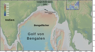
The Bengal Fan, also known as the Ganges Fan, is the largest submarine fan on Earth.

<span class="mw-page-title-main">Oceanic plateau</span> Relatively flat submarine region that rises well above the level of the ambient seabed

<span class="mw-page-title-main">Franciscan Complex</span> Late Mesozoic terrane of heterogeneous rocks in the California Coast Ranges

The Franciscan Complex or Franciscan Assemblage is a geologic term for a late Mesozoic terrane of heterogeneous rocks found throughout the California Coast Ranges, and particularly on the San Francisco Peninsula. It was named by geologist Andrew Lawson, who also named the San Andreas fault that defines the western extent of the assemblage.

<span class="mw-page-title-main">Back-arc basin</span> Submarine features associated with island arcs and subduction zones

A back-arc basin is a type of geologic basin, found at some convergent plate boundaries. Presently all back-arc basins are submarine features associated with island arcs and subduction zones, with many found in the western Pacific Ocean. Most of them result from tensional forces, caused by a process known as oceanic trench rollback, where a subduction zone moves towards the subducting plate. Back-arc basins were initially an unexpected phenomenon in plate tectonics, as convergent boundaries were expected to universally be zones of compression. However, in 1970, Dan Karig published a model of back-arc basins consistent with plate tectonics.

<span class="mw-page-title-main">Wrangellia Terrane</span> Geological area in northwestern North America

The evolution of tectonophysics is closely linked to the history of the continental drift and plate tectonics hypotheses. The continental drift/ Airy-Heiskanen isostasy hypothesis had many flaws and scarce data. The fixist/ Pratt-Hayford isostasy, the contracting Earth and the expanding Earth concepts had many flaws as well.

<span class="mw-page-title-main">Leech River Fault</span> British Columbia seismic fault

The Leech River Fault extends across the southern tip of Vancouver Island in British Columbia, Canada, creating the distinctively straight, narrow, and steep-sided valley, occupied by Loss Creek and two reservoirs, that runs from Sombrio Point due east to the Leech River, and then turns southeast to run past Victoria. It is a thrust fault that marks the northernmost exposure of the Crescent Terrane, where basalt of the Metchosin Igneous Complex is dragged under Vancouver Island by the subducting Juan de Fuca Plate. About ten kilometers north the nearly parallel San Juan Fault marks the southern limit of rock of the Wrangellia terrane, which underlies most of Vancouver Island. Between these two northeast-dipping thrust faults are the Leech River Complex and the Pandora Peak Unit. These, along with the Pacific Rim Complex further up the coast, are remnants of the Pacific Rim Terrane which was crushed between Wrangellia and Siletzia. The contact between the bottom of Wrangellia and the top of the subducted PRT continues northwest along the coast as the West Coast Fault, and southeast towards Victoria as the Survey Mountain Fault. The Leach River Fault (LRF) extends off-shore towards Cape Flattery, where the Crescent—Pacific Rim contact continues northwest as the Tofino Fault (TF).

<span class="mw-page-title-main">Project FAMOUS</span> Marine scientific exploration by manned submersibles of a diverging tectonic plate boundary

Project FAMOUS was the first-ever marine scientific exploration by manned submersibles of a diverging tectonic plate boundary on a mid-ocean ridge. It took place between 1971 and 1974, with a multi-national team of scientists concentrating numerous underwater surveys on an area of the Mid-Atlantic Ridge about 700 kilometers west of the Azores. By deploying new methods and specialized equipment, scientists were able to look at the sea floor in far greater detail than ever before. The project succeeded in defining the main mechanisms of creation of the median rift valley on the Mid-Atlantic Ridge, and in locating and mapping the zone of oceanic crustal accretion.

<span class="mw-page-title-main">Plate theory (volcanism)</span>

The plate theory is a model of volcanism that attributes all volcanic activity on Earth, even that which appears superficially to be anomalous, to the operation of plate tectonics. According to the plate theory, the principal cause of volcanism is extension of the lithosphere. Extension of the lithosphere is a function of the lithospheric stress field. The global distribution of volcanic activity at a given time reflects the contemporaneous lithospheric stress field, and changes in the spatial and temporal distribution of volcanoes reflect changes in the stress field. The main factors governing the evolution of the stress field are:

  1. Changes in the configuration of plate boundaries.
  2. Vertical motions.
  3. Thermal contraction.
<span class="mw-page-title-main">Marine geophysics</span>

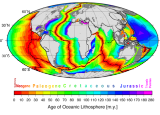
Marine geophysics is the scientific discipline that employs methods of geophysics to study the world's ocean basins and continental margins, particularly the solid earth beneath the ocean. It shares objectives with marine geology, which uses sedimentological, paleontological, and geochemical methods. Marine geophysical data analyses led to the theories of seafloor spreading and plate tectonics.

<span class="mw-page-title-main">East Luzon Trough</span> Oceanic trench

The East Luzon Trough is an oceanic trench north of the Philippine Trench and east of the island of Luzon. The trench is located near the Philippine orogeny and located in the southeastern region of the Philippine Sea Plate. The depth of the trough is 5,700 meters. The East Luzon Trough formed during the Eocene and Oligocene epoch, 40–24 million years ago.

<span class="mw-page-title-main">South Fiji Basin</span> Oceanic basin in the south-west Pacific Ocean between Fiji and New Zealand

The South Fiji Basin is a large 4 to 4.7 km deep oceanic basin in the south-west Pacific Ocean, south of Fiji. It was formed from the then Indo-Australian Plate and is delimited to the north west by the New Hebrides Trench, and the Hunter Fracture Zone, to the west by the Three Kings Ridge, to the east by the Lau-Colville Ridge, and to the south by the continental shelf of Zealandia.

References

  1. 1 2 3 4 P.P.E. Weaver; J. Thomson; P. M. Hunter (1987). Geology and Geochemistry of Abyssal Plains (PDF). Oxford: Blackwell Scientific Publications. p. x. ISBN   978-0-632-01744-7. Archived from the original (PDF) on 24 December 2010. Retrieved 27 June 2010.
  2. 1 2 Harris P.T., MacMillan-Lawler M., Rupp J., Baker E.K. (2014). "Geomorphology of the oceans". Marine Geology. 352: 4–24. Bibcode:2014MGeol.352....4H. doi:10.1016/j.margeo.2014.01.011.{{cite journal}}: CS1 maint: multiple names: authors list (link)
  3. Craig R. Smith; Fabio C. De Leo; Angelo F. Bernardino; Andrew K. Sweetman & Pedro Martinez Arbizu (2008). "Abyssal food limitation, ecosystem structure and climate change" (PDF). Trends in Ecology and Evolution. 23 (9): 518–528. doi:10.1016/j.tree.2008.05.002. PMID   18584909. Archived from the original (PDF) on 20 July 2011. Retrieved 27 June 2010.
  4. N.G. Vinogradova (1997). "Zoogeography of the Abyssal and Hadal Zones". The Biogeography of the Oceans. Advances in Marine Biology. Vol. 32. pp. 325–387. doi:10.1016/S0065-2881(08)60019-X. ISBN   978-0-12-026132-1.
  5. 1 2 3 Ivan Tolstoy & Maurice Ewing (October 1949). "North Atlantic hydrography and the mid-Atlantic Ridge". Geological Society of America Bulletin. 60 (10): 1527–40. Bibcode:1949GSAB...60.1527T. doi:10.1130/0016-7606(1949)60[1527:NAHATM]2.0.CO;2.
  6. Bruce C. Heezen, Maurice Ewing and D.B. Ericson (December 1951). "Submarine topography in the North Atlantic". Geological Society of America Bulletin. 62 (12): 1407–1417. Bibcode:1951GSAB...62.1407H. doi:10.1130/0016-7606(1951)62[1407:STITNA]2.0.CO;2. ISSN   0016-7606.
  7. Bruce C. Heezen, D.B. Ericson and Maurice Ewing (July 1954). "Further evidence for a turbidity current following the 1929 Grand banks earthquake". Deep-Sea Research. 1 (4): 193–202. Bibcode:1954DSR.....1..193H. doi:10.1016/0146-6313(54)90001-5.
  8. F.F. Koczy (1954). "A survey on deep-sea features taken during the Swedish deep-sea expedition". Deep-Sea Research. 1 (3): 176–184. Bibcode:1954DSR.....1..176K. doi:10.1016/0146-6313(54)90047-7.
  9. Bruce C. Heezen; Marie Tharp & Maurice Ewing (1962). "The Floors of the Oceans. I. The North Atlantic. Text to Accompany the Physiographic Diagram of the North Atlantic". In H. Caspers (ed.). Heezen, Bruce C., Marie Tharp, and Maurice Ewing: The Floors of the Oceans. I. The North Atlantic. Text to Accompany the Physiographic Diagram of the North Atlantic. With 49 fig., 30 plates. – New York, N.Y.: The Geological Society of America, Special Paper 65, 1959. 122 p. $10.00. Vol. 47. Weinheim: WILEY-VCH Verlag GmbH & Company. p. 487. doi:10.1002/iroh.19620470311 . Retrieved 26 June 2010.{{cite book}}: |journal= ignored (help)[ permanent dead link ]
  10. Bruce C. Heezen & A.S. Laughton (1963). "Abyssal plains". In M.N. Hill (ed.). The Sea. Vol. 3. New York: Wiley-Interscience. pp. 312–64.
  11. 1 2 Marc Wick (16 June 2010). "Record search for "abyssal plain"". Switzerland: GeoNames geographical database. Retrieved 27 June 2010.
  12. "Viewing the Earth from space". DK Millennium World Atlas: A Portrait of the Earth in the Year 2000. New York: Dorling Kindersley Publishing. 1 October 1999. pp. xvi–xvii. ISBN   978-0-7894-4604-6.
  13. Gabriele Uenzelmann‐Neben, Karsten Gohl, Axel Ehrhardt, Michael Seargent (1999). "Agulhas Plateau, SW Indian Ocean: New Evidence for Excessive Volcanism". Geophysical Research Letters. 26 (13): 1941–1944. Bibcode:1999GeoRL..26.1941U. doi: 10.1029/1999GL900391 . S2CID   129742780 . Retrieved 27 June 2010.{{cite journal}}: CS1 maint: multiple names: authors list (link)
  14. 1 2 3 Frank Scheckenbach; Klaus Hausmann; Claudia Wylezich; Markus Weitere; Hartmut Arndt (5 January 2010). "Large-scale patterns in biodiversity of microbial eukaryotes from the abyssal sea floor". Proceedings of the National Academy of Sciences. 107 (1): 115–120. Bibcode:2010PNAS..107..115S. doi: 10.1073/pnas.0908816106 . PMC   2806785 . PMID   20007768.
  15. Pedro Martínez Arbizu & Horst Kurt Schminke (18 February 2005). "DIVA-1 expedition to the deep sea of the Angola Basin in 2000 and DIVA-1 workshop 2003". Organisms Diversity & Evolution. 5 (Supplement 1): 1–2. doi: 10.1016/j.ode.2004.11.009 .
  16. Schmid, C., Brenke, N. & J.W. Wägele (2002). "On abyssal isopods (Crustacea: Isopoda: Asellota) from the Angola Basin: Eurycope tumidicarpus n.sp. and redescription of Acanthocope galathea Wolff, 1962". Organisms Diversity & Evolution. 2 (1): 87–88. doi: 10.1078/1439-6092-00030 .{{cite journal}}: CS1 maint: multiple names: authors list (link)
  17. Mursch, A., Brenke, N. & J.W. Wägele (2008). "Results of the DIVA-1 expedition of RV "Meteor" (Cruise M48:1): Three new species of Munnopsidae Sars, 1864 from abyssal depths of the Angola Basin (Crustacea: Isopoda: Asellota)" (PDF). In Pedro Martinez Arbizu; Saskia Brix (eds.). Bringing light into deep-sea biodiversity (Zootaxa 1866). Auckland, New Zealand: Magnolia Press. pp. 493–539. ISBN   978-1-86977-260-4 . Retrieved 27 June 2010.{{cite book}}: CS1 maint: multiple names: authors list (link)
  18. Affholder, M.; Valiron, F. (2001). Descriptive Physical Oceanography. CRC Press. p. 317. ISBN   978-0-203-96927-4.
  19. "Antarctica Detail". geonames.usgs.gov-us. Retrieved 2017-03-07.
  20. Encyclopædia Britannica (2010). "Blake Plateau". Encyclopædia Britannica Online . Retrieved 27 June 2010.
  21. 1 2 3 4 5 6 P.D.N. Hebert (Professor, Department of Zoology). "Towering Mountains". Canada's Aquatic Environments. Guelph, Ontario, Canada: CyberNatural Software, University of Guelph. Retrieved 27 June 2010.
  22. I.G. Priede; P.M. Bagley; S. Way; P.J. Herring; J.C. Partridge (July 2006). "Bioluminescence in the deep sea: Free-fall lander observations in the Atlantic Ocean off Cape Verde". Deep-Sea Research Part I: Oceanographic Research Papers. 53 (7): 1272–1283. Bibcode:2006DSRI...53.1272P. doi:10.1016/j.dsr.2006.05.004.
  23. "Enderby Plain". Geographic Names Information System . United States Geological Survey, United States Department of the Interior . Retrieved 27 June 2010.
  24. "Enderby Plain". Australian Antarctic Data Centre . Retrieved 27 June 2010.
  25. Mart, Yossi and Robertson, Alastair H. F. (1998). Eratosthenes Seamount: an oceanographic yardstick recording the Late Mesozoic-Tertiary geological history of the Eastern Mediterranean , in Robertson, A.H.F., Emeis, K.-C., Richter, C., and Camerlenghi, A. (eds.), Proceedings of the Ocean Drilling Program, Scientific Results, Vol. 160, Chapter 52, 701–708.
  26. Kempler, Ditza (1998). Eratosthenes Seamount: the possible spearhead of incipient continental collision in the Eastern Mediterranean , in Robertson, A.H.F., Emeis, K.-C., Richter, C., and Camerlenghi, A. (eds.), Proceedings of the Ocean Drilling Program, Scientific Results, Vol. 160, Chapter 53, 709–721.
  27. David A. Ross; Elazar Uchupi; Kenneth E. Prada; Joseph C. MacIlvaine (1974). "Bathymetry and Microtopography of Black Sea: Structure". Volume M 20: The Black Sea — Geology, Chemistry, and Biology (AAPG Special Volumes ed.). American Association of Petroleum Geologists. pp. 1–10. Retrieved 27 June 2010.
  28. Dumitru Dorogan & Diaconeasa Danut (2002). "The Black Sea Romanian coastal zone: a general survey of the erosion process". In Richard C. Ragaini (ed.). International Seminar on Nuclear War and Planetary Emergencies: 26th Session . Singapore: World Scientific Publishing Company. pp.  145–164. ISBN   978-981-238-092-0.
  29. Vittorio Barale (2008). "The European marginal and enclosed seas: an overview". In Vittorio Barale; Martin Gade (eds.). Remote Sensing of the European Seas. Heidelberg: Springer. pp. 3–22. ISBN   978-1-4020-6771-6.
  30. Bernd Andeweg (2002). Cenozoic tectonic evolution of the Iberian Peninsula, causes and effects of changing stress fields (PhD Thesis). Vrije Universiteit Amsterdam. Retrieved 27 June 2010.
  31. Kuhnt W, Collins ES (1996). "8. Cretaceous to Paleogene benthic foraminifers from the Iberia abyssal plain" (PDF). Proceedings of the Ocean Drilling Program, Scientific Results. Proceedings of the Ocean Drilling Program. 149: 203–216. doi:10.2973/odp.proc.sr.149.254.1996 . Retrieved 27 June 2010.
  32. "JOIDES Basin". Geographic Names Information System . United States Geological Survey, United States Department of the Interior . Retrieved 2018-08-14.
  33. Encyclopædia Britannica (2010). "Seychelles-Mauritius Plateau". Encyclopædia Britannica Online . Retrieved 27 June 2010.
  34. Geoscience Australia: Naturaliste Plateau Archived 2012-07-23 at archive.today . Retrieved 18 June 2010.
  35. OceanLab (2000). "The Porcupine Seabight and Abyssal Plain". Newburgh, Aberdeenshire, UK: University of Aberdeen. Archived from the original on 2009-07-22. Retrieved 27 June 2010.
  36. Marine Biodiversity & Ecosystem Functioning (18 November 2004). "Porcupine Abyssal Plain" (PDF). Horta, Azores: University of the Azores. Retrieved 27 June 2010.
  37. Thomas S. Ahlbrandt (2001) The Sirte Basin Province of Libya—Sirte-Zelten Total Petroleum System. U.S. Geological Survey Bulletin 2202–F, U.S. Geological Survey, U.S. Department of the Interior. Accessed on 27 June 2010.
  38. Nick Mortimer & Dave Parkinson (1996). "Hikurangi Plateau: A Cretaceous large igneous province in the southwest Pacific Ocean". Journal of Geophysical Research. 101 (B1): 687–696. Bibcode:1996JGR...101..687M. doi:10.1029/95JB03037 . Retrieved 27 June 2010.
  39. Kaj Hoernle; Reinhard Werner; Folkmar Hauff; Paul van den Bogaard (2005). "The Hikurangi Oceanic Plateau: A Fragment of the Largest Volcanic Event on Earth" (PDF). IFM – GEOMAR Yearbook 2002–2004. Kiel, Germany: Leibniz Institute of Marine Sciences at Kiel University (IFM-GEOMAR). pp. 51–54. Archived from the original (PDF) on 2007-03-29. Retrieved 27 June 2010.
  40. Te Ara – the Encyclopedia of New Zealand (4 March 2010). Hikurangi Plateau. Wellington, New Zealand: Te Ara: The Encyclopedia of New Zealand. ISBN   978-0-478-18451-8 . Retrieved 27 June 2010.
  41. De Broyer, C., Nyssen, F. & P. Dauby (July–August 2004). "The crustacean scavenger guild in Antarctic shelf, bathyal and abyssal communities". Deep-Sea Research Part II: Topical Studies in Oceanography. 51 (14–16): 1733–1752. Bibcode:2004DSRII..51.1733D. doi:10.1016/j.dsr2.2004.06.032. hdl: 2268/34147 .{{cite journal}}: CS1 maint: multiple names: authors list (link)
  42. Daniel Sarewitz (November 1983). "Seven Devils terrane: Is it really a piece of Wrangellia?". Geology. 11 (11): 634–637. Bibcode:1983Geo....11..634S. doi:10.1130/0091-7613(1983)11<634:SDTIIR>2.0.CO;2. ISSN   0091-7613.
  43. WESLEY K. WALLACE, CATHERINE L. HANKS and JOHN F. ROGERS (November 1989). "The southern Kahiltna terrane: Implications for the tectonic evolution of southwestern Alaska". Geological Society of America Bulletin. 101 (11): 1389–1407. Bibcode:1989GSAB..101.1389W. doi:10.1130/0016-7606(1989)101<1389:TSKTIF>2.3.CO;2.
  44. ROGERS, Robert K. & SCHMIDT, Jeanine M. (May 15, 2002). "METALLOGENY OF THE WRANGELLIA TERRANE IN THE TALKEETNA MOUNTAINS, SOUTHERN ALASKA". Cordilleran Section – 98th Annual Meeting. Alaskan Tectonics, Structure, and Stratigraphy. Retrieved 27 June 2010.
  45. Greene, A.R., Scoates, J.S., Weis, D. and Israel, S. (2005). "Flood basalts of the Wrangellia Terrane, southwest Yukon: Implications for the formation of oceanic plateaus, continental crust and Ni-Cu-PGE mineralization" (PDF). In D.S. Emond; L.L. Lewis; G.D. Bradshaw (eds.). Yukon Exploration and Geology. Yukon Geological Survey. pp. 109–120. Retrieved 27 June 2010.{{cite book}}: CS1 maint: multiple names: authors list (link)
  46. WARREN J. NOKLEBERG, DAVID L. JONES and NORMAN J. SILBERLING (1985). "Origin and tectonic evolution of the Maclaren and Wrangellia terranes, eastern Alaska Range, Alaska". Geological Society of America Bulletin. 96 (10): 1257–1270. Bibcode:1985GSAB...96.1251N. doi:10.1130/0016-7606(1985)96<1251:OATEOT>2.0.CO;2.
  47. Jeffrey M. Trop; Kenneth D. Ridgway; Jeffrey D. Manuszak; Paul Layer (June 2002). "Mesozoic sedimentary-basin development on the allochthonous Wrangellia composite terrane, Wrangell Mountains basin, Alaska: A long-term record of terrane migration and arc construction". Geological Society of America Bulletin. 114 (6): 693–717. Bibcode:2002GSAB..114..693T. doi:10.1130/0016-7606(2002)114<0693:MSBDOT>2.0.CO;2. ISSN   0016-7606.
  48. ISRAEL, Steve A. & MORTENSEN, James K. (8 May 2009). "STRATIGRAPHIC AND TECTONIC RELATIONSHIPS OF THE PALEOZOIC PORTION OF WRANGELLIA". Cordilleran Section Meeting – 105th Annual Meeting. Paleozoic Paleogeography of Cordilleran Terranes III. Retrieved 27 June 2010.
  49. A.R. Greene, J.S. Scoates & D. Weis (2005). "Wrangellia Terrane on Vancouver Island, British Columbia: Distribution of Flood Basalts with Implications for Potential Ni-Cu-PGE Mineralization in Southwestern British Columbia" (PDF). British Columbia Geological Survey. Geological Fieldwork 2004: 209–220. Retrieved 27 June 2010.
  50. oceanic plateau. (2008). In Encyclopædia Britannica. Retrieved June 27, 2010, from Encyclopædia Britannica Online.
  51. 1 2 Andrew C. Kerr (July 1998). "Oceanic plateau formation: A cause of mass extinction and black shale deposition around the Cenomanian-Turonian boundary?". Journal of the Geological Society. 155 (4): 619–626. Bibcode:1998JGSoc.155..619K. doi:10.1144/gsjgs.155.4.0619. ISSN   0016-7649. S2CID   129178854. Archived from the original on 5 November 2011. Retrieved 27 June 2010.
  52. Uenzelmann-Neben, G., K. Gohl, A. Ehrhardt, and M. Seargent (1999). Agulhas Plateau, SW Indian Ocean: New Evidence for Excessive Volcanism, Geophysical Research Letters, 26(13), 1941–1944.

Further reading

Map all coordinates using: OpenStreetMap