Queen's Wood

Last updated
Queen's Wood
Queen's Wood Cafe.jpg
The Queen's Wood Cafe
Queen's Wood
Type Local Nature Reserve/Woodland
Area52 acres (21 ha)
Opened1898 (as public park)
Operated by London Borough of Haringey
Open24 hours

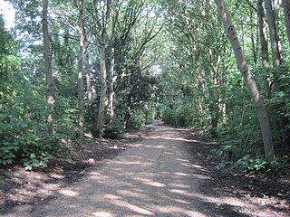
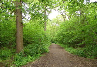
Queen's Wood is a 52-acre (21 hectare) area of ancient woodland in the London Borough of Haringey, abutting Highgate Wood and lying between East Finchley, Highgate, Muswell Hill and Crouch End. It was originally part of the ancient Forest of Middlesex which covered much of London, Hertfordshire and Essex and was mentioned in the Domesday Book. It is now one of three Local Nature Reserves in the London Borough of Haringey. It is situated a few minutes' walk from Highgate tube station.

Haringey contains four ancient woods. These are Highgate Wood, Queen's Wood, Coldfall Wood and Bluebell Wood. All are shown on John Rocque's 1754 Map of Middlesex.

Queen's Wood was once called Churchyard Bottom Wood, and was originally part of the Great Forest of Middlesex. It was said to be the site of a plague pit during the Great Plague of London, although evidence suggests if there was a plague pit it was just outside the boundaries of the current wood. [1] In 1898 it was purchased from the Ecclesiastical Commissioners by Hornsey Urban District Council, opened to the public by Princess Helena, Duchess of Albany, and renamed Queen's Wood in honour of Queen Victoria. [2]

Queen's Wood in late July 2006 060729 Queen's Wood Oaks.JPG
Queen's Wood in late July 2006

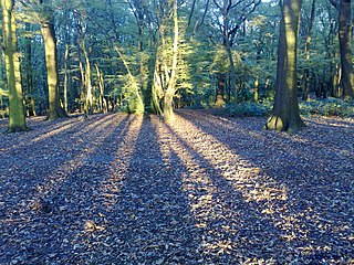
The wood is an ancient oak-hornbeam woodland, which features English oak and occasional beech which provide a canopy above cherry, field maple, hazel, holly, hornbeam, midland hawthorn, mountain ash and both species of lowland birch. The scarce Wild Service Tree (which is evidence of the Woods's ancient origin) is scattered throughout the wood. The Wood has a small adventure playground, but no park or playing fields, and has never been subjected to intensive management of the type practised at Highgate Wood and accordingly there is greater diversity of flora and fauna - Bantock (1984) found a significantly greater number of ground feeding birds present in the Wood when compared to Highgate Wood, which he attributed to the greater structural diversity and denser shrub layer present. Queen's Wood is a Local Nature Reserve [3] [4] and a Site of Metropolitan Importance for Nature Conservation. [5]

The ground flora is particularly rich given its proximity to central London (the wood is within a six-mile radius of Charing Cross railway station). It includes a large population of wood anemone, goldilocks buttercup and wood sorrel, yellow pimpernel and square-stemmed St John's wort. A survey conducted in 1984 [6] noted 39 distinct herbaceous species and 15 different grasses native to the wood, in addition to some 23 species of tree and shrub.

A small paddling pool which had fallen into disuse has been converted into a pond with wild aquatic plants. This was with the assistance of the Friends of Queens Wood society.

Despite fairly high levels of disturbance, the bird life is diverse and includes breeding pairs of at least 27 species, including the endangered song thrush and two species of woodpecker. [7] Over one hundred species of spiders have been spotted and a nationally rare jewel beetle is widespread.[ citation needed ]

The park is also the source of the Moselle, a stream that runs across parts of North London on its way (nowadays via Pymmes Brook) to the River Lea in Tottenham. [8]

Related Research Articles

<span class="mw-page-title-main">Hornsey</span> Area of London, England

Hornsey is a district of north London, England, in the London Borough of Haringey. It is an inner-suburban, for the most part residential, area centred 10 km (6.2 mi) north of Charing Cross. It adjoins green spaces Queen's Wood to the west and Alexandra Park to the north, and lies in the valley of the now-culverted River Moselle. The central core of the area is known as Hornsey Village.

<span class="mw-page-title-main">Muswell Hill</span> Suburb in north London, England

Muswell Hill is a suburban district of the London Borough of Haringey, north London. The hill, which reaches over 100 m (330 ft) above sea level, is situated 5+12 miles north of Charing Cross.

<span class="mw-page-title-main">London Borough of Haringey</span> London borough in United Kingdom

The London Borough of Haringey is a London borough in North London, classified by some definitions as part of Inner London, and by others as part of Outer London. It was created in 1965 by the amalgamation of three former boroughs. It shares borders with six other London boroughs. Clockwise from the north, they are: Enfield, Waltham Forest, Hackney, Islington, Camden, and Barnet.

<span class="mw-page-title-main">Crouch End</span> Human settlement in England

Crouch End is an area of North London, approximately five miles (8 km) from the City of London in the western half of the borough of Haringey. It is within the Hornsey postal district (N8). It has been described by the BBC as one of "a new breed of urban villages" in London. In 2023, it was voted the best place to live in London by the Sunday Times, saying "A creative edge and friendly neighbours give this lofty northern enclave social capital in the capital".

<span class="mw-page-title-main">Parkland Walk</span> 2.5-mile linear green walkway in London

The Parkland Walk is a 3.1-mile (5.0 km) linear green pedestrian and cycle route in London, which follows the course of the railway line that used to run between Finsbury Park and Alexandra Palace, through Stroud Green, Crouch End, Highgate and Muswell Hill. It is often mistakenly described as 4.5 miles long, but even taking in the gap between the two sections it still only totals 3.1 miles (5.0 km). The route follows the bridges and cuttings of the line, but avoids the closed surface section of Highgate station and its adjoining tunnels, which are closed to walkers for safety reasons. The walk is almost all in Haringey, but a short stretch between Crouch Hill and Crouch End Hill is in Islington and this section incorporates Crouch Hill Park.

<span class="mw-page-title-main">Municipal Borough of Hornsey</span>

The Municipal Borough of Hornsey was a local government district in east Middlesex from 1867 to 1965.

<span class="mw-page-title-main">Coldfall Wood</span> Ancient woodland in Muswell Hill, North London

Coldfall Wood is an ancient woodland in Muswell Hill, North London. It covers an area of approximately 14 hectares and is surrounded by St Pancras and Islington Cemetery, the East Finchley public allotments, and the residential streets Creighton Avenue and Barrenger Road. It is the site of the discoveries which first led to the recognition that glaciation had once reached southern England. It was declared a local nature reserve in 2013, and is also a Site of Borough Importance for Nature Conservation, Grade 1.

<span class="mw-page-title-main">Highgate Wood</span> An ancient woodland in North London

Highgate Wood is a 28 hectare area of ancient woodland in North London, lying between East Finchley, Highgate and Muswell Hill. It was originally part of the ancient Forest of Middlesex which covered much of London, Hertfordshire and Essex and was mentioned in the Domesday Book. It lies in the London Borough of Haringey, but is owned and managed by the City of London Corporation.

Hornsey was an ancient parish in the county of Middlesex. It was both a civil parish, used for administrative purposes, and an ecclesiastical parish of the Church of England.

<span class="mw-page-title-main">Finchley Common</span> Common land in Middlesex, north of London

Finchley Common was an area of land in Middlesex, north of London, and until 1816, the boundary between the parishes of Finchley, Friern Barnet and Hornsey.

<span class="mw-page-title-main">A1 in London</span> The section of A1 road in Greater London

The A1 in London is the southern part of the A1 road. It starts at Aldersgate in the City of London, passing through the capital to Borehamwood on the northern fringe of Greater London, before continuing to Edinburgh. The road travels through the City and three London boroughs: Islington, Haringey and Barnet, which include the districts of Islington, Holloway, Highgate, Hendon and Mill Hill, and travels along Upper Street and Holloway Road, crossing the North Circular Road in Hendon, a district in the London Borough of Barnet.

<span class="mw-page-title-main">South Hornsey</span>

South Hornsey was a local government district in Middlesex, England from 1865 to 1900.

<span class="mw-page-title-main">Cherry Tree Wood</span> Park in London, England

Cherry Tree Wood is a 5.3-hectare park in East Finchley in the London Borough of Barnet. It is a Site of Local Importance for Nature Conservation. Located opposite East Finchley Underground station, it contains woodland and grassland, a playground, tennis courts, a cafe and toilets.

<span class="mw-page-title-main">Stanmore Country Park, London</span>

Stanmore Country Park is a 30.7-hectare (76-acre) public park, Local Nature Reserve and Site of Metropolitan Importance for Nature Conservation in Stanmore in the London Borough of Harrow. It is owned and managed by Harrow London Borough Council.

<span class="mw-page-title-main">Scratchwood</span>

Scratchwood is an extensive, mainly wooded, country park in Mill Hill in the London Borough of Barnet. The 57-hectare site is a Site of Metropolitan Importance for Nature Conservation and together with the neighbouring Moat Mount Open Space. It is a Local Nature Reserve.

<span class="mw-page-title-main">Coppetts Wood and Scrublands</span> Nature reserve in the London Borough of Barnet

Coppetts Wood and Scrublands is a 14.5-hectare (36-acre) Site of Borough Importance for Nature Conservation, Grade I, between Muswell Hill and Friern Barnet in the London Borough of Barnet. It is part of the Coppetts Wood and Glebelands Local Nature Reserve.

<span class="mw-page-title-main">Oak Hill Wood</span>

Oak Hill Wood is a 10-hectare Local Nature Reserve (LNR) and a Site of Borough Importance for Nature Conservation Grade I, in East Barnet, London. It is owned by the London Borough of Barnet, and part of it is a 5.5-hectare nature reserve managed by the London Wildlife Trust.

<span class="mw-page-title-main">Monken Hadley Common</span> Nature Reserve in Barnet, London

Monken Hadley Common lies within the Monken Hadley Conservation Area, and is listed as a “Site of Borough Importance for Nature Conservation, Grade I,” by the London Borough of Barnet. It is registered common land, and it is owned by the Trustees of Monken Hadley Common.

<span class="mw-page-title-main">Old Park Wood</span>

Old Park Wood is a 16.7-hectare (41-acre) Site of Special Scientific Interest in Harefield in the London Borough of Hillingdon. The south-east part is an 8-hectare (20-acre) nature reserve owned and managed by the Hertfordshire and Middlesex Wildlife Trust.

<span class="mw-page-title-main">Big Wood and Little Wood</span> Small forested areas in London, England

Big Wood and Little Wood are two patches of woodland in Hampstead Garden Suburb in the London Borough of Barnet. They are a Site of Borough Importance for Nature Conservation, Grade 1, and a Local Nature Reserve. Big Wood is 7.3 hectares and Little Wood is 1.2 hectares.

References

  1. Hacker, Michael (July 2017). "The History and Archaeology of Queen's Wood" (PDF). Friends of Queen's Wood. Retrieved 22 April 2022.
  2. "A History of the County of Middlesex: Volume 6: Friern Barnet, Finchley, Hornsey with Highgate". British History Online. Institute of Historical Research. Retrieved 29 December 2013.
  3. "Queen's Wood". Local Nature Reserves. Natural England. 6 March 2013. Retrieved 22 January 2014.
  4. "Map of Queen's Wood". Local Nature Reserves. Natural England. Retrieved 29 December 2013.
  5. "Parkland Walk, Queen's Wood and Highgate Wood". Greenspace Information for Greater London. 2006. Archived from the original on 24 December 2012. Retrieved 10 September 2012.
  6. Latimer, William (1984), Highgate and Queen's Woods. A Survey of their Biology and Management ("Woodland Contrasts"), The London Wildlife Trust., pp. 14–15
  7. Darrell-Lambert, David (January 2020). "Queen's Wood Breeding Bird Survey 2019" (PDF). Friends of Queen's Wood. Retrieved 22 April 2022.
  8. "Testing times for the health of Haringey's Moselle River - Thames21" . Retrieved 2021-02-15.

51°34′55″N0°08′35″W / 51.582°N 0.143°W / 51.582; -0.143