
The Battle of Roundway Down was fought on 13 July 1643 at Roundway Down near Devizes, in Wiltshire during the First English Civil War. Despite being outnumbered and exhausted after riding overnight from Oxford, a Royalist cavalry force under Lord Wilmot won a crushing victory over the Parliamentarian Army of the West under Sir William Waller.

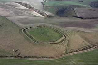
Uffington Castle is an early Iron Age univallate hillfort in Oxfordshire, England. It covers about 32,000 square metres and is surrounded by two earth banks separated by a ditch with an entrance in the western end. A second entrance in the eastern end was apparently blocked up a few centuries after it was built. The original defensive ditch was V-shaped with a small box rampart in front and a larger one behind it. Timber posts stood on the ramparts. Later the ditch was deepened and the extra material dumped on top of the ramparts to increase their size. A parapet wall of sarsen stones lined the top of the innermost rampart. It is very close to the Uffington White Horse on White Horse Hill.

Westbury White Horse or Bratton White Horse is a hill figure on the escarpment of Salisbury Plain, approximately 1.5 mi (2.4 km) east of Westbury in Wiltshire, England. Located on the edge of Bratton Downs and lying just below an Iron Age hill fort, it is the oldest of several white horses carved in Wiltshire. It was restored in 1778, an action which may have obliterated another horse that had occupied the same slope. A contemporary engraving from around 1772 appears to show a horse facing in the opposite direction that was rather smaller than the present figure. There is, however, no documentation or other evidence for the existence of a chalk horse at Westbury before 1772.
Liddington Castle, locally called Liddington Camp, is a late Bronze Age and early Iron Age univallate hillfort in Liddington parish in the English county of Wiltshire, and a scheduled monument.

Beacon Hill is near the village of Burghclere and Watership Down, in north Hampshire. The hill's name is derived from the fact that it was one of many Beacon Hills in England and beyond. This hill was once the site of the most famous beacon in Hampshire. It is 261 metres high and has one of England's most well known hill forts on its slopes, visible from the main A34 road which passes close by. From there, outstanding views of the surrounding area and much of Hampshire may be obtained. The site is open to the public and managed by Hampshire County Council. It is an 80.7-hectare (199-acre) biological Site of Special Scientific Interest called Burghclere Beacon and a Nature Conservation Review site, Grade I.

Figsbury Ring is an 11.2 hectare biological Site of Special Scientific Interest in Wiltshire, England, notified in 1975. It is owned and managed by the National Trust.
St. Catherine's Hill is a chalk downland hill and 43-hectare (110-acre) biological Site of Special Scientific Interest on the outskirts of Winchester in Hampshire, England. It is owned by Winchester College but open to the public. It is managed by Hampshire and Isle of Wight Wildlife Trust, and topped by an Iron Age hillfort, a scheduled monument. In the Black Death, plague pits were dug in the dry valley on the south side of the hill. In the Early modern period, a mizmaze was cut on the hilltop. Winchester College football used to be played on the hill; in an old custom, members of the college assemble on the hill every year, early in the morning.

Roundway is a hamlet, ward and former civil parish adjacent to Devizes in the English county of Wiltshire. The hamlet lies about 1+1⁄4 miles (2.0 km) northeast of Devizes town centre.

Ladle Hill is a 10.5-hectare (26-acre) biological Site of Special Scientific Interest west of Kingsclere in Hampshire. It is also a Scheduled Monument.

Blewburton Hill is the site of an Iron Age hillfort located in Oxfordshire, in the southeast of England. It was a univallate hillfort. The area is mostly farmland with some small areas of wooded copse to the south and the northeast. The hill fort may have been occupied from the 4th century BC to the 1st century BC, and replaced a small settlement surrounded by a stockade, which is estimated to have been built in the 5th or 6th century BC.

Woolbury, or Woolbury Ring, is the site of an Iron Age univallate hill fort on Stockbridge Down, Hampshire, England.

Battlesbury Camp is the site of an Iron Age bivallate hill fort on Battlesbury Hill near the town of Warminster in Wiltshire, South West England. Excavations and surveys at the site have uncovered various finds and archaeological evidence.

Scratchbury Camp is the site of an Iron Age univallate hillfort on Scratchbury Hill, overlooking the Wylye valley about 1 km northeast of the village of Norton Bavant in Wiltshire, England. The fort covers an area of 37 acres (15 ha) and occupies the summit of the hill on the edge of Salisbury Plain, with its four-sided shape largely following the natural contours of the hill.

Chiselbury is the site of an Iron Age univallate hillfort in Wiltshire, England. The hillfort is sub-circular in plan, and encloses an area of approximately 10.5 acres (460,000 sq ft). It is defined by an earthen rampart up to 3.6 metres (12 ft) in height and an external ditch, up to a maximum of 1.6 metres (5.2 ft) in depth. A gap in the south-eastern side of the rampart, and a corresponding causeway across the ditch, is thought to be the original entrance and is associated with a small D-shaped embanked enclosure, which is apparently visible on aerial photographs. Although the enclosure has subsequently been degraded by ploughing, it is still apparent as a series of low earthworks.

Sidbury Hill, or Sidbury Camp, is the site of an Iron Age bivallate hillfort on the eastern edge of Salisbury Plain in Wiltshire, England. The site is sub-triangular in shape, approximately 17 acres (6.9 ha) in area, and is constructed on the site of a Neolithic settlement.
Hillforts in Britain refers to the various hillforts within the island of Great Britain. Although the earliest such constructs fitting this description come from the Neolithic British Isles, with a few also dating to later Bronze Age Britain, British hillforts were primarily constructed during the British Iron Age. Some of these were apparently abandoned in the southern areas that were a part of Roman Britain, although at the same time, those areas of northern Britain that remained free from Roman occupation saw an increase in their construction. Some hillforts were reused in the Early Middle Ages, and in some rarer cases, into the Later Medieval period as well. By the early modern period, these had essentially all been abandoned, with many being excavated by archaeologists in the nineteenth century onward.

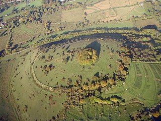
Bratton Castle is a bivallate Iron Age built hill fort on Bratton Down, at the western edge of the Salisbury Plain escarpment. The hill fort comprises two circuits of ditch and bank which together enclose a pentagonal area of 9.3 hectares.

Devizes White Horse, officially known as the Devizes Millennium White Horse, is a chalk hill figure of a horse located on Bank Field, an escarpment at Roundway Hill, on the outskirts of the town of Devizes above the hamlet of Roundway, Wiltshire, England; it is about ½ mile north of Roundway. It was cut in 1999 to celebrate the forthcoming third millennium, and is based on a design of another white horse hill figure, which was also known as Devizes White Horse, or sometimes The Snobs Horse, which was very close to the present horse as it was also on Roundway Hill beneath the Oliver's Castle hill fort. Traces of the Snobs Horse can still be seen under the right conditions.

Knap Hill lies on the northern rim of the Vale of Pewsey, in northern Wiltshire, England, about a mile north of the village of Alton Priors. At the top of the hill is a causewayed enclosure, a form of Neolithic earthwork that was constructed in England from about 3700 BC onwards, characterized by the full or partial enclosure of an area with ditches that are interrupted by gaps, or causeways. Their purpose is not known: they may have been settlements, or meeting places, or ritual sites of some kind. The site has been scheduled as an ancient monument.

Torberry Hill is an Iron Age hillfort in the county of West Sussex, in southern England. It is a Scheduled Ancient Monument, with a list entry identification number of 1015966. The hill fort is located within the parish of Harting, within the South Downs National Park. The hill includes the remains of an Early Iron Age univallate hill fort, a Middle Iron Age promontory fort and a post-medieval post mill. The hill is a chalk spur projecting northwards from the South Downs.


