Related Research Articles

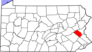
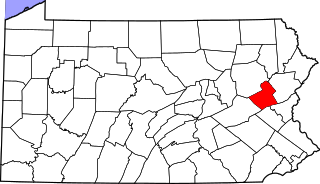
Northampton County is a county in the Commonwealth of Pennsylvania. As of the 2020 census, the population was 312,951. Its county seat is Easton. The county was formed in 1752 from parts of Bucks County. Its namesake was the county of Northamptonshire in England, and the county seat of Easton was named for the country house Easton Neston in Northamptonshire.
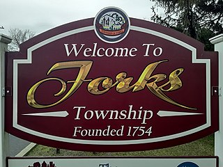
Forks Township is a township in Northampton County, Pennsylvania. The population of Forks Township was 14,721 as of the 2010 census. It is part of the Lehigh Valley metropolitan area, which had a population of 861,899 and was the 68th-most populous metropolitan area in the U.S. as of the 2020 census. The township is home to the global headquarters of Crayola, founded in 1885, a global arts supply company and the world's leading manufacturer of crayons.
Shimerville is an unincorporated community, located on Pennsylvania Route 100 and Pennsylvania Route 29 South in Upper Milford Township in Lehigh County, Pennsylvania. The community is located outside and to the south of Macungie and to the west of Vera Cruz. It is part of the Lehigh Valley, which has a population of 861,899 and is the 68th most populous metropolitan area in the U.S. as of the 2020 census.

Honeydew is an unincorporated community in Humboldt County, California. It is located 17 miles (27 km) south of Scotia, at an elevation of 322 feet, 15 miles (24 km) from the Pacific Ocean in the Lost Coast, near the King Range. It has a general store, elementary school, post office, and a few houses nearby. Many of the locals live in the hills surrounding the Mattole valley, named after the Mattole River which runs through the valley. The ZIP code is 95545 and the community is inside area code 707.

Summit Lawn is a small unincorporated village in Lehigh County, Pennsylvania. Summit Lawn is part of the Lehigh Valley, which has a population of 861,899 and is the 68th most populous metropolitan area in the U.S. as of the 2020 census.
Eagle Point is the area immediately surrounding the intersection of Pennsylvania Route 145 and Pennsylvania Route 329 in Whitehall Township in Lehigh County, Pennsylvania. It is located between the communities of Egypt and Cementon and is part of the Lehigh Valley metropolitan area in eastern Pennsylvania.
Limeport is a small unincorporated community on the Saucon Creek in Lower Milford Township and Upper Saucon Township in Lehigh County, Pennsylvania. It is part of the Lehigh Valley, which has a population of 861,899 and is the 68th most populous metropolitan area in the U.S., as of the 2020 census.
Hosensack (HOE-zen-sak) is an unincorporated community in Lower Milford Township in Lehigh County, Pennsylvania. It is part of the Lehigh Valley, which has a population of 861,899 and was the 68th most populous metropolitan area in the U.S. as of the 2020 census.
Ironton is a village in North Whitehall Township in Lehigh County, Pennsylvania. It is part of the Lehigh Valley, which has a population of 861,899 and was the 68th most populous metropolitan area in the U.S. as of the 2020 census.
Newburg is a village located in Lower Nazareth Township in Northampton County, Pennsylvania. The village is located at the eastern terminus of Route 946 at Route 191. Newburg is part of the Lehigh Valley metropolitan area, which had a population of 861,899 and was the 68th most populous metropolitan area in the U.S. as of the 2020 census.

Schoenersville is a suburban village split between Hanover Township in Lehigh County and Hanover Township in Northampton County, Pennsylvania. It is pronounced "SHOO-nerz-vil" and is part of the Lehigh Valley metropolitan area, which has a population of 861,899 and is the 68th most populous metropolitan area in the U.S. as of the 2020 census.
Colesville is a suburban village located on Route 378 in Upper Saucon Township in Lehigh County and Lower Saucon Township in Northampton County, Pennsylvania. Colesville is part of the Lehigh Valley, which had a population of 861,899 and was the 68th most populous metropolitan area in the U.S. as of the 2020 census.
Andreas is a village in the southeast corner of Schuylkill County, Pennsylvania, in West Penn Township on Route 895. A small part of Andreas is also in East Penn Township in Carbon County. The Lizard Creek flows eastward through the village to the Lehigh River. Andreas lies at the northern foot of Blue Mountain in ZIP Code 18211.
Flicksville is a village located in Northampton County, Pennsylvania. It is located 75 miles (121 km) west of New York City and is part of the Lehigh Valley metropolitan area, which had a population of 861,899 and was the 68th most populous metropolitan area in the U.S. as of the 2020 census.
Seidersville is a suburban Lehigh Valley village on Route 378 in Lower Saucon Township in Northampton County, Pennsylvania. It is part of the Lehigh Valley metropolitan area, which had a population of 861,899 and was the 68th most populous metropolitan area in the U.S. as of the 2020 census.

Gauff Hill is an unincorporated community in extreme eastern Salisbury Township in Lehigh County, Pennsylvania. It is part of the Lehigh Valley, which has a population of 861,899 and was the 68th-most populous metropolitan area in the U.S. as of the 2020 census.

Christian Springs is an unincorporated community in Upper Nazareth Township, Pennsylvania. It is located between the boroughs of Bath and Narareth at the junction of Pennsylvania State Routes 248 and 946. It is part of the Lehigh Valley metropolitan area, which had a population of 861,899 and was the 68th most populated metropolitan area in the U.S. as of the 2020 census.
Scherersville is an unincorporated community in Lehigh County, Pennsylvania. It is located on Jordan Creek, mainly in South Whitehall Township and also in Whitehall Township. Schereresville is part of the Lehigh Valley, which has a population of 861,899 and is the 68th most populous metropolitan area in the U.S. as of the 2020 census.
Treichlers is an unincorporated community along the Lehigh River in Lehigh Township in Northampton County, Pennsylvania. The village is part of the Lehigh Valley metropolitan area, which had a population of 861,899 and was the 68th most populous metropolitan area in the U.S. as of the 2020 census.
Emerald is an unincorporated exurban community in Washington Township in Lehigh County, Pennsylvania. It is located two miles west of Slatington. Emerald is part of the Lehigh Valley, which has a population of 861,899 and was the 68th most populous metropolitan area in the U.S. as of the 2020 census.
References
- ↑ "ZIP Code 18040". unitedstateszipcodes.org. Retrieved 9 April 2023.
Places adjacent to Zucksville, Pennsylvania | ||||||||||||||||
|---|---|---|---|---|---|---|---|---|---|---|---|---|---|---|---|---|
| ||||||||||||||||
Municipalities and communities of Northampton County, Pennsylvania, United States | ||
|---|---|---|
| Region |  | |
| Cities | ||
| Boroughs | ||
| Townships | ||
| CDPs | ||
| Other communities | ||
| Notable people | ||
| Culture | ||
| Footnotes | ‡This populated place also has portions in an adjacent county or counties | |
Coordinates: 40°43′07″N75°14′40″W / 40.71861°N 75.24444°W
| | This Northampton County, Pennsylvania state location article is a stub. You can help Wikipedia by expanding it. |