Bath, Pennsylvania

Last updated

Bath, Pennsylvania
Borough
Bath, Pennsylvania.jpg
Bath, Pennsylvania in December 2009
Bath PA Logo.png
Motto(s): 
History, Nestled with Friendship
Northampton County Pennsylvania Incorporated and Unincorporated areas Bath Highlighted.svg
Location of Bath in Northampton County, Pennsylvania (left) and of Northampton County in Pennsylvania (right)
USA Pennsylvania location map.svg
Red pog.svg
Bath
Location of Bath in Pennsylvania
Usa edcp location map.svg
Red pog.svg
Bath
Bath (the United States)
Coordinates: 40°43′36″N75°23′25″W / 40.72667°N 75.39028°W / 40.72667; -75.39028
Country Flag of the United States.svg  United States
State Flag of Pennsylvania.svg  Pennsylvania
County Northampton
Founded1737
Named for Bath, Somerset, England
Government
  MayorFiorella Reginelli Mirabito
Area
[1]
  Borough0.91 sq mi (2.36 km2)
  Land0.90 sq mi (2.34 km2)
  Water0.01 sq mi (0.02 km2)
Elevation
432 ft (132 m)
Population
 (2020) [2]
  Borough2,682
  Density2,947/sq mi (1,138/km2)
   Metro
865,310 (US: 68th)
Time zone UTC-5 (EST)
  Summer (DST) UTC-4 (EDT)
ZIP Code
18014
Area code(s) 610 and 484
FIPS code 42-04432
Primary airport Lehigh Valley International Airport
Major hospital Lehigh Valley Hospital–Cedar Crest
School district Northampton Area
Website Borough Website

Bath is a borough in Northampton County, Pennsylvania. As of the 2020 census, Bath had a population of 2,808. It is part of the Lehigh Valley metropolitan area, which had a population of 861,899 and was the 68th-most populous metropolitan area in the U.S. as of the 2020 census.

Contents

History

Bath is located at the head of the Monocacy Creek in an area of the Lehigh Valley that was once rich in agriculture. The greater area of the town, however, lies east of the Monocacy Valley. [3] Prior to European settlement, Bath was inhabited by the Lenape Indigenous tribe. [4]

Bath was established in 1728 as a Scotch-Irish settlement before the American Revolution as the first settlement by white people in the Forks of the Delaware River. It is named for Bath, Somerset, England by Margaret DeLancey, who sold land under her father, lieutenant colonel of the Continental Army, William Allen, in the 1700s. [3]

On March 3, 1737, the 247 acres of land that is currently inside the boundaries of Bath was purchased and surveyed for Daniel Craig. [5] [ full citation needed ] [3] According to borough historians, this land spans from Chestnut Street to the north of Northampton Street. William Allen conveyed the greater part of Bath's land to his son, Andrew, in 1776, the same year that the Second Continental Congress in Philadelphia signed the Declaration of Independence, declaring its freedom from British colonial governance. That same year, Andrew Allen sold 150 acres of the land to John Lattimore. Andrew Allen also owned land west of the Monocacy, which was eventually confiscated and sold to local families in the area. Today, Bath's current acreage is 576 acres and is less than 1 sq. mi. in area. [3]

Southeast of the town, a French and Indian War blockhouse was constructed to fortify the area from potential attacks. It was named Fort Ralston after the name of the farmer whose land it was built on. It is alternatively known as Brown's Fort, after the adjacent landowner. It was established as a fort in 1755, but likely abandoned by the end of the 1760s. Its ruins still remain in a small field south of a warehouse at the intersection of Airport Road and Nor-Bath Blvd. [6] The ruins include a series of small underground chambers. Only one of the original buildings stand, with the larger barn having collapsed or disassembled sometime after 1916. There is evidence of fire damage to the fort and surrounding trees.

On August 18, 2012, Bath celebrated its 275th anniversary. [5] [ full citation needed ] In 1999, the Bath Business and Community Partnership (BBCP) was established for managing urban revitalization initiatives, including creating a greener town, organizing volunteers, and developing economic restructuring/asset enhancement. [3]

Geography

Bath is located at 40°43′36″N75°23′25″W / 40.72667°N 75.39028°W / 40.72667; -75.39028 (40.726556, -75.390338). [7] According to the U.S. Census Bureau, the borough has a total area of 0.9 square miles (2.3 km2), all land. Bath is located 6 miles (9.7 km) north of Bethlehem and 4 miles (6.4 km) west of Nazareth.

Bath is also 100 miles (160 km) southwest of New York City and 60 miles (96 km) northwest of Philadelphia. It is also located near Wind Gap as well as the Delaware and Lehigh water gaps. Bath's elevation is 432 feet (132 m) above sea level as of 2011. Monocacy Creek, a tributary of the Lehigh River, flows through the town's center. A small park around the creek is located between Main and Northampton streets. The East Branch Monocacy also flows through Bath until their convergence further south. Other bodies of water include Penn-Dixie pond (the remains of a former quarry), the quarries at Keystone Cement, and numerous small ponds on the outskirts of town. Many mills operated using the flow of the Monocacy. Race and Mill street are named after them.

Government

Bath's government involves a mayor, seven council members, and a tax collector. The current mayor is Fiorella ‘Fi’ Reginelli-Mirabito; Michele Ehrgott is Council President; Frank Hesch is Council Vice President. Michele Ehrgott made local history as the first woman to serve as Borough Council President. The town's general budget is $1.6 million with an assessed valuation of over $53.1 million. Bath represents the 138th House of Representatives District, the 16th Senate District, and the 7th Congressional District. [3]

Demographics

Historical population
CensusPop.Note
1860 486
1870 70745.5%
1880 698−1.3%
1890 7233.6%
1900 7311.1%
1910 1,05744.6%
1920 1,40132.5%
1930 1,62516.0%
1940 1,7205.8%
1950 1,8246.0%
1960 1,736−4.8%
1970 1,8295.4%
1980 1,9536.8%
1990 2,35820.7%
2000 2,67813.6%
2010 2,6930.6%
2020 2,8084.3%
Sources: [8] [9] [10] [2]

As of the 2021 census estimates, [9] there were 2,682 people living in Bath, an decrease of 0.4% from 2010. There are 1,344 males (50.1%) and 1,338 females (49.9%). The population density was 2,947 people per square mile . There were 1,221 housing units at an average density of 1,357 per square mile. Racially, the borough consists of 79% White, 6.6% African American, 0.3% Native American, 0.5% Asian, and 8.2% from two or more races. [11]

The percentage of married families in Bath is 37.7%, cohabitating couples 18.7%, male householders without a partner 15.9%, and female householders without a partner 27.6%. [12] The number of people over the age of 25 with at least a high school diploma is 90.2%. Those with a bachelor's degree or higher is 18.9% and residents with a graduate or professional degree is 5.2%. [13] The unemployment percentage in 2021 was 7%. [14] In 2020, the median income for a household in the borough was $53,250 and the per capita income for the borough was $23,233.

The average house or condo value was $170,900 and the average cost for rent was $1,189. [15] About 14% of families and 17.8% of the population were below the poverty line. [14]

Community organizations

Bath is home to several organizations, including American Legion Eckley E. Patch Post 470, the BBCP, the Bath-East Allen Youth Club, Bath Improvements Committee, Bath Museum Committee, Bath Lions Club, Bath Lioness Club, Bath Lions Midget Football Committee, Governor Wolf Historical Society, Historical Architectural Review Board, Mid-County Senior Center, the Park, Recreation, and Shade Tree Commission, and Crime Watch. [3] Also, the Monocacy Creek Watershed Association is active in Bath, which helps protect the Monocacy Creek. They hold creek cleanups and other conservation efforts throughout the year. [16]

The four recreational areas in Bath include the Volunteer Firefighter's Park, Keystone Park, Ciff Cowling Field, and Carl L. Rehrig Park. [3]

Locations

Transportation

PA Route 248 West and PA Route 987 South in Bath 2022-09-29 11 29 21 View west along Pennsylvania State Route 248 and south along Pennsylvania State Route 987 (Main Street) between Chestnut Street and Pennsylvania State Route 329 (Race Street) in Bath, Northampton County, Pennsylvania.jpg
PA Route 248 West and PA Route 987 South in Bath

As of 2007, there were 10.79 miles (17.36 km) of public roads in Bath, of which 4.65 miles (7.48 km) were maintained by the Pennsylvania Department of Transportation (PennDOT) and 6.14 miles (9.88 km) were maintained by the borough. [22]

Numbered highways passing through Bath include Pennsylvania Route 248, Pennsylvania Route 329, Pennsylvania Route 512 and Pennsylvania Route 987. PA 248 follows an east-west alignment through the borough via West Main Street, Chestnut Street and Northampton Street. PA 329 begins at PA 248 and heads southwest along Race Street. PA 512 follows a north-south alignment via Walnut Street. Finally, PA 987 follows a north-south alignment via Race Street, West Main Street and Chestnut Street, including a concurrency with PA 329 and another with PA 248.

Bath was once home to a trolley line that went to Nazareth. There was also the Northampton and Bath railroad, a local line that ran between Bath and Northampton for 8 miles and is now a biking and walking path since it shut down in 1978. One mile of track is still used by local businesses located on Atlas cement grounds. [23]

Education

The borough is served by the Northampton Area School District. Students in grades nine through 12 attend Northampton Area High School in Northampton.

The borough is also home to George Wolf Elementary School, which opened in 1968. It has twenty-three classrooms, a library, music room and a multipurpose room. In 1974, additions were added that included a gymnasium and twelve more classrooms. They also have three Intermediate Unit #20 classrooms. George Wolf Elementary School is named after George Wolf, a local resident and Governor of Pennsylvania from 1829 to 1835. He is known as the father of the free public school system in Pennsylvania because of his effort in passing of the Free School Act of 1834. His original Wolf Academy is located approximately one mile from the school.

As of 2022, Kolbe Academy Recovery High School is now located on Washington Street in Bath. It is the first Catholic recovery school in the United States.

Media

The Home News is a weekly newspaper focusing on Bath and surrounding communities. It was first published in 1942.

Notable people

Related Research Articles

<span class="mw-page-title-main">Northampton County, Pennsylvania</span> County in Pennsylvania, United States

Northampton County is a county in the Commonwealth of Pennsylvania, United States. As of the 2020 census, the population was 312,951. Its county seat is Easton. The county was formed in 1752 from parts of Bucks County. Its namesake was the county of Northamptonshire in England, and the county seat of Easton was named for Easton Neston, a country house in Northamptonshire.

<span class="mw-page-title-main">Lehigh County, Pennsylvania</span> County in Pennsylvania, United States

Lehigh County is a county in the Commonwealth of Pennsylvania. As of the 2020 census, the county's population was 374,557. Its county seat is Allentown, the state's third-largest city after Philadelphia and Pittsburgh.

<span class="mw-page-title-main">Carbon County, Pennsylvania</span> County in Pennsylvania, United States

Carbon County is a county in the Commonwealth of Pennsylvania. It is located in Northeastern Pennsylvania. As of the 2020 census, the population was 64,749. The county is also part of Pennsylvania's Coal Region.

<span class="mw-page-title-main">Slatington, Pennsylvania</span> Borough in Pennsylvania, United States

Slatington is a borough in Lehigh County, Pennsylvania. As of the 2010 census, it had a population of 4,232. Slatington is located northwest of Allentown and Bethlehem. Slatington is part of the Lehigh Valley metropolitan area, which had a population of 861,899 and was the 68th-most populous metropolitan area in the U.S. as of the 2020 census.

<span class="mw-page-title-main">South Whitehall Township, Pennsylvania</span> Township in Pennsylvania, United States

South Whitehall Township is a township in Lehigh County, Pennsylvania, United States. The township's population was 19,180 at the 2010 census. It is a suburb of Allentown and is part of the Lehigh Valley, which had a population of 861,899 and was the 68th-most populous metropolitan area in the U.S. as of the 2020 census.

<span class="mw-page-title-main">Upper Saucon Township, Pennsylvania</span> Township in Pennsylvania, United States

Upper Saucon Township is a township in Lehigh County, Pennsylvania, United States. It is part of the Lehigh Valley metropolitan area, which had a population of 861,899 and was the 68th-most populous metropolitan area in the U.S. as of the 2020 census. The township had a population of 16,973 as of the 2020 census.

<span class="mw-page-title-main">Whitehall Township, Pennsylvania</span> Township in Pennsylvania, United States

Whitehall Township is a township with home rule status in Lehigh County, Pennsylvania, United States. The township's population was 26,738 as of the 2010 census.

<span class="mw-page-title-main">Bethlehem Township, Pennsylvania</span> Place in Pennsylvania, United States

Bethlehem Township is a township in Northampton County, Pennsylvania, United States. The population of Bethlehem Township was 23,730 at the 2010 census. It is a suburb of Bethlehem and is part of the Lehigh Valley metropolitan statistical area, which had a population of 861,899 and was the 68th-most populous metropolitan area in the U.S. as of the 2020 census.

<span class="mw-page-title-main">Chapman, Pennsylvania</span> Borough in Pennsylvania, United States

Chapman is a borough in Northampton County, Pennsylvania. The population of Chapman was 223 as of the 2020 census. Chapman is part of the Lehigh Valley metropolitan area, which had a population of 861,899 and was the 68th-most populous metropolitan area in the U.S. as of the 2020 census.

<span class="mw-page-title-main">East Allen Township, Pennsylvania</span> Place in Pennsylvania, United States

East Allen Township is a township in Northampton County, Pennsylvania, United States. The population of East Allen Township was 4,903 at the 2010 census. East Allen is part of the Lehigh Valley metropolitan area, which had a population of 861,899 and was the 68th-most populous metropolitan area in the U.S. as of the 2020 census.

<span class="mw-page-title-main">Hanover Township, Northampton County, Pennsylvania</span> Place in Pennsylvania, United States

Hanover Township is a township in Northampton County, Pennsylvania, United States. The population of Hanover Township was 10,866 at the 2010 census.

<span class="mw-page-title-main">Moore Township, Pennsylvania</span> Place in Pennsylvania, United States

Moore Township is a township in Northampton County, Pennsylvania, United States. The population of Moore Township was 9,198 at the 2010 census. The township is located in the Lehigh Valley, which had a population of 861,899 and was the 68th-most populous metropolitan area in the U.S. as of the 2020 census.

<span class="mw-page-title-main">Stockertown, Pennsylvania</span> Place in Pennsylvania, United States

Stockertown is a borough in Northampton County, Pennsylvania. The borough's population was 927 as of the 2010 census. It is part of the Lehigh Valley metropolitan area, which had a population of 861,899 and was the 68th-most populous metropolitan area in the U.S. as of the 2010 census.

<span class="mw-page-title-main">Upper Nazareth Township, Pennsylvania</span> Place in Pennsylvania, United States

Upper Nazareth Township is a township in Northampton County, Pennsylvania, United States. It is part of the Lehigh Valley metropolitan area, which had a population of 861,899 and was the 68th-most populous metropolitan area in the U.S. as of the 2020 census. At the 2010 census, Upper Nazareth Township's population was 6,231.

<span class="mw-page-title-main">Wilson, Pennsylvania</span> Borough in Pennsylvania, United States

Wilson is a borough in Northampton County, Pennsylvania. The population was 8,259 at the 2020 census. Wilson is located adjacent to the city of Easton and is part of the Lehigh Valley metropolitan area, which had a population of 861,899 and was the 68th-most populous metropolitan area in the U.S. as of the 2020 census.

<span class="mw-page-title-main">Bethlehem, Pennsylvania</span> City in Pennsylvania, United States

Bethlehem is a city in Northampton and Lehigh Counties in the Lehigh Valley region of eastern Pennsylvania, United States. As of the 2020 census, Bethlehem had a total population of 75,781, making it the second-largest city in the Lehigh Valley after Allentown and the seventh-largest city in the state. Among its total population as of 2020, 55,639 were in Northampton County and 19,343 were in Lehigh County. The city is located along the Lehigh River, a 109-mile-long (175 km) tributary of the Delaware River.

<span class="mw-page-title-main">Pennsylvania Route 248</span> State highway in Pennsylvania, US

Pennsylvania Route 248 is a 31.3 mi (50.4 km) long state highway in the eastern part of the U.S. state of Pennsylvania. The western terminus of the route is at U.S. Route 209 in Weissport East, a CDP in Franklin Township. The eastern terminus is at PA 611 in Easton. The route begins at US 209 in Carbon County and heads southeast parallel to the Lehigh River as a four-lane divided highway to Bowmanstown, where it becomes a freeway and heads through Palmerton. Upon crossing Lehigh Gap in Blue Mountain, PA 248 enters Northampton County and becomes a two-lane undivided highway that heads southeast through rural areas, serving Bath and Nazareth. From here, the route runs southeast through suburban areas to Wilson, where it turns east and follows city streets through Easton.

<span class="mw-page-title-main">Pennsylvania Route 329</span> State highway in Pennsylvania, US

Pennsylvania Route 329 is a Pennsylvania state highway that runs for 12.9 miles (20.8 km) through Lehigh and Northampton counties in the Lehigh Valley region of the state. It runs from PA 873 in the North Whitehall Township village of Neffs east to PA 248 and PA 987 in Bath. The route is a two-lane undivided road that runs through a mix of rural and developed areas to the north of the cities of Allentown and Bethlehem, serving the communities of Balliettsville, Egypt, Cementon, and Northampton. PA 329 intersects PA 145 near Egypt and runs concurrent with PA 987 between East Allen Township and the eastern terminus in Bath.

<span class="mw-page-title-main">Pennsylvania Route 987</span> State highway in Pennsylvania, US

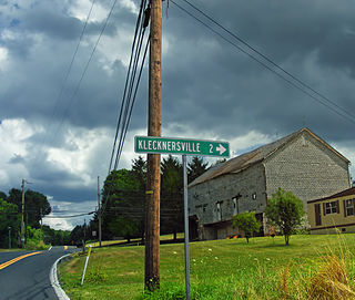
Pennsylvania Route 987 is a state highway in the Lehigh Valley region of the U.S. state of Pennsylvania. It runs 10.3 mi (16.6 km) from U.S. Route 22 near the Lehigh Valley International Airport north of Allentown north to PA 946 in Klecknersville.

<span class="mw-page-title-main">Egypt, Pennsylvania</span> Census-designated place in Pennsylvania, United States

Egypt is an unincorporated community and census-designated place (CDP) in Whitehall Township in Lehigh County, Pennsylvania, United States. The population of Egypt was 2,588 as of the 2020 census.

References

  1. "ArcGIS REST Services Directory". United States Census Bureau. Retrieved October 12, 2022.
  2. 1 2 "Census Population API". United States Census Bureau. Retrieved October 12, 2022.
  3. 1 2 3 4 5 6 7 8 9 Kearns, John (August 2, 2013). "Bath Borough Web Page" . Retrieved November 2, 2013.
  4. "Welcome". Native-Land.ca. Retrieved April 7, 2023.
  5. 1 2 "Lehigh Valley news, Easton news, Bethlehem news, Allentown news, Phillipsburg news and Lehigh Valley sports & weather" . Retrieved November 2, 2013.
  6. "Indian Outbreak of 1763". USGenWeb Archives. Retrieved May 24, 2023.
  7. "US Gazetteer files: 2010, 2000, and 1990". United States Census Bureau. February 12, 2011. Retrieved April 23, 2011.
  8. "Census of Population and Housing". U.S. Census Bureau. Retrieved December 11, 2013.
  9. 1 2 "U.S. Census website". United States Census Bureau . Retrieved January 31, 2008.
  10. "Incorporated Places and Minor Civil Divisions Datasets: Subcounty Resident Population Estimates: April 1, 2010 to July 1, 2012". Population Estimates. U.S. Census Bureau. Archived from the original on June 11, 2013. Retrieved December 11, 2013.
  11. "Explore Census Data". data.census.gov. Retrieved April 7, 2023.
  12. "Explore Census Data". data.census.gov. Retrieved April 7, 2023.
  13. "Explore Census Data". data.census.gov. Retrieved April 7, 2023.
  14. 1 2 "Explore Census Data". data.census.gov. Retrieved April 7, 2023.
  15. "Explore Census Data". data.census.gov. Retrieved April 7, 2023.
  16. "Monocacy Creek Watershed Association". LV Watershed Coalition. September 22, 2020. Retrieved October 18, 2022.
  17. Kearns, John. "Bath Farmers Market" . Retrieved November 2, 2013.
  18. ""275 YEARS OF HISTORY"". The Bath Museum. Archived from the original on August 18, 2013. Retrieved March 20, 2013.
  19. "National Register Information System". National Register of Historic Places . National Park Service. July 9, 2010.
  20. "Steckel House B&B and Antiques". 2005. Retrieved November 2, 2013.
  21. "Sacred Heart Parish | Catholic Church Bath, PA". Sacred Heart Church.
  22. "Bath Borough map" (PDF). PennDOT. Retrieved March 16, 2023.
  23. "Taking a ride on N&B Railroad | Lehigh Valley Press".