Belfast, Pennsylvania

Last updated

Belfast
CDP
Belfast, PA, Nov. 2022.jpg
Sullivan Trail in Belfast in November 2022
USA Pennsylvania location map.svg
Red pog.svg
Belfast
Location of Belfast in Pennsylvania
Usa edcp location map.svg
Red pog.svg
Belfast
Belfast (the United States)
Coordinates: 40°47′0″N75°16′35″W / 40.78333°N 75.27639°W / 40.78333; -75.27639
Country Flag of the United States.svg  United States
State Flag of Pennsylvania.svg  Pennsylvania
County Northampton
Area
  CDP3 km2 (1.1 sq mi)
  Land3 km2 (1.1 sq mi)
  Water0 km2 (0.0 sq mi)
Elevation
160 m (525 ft)
Population
 (2010)
  CDP1,257
  Density440/km2 (1,100/sq mi)
   Metro
865,310 (US: 68th)
Time zone UTC-5 (EST)
  Summer (DST) UTC-4 (EDT)
ZIP Code
18064
Area code(s) 610

Belfast is a census-designated place (CDP) in Plainfield Township in Northampton County, Pennsylvania, United States. It is part of the Lehigh Valley metropolitan area, which had a population of 861,899 and was the 68th-most populous metropolitan area in the U.S. as of the 2020 census. As of the 2010 census, the village's population was 1,257.

Contents

Located in one of the first settled areas in the township, the village is believed to have been named for the city of Belfast in Northern Ireland. Its settlers, who were predominantly German and Welsh, arrived in the area in the late 18th century. The village was originally known as Belleville or Bellville because of its scenic view. The name Belfast came into use sometime after the Civil War. [1]

Geography

According to the U.S. Census Bureau, Belfast has a total area of 1.1 square miles (2.8 km2), all land.

Demographics

As of the 2000 census, [2] there were 1,301 people, 505 households, and 382 families residing in the CDP. The population density was 1,181.0 inhabitants per square mile (456.0/km2). There were 517 housing units at an average density of 469.3 per square mile (181.2/km2). The racial makeup of the CDP was 98.00% White, 0.46% African American, 0.08% Native American, 0.54% Asian, 0.31% from other races, and 0.61% from two or more races. Hispanic or Latino of any race were 0.92% of the population.

There were 505 households, out of which 29.3% had children under the age of 18 living with them, 65.9% were married couples living together, 6.9% had a female householder with no husband present, and 24.2% were non-families. 18.4% of all households were made up of individuals, and 7.9% had someone living alone who was 65 years of age or older. The average household size was 2.58 and the average family size was 2.93.

In Belfast, the population was spread out, with 22.4% under the age of 18, 5.9% from 18 to 24, 27.5% from 25 to 44, 28.3% from 45 to 64, and 15.9% who were 65 years of age or older. The median age was 42 years. For every 100 females, there were 93.9 males. For every 100 females age 18 and over, there were 92.7 males. The median income for a household in the CDP was $43,784, and the median income for a family was $56,894. Males had a median income of $37,000 versus $23,362 for females. The per capita income for the CDP was $19,155. About 3.4% of families and 6.6% of the population were below the poverty line, including 6.8% of those under age 18 and 9.6% of those age 65 or over.

Education

The community is served by the Pen Argyl Area School District. Students in grades nine through 12 attend Pen Argyl Area High School in Pen Argyl.

Related Research Articles

Coyne Center is a census-designated place (CDP) in Rock Island County, Illinois, United States. The population was 827 at the 2010 census.

<span class="mw-page-title-main">Northampton, Suffolk County, New York</span> Hamlet and census-designated place in New York, United States

Northampton is a hamlet and census-designated place (CDP) in Suffolk County, New York, United States on Long Island. The CDP population was 570 at the 2010 census.

<span class="mw-page-title-main">Aspers, Pennsylvania</span> Census-designated place in Pennsylvania, United States

Aspers is a census-designated place in Menallen Township, Adams County, Pennsylvania, United States. As of the 2020 census, it had a population of 486. At the 2000 census it was listed as the Bendersville Station-Aspers CDP.

<span class="mw-page-title-main">West Hills, Pennsylvania</span> Census-designated place in Pennsylvania, United States

West Hills is a census-designated place (CDP) in Armstrong County, Pennsylvania, United States. The population was 1,228 at the 2020 census.

<span class="mw-page-title-main">Churchville, Pennsylvania</span> Census-designated place in Pennsylvania, United States

Churchville is a census-designated place (CDP) in Northampton Township, Bucks County, Pennsylvania, United States. The population was 5,348 at the 2020 census.

<span class="mw-page-title-main">Richboro, Pennsylvania</span> Census-designated place in Pennsylvania, United States

Richboro is a census-designated place (CDP) in Northampton Township, Bucks County, Pennsylvania, United States. The population was 6,378 during the 2020 census.

Rouzerville is an unincorporated community and census-designated place (CDP) in Franklin County, Pennsylvania, United States. The population was 903 at the 2020 census.

<span class="mw-page-title-main">Belfast Township, Fulton County, Pennsylvania</span> Township in Pennsylvania, United States

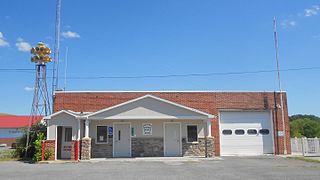
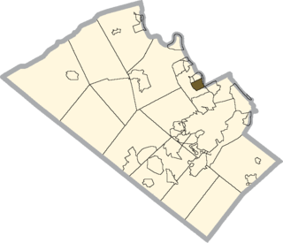
Belfast Township is a township in Fulton County in the U.S. state of Pennsylvania. The population was 1,358 at the 2020 census.

Jacksonville is a census-designated place (CDP) in Indiana County, Pennsylvania, United States. The population was 637 at the 2010 census. It was formerly an independent borough, until January 1, 1993 when it was returned to Black Lick Township, Pennsylvania.

<span class="mw-page-title-main">Hokendauqua, Pennsylvania</span> Census-designated place in Pennsylvania, United States

Hokendauqua is an unincorporated community and census-designated place (CDP) in Whitehall Township in Lehigh County, Pennsylvania, United States. The population of Hokendauqua was 3,340 as of the 2020 census. Hokendauqua is a suburb of Allentown, Pennsylvania in the Lehigh Valley metropolitan area, which had a population of 861,899 and was the 68th-most populous metropolitan area in the U.S. as of the 2020 census.

<span class="mw-page-title-main">Mountain Top, Pennsylvania</span> Census-designated place in Pennsylvania, United States

Mountain Top is an unincorporated area and census-designated place (CDP) in Luzerne County, Pennsylvania, United States. As of the 2010 census, its population was 10,982.

<span class="mw-page-title-main">Bangor, Pennsylvania</span> Borough in Pennsylvania, United States

Bangor, or West Bangor, to differentiate it from its immediate neighbor East Bangor, is a borough located in Northampton County, Pennsylvania, United States. It is located 32 miles (51 km) north of Allentown. It had a population of 5,187 as of the 2020 census.

Eastlawn Gardens is a census-designated place (CDP) in Upper Nazareth Township in Northampton County, Pennsylvania, United States. The population of Eastlawn Gardens was 3,307 at the 2010 census. Eastlawn Gardens is part of the Lehigh Valley metropolitan area, which had a population of 861,899 and was the 68th-most populous metropolitan area in the U.S. as of the 2020 census.

Middletown is a census-designated place (CDP) in Bethlehem Township in Northampton County, Pennsylvania, United States. The population of Middletown was 7,441 at the 2010 census. Middletown is part of the Lehigh Valley, which had a population of 861,899 and was the 68th-most populous metropolitan area in the U.S. as of the 2020 census.

<span class="mw-page-title-main">Old Orchard, Pennsylvania</span> Place in Pennsylvania, United States

Old Orchard is a census-designated place (CDP) in Palmer Township in Northampton County, Pennsylvania, United States. As of the 2010 census, Old Orchard had a total population of 2,434. Old Orchard is part of the Lehigh Valley, which had a population of 861,899 and was the 68th-most populous metropolitan area in the U.S. as of the 2020 census.

<span class="mw-page-title-main">Pen Argyl, Pennsylvania</span> Borough in Pennsylvania, United States

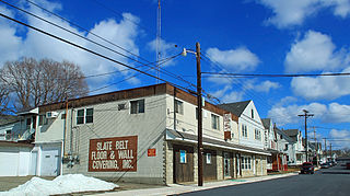
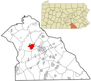
Pen Argyl is a borough in Northampton County, Pennsylvania. The borough's population was 3,510 as of the 2020 census.

<span class="mw-page-title-main">Plainfield Township, Pennsylvania</span> Place in Pennsylvania, United States

Plainfield Township is a township in Northampton County, Pennsylvania, United States. The population of Plainfield Township was 6,138 at the 2010 census. The township is part of the Lehigh Valley metropolitan area, which had a population of 861,899 and was the 68th-most populous metropolitan area in the U.S. as of the 2020 census.

<span class="mw-page-title-main">Wind Gap, Pennsylvania</span> Borough in Pennsylvania, United States

Wind Gap is a borough in Northampton County, Pennsylvania. The population of Wind Gap was 2,820 at the 2020 census. Wind Gap is part of the Lehigh Valley metropolitan area, which had a population of 861,899 and was the 68th-most populous metropolitan area in the U.S. as of the 2020 census.

Forestville is a census-designated place (CDP) in Schuylkill County, Pennsylvania, United States. The population was 431 at the 2000 census.

<span class="mw-page-title-main">Weigelstown, Pennsylvania</span> CDP in Pennsylvania, United States

Weigelstown is a census-designated place (CDP) in York County, Pennsylvania, United States. The population was 15,136 at the 2020 census.

References

  1. Wright, James; Wright, Wright (1988). Place Names of Northampton County, Pennsylvania. Nazareth, Pennsylvania: J&L Wright. pp. 12–13.
  2. "U.S. Census website". United States Census Bureau . Retrieved January 31, 2008.