Glendon, Pennsylvania

Last updated

Borough of Glendon
Glendon Borough Hall, Pennsylvania 01.JPG
Glendon Borough Hall in July 2015
Northampton County Pennsylvania Incorporated and Unincorporated areas Glendon Highlighted.svg
Location of Glendon in Northampton County, Pennsylvania (left) and of Northampton County in Pennsylvania (right)
USA Pennsylvania location map.svg
Red pog.svg
Glendon
Location of Glendon in Pennsylvania
Usa edcp location map.svg
Red pog.svg
Glendon
Glendon (the United States)
Coordinates: 40°39′44″N75°14′09″W / 40.66222°N 75.23583°W / 40.66222; -75.23583
Country Flag of the United States.svg  United States
State Flag of Pennsylvania.svg  Pennsylvania
County Northampton
Government
  MayorMindy McAllister
Area
[1]
  City0.62 sq mi (1.60 km2)
  Land0.61 sq mi (1.59 km2)
  Water0.00 sq mi (0.00 km2)
Elevation
230 ft (70 m)
Population
 (2020) [2]
  City373
  Density606.50/sq mi (234.09/km2)
   Metro
865,310 (US: 68th)
Time zone UTC-5 (EST)
  Summer (DST) UTC-4 (EDT)
ZIP Code
18042
Area codes 610 and 484
FIPS code 42-29568
Primary airport Lehigh Valley International Airport
Major hospital Lehigh Valley Hospital–Cedar Crest
School district Wilson Area
Website www.glendonboro.com

Glendon is a borough in Northampton County, Pennsylvania. The population of Glendon was 373 at the 2020 census. Glendon is part of the Lehigh Valley metropolitan area, which had a population of 861,899 and was thus the 68th-most populous metropolitan area in the U.S. as of the 2020 census.

Contents

Geography

Glendon is located at 40°39′44″N75°14′9″W / 40.66222°N 75.23583°W / 40.66222; -75.23583 (40.662152, -75.235758). [3] According to the U.S. Census Bureau, the borough has a total area of 0.6 square miles (1.6 km2), all land.

Transportation

I-78 West in Glendon 2022-08-16 08 15 31 View west along Interstate 78 just west of Exit 75 in Glendon, Northampton County, Pennsylvania.jpg
I-78 West in Glendon

As of 2007, there were 4.33 miles (6.97 km) of public roads in Glendon, of which 1.07 miles (1.72 km) were maintained by the Pennsylvania Department of Transportation (PennDOT) and 3.26 miles (5.25 km) were maintained by the borough. [4]

Interstate 78 passes through Glendon, following a southwest-northeast alignment through the length of the borough. However, the nearest exit is in neighboring Williams Township. Main thoroughfares in the borough include Island Park Road, Main Street, and 25th Street.

Demographics

Historical population
CensusPop.Note
1870 707
1880 98238.9%
1890 907−7.6%
1900 704−22.4%
1910 82316.9%
1920 715−13.1%
1930 615−14.0%
1940 552−10.2%
1950 6018.9%
1960 555−7.7%
1970 63714.8%
1980 354−44.4%
1990 39110.5%
2000 367−6.1%
2010 44019.9%
2020 373−15.2%
Sources: [5] [6] [7] [2]

As of the 2000 census, [6] there were 367 people, 139 households, and 98 families residing in the borough. The population density was 573.7 inhabitants per square mile (221.5/km2). There were 150 housing units at an average density of 234.5 per square mile (90.5/km2). The racial makeup of the borough was 95.64% White, 0.82% African American, 1.36% Asian, 0.27% from other races, and 1.91% from two or more races. Hispanic or Latino of any race were 2.18% of the population.

There were 139 households, out of which 33.1% had children under the age of 18 living with them, 58.3% were married couples living together, 7.9% had a female householder with no husband present, and 28.8% were non-families. 23.0% of all households were made up of individuals, and 16.5% had someone living alone who was 65 years of age or older. The average household size was 2.64 and the average family size was 3.15.

In the borough, the population was spread out, with 28.9% under the age of 18, 4.4% from 18 to 24, 30.2% from 25 to 44, 23.4% from 45 to 64, and 13.1% who were 65 years of age or older. The median age was 36 years. For every 100 females there were 109.7 males. For every 100 females age 18 and over, there were 107.1 males.

The median income for a household in the borough was $42,969, and the median income for a family was $45,417. Males had a median income of $37,813 versus $33,375 for females. The per capita income for the borough was $17,593. About 12.9% of families and 15.4% of the population were below the poverty line, including 28.4% of those under age 18 and 9.1% of those age 65 or over.

Public education

The borough is served by the Wilson Area School District. Students in grades nine through 12 attend Wilson Area High School in Easton.

Related Research Articles

<span class="mw-page-title-main">Manorville, Pennsylvania</span> Borough in Pennsylvania, United States

Manorville is a borough in Armstrong County, Pennsylvania, United States. The population was 382 at the 2020 census.

<span class="mw-page-title-main">Bechtelsville, Pennsylvania</span> Borough in Pennsylvania, United States

Bechtelsville is a borough in Berks County, Pennsylvania, United States. The population was 942 at the 2010 census.

<span class="mw-page-title-main">Lenhartsville, Pennsylvania</span> Borough in Pennsylvania, United States

Lenhartsville is a borough in Berks County, Pennsylvania, United States. The population was 165 at the 2010 census.

<span class="mw-page-title-main">Lyons, Pennsylvania</span> Borough in Pennsylvania, United States

Lyons is a borough that is located in Berks County, Pennsylvania, United States. The population was 478 at the time of the 2010 census.

<span class="mw-page-title-main">Mohnton, Pennsylvania</span> Borough in Pennsylvania, United States

Mohnton is a borough in Berks County, Pennsylvania, United States. It had a population of 3,043 in the 2010 census.

<span class="mw-page-title-main">Topton, Pennsylvania</span> Borough in Pennsylvania, United States

Topton is a borough in Berks County, Pennsylvania, United States. The population was 2,069 at the 2010 census.

<span class="mw-page-title-main">Bowmanstown, Pennsylvania</span> Borough in Pennsylvania, United States

Bowmanstown is a borough in Carbon County, Pennsylvania. It is part of Northeastern Pennsylvania. The population was 937 at the 2010 census.

<span class="mw-page-title-main">Modena, Pennsylvania</span> Borough in Pennsylvania, United States

Modena is a borough in Chester County, Pennsylvania, United States. The population was 544 at the 2020 census. It was originally called Modeville, after the local Mode family.

<span class="mw-page-title-main">Spring City, Pennsylvania</span> Borough in Pennsylvania, United States

Spring City is a borough in Chester County, Pennsylvania, United States. The population was 3,494 at the 2020 census. Spring City is a member of the Spring-Ford Area School District.

<span class="mw-page-title-main">Coplay, Pennsylvania</span> Borough in Pennsylvania, United States

Coplay is a borough in Lehigh County, Pennsylvania. Coplay's population was 3,348 at the 2020 census. It is located six miles (10 km) northwest of Allentown. The borough is part of the Lehigh Valley metropolitan area, which had a population of 861,899 and was the 68th-most populous metropolitan area in the U.S. as of the 2020 census.

<span class="mw-page-title-main">Lewis Run, Pennsylvania</span> Borough in Pennsylvania, United States

Lewis Run is a borough in McKean County, Pennsylvania, United States. The population was 578 at the 2020 census.

<span class="mw-page-title-main">Green Lane, Pennsylvania</span> Borough in Pennsylvania, United States

Green Lane is a borough in Montgomery County, Pennsylvania. The population was 490 at the 2020 census. It is part of the Upper Perkiomen School District and Boyertown Area School District.

<span class="mw-page-title-main">Pennsburg, Pennsylvania</span> Borough in Pennsylvania, United States

Pennsburg is a borough in Montgomery County, Pennsylvania. Its population was 3,889 at the 2020 census. It is part of the Upper Perkiomen School District. It is also part of the strip of small towns that run together along Route 29: Red Hill, Pennsburg, and East Greenville. The towns are collectively referred to as Upper Perk.

<span class="mw-page-title-main">Royersford, Pennsylvania</span> Borough in Pennsylvania, United States

Royersford is a borough in Montgomery County, Pennsylvania, United States, 32 miles (51 km) northwest of Philadelphia, on the Schuylkill River.

<span class="mw-page-title-main">Chapman, Pennsylvania</span> Borough in Pennsylvania, United States

Chapman is a borough in Northampton County, Pennsylvania. The population of Chapman was 223 as of the 2020 census. Chapman is part of the Lehigh Valley metropolitan area, which had a population of 861,899 and was the 68th-most populous metropolitan area in the U.S. as of the 2020 census.

<span class="mw-page-title-main">East Bangor, Pennsylvania</span> Place in Pennsylvania, United States

East Bangor is a borough in Northampton County, Pennsylvania, US, with population 1,124 at the 2020 census. It is in the Lehigh Valley metropolitan region, which had a population of 861,899 and was the 68th-most populous metropolitan area in the U.S. as of the 2020 census.

<span class="mw-page-title-main">Tatamy, Pennsylvania</span> Place in Pennsylvania, United States

Tatamy is a borough in Northampton County, Pennsylvania. The borough's population was 1,203 as of the 2020 census. Tatamy is part of the Lehigh Valley metropolitan area, which had a population of 861,899 and was the 68th most populous metropolitan area in the U.S. as of the 2020 census.

<span class="mw-page-title-main">Wind Gap, Pennsylvania</span> Borough in Pennsylvania, United States

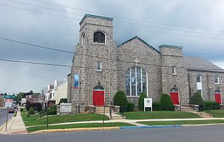
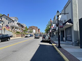
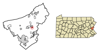
Wind Gap is a borough in Northampton County, Pennsylvania. The population of Wind Gap was 2,820 at the 2020 census. Wind Gap is part of the Lehigh Valley metropolitan area, which had a population of 861,899 and was the 68th-most populous metropolitan area in the U.S. as of the 2020 census.

<span class="mw-page-title-main">Union Dale, Pennsylvania</span> Borough in Pennsylvania, United States

Union Dale is a borough in Susquehanna County, Pennsylvania, United States. The borough was incorporated in 1885. Union Dale's population was 267 at the 2010 census.

<span class="mw-page-title-main">Sutersville, Pennsylvania</span> Borough in Pennsylvania, United States

Sutersville is a borough in Westmoreland County, Pennsylvania, United States. The population was 605 at the 2010 census.

References

  1. "ArcGIS REST Services Directory". United States Census Bureau. Retrieved October 12, 2022.
  2. 1 2 "Census Population API". United States Census Bureau. Retrieved October 12, 2022.
  3. "US Gazetteer files: 2010, 2000, and 1990". United States Census Bureau. February 12, 2011. Retrieved April 23, 2011.
  4. "Glendon Borough map" (PDF). PennDOT. Retrieved March 16, 2023.
  5. "Census of Population and Housing". U.S. Census Bureau. Retrieved December 11, 2013.
  6. 1 2 "U.S. Census website". United States Census Bureau . Retrieved January 31, 2008.
  7. "Incorporated Places and Minor Civil Divisions Datasets: Subcounty Resident Population Estimates: April 1, 2010 to July 1, 2012". Population Estimates. U.S. Census Bureau. Archived from the original on June 11, 2013. Retrieved December 11, 2013.