Cape Henry Lighthouses

Last updated

Cape Henry Lighthouse
Fort Story lighthouses.jpg
The new and old lighthouses at Cape Henry
USA Virginia location map.svg
Red pog.svg
Usa edcp location map.svg
Red pog.svg
Location Virginia Beach, Virginia
Coordinates 36°55′32″N76°0′30″W / 36.92556°N 76.00833°W / 36.92556; -76.00833
BuiltOld Lighthouse, 1792; New lighthouse, 1881
ArchitectFederal Government
MPS Light Stations of the United States MPS
NRHP reference No. 66000910, 02001439
VLR No.134-0007, 134-0079
Significant dates
Added to NRHPOctober 15, 1966, December 2, 2002 [1]
Designated NHLApril 15, 1970 [2]
Designated VLRSeptember 9, 1969, September 10, 2003 [3]

The Cape Henry Lighthouses are a pair of lighthouses at Cape Henry, the landform marking the southern entrance to Chesapeake Bay in the U.S. state of Virginia. The location has long been important for the large amount of ocean-going shipping traffic for the harbors, its rivers, and shipping headed to ports on the bay. The original lighthouse was the first authorized by the U.S. government, dating from 1792. It was also the first federal construction project under the Constitution, for an original contract amount of $15,200 (an additional $2,500 was required to finish the lighthouse). A second lighthouse was built and completed in 1881 a short distance away after concern arose about the stability of the first. Both towers of the light station were designated a National Historic Landmark in 1970.

Contents

History

The first work of the new U.S. Federal government, the first Cape Henry lighthouse was built of Aquia and Rappahannock sandstone by John McComb Jr. and was completed in October, 1792. McComb was one of the architects involved in the construction of New York City Hall and would go on to design other lighthouses. The lighthouse's design was based on the 1767 Cape Henlopen Light. [4] The lighthouse was damaged by Confederate forces during the American Civil War, but was repaired by Union forces in 1863, who depended on the light for navigation. [5] In the 1870s, concerns about the condition and safety of the old Lighthouse at Cape Henry following a lightning strike that caused large cracks in the structure led to the construction of a new, taller, lighthouse at Cape Henry (pictured to the right) in 1881, which stands 350 feet to the northeast of the original tower. [6] The old tower remained standing, used as a daymark and as a basis for triangulation. The lighthouse was fully automated in 1983 and remains in use today. [7] [8]

Description

In 1798, Benjamin Latrobe visited Cape Henry Lighthouse and described it as "an octangular truncated pyramid of eight sides, rising 90 feet to the light..." [9] The Old Cape Henry Lighthouse is 26 feet in diameter at its base, and 16 feet at its top. [8] It was built with Aquia Creek sandstone from the same source as the White House. [10]

The new lighthouse, 157 feet (48 m) tall, was built of cast iron and wrought iron, with a more powerful first-order Fresnel lens. [4] It is the only lighthouse on the Virginia coast that is still equipped with a first-order Fresnel lens.

Preservation

The older lighthouse was acquired in 1930 by Preservation Virginia (formerly known as the Association for the Preservation of Virginia Antiquities). A brick lining and an iron stairway have been added to the interior. The lighthouse is open to the public and a fine view can be enjoyed from its observation platform. It was designated a National Historic Landmark on January 29, 1964. In 2002 the American Society of Civil Engineers designated the lighthouse a National Historic Civil Engineering Landmark. [5] [8]

The lighthouses are located in the city of Virginia Beach within the boundaries of Joint Expeditionary Base East, a Navy base. The Cape Henry Memorial is adjacent to the lighthouses. [5]

See also

Related Research Articles

<span class="mw-page-title-main">Cape May Lighthouse</span> Lighthouse

The Cape May Lighthouse is a lighthouse located in the U.S. state of New Jersey at the tip of Cape May, in Lower Township's Cape May Point State Park. It was built in 1859 under the supervision of U.S. Army engineer William F. Raynolds, was automated in 1946, and continues operation to this day.

<span class="mw-page-title-main">Jones Point Light</span> Lighthouse in Virginia, United States

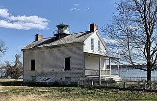
The Jones Point Light is a small river lighthouse located on the Potomac River in Alexandria, Virginia. It was built in 1855.

<span class="mw-page-title-main">Navesink Twin Lights</span> Lighthouse

The Navesink Twin Lights is a non-operational lighthouse and museum located in Highlands, Monmouth County, New Jersey, United States, overlooking Sandy Hook Bay, the entrance to New York Harbor, and the Atlantic Ocean. The Twin Lights, as the name implies, are a pair of beacons located 246 feet (75 m) above sea level on the headlands of the Navesink Highlands.

<span class="mw-page-title-main">Bald Head Light</span> Lighthouse in North Carolina, US

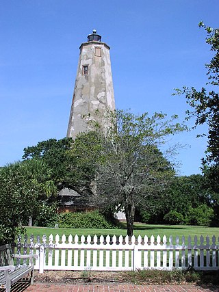
Bald Head Lighthouse, known as Old Baldy, is the oldest lighthouse still standing in North Carolina. It is the second of three lighthouses that have been built on Bald Head Island since the 18th century to help guide ships past the dangerous shoals at the mouth of the Cape Fear river.

<span class="mw-page-title-main">Block Island Southeast Light</span> Lighthouse in Rhode Island, United States

Block Island Southeast Light is a lighthouse located on Mohegan Bluffs at the southeastern corner of Block Island, Rhode Island. It was designated a U.S. National Historic Landmark in 1997 as one of the most architecturally sophisticated lighthouses built in the United States in the 19th century.

<span class="mw-page-title-main">Assateague Light</span> Lighthouse in Virginia, United States

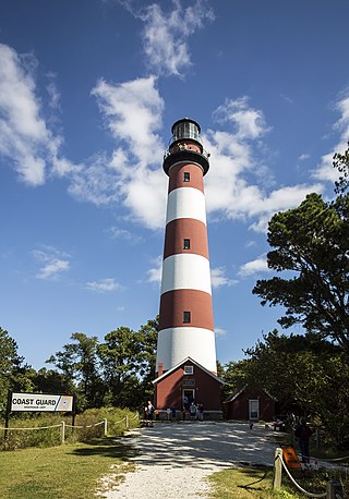
Assateague Light is the 142-foot-tall (43 m) lighthouse located on the southern end of Assateague Island off the coast of the Virginia Eastern Shore, United States. The lighthouse is located within the Chincoteague National Wildlife Refuge and can be accessed by road from Chincoteague Island over the Assateague Channel. It is owned by the U.S. Fish and Wildlife Service and operated by the U.S. Coast Guard and is still used as an active aid in navigation. The keeper's quarters are used as seasonal housing for refuge temporary employees, volunteers, and interns. Constructed in 1867 to replace a shorter lighthouse 45-foot-tall (14 m) built in 1833, the lighthouse is conical in shape and is painted in alternating bands of red and white.

<span class="mw-page-title-main">Thomas Point Shoal Light</span> Lighthouse in Maryland, United States

The Thomas Point Shoal Light, also known as Thomas Point Shoal Light Station, is a historic lighthouse in the Chesapeake Bay on the east coast of the United States, and the most recognized lighthouse in Maryland. It is the only screw-pile lighthouse in the bay which stands at its original site. The current structure is a 1½ story hexagonal wooden cottage, equipped with a foghorn as well as the light.

<span class="mw-page-title-main">Ponce de Leon Inlet Light</span> Lighthouse in Florida, US

The Ponce de Leon Inlet Light is a lighthouse and museum located at Ponce de León Inlet in Central Florida. At 175 feet (53 m) in height, it is the tallest lighthouse in the state and one of the tallest in the United States. It is located between St. Augustine Light and Cape Canaveral Light. Restored by the Ponce de Leon Inlet Lighthouse Preservation Association, the lighthouse became a National Historic Landmark in 1998.

<span class="mw-page-title-main">Sharps Island Light</span> Lighthouse in Maryland, United States

The Sharps Island Light is the third lighthouse to stand nearly 3 miles (5 km) south-southwest from the southern end of Tilghman Island in Maryland's Chesapeake Bay. The structure is best known today for evoking the Leaning Tower of Pisa, a condition caused by an ice floe in 1977.

<span class="mw-page-title-main">Cove Point Light</span> Lighthouse in Maryland, United States

The Cove Point Light is a lighthouse located on the west side of Chesapeake Bay in Calvert County, Maryland.

<span class="mw-page-title-main">Hooper Island Light</span> Lighthouse in Maryland, United States

The Hooper Island Light is a lighthouse in the Chesapeake Bay, west of Middle Hooper Island in Maryland.

<span class="mw-page-title-main">New Point Comfort Light</span> Lighthouse in Virginia, United States

New Point Comfort Light is a lighthouse in the Virginia portion of the Chesapeake Bay, United States, off the tip of the Middle Peninsula. Finished in 1804, it is the third-oldest surviving light in the bay, and the tenth-oldest in the United States.

<span class="mw-page-title-main">Old Point Comfort Light</span> Lighthouse in Virginia, United States

Old Point Comfort Light is a lighthouse located on the grounds of Fort Monroe in the Virginia portion of the Chesapeake Bay. It is the second oldest light in the bay and the oldest still in use. The lighthouse is owned and maintained by the U.S. Coast Guard and is listed on the National Register of Historic Places.

<span class="mw-page-title-main">Cape Charles Lighthouse</span> Lighthouse in Virginia, United States

Cape Charles Lighthouse is an octagonal cast iron skeleton tower lighthouse at the mouth of the Chesapeake Bay on Smith Island which was officially removed from service in 2019. It is the tallest lighthouse in Virginia and the second tallest in the United States. This particular tower is the third lighthouse at this location. The first lighthouse at Cape Charles was a 55-foot (17 m) masonry tower completed in 1828. It was quickly deemed inadequate for its important seacoast location due to its low height and poor visibility at sea. It was soon threatened by erosion so in 1864 it was replaced by a 150-foot (46 m) masonry tower built further inland. Located a little more than a mile southwest of the old tower and 600 feet from the shoreline, the impressive 150-foot-tall conical brick tower was similar in appearance to the 1857 Cape May Lighthouse, painted white and topped with a dark brown lantern room. In 1892, a twenty-five-foot red band was painted around the white tower's midsection, about sixty feet up from the base, to make it more visible during the day. By the 1890s, it too was threatened by beach erosion which jetties built to protect it failed to halt, and with the lighthouse now only 300 feet from the ocean and the shoreline eroding at a rate of 37 feet per year it was decided that a third lighthouse needed to be built three quarters of a mile inland.

<span class="mw-page-title-main">Thimble Shoal Light</span> Lighthouse in Virginia, United States

Thimble Shoal Light is a sparkplug lighthouse in the Virginia portion of Chesapeake Bay, north of the Hampton Roads channel. The third light at this location, it is listed on the National Register of Historic Places.

<span class="mw-page-title-main">Ashtabula Harbor Light</span> Lighthouse in Ohio, US

Ashtabula Harbor Light is a lighthouse in Ashtabula, Ohio. It was listed in the National Register on August 8, 1983.

<span class="mw-page-title-main">Staten Island Light</span> Lighthouse

The Staten Island Range Light, also known as the Ambrose Channel Range Light, is the rear range light companion to the West Bank Lighthouse. Built in 1912, the 90-foot tower sits more than five miles northwest of the West Bank Lighthouse, on Staten Island’s Richmond Hill, 141 feet above sea level. It shows a fixed white light that can be seen for 18 miles, by all vessels bound to New York and New Jersey Ports coming in from the Atlantic Ocean.

<span class="mw-page-title-main">Brandywine Shoal Light</span> Lighthouse

The Brandywine Shoal Light is a lighthouse on the north side of the ship channel in Delaware Bay on the east coast of the United States, west of Cape May, Cape May County, New Jersey, United States. It was the site of the first screw-pile lighthouse in the United States.

<span class="mw-page-title-main">Pigeon Point Lighthouse</span> Historic lighthouse in California, United States

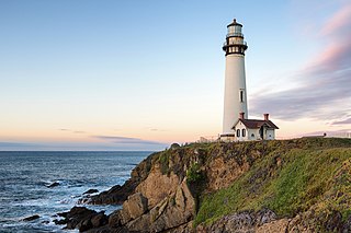
Pigeon Point Light Station or Pigeon Point Lighthouse is a lighthouse built in 1871 to guide ships on the Pacific coast of California. It is the tallest lighthouse on the West Coast of the United States. It is still an active Coast Guard aid to navigation. Pigeon Point Light Station is located on the coastal highway, 5 miles (8 km) south of Pescadero, California, between Santa Cruz and San Francisco. The 115-foot (35 m), white masonry tower, resembles the typical New England structure.

References

  1. "National Register Information System". National Register of Historic Places . National Park Service. January 23, 2007.
  2. "Cape Henry Lighthouse". National Historic Landmark summary listing. National Park Service. Archived from the original on December 26, 2007. Retrieved June 26, 2008.
  3. "Virginia Landmarks Register". Virginia Department of Historic Resources. Archived from the original on September 21, 2013. Retrieved March 19, 2013.
  4. 1 2 Wilson, Richard Guy, ed. (2002). The Buildings of Virginia:Tidewater and Piedmont. Oxford University Press. p. 455. ISBN   0-19-515206-9.
  5. 1 2 3 "Cape Henry Lighthouse". Preservation Virginia. Archived from the original on September 27, 2011. Retrieved October 21, 2011.
  6. "Old Cape Henry Lighthouse, Virginia at Lighthousefriends.com". Archived from the original on May 7, 2006. Retrieved May 13, 2006.
  7. Catherine E. Dean, "The Old Cape Henry Lighthouse", 2006, APVA Preservation Virginia, ISBN   1-891468-48-0
  8. 1 2 3 Sheely, Horace J. (1963). "Old Cape Henry Lighthouse National Historic Landmark Study Designated January 29, 1964". Maritime Landmarks: Light Stations. National Park Service. Retrieved October 21, 2011.
  9. Lighthouse Friends Old Cape Henry description Archived May 7, 2006, at the Wayback Machine
  10. Preserving Virginia 1889-1989: Centennial Pictorial. Virginia: The Art Band. 1989. p. 10.