Cynthiana, Kentucky

Last updated

Cynthiana, Kentucky
Cynthiana Kentucky.png
City of Cynthiana at Sunset
Harrison County Kentucky Incorporated and Unincorporated areas Cynthiana Highlighted 2119432.svg
Location of Cynthiana in Harrison County, Kentucky.
Coordinates: 38°23′10″N84°17′58″W / 38.38611°N 84.29944°W / 38.38611; -84.29944
Country United States
State Kentucky
County Harrison
Government
   Mayor James Smith [ citation needed ]
Area
[1]
  Total4.44 sq mi (11.50 km2)
  Land4.39 sq mi (11.37 km2)
  Water0.05 sq mi (0.13 km2)
Elevation
[2]
702 ft (214 m)
Population
 (2020)
  Total6,333
  Estimate 
(2022) [3]
6,441
  Density1,442.60/sq mi (556.99/km2)
Time zone UTC−5 (EST)
  Summer (DST) UTC−4 (EDT)
ZIP Code
41031
Area code 859
FIPS code 21-19432
GNIS feature ID2404172 [2]
Website www.cynthianaky.com
Harrison County Courthouse in Cynthiana Harrison county kentucky courthouse.jpg
Harrison County Courthouse in Cynthiana

Cynthiana is a home rule-class city [4] in Harrison County, Kentucky, in the United States. The population was 6,402 at the 2010 census. [5] It is the seat of its county. [6]

Contents

History

The settlement developed on both sides of the South Fork of the Licking River. It was named after Cynthia and Anna Harrison, [7] daughters of Robert Harrison, who had donated land to establish the town center. [8] Harrison County, on the other hand, was named after Colonel Benjamin Harrison, an early settler in the area who had served as sheriff of Bourbon County. [9]

Two Civil War battles were fought in Cynthiana. The first on July 17, 1862, was part of a cavalry raid into Kentucky (which stayed in the Union) by Confederate General John Hunt Morgan; the second, on June 11 and 12, 1864, resulted in Union defeat of Confederate forces during Morgan's last raid into the state. [10] [11]

On January 23, 1877, an LL chondrite meteorite fell in Cynthiana. [12]

On March 2, 1997, the South Fork of the Licking River flooded, causing extensive damage in Cynthiana and neighboring communities.

In early March 2020, near the beginning of the COVID-19 pandemic in the United States, Cynthiana was reported to have the first case of the disease diagnosed in Kentucky. Four more cases soon followed, and by March 12, most businesses, schools and churches closed in an effort to prevent further spread. [13]

Geography

Cynthiana is located in southern Harrison County. U.S. Routes 27 and 62 pass through the city, passing west of the downtown area. US 27 leads north 56 miles (90 km) to Cincinnati and south 14 miles (23 km) to Paris, while US 62 leads northeast 46 miles (74 km) to Maysville and southwest 21 miles (34 km) to Georgetown. Lexington is 31 miles (50 km) to the southwest via US 27 or 29 miles (47 km) via Kentucky Route 353.

According to the United States Census Bureau, the city has a total area of 4.1 square miles (10.5 km2), of which 4.0 square miles (10.4 km2) are land and 0.04 square miles (0.1 km2), or 1.09%, are water. [5] The South Fork of the Licking River, a tributary of the Ohio River, flows south to north through the city, passing west of the downtown area.

Climate

The climate in this area is characterized by hot, humid summers and generally mild to cool winters. According to the Köppen Climate Classification system, Cynthiana has a humid subtropical climate, abbreviated "Cfa" on climate maps. [14]

Climate data for Cynthiana, Kentucky (1991–2020 normals, extremes 1951–present)
MonthJanFebMarAprMayJunJulAugSepOctNovDecYear
Record high °F (°C)74
(23)
79
(26)
88
(31)
91
(33)
94
(34)
102
(39)
105
(41)
106
(41)
103
(39)
95
(35)
83
(28)
77
(25)
106
(41)
Mean maximum °F (°C)64.5
(18.1)
68.8
(20.4)
75.5
(24.2)
82.2
(27.9)
87.9
(31.1)
92.5
(33.6)
94.8
(34.9)
93.6
(34.2)
92.0
(33.3)
84.1
(28.9)
74.5
(23.6)
66.0
(18.9)
96.1
(35.6)
Mean daily maximum °F (°C)41.2
(5.1)
45.9
(7.7)
55.3
(12.9)
67.2
(19.6)
75.8
(24.3)
83.5
(28.6)
86.7
(30.4)
86.2
(30.1)
80.4
(26.9)
69.1
(20.6)
55.8
(13.2)
45.7
(7.6)
66.1
(18.9)
Daily mean °F (°C)32.0
(0.0)
35.4
(1.9)
43.7
(6.5)
54.3
(12.4)
64.1
(17.8)
72.1
(22.3)
76.0
(24.4)
74.6
(23.7)
67.9
(19.9)
56.2
(13.4)
44.3
(6.8)
36.5
(2.5)
54.8
(12.7)
Mean daily minimum °F (°C)22.7
(−5.2)
24.9
(−3.9)
32.2
(0.1)
41.4
(5.2)
52.3
(11.3)
60.6
(15.9)
65.2
(18.4)
63.0
(17.2)
55.3
(12.9)
43.3
(6.3)
32.9
(0.5)
27.4
(−2.6)
43.4
(6.3)
Mean minimum °F (°C)2.4
(−16.4)
8.5
(−13.1)
15.7
(−9.1)
26.7
(−2.9)
37.3
(2.9)
47.3
(8.5)
55.0
(12.8)
53.1
(11.7)
41.9
(5.5)
30.0
(−1.1)
19.8
(−6.8)
10.0
(−12.2)
−1.1
(−18.4)
Record low °F (°C)−34
(−37)
−23
(−31)
−8
(−22)
13
(−11)
23
(−5)
33
(1)
44
(7)
36
(2)
31
(−1)
15
(−9)
−6
(−21)
−21
(−29)
−34
(−37)
Average precipitation inches (mm)3.38
(86)
3.47
(88)
4.53
(115)
4.61
(117)
4.98
(126)
4.54
(115)
4.83
(123)
3.06
(78)
3.53
(90)
3.45
(88)
3.22
(82)
4.13
(105)
47.73
(1,212)
Average precipitation days (≥ 0.01 in)9.37.910.311.211.510.59.27.96.97.18.89.5110.1
Source: NOAA [15] [16] [17]

Transportation

U.S. Highways

Kentucky state highways

Education

Cynthiana is served by the Harrison County School District with a total of seven public schools located within the county limits:

Cynthiana has one private school:

Maysville Community and Technical College has an extended campus located in Cynthiana

Cynthiana has a public library, the Cynthiana-Harrison Public Library. [18]

Demographics

Historical population
CensusPop.Note
1800 78
1810 369373.1%
1830 975
1840 798−18.2%
1860 1,237
1870 1,77143.2%
1880 2,10118.6%
1890 3,01643.6%
1900 3,2578.0%
1910 3,60310.6%
1920 3,8577.0%
1930 4,38613.7%
1940 4,84010.4%
1950 4,8470.1%
1960 5,64116.4%
1970 6,35612.7%
1980 5,881−7.5%
1990 6,49710.5%
2000 6,258−3.7%
2010 6,4022.3%
2020 6,333−1.1%
2022 (est.)6,441 [19] 1.7%
U.S. Decennial Census [20]

As of the census [21] of 2000, there were 6,258 people, 2,692 households, and 1,639 families residing in the city. The population density was 1,873.6 inhabitants per square mile (723.4/km2). There were 2,909 housing units at an average density of 870.9 per square mile (336.3/km2). The racial makeup of the city was 92.43% White, 5.29% Black or African American, 0.16% Native American, 0.18% Asian, 0.05% Pacific Islander, 0.81% from other races, and 1.09% from two or more races. Hispanic or Latino of any race were 1.41% of the population.

There were 2,692 households, out of which 27.3% had children under the age of 18 living with them, 42.2% were married couples living together, 14.9% had a female householder with no husband present, and 39.1% were non-families. 36.0% of all households were made up of individuals, and 18.7% had someone living alone who was 65 years of age or older. The average household size was 2.24 and the average family size was 2.89.

In the city, the population was spread out, with 22.7% under the age of 18, 9.0% from 18 to 24, 26.3% from 25 to 44, 21.9% from 45 to 64, and 20.1% who were 65 years of age or older. The median age was 40 years. For every 100 females, there were 80.9 males. For every 100 females age 18 and over, there were 77.3 males.

The median income for a household in the city was $28,519, and the median income for a family was $34,691. Males had a median income of $27,704 versus $20,659 for females. The per capita income for the city was $15,227. About 13.3% of families and 16.1% of the population were below the poverty line, including 23.1% of those under age 18 and 11.7% of those age 65 or over.

Economy

3M established a factory in Cynthiana in 1969. Post-it notes were developed in 1972 by Arthur Fry and Spencer Silver. Until patents expired in the late 1990s, the 3M factory in Cynthiana was the only production site of Post-it notes worldwide. Today, it still accounts for nearly all of the world's production. [22]

Media

Newspaper

The Cynthiana Democrat, owned by Paxton Media Group, formerly by Landmark Community Newspapers. Subscription-based weekly newspaper, printed every Thursday with in-home delivery. Has been in print since 1868. Also is available at www.cynthianademocrat.com

Radio

Call signFrequencyFormatDescription / Notes
WCYN 1400 kHz Classic hits

Notable people

Related Research Articles

<span class="mw-page-title-main">Pike County, Kentucky</span> County in Kentucky, United States

Pike County is a county in the U.S. state of Kentucky. As of the 2020 Census, the population was 58,669. Its county seat is Pikeville. The county was founded in 1821. With regard to the sale of alcohol, it is classified as a moist county–– a county in which alcohol sales are prohibited, but containing a "wet" city. There are three cities in the county, Pikeville, Elkhorn City, and Coal Run Village, where package alcohol sales are legal.

<span class="mw-page-title-main">Pendleton County, Kentucky</span> County in Kentucky, United States

Pendleton County is a county located in the U.S. state of Kentucky. As of the 2020 census, the population was 14,644. Its county seat is Falmouth. The county was founded December 13, 1798. Pendleton County is included in the Cincinnati-Middletown, OH-KY-IN Metropolitan Statistical Area.

<span class="mw-page-title-main">Mason County, Kentucky</span> County in Kentucky, United States

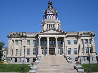
Mason County is a county located in the U.S. state of Kentucky. As of the 2020 census, the population was 17,120. Its county seat is Maysville. The county was created from Bourbon County, Virginia in 1788 and named for George Mason, a Virginia delegate to the U.S. Constitutional Convention known as the "Father of the Bill of Rights". Mason County comprises the Maysville, KY Micropolitan Statistical Area, which is included in the Cincinnati-Wilmington-Maysville, OH-KY-IN Combined Statistical Area.

<span class="mw-page-title-main">Kenton County, Kentucky</span> County in Kentucky, United States

Kenton County is a county located in the northern part of the Commonwealth of Kentucky. As of the 2020 census, the population was 169,064, making it the third most populous county in Kentucky. Its county seats are Covington and Independence. It was, until November 24, 2010, the only county in Kentucky to have two legally recognized county seats. The county was formed in 1840 and is named for Simon Kenton, a frontiersman notable in the early history of the state.

<span class="mw-page-title-main">Harrison County, Kentucky</span> County in Kentucky, United States

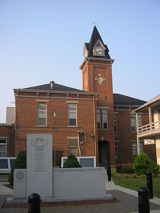
Harrison County is a county located in the U.S. state of Kentucky. As of the 2020 census, the population was 18,692. Its county seat is Cynthiana. The county was founded in 1793 and named for Colonel Benjamin Harrison, an advocate for Kentucky statehood, framer of the Kentucky Constitution, and Kentucky legislator.

<span class="mw-page-title-main">Bracken County, Kentucky</span> County in Kentucky, United States

Bracken County is a county located in the U.S. state of Kentucky. As of the 2020 census, the population was 8,400. Its county seat is Brooksville. The county was formed in 1796. Bracken County is included in the Cincinnati-Middletown, OH-KY-IN Metropolitan Statistical Area.

<span class="mw-page-title-main">Bourbon County, Kentucky</span> County in Kentucky, United States

Bourbon County is a county located in the U.S. state of Kentucky. As of the 2020 census, the population was 20,252. Its county seat is Paris. Bourbon County is part of the Lexington-Fayette, KY Metropolitan Statistical Area. It is one of Kentucky's nine original counties, and is best known for its historical association with bourbon whiskey.

<span class="mw-page-title-main">Alexandria, Kentucky</span> City in Kentucky, United States

Alexandria is a home rule-class city in Campbell County, Kentucky, in the United States. Along with Newport, it is one of the dual seats of the county. The population was 10,341 at the 2020 census.

<span class="mw-page-title-main">Cold Spring, Kentucky</span> City in Kentucky, United States

Cold Spring is a home rule-class city in Campbell County, Kentucky, in the United States. The population was 6,216 at the 2020 census. It is part of the Cincinnati-Northern Kentucky metropolitan area.

<span class="mw-page-title-main">Grayson, Kentucky</span> City in Kentucky, United States

Grayson is a home rule-class city in and the county seat of Carter County, Kentucky, United States, on U.S. Route 60 and Interstate 64 in the state's northeastern region. It is approximately 21 miles west of Ashland. Within the city limits, the population was 4,217 at the 2010 census. Along with Carter County, the city is closely associated with the nearby Huntington-Ashland, WV-KY-OH Metropolitan Statistical Area and is often erroneously included in the MSA being just 9 miles west of the M.S.A's western boundary.

<span class="mw-page-title-main">Berry, Kentucky</span> City in Kentucky, United States

Berry is a home rule-class city in Harrison County, Kentucky, in the United States. The city was formally incorporated by the state assembly in 1867 as "Berryville". It was renamed "Berry Station" two years later. The population was 264 at the 2010 census, down from 310 at the 2000 census.

<span class="mw-page-title-main">Covington, Kentucky</span> City in Kentucky, United States

Covington is a home rule-class city in Kenton County, Kentucky, United States. Located at the confluence of the Ohio and Licking rivers, it lies south of Cincinnati, Ohio, across the Ohio and west of Newport, Kentucky, across the Licking. It had a population of 40,691 at the 2020 census, making it the largest city in Northern Kentucky and the fifth-most populous city in the state. A part of the Cincinnati metropolitan area, it is one of Kenton County's two seats, along with Independence.

<span class="mw-page-title-main">Independence, Kentucky</span> City in Kentucky, United States

Independence is a home rule-class city in Kenton County, Kentucky, United States. It is one of its county's two seats of government. The population was 28,676 at the time of the 2020 census. It is the third largest city in Northern Kentucky after Covington and Florence, and is part of the Cincinnati metropolitan area.

<span class="mw-page-title-main">Louisa, Kentucky</span> City in Kentucky, United States

Louisa is a home-rule class city located in eastern Kentucky at the merger of the Levisa and Tug Forks into the Big Sandy River, which forms part of the state's border with West Virginia. It is the seat of Lawrence County. The population was 2,467 at the 2010 census and an estimated 2,375 in 2018.

<span class="mw-page-title-main">Beattyville, Kentucky</span> City in Kentucky, United States

Beattyville is a home rule class city in, and the county seat of, Lee County, Kentucky, United States. The city was formally established by the state assembly as "Beatty" in 1851 and incorporated in 1872. It was named for Samuel Beatty, a pioneer settler. The population was 1,307 at the 2010 census and an estimated 1,206 in 2018.

<span class="mw-page-title-main">Vanceburg, Kentucky</span> City in Kentucky, United States

Vanceburg is a home rule-class city in Lewis County, Kentucky, United States, along the Ohio River. The population was 1,428 at the 2020 census. It is the county seat of Lewis County.

<span class="mw-page-title-main">Sardis, Kentucky</span> City in Kentucky, United States

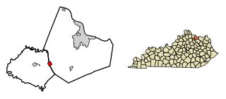
Sardis is a home rule-class city in Mason and Robertson counties in the U.S. state of Kentucky. The population was 60 as of the 2020 census, down from 103 in 2010.

<span class="mw-page-title-main">West Liberty, Kentucky</span> City in Kentucky, United States

West Liberty is a home rule-class city in Morgan County, Kentucky, United States. It is the county seat of Morgan County. As of the 2020 census, the city population was 3,215. It is located along the Licking River at the junction of Kentucky Route 7 and U.S. Route 460.

<span class="mw-page-title-main">Cincinnati metropolitan area</span> Metropolitan Statistical Area in the United States

The Cincinnati metropolitan area is a metropolitan area with its core in Ohio and Kentucky. Its largest city is Cincinnati and includes surrounding counties in the U.S. states of Ohio, Kentucky, and Indiana.

<span class="mw-page-title-main">Kentucky Route 3016</span> State highway in Kentucky, United States

Kentucky Route 3016 is a state highway in the Bluegrass region of Kentucky. The highway extends 2.082 miles (3.351 km) from KY 982 north to KY 36 and KY 356 in Cynthiana in central Harrison County. KY 3016 serves the south and west sides of the Harrison County seat. The highway was established north of U.S. Route 27 Business and KY 32 in 1987 and extended south to KY 982 in 2014.

References

  1. "2020 U.S. Gazetteer Files". United States Census Bureau. Retrieved March 18, 2022.
  2. 1 2 U.S. Geological Survey Geographic Names Information System: Cynthiana, Kentucky
  3. "Annual Estimates of the Resident Population for Incorporated Places in Kentucky: April 1, 2020 to July 1, 2022". United States Census Bureau. Retrieved May 26, 2023.
  4. "Summary and Reference Guide to House Bill 331 City Classification Reform" (PDF). Kentucky League of Cities. Retrieved December 30, 2014.
  5. 1 2 "Geographic Identifiers: 2010 Demographic Profile Data (G001): Cynthiana city, Kentucky". American Factfinder. U.S. Census Bureau. Retrieved June 29, 2017.[ dead link ]
  6. "Find a County". National Association of Counties. Archived from the original on May 31, 2011. Retrieved June 7, 2011.
  7. Gannett, Henry (1905). The Origin of Certain Place Names in the United States. Govt. Print. Off. p. 98.
  8. Rennick, Robert M. (1987). Kentucky Place Names. University Press of Kentucky. p. 77. Retrieved April 28, 2013.
  9. Collins, Lewis (1877). History of Kentucky. p. 321.
  10. "Civil War in Kentucky". www.trailsrus.com. Retrieved April 12, 2018.
  11. Penn, William A. (2016). Kentucky Rebel Town: Civil War Battles of Cynthiana and Harrison County. Lexington: Univ. Press of Kentucky. pp. 105, 175, 193, 205. ISBN   9780813167718.
  12. "A Chapter in the history of Meteorites by Walter Flight". www.meteoritehistory.info. Retrieved April 12, 2018.
  13. "A small town takes a big hit after coronavirus is confirmed in its midst". March 12, 2020.
  14. "Cynthiana, Kentucky Köppen Climate Classification (Weatherbase)". Weatherbase. Retrieved April 12, 2018.
  15. "NOWData – NOAA Online Weather Data". National Oceanic and Atmospheric Administration. Retrieved November 18, 2023.
  16. "Summary of Monthly Normals 1991–2020". National Oceanic and Atmospheric Administration. Retrieved November 18, 2023.
  17. "xmACIS2". National Oceanic and Atmospheric Administration. Retrieved November 20, 2023.
  18. "Kentucky Public Library Directory". Kentucky Department for Libraries and Archives. Archived from the original on January 11, 2019. Retrieved June 5, 2019.
  19. "Annual Estimates of the Resident Population for Incorporated Places in Kentucky: April 1, 2020 to July 1, 2022". United States Census Bureau. Retrieved May 26, 2023.
  20. "Census of Population and Housing". Census.gov. Retrieved June 4, 2015.
  21. "U.S. Census website". United States Census Bureau . Retrieved January 31, 2008.
  22. "KY Plant makes the most Post-It Notes in the world". WRDB News. July 13, 2014. Retrieved January 30, 2019.
  23. Sloan, Scott (October 28, 2010). "Kentuckian's zombie comic strip leads to AMC series". Lexington Herald-Leader . Retrieved October 29, 2011.