Whitesburg, Kentucky

Last updated

Whitesburg, Kentucky
Downtown Whitesburg Kentucky.JPG
Downtown Whitesburg
Letcher County Kentucky Incorporated and Unincorporated areas Whitesburg Highlighted 2182776.svg
Location in Letcher County, Kentucky
Coordinates: 37°7′4″N82°49′16″W / 37.11778°N 82.82111°W / 37.11778; -82.82111
Country United States
State Kentucky
County Letcher
IncorporatedMarch 6, 1876
Government
  Type Mayor-Council
  MayorTiffany Craft
   City Council
  • Margaret Hammonds
  • Sheila Shortt
  • Derek Barto
  • Mike Jackson
  • Larry Everidge
  • Wendy Little
Area
[1]
  Total3.20 sq mi (8.30 km2)
  Land3.13 sq mi (8.11 km2)
  Water0.07 sq mi (0.18 km2)
Elevation
1,171 ft (357 m)
Population
 (2020)
  Total1,773
  Estimate 
(2022) [2]
1,711
  Density566.09/sq mi (218.59/km2)
Time zone UTC-5 (Eastern (EST))
  Summer (DST) UTC-4 (EDT)
ZIP code
41858
Area code 606
FIPS code 21-82776
GNIS feature ID0506678
Website www.cityofwhitesburg.com

Whitesburg is a home rule-class city in and the county seat of Letcher County, Kentucky, United States. [3] The population was 2,139 at the 2010 census [4] and an estimated 1,875 in 2018. [5] It was named for John D. White, a state politician. [6]

Contents

History

Whitesburg was founded in 1842 on land offered by Stephen Hiram Hogg to build the county seat. [7] Previously called Summit city, it was renamed for John D. White who had introduced Letcher county's enactment bill in the State legislature. [8]

Geography

Whitesburg is located in central Letcher County at 37°7′4″N82°49′16″W / 37.11778°N 82.82111°W / 37.11778; -82.82111 (37.117867, -82.821068) [9] in the valley of the North Fork of the Kentucky River, five miles (8 km) west of the border of Kentucky and Virginia.

Kentucky Route 15 passes through the city, leading northwest 31 miles (50 km) to Hazard. It has its eastern terminus in the east part of Whitesburg at U.S. Route 119. US 119 leads northeast 11 miles (18 km) to U.S. Route 23 at Jenkins and southwest over Pine Mountain 20 miles (32 km) to Cumberland.

According to the United States Census Bureau, Whitesburg has a total area of 3.2 square miles (8.3 km2), of which 3.1 square miles (8.1 km2) are land and 0.1 square miles (0.2 km2), or 2.23%, are water. [10]

Climate

Whitesburg is located within a climatic transition zone between the humid subtropical climate and the humid continental climate zones. Summers are hot, humid and wet. July is the warmest month, with an average high of 86 °F (30 °C) and an average low of 63 °F (17 °C). Winters are generally cool to cold, with occasional snowfall. January is the coldest month, with an average high of 44 °F (7 °C) and an average low of 21 °F (−6 °C). May receives the most precipitation with an average of 5.83 inches (148 mm). The highest recorded temperature was 97 °F (36 °C) in 1998, and the lowest recorded temperature was −15 °F (−26 °C) in 1996. [11]

Climate data for Whitesburg, Kentucky
MonthJanFebMarAprMayJunJulAugSepOctNovDecYear
Record high °F (°C)72
(22)
76
(24)
84
(29)
88
(31)
91
(33)
95
(35)
96
(36)
96
(36)
97
(36)
91
(33)
83
(28)
75
(24)
97
(36)
Mean daily maximum °F (°C)44
(7)
49
(9)
58
(14)
67
(19)
75
(24)
82
(28)
85
(29)
85
(29)
80
(27)
69
(21)
59
(15)
47
(8)
67
(19)
Mean daily minimum °F (°C)24
(−4)
27
(−3)
33
(1)
41
(5)
51
(11)
60
(16)
64
(18)
63
(17)
55
(13)
43
(6)
34
(1)
27
(−3)
44
(7)
Record low °F (°C)−12
(−24)
−15
(−26)
−2
(−19)
19
(−7)
30
(−1)
42
(6)
51
(11)
48
(9)
36
(2)
24
(−4)
11
(−12)
1
(−17)
−15
(−26)
Average rainfall inches (mm)4.61
(117)
4.34
(110)
4.95
(126)
4.65
(118)
5.83
(148)
3.86
(98)
4.31
(109)
3.89
(99)
3.95
(100)
3.45
(88)
4.00
(102)
4.52
(115)
52.36
(1,330)
Source: The Weather Channel. [11]

Demographics

Historical population
CensusPop.Note
1900 194
1910 32165.5%
1920 706119.9%
1930 1,804155.5%
1940 1,616−10.4%
1950 1,393−13.8%
1960 1,77427.4%
1970 1,137−35.9%
1980 1,52534.1%
1990 1,6367.3%
2000 1,600−2.2%
2010 2,13933.7%
2020 1,773−17.1%
2022 (est.)1,711 [12] −3.5%
U.S. Decennial Census [13]

According to the census [14] of 2000, there were 1,600 people, 642 households, and 412 families residing in the city. The population density was 516.9 inhabitants per square mile (199.6/km2). There were 733 housing units at an average density of 236.8 per square mile (91.4/km2). The racial makeup of the city was 96.19% White, 0.62% African American, 2.62% Asian, 0.06% from other races, and 0.50% from two or more races. Hispanic or Latino of any race were 0.56% of the population.

There were 642 households, out of which 27.1% had children under the age of 18 living with them, 48.6% were married couples living together, 12.8% had a female householder with no husband present, and 35.8% were non-families. 34.3% of all households were made up of individuals, and 15.1% had someone living alone who was 65 years of age or older. The average household size was 2.21 and the average family size was 2.82.

In the city the population was spread out, with 18.6% under the age of 18, 7.8% from 18 to 24, 24.2% from 25 to 44, 25.4% from 45 to 64, and 24.1% who were 65 years of age or older. The median age was 45 years. For every 100 females, there were 79.0 males. For every 100 females age 18 and over, there were 76.1 males.

As a result of a survey taken subsequent to the census it was established that the city's population was made up of 3,100 residents. 1,241 households were left out of the census because neither the residents of Whitesburg's Housing Project nor residents of the Letcher Manor Nursing Home were counted in the census. When these facilities are included in the population count the number of city residents climbs to 3,100. [15]

The median income for a household in the city was $28,750, and the median income for a family was $35,714. Males had a median income of $31,339 versus $25,478 for females. The per capita income for the city was $20,202. About 22.0% of families and 23.1% of the population were below the poverty line, including 27.2% of those under age 18 and 13.9% of those age 65 or over.

Education

Whitesburg has a lending library, a branch of the Letcher County Library. [16]

Letcher County Public Schools is based in Whitesburg. The district operates seven schools, one high school, one alternative education center, and an area technology center. Whitesburg has two schools located within the city limits, Whitesburg Elementary and Whitesburg Middle, as well as Letcher County Central High School, which is located just outside the city limits in the neighboring community of Ermine. [17]

Media

Whitesburg's major newspaper is The Mountain Eagle . Founded by Nehemiah Webb in 1907, the weekly paper has been owned by the Gish family of Letcher County since 1956. The Eagle has won numerous awards for its coverage of strip mining and its environmental effects, as well as education, and political corruption. [18]

Whitesburg's oldest continuously operating radio station, WTCW-AM/WXKQ-FM, is located 5 miles (8 km) outside the city near the community of Mayking. The license holder is T.C.W. Broadcasting, Inc. and is one of 18 radio stations owned and operated by Forcht Broadcasting, a Forcht Group of Kentucky company. The public radio station licensed for Whitesburg, WMMT, is located at Appalshop in downtown Whitesburg.

Arts and culture

Facade of the Graham Memorial Presbyterian Church in Whitesburg (built in 1934 by Italian immigrant stonemasons), featuring the outline of a map of Italy Whitesburg-methodistchurch.jpg
Facade of the Graham Memorial Presbyterian Church in Whitesburg (built in 1934 by Italian immigrant stonemasons), featuring the outline of a map of Italy

Whitesburg is the home of Appalshop, a nonprofit aimed at helping people tell stories and educate others about Appalachia.

Notable people

Related Research Articles

<span class="mw-page-title-main">Perry County, Kentucky</span> County in Kentucky, United States

Perry County is a county in the U.S. state of Kentucky. As of the 2020 census, the population was 28,473. Its county seat is Hazard. The county was founded in 1820. Both the county and county seat are named for Commodore Oliver Hazard Perry, a naval hero in the War of 1812.

<span class="mw-page-title-main">Letcher County, Kentucky</span> County in Kentucky, United States

Letcher County is a county located in the U.S. state of Kentucky. As of the 2020 census, the population was 21,548. Its county seat is Whitesburg. It was created in 1842 from Harlan and Perry counties, and named for Robert P. Letcher, Governor of Kentucky from 1840 to 1844.

<span class="mw-page-title-main">Knott County, Kentucky</span> County in Kentucky, United States

Knott County is a county located in the U.S. state of Kentucky. As of the 2020 census, the population was 14,251. Its county seat is Hindman. The county was formed in 1884 and is named for James Proctor Knott, Governor of Kentucky (1883–1887). It is a prohibition or dry county. Its county seat is home to the Hindman Settlement School, founded as America's first settlement school. The Knott County town of Pippa Passes is home to Alice Lloyd College.

<span class="mw-page-title-main">Pineville, Kentucky</span> City in Kentucky, United States

Pineville is a home rule-class city in Bell County, Kentucky, United States. It is the seat of its county. The population was 1,732 as of the 2010 census. It is located on a small strip of land between the Cumberland River and Pine Mountain.

<span class="mw-page-title-main">Florence, Kentucky</span> City in Kentucky, United States

Florence is a city in Boone County, Kentucky, United States, part of the Cincinnati metropolitan area. The population was 31,946 at the 2020 census, making it the second-largest city in Northern Kentucky, the eighth-largest city in Kentucky and the state's largest that is not a county seat. Like all but the state's two largest cities, Florence is a home rule-class city under Kentucky state law.

<span class="mw-page-title-main">Raceland, Kentucky</span> City in Kentucky, United States

Raceland is a home rule-class city in Greenup County, Kentucky, United States, in the Ohio River valley. As of the 2010 census, the population was 2,424. It is part of the Huntington–Ashland metropolitan area.

<span class="mw-page-title-main">Cumberland, Kentucky</span> City in Kentucky, United States

Cumberland is a home rule-class city in Harlan County, Kentucky, in the United States. The population according to the 2010 Census was 2,237, down from 2,611 at the 2000 census. The city sits at the confluence of Looney Creek and the Poor Fork Cumberland River.

<span class="mw-page-title-main">Barbourville, Kentucky</span> City in Kentucky, United States

Barbourville is a home rule-class city in Knox County, Kentucky, in the United States. The population was 3,165 at the 2010 census, down from 3,589 at the 2000 census. It is the county seat of Knox County. The city was formally established by the state assembly in 1812. It was incorporated in 1854 and then reincorporated in 1856.

<span class="mw-page-title-main">Hyden, Kentucky</span> City in Kentucky, United States

Hyden is a home rule-class city in and the county seat of Leslie County, Kentucky, United States. The population was 365 at the 2010 census. It is located at the junction of U.S. Route 421 and Kentucky Route 80, along the Middle Fork of the Kentucky River.

<span class="mw-page-title-main">Blackey, Kentucky</span> City in Kentucky, United States

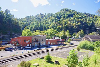
Blackey is an unincorporated community in Letcher County, Kentucky, in the United States. As of the 2010 census, the population was 120. It is located near the early settlement of Indian Bottom. Blackey is thought to have been named after Blackey Brown, one of its citizens.

<span class="mw-page-title-main">Fleming-Neon, Kentucky</span> City in Kentucky, United States

Fleming-Neon also known as Neon, is a home rule-class city in Letcher County, Kentucky, in the United States. The population was 770 at the 2010 census, down from 840 at the 2000 census.

<span class="mw-page-title-main">Jenkins, Kentucky</span> City in Kentucky, United States

Jenkins is a home rule-class city in Letcher County, Kentucky, United States. The population was 2,203 as of the 2010 census.

<span class="mw-page-title-main">McRoberts, Kentucky</span> Census-designated place in Kentucky, United States

McRoberts is an unincorporated community and census-designated place (CDP) in Letcher County, Kentucky, United States. The population was 741 at the 2020 United States Census, down from 784 at the 2010 census. McRoberts is in the Eastern Kentucky Coalfield region.

<span class="mw-page-title-main">Tompkinsville, Kentucky</span> City in Kentucky, United States

Tompkinsville is a home rule-class city in and the county seat of Monroe County, Kentucky, United States. The population was 2,309 at the 2020 census. The city was named after Vice President Daniel D. Tompkins who served under President James Monroe, for whom the county was named.

<span class="mw-page-title-main">Vicco, Kentucky</span> City in Kentucky, United States

Vicco is a Kentucky defunct city in Perry and Knott counties, Kentucky, United States as defined by Kentucky Act Acts Ch. 25. The population was 334 at the 2010 census.

<span class="mw-page-title-main">Plumcreek Township, Pennsylvania</span> Township in Pennsylvania, United States

Plumcreek Township is a township that is located in Armstrong County, Pennsylvania, United States. The population was 2,106 at the time of the 2020 census, a decrease from the figure of 2,375 that was tabulated in 2010.

<span class="mw-page-title-main">Hyndman, Pennsylvania</span> Borough in Pennsylvania, United States

Hyndman is a borough in Bedford County, Pennsylvania, United States. As of the 2020 census, the population was 863.

<span class="mw-page-title-main">Letcher, South Dakota</span> Town in South Dakota, United States

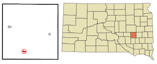
Letcher is a town in Sanborn County, South Dakota, United States. The population was 159 at the 2020 census.

Tom Gish was an American newspaper reporter and editor, best known for his work as the owner and co-editor of The Mountain Eagle weekly newspaper alongside his wife, Pat Gish, in Whitesburg, the county seat of Letcher County, Kentucky, where his paper was the first in the eastern part of the state to challenge the damage caused to the environment resulting from strip mining.

The Mountain Eagle is a local weekly newspaper published in Whitesburg, Kentucky. It is the main newspaper of Letcher County, Kentucky and one of the primary newspapers of the Eastern Kentucky Coalfield.

References

  1. "2020 U.S. Gazetteer Files". United States Census Bureau. Retrieved March 18, 2022.
  2. "Annual Estimates of the Resident Population for Incorporated Places in Kentucky: April 1, 2020 to July 1, 2022". United States Census Bureau. Retrieved May 26, 2023.
  3. "Find a County". National Association of Counties. Retrieved June 7, 2011.
  4. "Total Population: 2010 Census DEC Summary File 1 (P1), Whitesburg city, Kentucky". data.census.gov. U.S. Census Bureau. Retrieved February 12, 2020.
  5. "Population and Housing Unit Estimates" . Retrieved December 20, 2019.
  6. "About". City of Whitesburg. Retrieved April 19, 2023.
  7. Rennick, Robert (March 1, 2002). "Letcher County - Post Offices". County Histories of Kentucky.
  8. "From Tiny Summit City to a Thriving County Seat". usgenwebsites.org. Retrieved April 19, 2023.
  9. "US Gazetteer files: 2010, 2000, and 1990". United States Census Bureau. February 12, 2011. Retrieved April 23, 2011.
  10. "U.S. Gazetteer Files: 2019: Places: Kentucky". U.S. Census Bureau Geography Division. Retrieved February 12, 2020.
  11. 1 2 "MONTHLY AVERAGES for Whitesburg, KY". The Weather Channel . Retrieved April 23, 2010.
  12. "Annual Estimates of the Resident Population for Incorporated Places in Kentucky: April 1, 2020 to July 1, 2022". United States Census Bureau. Retrieved May 26, 2023.
  13. "Census of Population and Housing". Census.gov. Retrieved June 4, 2015.
  14. "U.S. Census website". United States Census Bureau . Retrieved January 31, 2008.
  15. (2 April 2008), Bill would move Whitesburg from fifth- to fourth-class city, Whitesburg, Kentucky, The Mountain Eagle. Retrieved on 2008-05-13.
  16. "Kentucky Public Library Directory". Kentucky Department for Libraries and Archives. Archived from the original on January 11, 2019. Retrieved June 5, 2019.
  17. "Letcher County Public Schools". www.letcher.kyschools.us. Retrieved September 5, 2023.
  18. E. Ky. newsman Tom Gish dead at 82 Lexington Herald-Leader . Retrieved on November 21, 2008.