Flemingsburg, Kentucky

Last updated

Flemingsburg, Kentucky
Flemingsburg, Kentucky downtown.jpg
Motto: 
"The friendly town that hospitality built"
Fleming County Kentucky Incorporated and Unincorporated areas Flemingsburg Highlighted 2127856.svg
Location of Flemingsburg in Fleming County, Kentucky.
Coordinates: 38°25′20″N83°44′50″W / 38.42222°N 83.74722°W / 38.42222; -83.74722
Country United States
State Kentucky
County Fleming
Area
[1]
  Total2.70 sq mi (7.00 km2)
  Land2.69 sq mi (6.97 km2)
  Water0.01 sq mi (0.03 km2)
Elevation
[2]
814 ft (248 m)
Population
 (2020)
  Total2,953
  Estimate 
(2022) [3]
2,969
  Density1,097.36/sq mi (423.67/km2)
Time zone UTC-5 (Eastern (EST))
  Summer (DST) UTC-4 (EDT)
ZIP code
41041
Area code 606
FIPS code 21-27856
GNIS feature ID2403616 [2]
Website www.flemingsburgky.org

Flemingsburg is a home rule-class city [4] in Fleming County, Kentucky, in the United States. The population was 2,953 at the 2020 census [5] , up from 2,658 at the 2010 census. [6] It is the seat of Fleming County. [7]

Contents

Geography

Flemingsburg is located northwest of the center of Fleming County in northeastern Kentucky, 17 miles (27 km) south of Maysville, 31 miles (50 km) northeast of Mt. Sterling, and 38 miles (61 km) northeast of Paris.

According to the United States Census Bureau, Flemingsburg has a total area of 2.0 square miles (5.3 km2), of which 0.01 square miles (0.02 km2), or 0.33%, is water. [6]

Climate

The climate in this area is characterized by hot, humid summers and generally mild to cool winters. According to the Köppen Climate Classification system, Flemingsburg has a humid subtropical climate, abbreviated "Cfa" on climate maps. [8]

History

Flemingsburg was founded in 1797 by George S. Stockton, a native Virginian, who named the town and county after his half-brother Colonel John Fleming. [9] It has been the seat of Fleming County since its formation and was formally incorporated by the state assembly in 1812. [10] [11]

Demographics

Historical population
CensusPop.Note
1800 123
1830 648
1840 591−8.8%
1850 75928.4%
1870 425
1880 81190.8%
1890 1,17244.5%
1900 1,2688.2%
1910 1,219−3.9%
1920 1,56228.1%
1930 1,265−19.0%
1940 1,54221.9%
1950 1,502−2.6%
1960 2,06737.6%
1970 2,48320.1%
1980 2,83514.2%
1990 3,0718.3%
2000 3,010−2.0%
2010 2,658−11.7%
2020 2,95311.1%
2022 (est.)2,969 [12] 0.5%
U.S. Decennial Census [13]

As of the census [5] of 2000, there were 3,010 people, 1,294 households, and 821 families residing in the city. The population density was 1,178.2 inhabitants per square mile (454.9/km2). There were 1,434 housing units at an average density of 561.3 per square mile (216.7/km2). The racial makeup of the city was 92.72% White, 5.05% African American, 0.10% Native American, 0.40% Asian, 0.43% from other races, and 1.30% from two or more races. Hispanic or Latino of any race were 1.03% of the population.

There were 1,294 households, out of which 29.3% had children under the age of 18 living with them, 45.5% were married couples living together, 14.8% had a female householder with no husband present, and 36.5% were non-families. 33.9% of all households were made up of individuals, and 18.2% had someone living alone who was 65 years of age or older. The average household size was 2.25 and the average family size was 2.87.

In the city, the population was spread out, with 23.3% under the age of 18, 7.9% from 18 to 24, 25.2% from 25 to 44, 23.2% from 45 to 64, and 20.5% who were 65 years of age or older. The median age was 41 years. For every 100 females, there were 81.3 males. For every 100 females age 18 and over, there were 74.1 males.

The median income for a household in the city was $23,708, and the median income for a family was $33,365. Males had a median income of $26,550 versus $21,165 for females. The per capita income for the city was $14,914. About 15.0% of families and 19.0% of the population were below the poverty line, including 23.5% of those under age 18 and 26.8% of those age 65 or over.

Education

Flemingsburg has a lending library, the Fleming County Public Library. [14]

Notable people

Related Research Articles

<span class="mw-page-title-main">Robertson County, Kentucky</span> County in Kentucky, United States

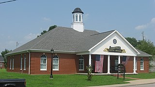
Robertson County is a county located in the U.S. Commonwealth of Kentucky. As of the 2020 census, the population was 2,193. Its county seat is Mount Olivet. The county is named for George Robertson, a Kentucky Congressman from 1817 to 1821. It is Kentucky's smallest county by both total area and by population.

<span class="mw-page-title-main">Fleming County, Kentucky</span> County in Kentucky, United States

Fleming County is a county located in the U.S. state of Kentucky. As of the 2020 census, the population was 15,082. Its county seat is Flemingsburg. The county was formed in 1798 and named for Colonel John Fleming, an Indian fighter and early settler. It is a moist county. In 1998, the Kentucky General Assembly designated Fleming County as the Covered Bridge Capital of Kentucky.

<span class="mw-page-title-main">Whiteland, Indiana</span> Town in Indiana, United States

Whiteland is a town in Pleasant, Franklin and Clark townships, Johnson County, Indiana, United States. The population was 4,599 at the 2020 census.

<span class="mw-page-title-main">Sharpsburg, Kentucky</span> City in Kentucky, United States

Sharpsburg is a home rule-class city in Bath County, Kentucky, in the United States. The population was 323 as of the 2010 U.S. census. It is part of the Mount Sterling micropolitan area.

<span class="mw-page-title-main">Liberty, Kentucky</span> City in Kentucky, United States

Liberty is a home rule-class city in Casey County, Kentucky, in the United States. It is the seat of its county. Its population was 2,168 at the 2010 U.S. census.

<span class="mw-page-title-main">Albany, Kentucky</span> City in Kentucky, United States

Albany is a home rule-class city in Clinton County, Kentucky, in the United States. The population was 2,033 at the 2010 census. It is the county seat of Clinton County. It is located on U.S. Route 127, about 6 miles (10 km) north of the Tennessee border.

<span class="mw-page-title-main">Ewing, Kentucky</span> City in Kentucky, United States

Ewing is a home rule-class city in Fleming County, Kentucky, in the United States. The population was 264 at the 2010 census.

<span class="mw-page-title-main">Lancaster, Kentucky</span> City in Kentucky, United States

Lancaster is a home rule-class city in Garrard County, Kentucky, in the United States. It is the seat of its county. As of the year 2020 U.S. census, the city population was 3,901.

<span class="mw-page-title-main">Blaine, Kentucky</span> City in Kentucky, United States

Blaine is a home rule-class city in Lawrence County, Kentucky, United States. The population was 47 at the 2010 census, down from 245 at the 2000 census.

<span class="mw-page-title-main">Fleming-Neon, Kentucky</span> City in Kentucky, United States

Fleming-Neon also known as Neon, is a home rule-class city in Letcher County, Kentucky, in the United States. The population was 770 at the 2010 census, down from 840 at the 2000 census.

<span class="mw-page-title-main">Kuttawa, Kentucky</span> City in Kentucky, United States

Kuttawa is a home rule-class city in Lyon County, Kentucky, in the United States. The population was 649 as of the 2010 census, up from 596 in 2000.

<span class="mw-page-title-main">Calhoun, Kentucky</span> City in Kentucky, United States

Calhoun is a home rule-class city in McLean County, Kentucky, United States. The population was 725 at the 2020 census. It is the county seat of McLean County. It is included in the Owensboro, Kentucky Metropolitan Statistical Area.

<span class="mw-page-title-main">Frenchburg, Kentucky</span> City in Kentucky, United States

Frenchburg is a home rule-class city in Menifee County, Kentucky, in the United States. The population was 601 at the 2020 census, up from 486 in 2010. It is the seat and only incorporated city in its rural county. It is located at the junction of U.S. Route 460 and Kentucky Route 36. Logging is the primary industry.

<span class="mw-page-title-main">Edmonton, Kentucky</span> City in Kentucky, United States

Edmonton is a home rule-class city in and the county seat of Metcalfe County, Kentucky, United States. It is part of the Glasgow Micropolitan Statistical Area. The population was 1,671 at the 2020 census.

<span class="mw-page-title-main">Mount Sterling, Kentucky</span> City in Kentucky, United States

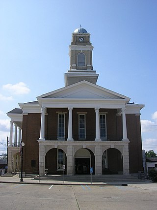
Mount Sterling, often written as Mt. Sterling, is a home rule-class city in Montgomery County, Kentucky, United States. The population was 7,558 as of the 2020 census, up from 6,895 in 2010. It is the county seat of Montgomery County and the principal city of the Mount Sterling micropolitan area.

<span class="mw-page-title-main">Beaver Dam, Kentucky</span> City in Kentucky, United States

Beaver Dam is a home rule-class city in Ohio County, Kentucky, in the United States. The population was 3,409 at the 2010 census, and it is the most populous community in the county. It is named for the Beaver Dam Baptist Church which predates the town by several decades. The city was formally incorporated by the state assembly in 1873.

<span class="mw-page-title-main">Jamestown, Kentucky</span> City in Kentucky, United States

Jamestown is a home rule-class city in Russell County, Kentucky, in the United States. It is the seat of its county. The population was 1,794 at the 2010 U.S. census.

<span class="mw-page-title-main">Taylorsville, Kentucky</span> City in Kentucky, United States

Taylorsville is a home rule-class city in Spencer County, Kentucky, United States. It is the county seat of Spencer County. As of the 2020 census, the city had a total population of 1,256. It was incorporated in 1829.

<span class="mw-page-title-main">Elkton, Kentucky</span> City in Kentucky, United States

Elkton is a home rule-class city in and the county seat of Todd County, Kentucky, United States. The population was 2,062 at the 2010 census.

<span class="mw-page-title-main">Williamstown, Kentucky</span> City in Kentucky, United States

Williamstown is a home-rule-class city in Grant and Pendleton counties in the U.S. state of Kentucky. The population was 3,925 at the 2010 census, up from 3,227 as of the 2000 census. It is the county seat of Grant County.

References

  1. "2020 U.S. Gazetteer Files". United States Census Bureau. Retrieved March 18, 2022.
  2. 1 2 U.S. Geological Survey Geographic Names Information System: Flemingsburg, Kentucky
  3. "Annual Estimates of the Resident Population for Incorporated Places in Kentucky: April 1, 2020 to July 1, 2022". United States Census Bureau. Retrieved May 26, 2023.
  4. "Summary and Reference Guide to House Bill 331 City Classification Reform" (PDF). Kentucky League of Cities. Retrieved December 30, 2014.
  5. 1 2 "U.S. Census website". United States Census Bureau . Retrieved January 31, 2008.
  6. 1 2 "Geographic Identifiers: 2010 Census Summary File 1 (G001), Flemingsburg city, Kentucky". American FactFinder. U.S. Census Bureau. Archived from the original on February 13, 2020. Retrieved May 20, 2016.
  7. "Find a County". National Association of Counties. Archived from the original on May 31, 2011. Retrieved June 7, 2011.
  8. Climate Summary for Flemingsburg, Kentucky
  9. Rennick, Robert M. (1987). Kentucky Place Names. University Press of Kentucky. p. 103. Retrieved April 28, 2013.
  10. Commonwealth of Kentucky. Office of the Secretary of State. Land Office. "Flemingsburg, Kentucky". Accessed 26 July 2013.
  11. Collins, Lewis (1877). History of Kentucky. p. 230.
  12. "Annual Estimates of the Resident Population for Incorporated Places in Kentucky: April 1, 2020 to July 1, 2022". United States Census Bureau. Retrieved May 26, 2023.
  13. "Census of Population and Housing". Census.gov. Retrieved June 4, 2015.
  14. "Kentucky Public Library Directory". Kentucky Department for Libraries and Archives. Archived from the original on January 11, 2019. Retrieved June 5, 2019.