Greensburg, Kentucky

Last updated

Greensburg, Kentucky
Downtown Greensburg Kentucky.jpg
Downtown Greensburg
Greensburg Seal.png
Green County Kentucky Incorporated and Unincorporated areas Greensburg Highlighted 2132968.svg
Location of Greensburg in Green County, Kentucky.
Coordinates: 37°15′35″N85°29′52″W / 37.25972°N 85.49778°W / 37.25972; -85.49778
Country United States
State Kentucky
County Green
Established1794
Incorporated1795
Named for its county
Government
   Mayor John Shuffett
Area
[1]
  Total2.04 sq mi (5.29 km2)
  Land2.03 sq mi (5.27 km2)
  Water0.01 sq mi (0.02 km2)
Elevation
600 ft (183 m)
Population
 (2020)
  Total2,179
  Estimate 
(2022) [2]
2,208
  Density1,071.82/sq mi (413.73/km2)
Time zone UTC-6 (Central (CST))
  Summer (DST) UTC-5 (CDT)
ZIP code
42743
Area code(s) 270 & 364
FIPS code 21-32968
GNIS feature ID0493339
Website www.greensburgonline.com

Greensburg is a home rule-class city [3] in and the county seat of Green County, Kentucky, United States. [4] The population was 2,163 at the 2010 census, [5] down from 2,396 at the 2000 census.

Contents

The Downtown Greensburg Historic District is on the National Register of Historic Places and includes the oldest courthouse west of the Allegheny Mountains.

Geography

Greensburg is located east of the center of Green County at 37°15′35″N85°29′52″W / 37.25972°N 85.49778°W / 37.25972; -85.49778 (37.259665, -85.497863), [6] on the north side of the Green River, a west-flowing tributary of the Ohio River. U.S. Route 68 passes through the city as Main Street; it leads northeast 11 miles (18 km) to Campbellsville and southwest 25 miles (40 km) to Edmonton. Kentucky Route 61 joins US 68 on Main Street through Greensburg; KY 61 leads northwest 40 miles (64 km) to Elizabethtown and southeast 19 miles (31 km) to Columbia.

According to the United States Census Bureau, Greensburg has a total area of 2.1 square miles (5.4 km2), of which 0.01 square miles (0.03 km2), or 0.59%, is water. [5]

Climate

The climate in this area is characterized by hot, humid summers and generally mild to cool winters. According to the Köppen Climate Classification system, Greensburg has a humid subtropical climate, abbreviated "Cfa" on climate maps. [7]

The highest recorded temperature at Greensburg was 114 °F (46 °C) on July 28, 1930, the highest temperature ever recorded in Kentucky. [8]

Climate data for Greensburg, Kentucky, 1991–2020 normals, extremes 1896–2016
MonthJanFebMarAprMayJunJulAugSepOctNovDecYear
Record high °F (°C)82
(28)
81
(27)
89
(32)
97
(36)
99
(37)
107
(42)
114
(46)
110
(43)
108
(42)
98
(37)
84
(29)
78
(26)
114
(46)
Mean maximum °F (°C)66.7
(19.3)
71.3
(21.8)
79.0
(26.1)
85.7
(29.8)
88.2
(31.2)
94.1
(34.5)
96.6
(35.9)
96.5
(35.8)
92.8
(33.8)
85.3
(29.6)
77.8
(25.4)
67.6
(19.8)
98.2
(36.8)
Average high °F (°C)44.7
(7.1)
49.4
(9.7)
58.6
(14.8)
69.5
(20.8)
77.8
(25.4)
85.4
(29.7)
88.4
(31.3)
88.2
(31.2)
82.4
(28.0)
71.3
(21.8)
58.6
(14.8)
58.3
(14.6)
69.4
(20.8)
Daily mean °F (°C)35.1
(1.7)
38.6
(3.7)
46.5
(8.1)
56.3
(13.5)
65.7
(18.7)
74.0
(23.3)
77.6
(25.3)
76.4
(24.7)
69.6
(20.9)
57.8
(14.3)
46.4
(8.0)
38.6
(3.7)
56.9
(13.8)
Average low °F (°C)25.5
(−3.6)
27.8
(−2.3)
34.4
(1.3)
43.1
(6.2)
53.6
(12.0)
62.6
(17.0)
66.7
(19.3)
64.5
(18.1)
56.8
(13.8)
44.3
(6.8)
34.3
(1.3)
29.0
(−1.7)
45.2
(7.3)
Mean minimum °F (°C)4.0
(−15.6)
9.3
(−12.6)
18.6
(−7.4)
26.7
(−2.9)
38.1
(3.4)
49.4
(9.7)
55.5
(13.1)
54.1
(12.3)
41.3
(5.2)
29.6
(−1.3)
20.8
(−6.2)
9.4
(−12.6)
−0.1
(−17.8)
Record low °F (°C)−25
(−32)
−29
(−34)
−4
(−20)
13
(−11)
27
(−3)
37
(3)
39
(4)
42
(6)
25
(−4)
17
(−8)
−3
(−19)
−19
(−28)
−29
(−34)
Average precipitation inches (mm)3.87
(98)
4.23
(107)
4.76
(121)
4.84
(123)
5.05
(128)
4.74
(120)
4.92
(125)
3.22
(82)
4.00
(102)
3.73
(95)
3.68
(93)
4.68
(119)
51.72
(1,313)
Average precipitation days (≥ 0.01 in)9.79.010.710.710.110.79.67.17.37.78.610.6111.8
Source 1: NOAA [9]
Source 2: National Weather Service (mean maxima/minima 19812010) [10]

History

The 1780 settlement was originally known as "Glover's Station", for local landowner John Glover, who received 193 acres (0.78 km2) in the area as a military grant after the American Revolution. [11]

Following the establishment of Green County (named for Revolutionary War Maj. General Nathanael Greene [11] ) from parts of Lincoln and Nelson counties in 1792, Greensburg was laid out and established two years later as its eponymous seat of government. [12] It was incorporated as a city a year after that. [11] The central Public Square was also laid out in 1795 and has been retained as designed since then, with the only changes being the paving of the square with concrete and the installation of concrete dividers and parking meters in the four quadrants. [13]

The first post office arrived in 1807 and was variously known as "Greensburg" and "Greensburg Court House" during the early 19th century. [11]

The first courthouse in Greensburg was established in 1803. [14]

The first bank, Greensburg Independent Bank, was established in 1818. [14]

The first known school in Greensburg, called Greenburg Academy, was open from 1815 to 1818. [14]

Demographics

Historical population
CensusPop.Note
1800 70
1810 13288.6%
1830 669
1840 585−12.6%
1860 536
1870 351−34.5%
1880 62076.6%
1890 552−11.0%
1900 5642.2%
1910 450−20.2%
1920 4888.4%
1930 77057.8%
1940 1,17652.7%
1950 1,032−12.2%
1960 2,334126.2%
1970 1,990−14.7%
1980 2,37719.4%
1990 1,990−16.3%
2000 2,39620.4%
2010 2,163−9.7%
2020 2,1790.7%
2022 (est.)2,208 [15] 1.3%
U.S. Decennial Census [16]

As of the census [17] of 2000, there were 2,396 people, 1,061 households, and 648 families residing in the city. The population density was 1,255.4 inhabitants per square mile (484.7/km2). There were 1,190 housing units at an average density of 623.5 per square mile (240.7/km2). The racial makeup of the city was 92.99% White, 4.63% African American, 0.08% Native American, 0.38% Asian, 0.50% from other races, and 1.42% from two or more races. Hispanic or Latino of any race were 0.96% of the population.

There were 1,061 households, out of which 24.8% had children under the age of 18 living with them, 43.6% were married couples living together, 14.1% had a female householder with no husband present, and 38.9% were non-families. 37.1% of all households were made up of individuals, and 21.3% had someone living alone who was 65 years of age or older. The average household size was 2.12 and the average family size was 2.75.

In the city, the population was spread out, with 21.5% under the age of 18, 7.7% from 18 to 24, 22.1% from 25 to 44, 23.4% from 45 to 64, and 25.3% who were 65 years of age or older. The median age was 44 years. For every 100 females, there were 78.5 males. For every 100 females age 18 and over, there were 71.5 males.

The median income for a household in the city was $20,556, and the median income for a family was $29,818. Males had a median income of $26,065 versus $18,031 for females. The per capita income for the city was $14,296. About 21.3% of families and 24.8% of the population were below the poverty line, including 34.8% of those under age 18 and 13.5% of those age 65 or over.

Education

Greensburg has a lending library, the Green County Public Library. [18]

The public school system, Green County Public Schools, consists of 4 different schools. As of 2021, the school system consists of 1,648 students. [19]

Events

Greensburg holds an annual festival called Cow Days [20]

Notable people

Related Research Articles

<span class="mw-page-title-main">Nelson County, Kentucky</span> County in Kentucky, United States

Nelson County is a county located in the U.S. state of Kentucky. As of the 2020 census, the population was 48,065. Its county seat is Bardstown. Nelson County comprises the Bardstown, KY Micropolitan Statistical Area, which is also included in the Louisville/Jefferson County-Elizabethtown-Madison, KY-IN Combined Statistical Area.

<span class="mw-page-title-main">Lincoln County, Kentucky</span> County in Kentucky, United States

Lincoln County is a county located in south-central Kentucky. As of the 2020 census, the population was 24,275. Its county seat is Stanford. Lincoln County is part of the Danville, KY Micropolitan Statistical Area.

<span class="mw-page-title-main">Green County, Kentucky</span> County in Kentucky, United States

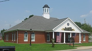
Green County is a county located in the U.S. state of Kentucky. Its county seat and only municipality is Greensburg. Green was a prohibition or dry county until 2015.

<span class="mw-page-title-main">Greensburg, Kansas</span> City in Kiowa County, Kansas

Greensburg is a city in, and the county seat of, Kiowa County, Kansas, United States. As of the 2020 United States census, the population of the city was 740. It is home to the world's largest hand-dug well. On the evening of May 4, 2007, Greensburg was devastated by an EF5 tornado that leveled at least 95 percent of the city and killing eleven people between the ages of 46 and 84. Today, Greensburg stands as a model "green town", often described as the greenest in America. The hospital, city hall, and school have all been built to the highest certification level issued by Leadership in Energy and Environmental Design (LEED).

<span class="mw-page-title-main">Hiseville, Kentucky</span> Unincorporated community in Kentucky, United States

Hiseville is an unincorporated community and census-designated place (CDP) in Barren County, Kentucky, United States. The population was 240 at the 2010 census. It is part of the Glasgow Micropolitan Statistical Area. Hiseville was a city until it disincorporated in 2004.

<span class="mw-page-title-main">Liberty, Kentucky</span> City in Kentucky, United States

Liberty is a home rule-class city in Casey County, Kentucky, in the United States. It is the seat of its county. Its population was 2,168 at the 2010 U.S. census.

<span class="mw-page-title-main">Winchester, Kentucky</span> City in Kentucky, United States

Winchester is a home rule-class city in and the county seat of Clark County, Kentucky, United States. The population was 18,368 at the 2010 census. It is part of the Lexington-Fayette, KY Metropolitan Statistical Area. Winchester is located roughly halfway between Lexington and Mt. Sterling.

<span class="mw-page-title-main">Flemingsburg, Kentucky</span> City in Kentucky, United States

Flemingsburg is a home rule-class city in Fleming County, Kentucky, in the United States. The population was 2,658 at the 2010 census, down from 3,010 at the 2000 census. It is the seat of Fleming County.

<span class="mw-page-title-main">Greenup, Kentucky</span> City in Kentucky, United States

Greenup is a home rule-class city located at the confluence of the Little Sandy River with the Ohio River in Greenup County, Kentucky, United States. The population was 1,188 at the 2010 census. Greenup is one of three county seats in the Commonwealth of Kentucky to share its name with its county; the other two being Harlan and Henderson.

<span class="mw-page-title-main">Blaine, Kentucky</span> City in Kentucky, United States

Blaine is a home rule-class city in Lawrence County, Kentucky, United States. The population was 47 at the 2010 census, down from 245 at the 2000 census.

<span class="mw-page-title-main">Hyden, Kentucky</span> City in Kentucky, United States

Hyden is a home rule-class city in and the county seat of Leslie County, Kentucky, United States. The population was 365 at the 2010 census. It is located at the junction of U.S. Route 421 and Kentucky Route 80, along the Middle Fork of the Kentucky River.

<span class="mw-page-title-main">Vanceburg, Kentucky</span> City in Kentucky, United States

Vanceburg is a home rule-class city in Lewis County, Kentucky, United States, along the Ohio River. The population was 1,428 at the 2020 census. It is the county seat of Lewis County.

<span class="mw-page-title-main">Russellville, Kentucky</span> City in Kentucky, United States

Russellville is a home rule-class city in Logan County, Kentucky, in the United States. It is the seat of its county. The population was 6,960 at the time of the 2010 census.

<span class="mw-page-title-main">Kuttawa, Kentucky</span> City in Kentucky, United States

Kuttawa is a home rule-class city in Lyon County, Kentucky, in the United States. The population was 649 as of the 2010 census, up from 596 in 2000.

<span class="mw-page-title-main">Stearns, Kentucky</span> Census-designated place in Kentucky, United States

Stearns is an unincorporated community and census-designated place (CDP) in McCreary County, Kentucky, United States. The population was 1,365 at the 2020 census. It was founded by Justus Smith Stearns.

<span class="mw-page-title-main">Calhoun, Kentucky</span> City in Kentucky, United States

Calhoun is a home rule-class city in McLean County, Kentucky, United States. The population was 725 at the 2020 census. It is the county seat of McLean County. It is included in the Owensboro, Kentucky Metropolitan Statistical Area.

<span class="mw-page-title-main">Edmonton, Kentucky</span> City in Kentucky, United States

Edmonton is a home rule-class city in and the county seat of Metcalfe County, Kentucky, United States. It is part of the Glasgow Micropolitan Statistical Area. The population was 1,671 at the 2020 census.

<span class="mw-page-title-main">Mount Sterling, Kentucky</span> City in Kentucky, United States

Mount Sterling, often written as Mt. Sterling, is a home rule-class city in Montgomery County, Kentucky, United States. The population was 7,558 as of the 2020 census, up from 6,895 in 2010. It is the county seat of Montgomery County and the principal city of the Mount Sterling micropolitan area.

<span class="mw-page-title-main">Campbellsville, Kentucky</span> City in Kentucky, United States

Campbellsville is a city in central Kentucky founded in 1817 by Andrew Campbell. It is known for Campbellsville University, Taylor Regional Hospital health care system, its historic downtown, and the proximity to Green River Lake State Park. Campbellsville is the county seat of Taylor County, with a geographic boundary shaped like a heart. Campbellsville celebrated its bicentennial on July 4, 2017.

<span class="mw-page-title-main">Elkton, Kentucky</span> City in Kentucky, United States

Elkton is a home rule-class city in and the county seat of Todd County, Kentucky, United States. The population was 2,062 at the 2010 census.

References

  1. "2020 U.S. Gazetteer Files". United States Census Bureau. Retrieved March 18, 2022.
  2. "Annual Estimates of the Resident Population for Incorporated Places in Kentucky: April 1, 2020 to July 1, 2022". United States Census Bureau. Retrieved May 26, 2023.
  3. "Summary and Reference Guide to House Bill 331 City Classification Reform" (PDF). Kentucky League of Cities. Retrieved December 30, 2014.
  4. "Find a County". National Association of Counties. Archived from the original on May 31, 2011. Retrieved June 7, 2011.
  5. 1 2 "Geographic Identifiers: 2010 Demographic Profile Data (G001): Greensburg city, Kentucky". American Factfinder. U.S. Census Bureau. Retrieved December 13, 2016.[ dead link ]
  6. "US Gazetteer files: 2010, 2000, and 1990". United States Census Bureau. February 12, 2011. Retrieved April 23, 2011.
  7. Climate Summary for Greensburg, Kentucky
  8. "State Climate Extremes Committee" . Retrieved April 7, 2023.
  9. "U.S. Climate Normals Quick Access – Station: Greensburg, KY". National Oceanic and Atmospheric Administration. Retrieved March 12, 2023.
  10. "NOAA Online Weather Data – NWS Louisville". National Weather Service. Retrieved March 12, 2023.
  11. 1 2 3 4 Rennick, Robert M. (1987). Kentucky Place Names. University Press of Kentucky. p. 125. Retrieved April 28, 2013.
  12. Commonwealth of Kentucky. Office of the Secretary of State. Land Office. "Greensburg, Kentucky". Accessed 28 July 2013.
  13. MRA NRHP. "Green County".
  14. 1 2 3 "About Green County - Green County". greencounty.ky.gov. Retrieved December 7, 2021.
  15. "Annual Estimates of the Resident Population for Incorporated Places in Kentucky: April 1, 2020 to July 1, 2022". United States Census Bureau. Retrieved May 26, 2023.
  16. "Census of Population and Housing". Census.gov. Retrieved June 4, 2015.
  17. "U.S. Census website". United States Census Bureau . Retrieved January 31, 2008.
  18. "Kentucky Public Library Directory". Kentucky Department for Libraries and Archives. Archived from the original on January 11, 2019. Retrieved June 5, 2019.
  19. "Green County School District (2021-22) | Greensburg, KY". www.publicschoolreview.com. Retrieved December 7, 2021.
  20. "Greensburg Cow Days Festival 2022, a Festival in Greensburg, Kentucky". festivalnet.com. Retrieved December 6, 2021.