Frenchburg, Kentucky

Last updated

Frenchburg, Kentucky
East on Walnut toward downtown Frenchburg.jpg
Walnut Street
Menifee County Kentucky Incorporated and Unincorporated areas Frenchburg Highlighted 2129260.svg
Location in Menifee County, Kentucky
Coordinates: 37°57′11″N83°37′38″W / 37.95306°N 83.62722°W / 37.95306; -83.62722
Country United States
State Kentucky
County Menifee
Area
[1]
  Total0.84 sq mi (2.18 km2)
  Land0.84 sq mi (2.17 km2)
  Water0.00 sq mi (0.00 km2)
Elevation
873 ft (266 m)
Population
 (2020) [2]
  Total601
  Density715.48/sq mi (276.33/km2)
Time zone UTC-5 (Eastern (EST))
  Summer (DST) UTC-4 (EDT)
ZIP code
40322
Area code 606
FIPS code 21-29260
GNIS feature ID0512254

Frenchburg is a home rule-class city in Menifee County, Kentucky, in the United States. The population was 601 at the 2020 census, [2] up from 486 in 2010. It is the seat and only incorporated city in its rural county. [3] It is located at the junction of U.S. Route 460 and Kentucky Route 36. Logging is the primary industry. [4]

Contents

Frenchburg is part of the Mount Sterling Micropolitan Statistical Area.

History

The historic Caudel House Caudel House on Blythe Branch, in Frenchburg, Kentucky.jpg
The historic Caudel House

Frenchburg was laid out in 1869 to be the county seat of newly formed Menifee County and was named for Robert French, a local lawyer and judge. [5] [6] It was formally incorporated by the state assembly in 1871. [7]

Frenchburg was nearly destroyed on June 27, 1882, when Beaver Creek flooded, sweeping away all but three buildings and killing six people. [4]

In 1910, the United Presbyterian Center was established in Frenchburg as the only secondary education for Menifee County by Dr. Edward Owings Guerrant, a physician and preacher. A hospital was built in 1915 and served as the only one between Lexington and Ashland for many years. In 1978, the campus was admitted to the National Register for Historic Places as Frenchburg School Campus for its educational, social, and religious significance. [8]

Geography

Frenchburg is located at 37°57′11″N83°37′38″W / 37.95306°N 83.62722°W / 37.95306; -83.62722 (37.953176, -83.627210), northwest of the center of Menifee County. [9] It sits in the valley of Beaver Creek, where it is joined from the south by Blythes Branch.

Via U.S. 460, Mount Sterling is 21 miles (34 km) to the northwest, and West Liberty is 27 miles (43 km) to the east. KY 36 leads north from Frenchburg 18 miles (29 km) to Owingsville.

According to the United States Census Bureau, the city has a total area of 0.84 square miles (2.2 km2), of which 0.001 square miles (0.003 km2), or 0.12%, are water. [1] Beaver Creek flows northeast to join the Licking River in Cave Run Lake.

Climate

The climate in this area is characterized by relatively high temperatures and evenly distributed precipitation throughout the year. The Köppen Climate Classification subtype for this climate is "Cfa" (Humid Subtropical Climate). [10]

Demographics

Historical population
CensusPop.Note
1880 143
1890 22255.2%
1900 210−5.4%
1910 172−18.1%
1920 27057.0%
1930 246−8.9%
1940 28917.5%
1950 268−7.3%
1960 29610.4%
1970 46757.8%
1980 55017.8%
1990 62513.6%
2000 551−11.8%
2010 486−11.8%
2020 60123.7%
U.S. Decennial Census [11]
Menifee County Courthouse Menifee County Courthouse, Kentucky 2.jpg
Menifee County Courthouse

As of the census [12] of 2000, there were 551 people, 245 households, and 174 families residing in the city. The population density was 528.4 inhabitants per square mile (204.0/km2). There were 279 housing units at an average density of 267.5 per square mile (103.3/km2). The racial makeup of the city was 99.64% White, and 0.36% from two or more races. Hispanic or Latino of any race were 1.09% of the population.

There were 245 households, out of which 32.2% had children under the age of 18 living with them, 48.6% were married couples living together, 19.6% had a female householder with no husband present, and 28.6% were non-families. 26.9% of all households were made up of individuals, and 13.5% had someone living alone who was 65 years of age or older. The average household size was 2.25 and the average family size was 2.66.

In the city, the population was spread out, with 24.5% under the age of 18, 13.2% from 18 to 24, 22.9% from 25 to 44, 24.9% from 45 to 64, and 14.5% who were 65 years of age or older. The median age was 36 years. For every 100 females, there were 78.9 males. For every 100 females age 18 and over, there were 71.2 males.

The median income for a household in the city was $22,350, and the median income for a family was $28,333. Males had a median income of $25,221 versus $19,286 for females. The per capita income for the city was $12,288. About 22.0% of families and 27.5% of the population were below the poverty line, including 35.5% of those under age 18 and 24.2% of those age 65 or over.

Law and government

Frenchburg is a sixth-class city governed by a mayor-commission form of government. The current mayor is Edward Bryant. The city commission is made up of four members: James D. Baker, Della Brown, Steve Peck, and Dwain Benson. Frenchburg is located in Kentucky's 6th Congressional District. [13]

Education

The city is home to Menifee County High School, and newly constructed Menifee Central.

Frenchburg has a lending library, a branch of the Menifee County Public Library. [14]

Media

The area was served by the Foothills Courier newspaper from June 1996 until January 2007. The newspaper was a private, non-affiliated publication, supported by local individuals and businesses. The business failed to financially sustain itself after the death of its editor on October 18, 2006. The Foothills Courier was bought out shortly thereafter by the Menifee County News, an affiliated publication from Carlisle, Kentucky.[ citation needed ]

Related Research Articles

<span class="mw-page-title-main">Montgomery County, Kentucky</span> County in Kentucky, United States

Montgomery County is a county located in the U.S. state of Kentucky. As of the 2020 census, the population was 28,114. Its county seat is Mount Sterling. With regard to the sale of alcohol, it is classified as a moist county—a county in which alcohol sales are prohibited, but containing a "wet" city where package alcohol sales are allowed, in this case Mount Sterling. Montgomery County is part of the Mount Sterling, KY Micropolitan Statistical Area, which is also included in the Lexington-Fayette–Richmond–Frankfort, KY combined statistical area.

<span class="mw-page-title-main">Wolfe County, Kentucky</span> County in Kentucky, United States

Wolfe County is a county located in the U.S. state of Kentucky. As of the 2020 census, the population was 6,562. Its county seat is Campton. The county is named for Nathaniel Wolfe.

<span class="mw-page-title-main">Powell County, Kentucky</span> County in Kentucky, United States

Powell County is a county located in the U.S. Commonwealth of Kentucky. As of the 2020 census, the population was 13,129. Its county seat is Stanton. The county was formed January 7, 1852, by Kentucky Governor Lazarus W. Powell from parts of Clark, Estill, and Montgomery counties. It is no longer a dry county as of 2018. Powell County is home to Natural Bridge State Resort Park and the Red River Gorge Geologic Area, two of Kentucky's most important natural areas and ecotourism destinations, as well as the Pilot Knob State Nature Preserve.

<span class="mw-page-title-main">Morgan County, Kentucky</span> County in Kentucky, United States

Morgan County is a county located in the U.S. state of Kentucky. As of the 2020 census, the population was 13,726. Its county seat is West Liberty. The county is among the dry counties, which means that the sale of alcohol is restricted or prohibited.

<span class="mw-page-title-main">Menifee County, Kentucky</span> County in Kentucky, United States

Menifee County is a county located in the U.S. state of Kentucky. As of the 2020 census, the population was 6,113, making it the fifth-least populous county in Kentucky. Its county seat is Frenchburg. The county is named for Richard Hickman Menefee, U.S. Congressman, although the spelling has changed. It is a prohibition or dry county. Menifee County is part of the Mount Sterling, KY Micropolitan Statistical Area, which is also included in the Lexington-Fayette–Richmond–Frankfort, KY combined statistical area. It is located in the foothills of the Cumberland Plateau.

<span class="mw-page-title-main">Bath County, Kentucky</span> County in Kentucky, United States

Bath County is a county located in the U.S. state of Kentucky. As of the 2020 census, the population was 12,750. The county seat is Owingsville. The county was formed in 1811. Bath County is included in the Mount Sterling, KY Micropolitan Statistical Area, which is also included in the Lexington-Fayette–Richmond–Frankfort, KY combined statistical area.

<span class="mw-page-title-main">Brookport, Illinois</span> City in Illinois, United States

Brookport is a city in Massac County, Illinois, United States. The population was 725 at the 2020 census, down from 984 in 2010. It is part of the Paducah, KY-IL Metropolitan Statistical Area.

<span class="mw-page-title-main">Ravenna, Kentucky</span> City in Kentucky, United States

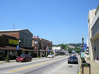
Ravenna is a home rule-class city in Estill County, Kentucky, United States. The population was 605 at the 2010 census.

<span class="mw-page-title-main">Cambridge, Kentucky</span> City in Kentucky, United States

Cambridge is a home rule-class city in Jefferson County, Kentucky, United States. The population was 175 at the 2010 census.

<span class="mw-page-title-main">Hyden, Kentucky</span> City in Kentucky, United States

Hyden is a home rule-class city in and the county seat of Leslie County, Kentucky, United States. The population was 365 at the 2010 census. It is located at the junction of U.S. Route 421 and Kentucky Route 80, along the Middle Fork of the Kentucky River.

<span class="mw-page-title-main">Calhoun, Kentucky</span> City in Kentucky, United States

Calhoun is a home rule-class city in McLean County, Kentucky, United States. The population was 725 at the 2020 census. It is the county seat of McLean County. It is included in the Owensboro, Kentucky Metropolitan Statistical Area.

<span class="mw-page-title-main">Camargo, Kentucky</span> City in Kentucky, United States

Camargo is a home rule-class city in Montgomery County, Kentucky, in the United States. The population was 1,020 at the 2020 census. It is part of the Mount Sterling Micropolitan Statistical Area.

<span class="mw-page-title-main">Jeffersonville, Kentucky</span> City in Kentucky, United States

Jeffersonville is a home rule-class city in Montgomery County, Kentucky, in the United States. The population was 1,708 as of the 2020 census, up from 1,506 in 2010. It is part of the Mount Sterling micropolitan area.

<span class="mw-page-title-main">Mount Sterling, Kentucky</span> City in Kentucky, United States

Mount Sterling, often written as Mt. Sterling, is a home rule-class city in Montgomery County, Kentucky, United States. The population was 7,558 as of the 2020 census, up from 6,895 in 2010. It is the county seat of Montgomery County and the principal city of the Mount Sterling micropolitan area.

<span class="mw-page-title-main">West Liberty, Kentucky</span> City in Kentucky, United States

West Liberty is a home rule-class city in Morgan County, Kentucky, United States. It is the county seat of Morgan County. As of the 2020 census, the city population was 3,215. It is located along the Licking River at the junction of Kentucky Route 7 and U.S. Route 460.

<span class="mw-page-title-main">Beaver Dam, Kentucky</span> City in Kentucky, United States

Beaver Dam is a home rule-class city in Ohio County, Kentucky, in the United States. The population was 3,409 at the 2010 census, and it is the most populous community in the county. It is named for the Beaver Dam Baptist Church which predates the town by several decades. The city was formally incorporated by the state assembly in 1873.

<span class="mw-page-title-main">Stanton, Kentucky</span> City in Kentucky, United States

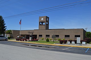
Stanton is a home rule-class city in and the county seat of Powell County, Kentucky, United States. The population was 3,251 in the 2020 census.

<span class="mw-page-title-main">Taylorsville, Kentucky</span> City in Kentucky, United States

Taylorsville is a home rule-class city in Spencer County, Kentucky, United States. It is the county seat of Spencer County. As of the 2020 census, the city had a total population of 1,256. It was incorporated in 1829.

Hollins is a census-designated place (CDP) in Botetourt and Roanoke County, Virginia, United States. Hollins covers much of the area known locally as "North County". The population was 15,574 at the 2020 census. It is part of the Roanoke Metropolitan Statistical Area. The area is also the home of Hollins University in addition to four properties listed on the National Register of Historic Places: the Black Horse Tavern-Bellvue Hotel and Office, Harshbarger House, the Hollins College Quadrangle, and Old Tombstone.

<span class="mw-page-title-main">Clay City, Kentucky</span> City in Kentucky, United States

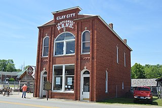
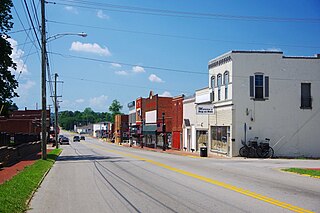
Clay City is a home rule-class city in Powell County, Kentucky, United States. The population was 1,077 at the 2010 census.

References

  1. 1 2 "2022 U.S. Gazetteer Files: Kentucky". United States Census Bureau. Retrieved May 17, 2023.
  2. 1 2 "P1. Race – Frenchburg city, Kentucky: 2020 DEC Redistricting Data (PL 94-171)". U.S. Census Bureau. Retrieved May 17, 2023.
  3. "Find a County". National Association of Counties. Archived from the original on May 31, 2011. Retrieved June 7, 2011.
  4. 1 2 Bryant, Ron D. (1992). "Frenchburg". In Kleber, John (ed.). Encyclopedia of Kentucky. p. 358. Retrieved on 2010-06-29
  5. Rennick, Robert M. (1987). Kentucky Place Names. University Press of Kentucky. p. 110. ISBN   0813126312 . Retrieved April 28, 2013.
  6. Gannett, Henry (1905). The Origin of Certain Place Names in the United States. Govt. Print. Off. p. 132.
  7. Commonwealth of Kentucky. Office of the Secretary of State. Land Office. "Frenchburg, Kentucky". Accessed 26 July 2013.
  8. "Frenchburg School Campus".
  9. "US Gazetteer files: 2010, 2000, and 1990". United States Census Bureau. February 12, 2011. Retrieved April 23, 2011.
  10. Climate Summary for Frenchburg, Kentucky
  11. "Census of Population and Housing". Census.gov. Retrieved June 4, 2015.
  12. "U.S. Census website". United States Census Bureau . Retrieved January 31, 2008.
  13. Kentucky Secretary of State - Land Office Retrieved on 2010-06-29
  14. "Kentucky Public Library Directory". Kentucky Department for Libraries and Archives. Archived from the original on January 11, 2019. Retrieved June 7, 2019.