Williamsburg, Kentucky

Last updated

Williamsburg, Kentucky
Williamsburg, Kentucky.jpg
Nickname(s): 
The 'Burg; Gateway to the Cumberlands
Motto: 
"Feels Like Home"
Whitley County Kentucky Incorporated and Unincorporated areas Williamsburg Highlighted 2183334.svg
Location of Williamsburg in Whitley County, Kentucky.
Coordinates: 36°44′22″N84°09′52″W / 36.73944°N 84.16444°W / 36.73944; -84.16444
Country United States
State Kentucky
County Whitley
EstablishedFebruary 5, 1819 (1819-02-05)
IncorporatedMarch 3, 1851 (1851-03-03) [1]
First meeting of city governmentJune 4, 1894 (1894-06-04) [2]
Government
  Mayor  Roddy Harrison
Area
[3]
  Total4.28 sq mi (11.08 km2)
  Land4.17 sq mi (10.80 km2)
  Water0.11 sq mi (0.28 km2)
Elevation
[4]
1,007 ft (307 m)
Population
 (2020)
  Total5,326
  Estimate 
(2022) [5]
5,163
  Density1,277.52/sq mi (493.21/km2)
Time zone UTC-5 (EST)
  Summer (DST) UTC-4 (EDT)
ZIP code
40769
Area code 606
FIPS code 21-83334
GNIS feature ID2405747 [4]
Website http://www.williamsburgky.com/

Williamsburg is a home rule-class city in and the county seat of Whitley County, on the southeastern border of Kentucky, United States. [6] The population was 5,326 at the 2020 census. Developed along the Cumberland River, the city was founded in 1818 and named after William Whitley.

Contents

History

Williamsburg was first known by early European-American settlers as the Spring Ford, after a nearby ford crossing the Cumberland River. On April 19, 1818, the first meeting of the Whitley County Court was held at Samuel Cox's dwelling. [7] This first court appointed local officials as well as constables to work with the county militia. The town was known simply as Whitley Courthouse. In 1882 the city was renamed as Williamsburgh, and the spelling was changed in 1890 to the current Williamsburg.

The town's initial growth was fueled by three freshwater springs in the area. Settlers were attracted to this water source. They later developed coal mining and lumber industries, based on natural resources of the area.

Construction of the Louisville and Nashville Railroad (L&N) to the town in 1883 stimulated new growth. It connected the town to far-flung markets and attracted new residents and trade. Shortly thereafter in 1886 the town elected W. H. Parker as its first mayor. [8]

This first city government enacted a number of new ordinances including:

The Williamsburg school system was established in 1909; the town residents voted to consolidate the multiple single-room schools in the area into a unified school district. [9] The first consolidated school building was destroyed by fire in 1926. It was rebuilt for the school administration. Later the structure was adapted as the Anderson Building, which is used in the early 21st century by the University of the Cumberlands. The school district moved to its current location in 1983.

The county courthouse was destroyed by fire in 1931. It was rebuilt at the time. Forty years later, it underwent a major renovation to bring it up to standards of 1971. In 2011 the newly constructed Whitley County Judicial Center was completed adjacent to the old courthouse, and the courts moved to the new building. [7] [10]

Geography

Williamsburg is located within the Eastern Mountain Coal Fields and the Appalachian Plateau regions. The oldest parts of the city lie in a bend of the Cumberland River just downstream of where the Clear Fork flows into it east of the city. The University of the Cumberlands occupies the heights within the river bend. The I-75 corridor runs past the west side of the city with exits 11 and 15 providing access. I-75 leads north 103 mi (166 km) to Lexington and south 70 mi (113 km) to Knoxville, Tennessee. U.S. Route 25W runs to the east of downtown from south to north, leading north 21 mi (34 km) to Corbin and south 13 mi (21 km) to Jellico, Tennessee. Kentucky Route 92 runs through the city from west to east, leading east 35 mi (56 km) to Fourmile and west 20 mi (32 km) to Pine Knot. The city has a single active rail line running north to south, with a single branch that goes east to the Gatliff Mine.

According to the United States Census Bureau, the city has a total area of 4.8 square miles (12 km2), of which 4.7 square miles (12 km2) is land and 0.1 square miles (0.26 km2) (2.10%) is water.

Percent of U.S. within 600 miles (970 km) of Williamsburg: [11]

Points of interest

Williamsburg is home to the Kentucky Splash Waterpark (located within the Hal Rogers Family Entertainment Center). The $5 million facility also houses a go-cart course, a miniature golf course, and a five-station batting cage. The park opened on Memorial Day weekend 2001 and is the largest family entertainment center in Kentucky with a capacity of up to 3,000 guests. [12]

Williamsburg is located 18 miles (29 km) away Cumberland Falls State Resort Park within the Daniel Boone National Forest. The park is the home of Cumberland Falls, sometimes called the Little Niagara, the Niagara of the South or the Great Falls and is the only venue in the Western Hemisphere where a moonbow or lunar rainbow is regularly visible on a clear night with a full moon. [13] On average the falls, which flow over a resistant sandstone bed, are 68 feet (21 m) high and 125 feet (38 m) wide, with an average water flow of 3,600 cubic feet (100 m3) per second (100 m³/s).Trails winding downstream from the park on either side of the river lead to the smaller Angel Falls and Dog Slaughter Falls. Angel Falls is located 1.5 miles (2.4 km) from the park on the McCreary County side and Dog Slaughter Falls is located 3.5 miles (5.6 km) from the park on the Whitley County side. The Below the Falls section of the river includes a five-mile (8 km) long class 2–3 run that is ideal for families and beginner stage white water rafters and kayakers.

Williamsburg is located 20 minutes away from the Big South Fork of the Cumberland River, a major tributary of the Cumberland River system and a class 3–4 whitewater canoeing and kayaking stream. The Big South Fork is also home to Yahoo Falls, which stand 113 feet (34.8 m) high. Further along, the trail leads to the Yahoo Arch.

Williamsburg is also home to one of the top bluegrass festivals in the state of Kentucky (the Sally Gap Bluegrass Festival). Other events are the Jeep Jamboree (an off-road sporting event), and the Border Bowl, an annual event for two teams of high school footballers representing Kentucky and Tennessee.

Religion

As of the 2000 census Whitley County, Kentucky of which Williamsburg is the county seat consisted of 22,645 Evangelical Christians, 1,741 Mainline Christians, 130 Catholics, and 11,394 individuals who are not members of the 188 groups included in the Churches & Church Membership Data. As of the same date 69.4% of individuals in Whitley County were members of the Southern Baptist Convention. [14] Williamsburg boasts 21 religious institutions or one religious institution per 243 citizens, and as of the year 2000 the region that contains the town has been designated the second densest region of the bible belt. [15] University of the Cumberlands, located in the town, is a private Christian college affiliated with the Kentucky Baptist Convention, a member of the Southern Baptist Convention.

Economy

Top Employers: [11]

  1. Firestone Industrial Products
  2. Whitley County School System
  3. Williamsburg Plastics
  4. University of The Cumberlands
  5. Southeastern Kentucky Rehabilitation Industries (SEKRI)
  6. Computer Sciences Corporation (CSC)
  7. Walmart
  8. Kentucky Consular Center

Demographics

Historical population
CensusPop.Note
1860 126
1870 13910.3%
1880 20849.6%
1890 1,376561.5%
1900 1,4958.6%
1910 2,00434.0%
1920 1,767−11.8%
1930 1,8263.3%
1940 2,33127.7%
1950 3,34843.6%
1960 3,4783.9%
1970 3,6876.0%
1980 5,56050.8%
1990 5,493−1.2%
2000 5,143−6.4%
2010 5,2452.0%
2020 5,3261.5%
2022 (est.)5,163 [16] −3.1%
U.S. Decennial Census [17]

As of the census [18] of 2000, there were 5,143 people, 1,928 households, and 1,127 families residing in the city. The population density was 1,102.5 inhabitants per square mile (425.7/km2). There were 2,118 housing units at an average density of 454.0 per square mile (175.3/km2). The racial makeup of the city was 96.46% White, 1.73% African American, 0.21% Native American, 0.35% Asian, 0.02% Pacific Islander, 0.12% from other races, and 1.11% from two or more races. Hispanic or Latino of any race were 0.66% of the population.

There were 1,928 households, out of which 26.5% had children under the age of 18 living with them, 38.9% were married couples living together, 16.9% had a female householder with no husband present, and 41.5% were non-families. 35.6% of all households were made up of individuals, and 14.6% had someone living alone who was 65 years of age or older. The average household size was 2.20 and the average family size was 2.87.

In the city, the population was spread out, with 19.5% under the age of 18, 24.9% from 18 to 24, 22.2% from 25 to 44, 18.4% from 45 to 64, and 15.0% who were 65 years of age or older. The median age was 30 years. For every 100 females, there were 85.1 males. For every 100 females age 18 and over, there were 80.2 males.

The median income for a household in the city was $18,114, and the median income for a family was $25,996. Males had a median income of $31,905 versus $17,339 for females. The per capita income for the city was $11,224. About 29.3% of the population and 35.4% of the population were below the poverty line, including 49.0% of those under the age of 18 and 15.1% of those ages 65 and older.

Education

K-12

Two public school districts serve the city:

In addition, Corbin Education Center serves as an alternative school for students in the Corbin, Williamsburg, and Whitley County school districts. [19]

Colleges and universities

University of the Cumberlands marker off of Main Street, in Williamsburg, Kentucky University of the Cumberlands Welcome Sign.JPG
University of the Cumberlands marker off of Main Street, in Williamsburg, Kentucky

The campus of the University of the Cumberlands (formerly Cumberland College) is located on College Hill adjacent to the downtown area of Williamsburg. UC is a private liberal arts college, with an enrollment of approximately 2,200 students. Its sports teams participate in the NAIA. The school is affiliated with the Kentucky Baptist Convention (the Kentucky affiliate of the Southern Baptist Convention).

Library

Williamsburg has a lending library, the Whitley County Public Library. [20]

Media

Newspapers

Radio

Notable people

Climate

The climate in this area is characterized by hot, humid summers and generally mild to cool winters. According to the Köppen Climate Classification system, Williamsburg has a humid subtropical climate, abbreviated "Cfa" on climate maps. [21]

Related Research Articles

<span class="mw-page-title-main">Whitley County, Kentucky</span> County in Kentucky, United States

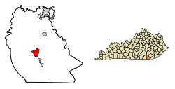
Whitley County is a county located in the southeastern part of the U.S. state of Kentucky. As of the 2020 census, the population was 36,712. Its county seat is at Williamsburg, though the largest city is Corbin, and the county's District Court sits in both cities. Whitley County is included in the London, KY Micropolitan Statistical Area.

<span class="mw-page-title-main">McCreary County, Kentucky</span> County in Kentucky, United States

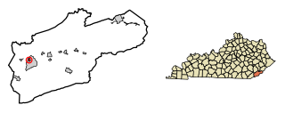
McCreary County is a county located in the U.S. state of Kentucky. As of the 2020 census, the population was 16,888. Its county seat is Whitley City. The county is named for James B. McCreary, a Confederate war soldier and two-time Governor of Kentucky. During his second term as governor, McCreary County was created by the Legislature and was named in his honor.

<span class="mw-page-title-main">Pineville, Kentucky</span> City in Kentucky, United States

Pineville is a home rule-class city in Bell County, Kentucky, United States. It is the seat of its county. The population was 1,732 as of the 2010 census. It is located on a small strip of land between the Cumberland River and Pine Mountain.

<span class="mw-page-title-main">Burkesville, Kentucky</span> City in Kentucky, United States

Burkesville is a home rule-class city in Cumberland County, Kentucky, in the United States. Nestled among the rolling foothills of Appalachia and bordered by the Cumberland River to the south and east, it is the seat of its county. The population was 1,521 at the 2010 census.

<span class="mw-page-title-main">Sandy Hook, Kentucky</span> City in Kentucky, United States

Sandy Hook is a home rule-class city beside the Little Sandy River in Elliott County, Kentucky, in the United States. The population was 675 at the 2010 census.

<span class="mw-page-title-main">Cumberland, Kentucky</span> City in Kentucky, United States

Cumberland is a home rule-class city in Harlan County, Kentucky, in the United States. The population according to the 2010 Census was 2,237, down from 2,611 at the 2000 census. The city sits at the confluence of Looney Creek and the Poor Fork Cumberland River.

<span class="mw-page-title-main">Harlan, Kentucky</span> City in Kentucky, United States

Harlan is a home rule-class city in and the county seat of Harlan County, Kentucky, United States. The population was 1,745 at the 2010 census, down from 2,081 at the 2000 census.

<span class="mw-page-title-main">Wallins Creek, Kentucky</span> Census-designated place in Kentucky, United States

Wallins Creek is an unincorporated community and census-designated place (CDP) in Harlan County, Kentucky, United States. The population was 156 at the 2010 census, when it was still a city, having dropped from 257 at the 2000 census.

<span class="mw-page-title-main">Beattyville, Kentucky</span> City in Kentucky, United States

Beattyville is a home rule class city in, and the county seat of, Lee County, Kentucky, United States. The city was formally established by the state assembly as "Beatty" in 1851 and incorporated in 1872. It was named for Samuel Beatty, a pioneer settler. The population was 1,307 at the 2010 census and an estimated 1,206 in 2018.

<span class="mw-page-title-main">Vanceburg, Kentucky</span> City in Kentucky, United States

Vanceburg is a home rule-class city in Lewis County, Kentucky, United States, along the Ohio River. The population was 1,428 at the 2020 census. It is the county seat of Lewis County.

<span class="mw-page-title-main">Kuttawa, Kentucky</span> City in Kentucky, United States

Kuttawa is a home rule-class city in Lyon County, Kentucky, in the United States. The population was 649 as of the 2010 census, up from 596 in 2000.

<span class="mw-page-title-main">Berea, Kentucky</span> City in Kentucky, United States

Berea is a home rule-class city in Madison County, Kentucky, in the United States. The town is best known for its art festivals, historic restaurants and buildings, and as the home to Berea College, a private liberal arts college. The population was 15,539 at the 2020 census. It is one of the fastest-growing towns in Kentucky, having increased by 27.4% since 2000. Berea is a principal city of the Richmond−Berea Micropolitan Statistical Area, which includes Madison and Rockcastle counties. It was formally incorporated by the state assembly in 1890.

<span class="mw-page-title-main">Pine Knot, Kentucky</span> Census-designated place in Kentucky, United States

Pine Knot is an unincorporated community and census-designated place (CDP) in McCreary County, Kentucky, United States. The population was 1,380 at the 2020 census, down from 1,621 in 2010.

<span class="mw-page-title-main">Stearns, Kentucky</span> Census-designated place in Kentucky, United States

Stearns is an unincorporated community and census-designated place (CDP) in McCreary County, Kentucky, United States. The population was 1,365 at the 2020 census. It was founded by Justus Smith Stearns.

<span class="mw-page-title-main">Whitley City, Kentucky</span> Census-designated place in Kentucky, United States

Whitley City is an unincorporated community and census-designated place (CDP) in McCreary County, Kentucky, United States. The population was 968 at the 2020 census, down from 1,170 in 2010. It is the county seat of McCreary County. Whitley City is one of two unincorporated county seats in Kentucky.

<span class="mw-page-title-main">Calhoun, Kentucky</span> City in Kentucky, United States

Calhoun is a home rule-class city in McLean County, Kentucky, United States. The population was 725 at the 2020 census. It is the county seat of McLean County. It is included in the Owensboro, Kentucky Metropolitan Statistical Area.

<span class="mw-page-title-main">Gamaliel, Kentucky</span> City in Kentucky, United States

Gamaliel is a home rule-class city in Monroe County, Kentucky, in the United States. The population was 391 at the 2020 census.

<span class="mw-page-title-main">Mount Sterling, Kentucky</span> City in Kentucky, United States

Mount Sterling, often written as Mt. Sterling, is a home rule-class city in Montgomery County, Kentucky, United States. The population was 7,558 as of the 2020 census, up from 6,895 in 2010. It is the county seat of Montgomery County and the principal city of the Mount Sterling micropolitan area.

<span class="mw-page-title-main">Corbin, Kentucky</span> City in Kentucky, United States

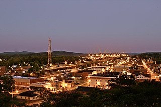
Corbin is a home rule-class city in Whitley, Knox and Laurel counties in the southeastern portion of the U.S. state of Kentucky. As of the 2020 census, the city population was 7,856.

<span class="mw-page-title-main">North Corbin, Kentucky</span> Census-designated place in Kentucky, United States

North Corbin is a census-designated place (CDP) in Laurel and Knox counties in the U.S. state of Kentucky. The population was 1,727 at the 2020 census down from 1,773 at the 2010 census. The census bureau also lists the Laurel County portion of North Corbin as a CCD with a population of 10,729.

References

  1. Kentucky Secretary of State-Land Office Retrieved on June 19, 2010
  2. History of Williamsburg Retrieved on June 19, 2010
  3. "2020 U.S. Gazetteer Files". United States Census Bureau. Retrieved March 18, 2022.
  4. 1 2 U.S. Geological Survey Geographic Names Information System: Williamsburg, Kentucky
  5. "Annual Estimates of the Resident Population for Incorporated Places in Kentucky: April 1, 2020 to July 1, 2022". United States Census Bureau. Retrieved May 26, 2023.
  6. "Find a County". National Association of Counties. Retrieved June 7, 2011.
  7. 1 2 "History of Whitley County".
  8. "History of Williamsburg City Government".
  9. "History of Williamsburg City School".
  10. "Judicial Center Construction".
  11. 1 2 "Williamsburg, KY Quick Facts" . Retrieved March 23, 2018.
  12. "Kentucky Splash Waterpark". williamsburgky. October 3, 2021. Retrieved October 3, 2021.
  13. "Kentucky Splash Waterpark".
  14. "The Association of Religion Data Archives – Maps & Reports".
  15. "Williamsburg, KY – Religious History" . Retrieved March 23, 2018.
  16. "Annual Estimates of the Resident Population for Incorporated Places in Kentucky: April 1, 2020 to July 1, 2022". United States Census Bureau. Retrieved May 26, 2023.
  17. "Census of Population and Housing". Census.gov. Retrieved June 4, 2015.
  18. "U.S. Census website". United States Census Bureau . Retrieved January 31, 2008.
  19. "Former utilities building to serve new purpose". The Times-Tribune.com.
  20. "Kentucky Public Library Directory". Kentucky Department for Libraries and Archives. Archived from the original on January 11, 2019. Retrieved June 7, 2019.
  21. "Williamsburg, Kentucky Köppen Climate Classification (Weatherbase)". Weatherbase.