Fort Snelling (unorganized territory), Minnesota

Last updated
Unorganized Territory of Fort Snelling
Unorganized territory
MSP-airport-aerial-2006-11-08.jpg
Aerial photograph of Minneapolis–St. Paul International Airport showing much of the unorganized territory of Fort Snelling. The historic fort is by the confluence of the Mississippi and Minnesota toward the upper right of the photograph, and Fort Snelling National Cemetery is at center right.
USA Minnesota location map.svg
Red pog.svg
Unorganized Territory of Fort Snelling
Location within the state of Minnesota
Coordinates: 44°53′34″N93°10′50″W / 44.89278°N 93.18056°W / 44.89278; -93.18056
CountryUnited States
State Minnesota
County Hennepin County
Elevation
860 ft (260 m)
Population
 (2020)
  Total322
Time zone UTC-6 (Central (CST))
  Summer (DST) UTC-5 (CDT)

Fort Snelling is an unorganized territory of Hennepin County in the U.S. state of Minnesota. It is named after historic Fort Snelling, which is located within its boundaries. [1] The district also includes Coldwater Spring park, Minneapolis-Saint Paul International Airport, parts of the Mississippi National River and Recreation Area, and several government facilities. As of the 2020 census the territory had a population of 322 people.

Contents

Geography

View of the Round Tower. The flag is at half-staff because former American President Ronald Reagan had died just prior to the day the photograph was taken. Fort Snelling Round Tower large.jpg
View of the Round Tower. The flag is at half-staff because former American President Ronald Reagan had died just prior to the day the photograph was taken.

The unorganized territory of Fort Snelling is just east of the city of Richfield. Historic Fort Snelling is located at the eastern end of the territory, near the confluence of the Mississippi River with the Minnesota River. It also borders Minneapolis to the north and Bloomington to the southwest, while Saint Paul in Ramsey County (including Pike Island) is to the northeast, and across the Minnesota River are Mendota and Mendota Heights in Dakota County.

For postal purposes, addresses in the eastern portion of the unorganized territory (including Terminal 1 of the Minneapolis St. Paul International Airport and the Fort Snelling historic site) are in zip code 55111 with a Saint Paul mailing address, while addresses in the western part of the territory (including the airport's Terminal 2 and the Metropolitan Airports Commission offices) are in zip code 55450 and have a Minneapolis mailing address. [2] According to the United States Census Bureau, this unorganized territory has a total area of 17.2 km2 (6.7 mi2). 16.5 km2 (6.4 mi2) of it is land and 0.8 km2 (0.3 mi2) of it is water.

Fort Snelling's territory contains numerous military and other federal facilities. These facilities include the current National Guard base at Fort Snelling, Fort Snelling National Cemetery, and the Minneapolis Veterans Health Administration Medical Center.

Several facilities belonging to Minnesota state government agencies such as the Minnesota Department of Transportation are also located in the territory, as are the headquarters and portions of Fort Snelling State Park and the Minnesota Valley National Wildlife Refuge.

Minneapolis–Saint Paul International Airport, however, includes most of the land area of the unorganized territory. Delta Air Lines Building C is located on the airport property and in Fort Snelling, [3] [4] [5] [6] and is used by the airline for northern and regional operations. [7]

Demographics

Historical population
CensusPop.Note
1880 352
1890 55056.3%
1930 2,043
1940 2,97245.5%
1950 2,584−13.1%
1960 898−65.2%
1970 624−30.5%
1980 223−64.3%
1990 97−56.5%
2000 442355.7%
2010 149−66.3%
2020 322116.1%
U.S. Decennial Census [8]

Fort Snelling was listed as an incorporated village during the 1890 Census. [8]

In the era after World War II, residents of the unorganized territory were service members stationed at the barracks at Fort Snelling, and military families living on base housing in the Upper Post area. Over time, some parts of the fort were demolished to expand Minneapolis–Saint Paul International Airport, and the Upper Post was abandoned as housing in 1973 with ownership transferred to the Minnesota Department of Natural Resources. [9] In the 2010s, private housing started to be developed in the Upper Post. This began with a newly built apartment complex that opened in 2015, followed by a redevelopment of all the remaining Upper Post buildings that was completed in 2022. All of this new housing is intended primarily for veterans and their families, with funding provided by federal, state, and local historical preservation and affordable housing funds. [10] [11] [12] [13]

As of the census [14] of 2020, 322 people resided in 239 households in the unorganized territory. 83.5% of households spoke English at home and 14.6% spoke Spanish. The median household income was $18,594. 31.1% of the population was below the poverty line.

Related Research Articles

<span class="mw-page-title-main">Saint Paul, Minnesota</span> Capital city of Minnesota, United States

Saint Paul is the capital of the U.S. state of Minnesota and the county seat of Ramsey County. Situated on high bluffs overlooking a bend in the Mississippi River, Saint Paul is a regional business hub and the center of Minnesota's government. The Minnesota State Capitol and the state government offices all sit on a hill close to the city's downtown district. One of the oldest cities in Minnesota, Saint Paul has several historic neighborhoods and landmarks, such as the Summit Avenue Neighborhood, the James J. Hill House, and the Cathedral of Saint Paul. Like the adjacent city of Minneapolis, Saint Paul is known for its cold, snowy winters and humid summers.

<span class="mw-page-title-main">Ramsey County, Minnesota</span> County in Minnesota, United States

Ramsey County is a county located in the U.S. state of Minnesota. As of the 2020 census, the population was 552,352, making it the second-most populous county in Minnesota. Its county seat and largest city is Saint Paul, the state capital and the twin city of Minneapolis. The county was founded in 1849 and is named for Alexander Ramsey, the first governor of the Minnesota Territory.

<span class="mw-page-title-main">Hennepin County, Minnesota</span> County in Minnesota, United States

Hennepin County is a county in the U.S. state of Minnesota. Its county seat is Minneapolis, the state's most populous city. The county is named for the 17th-century explorer Louis Hennepin. It extends from Minneapolis to the suburbs and outlying cities in the western part of the county. Its natural areas are covered by extensive woods, hills, and lakes.

<span class="mw-page-title-main">Dakota County, Minnesota</span> County in Minnesota, United States

Dakota County is the third-most populous county in the U.S. state of Minnesota, located in the east central portion of the state. As of the 2020 census, the population was 439,882. The population of Dakota County was estimated to be 447,440 in 2023. The county seat is Hastings. Dakota County is named for the Dakota Sioux tribal bands who inhabited the area.

<span class="mw-page-title-main">Minneapolis–Saint Paul</span> Metropolitan area in Minnesota, United States

Minneapolis–Saint Paul is a metropolitan area in the Upper Midwestern United States centered around the confluence of the Mississippi, Minnesota and St. Croix rivers in the U.S. state of Minnesota. It is commonly known as the Twin Cities after the area's two largest cities, Minneapolis and Saint Paul. Minnesotans often refer to the two together simply as "the cities". The area is Minnesota's economic, cultural, and political center.

<span class="mw-page-title-main">Richfield, Minnesota</span> City in Minnesota, United States

Richfield is a city in Hennepin County, Minnesota. An inner-ring suburb of Minneapolis, Richfield is bordered by Minneapolis to the north, Minneapolis–Saint Paul International Airport and Fort Snelling to the east, Bloomington to the south, and Edina to the west. The population was 36,994 at the 2020 census.

<span class="mw-page-title-main">Fort Snelling</span> Historic fort in Minnesota, US

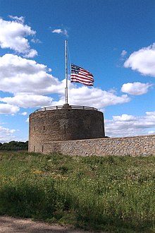
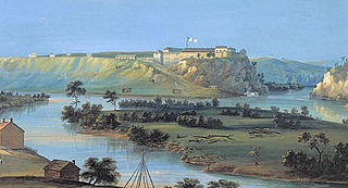
Fort Snelling is a former military fortification and National Historic Landmark in the U.S. state of Minnesota on the bluffs overlooking the confluence of the Minnesota and Mississippi Rivers. The military site was initially named Fort Saint Anthony, but it was renamed Fort Snelling once its construction was completed in 1825.

<span class="mw-page-title-main">Minneapolis–Saint Paul International Airport</span> Airport in Minnesota, United States

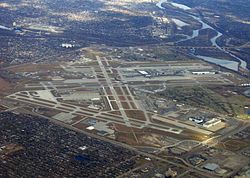
Minneapolis–Saint Paul International Airport, also less commonly known as Wold–Chamberlain Field, is a joint civil-military public international airport serving the Twin Cities in the U.S. state of Minnesota. It is located in Fort Snelling Unorganized Territory. Although situated within the unorganized territory, the airport is centrally located within 10 miles of both downtown Minneapolis and downtown Saint Paul. In addition to primarily hosting commercial flights from major American and some international airlines, the airport is also home to several United States Air Force and Minnesota Air National Guard operations. The airport is also used by a variety of air cargo operators. MSP is the busiest airport in the Upper Midwest.

<span class="mw-page-title-main">Minnesota Territory</span> United States territory from 1849 to 1858, part of which became the state of Minnesota

The Territory of Minnesota was an organized incorporated territory of the United States that existed from March 3, 1849, until May 11, 1858, when the eastern portion of the territory was admitted to the Union as the State of Minnesota and the western portion became unorganized territory and shortly after was reorganized as part of the Dakota Territory.

<span class="mw-page-title-main">History of Minnesota</span> History of the US state

The history of the U.S. state of Minnesota is shaped by its original Native American residents, European exploration and settlement, and the emergence of industries made possible by the state's natural resources. Early economic growth was based on fur trading, logging, milling and farming, and later through railroads and iron mining.

<span class="mw-page-title-main">Minnesota State Highway 5</span> Highway in Minnesota

Minnesota State Highway 5 is a 76.347-mile-long (122.869 km) highway in Minnesota, which runs from its intersection with MN 19 and MN 22 in Gaylord and continues east and northeast to its eastern terminus at its intersection with MN 120 in Maplewood. The route passes through downtown Saint Paul.

<span class="mw-page-title-main">Mendota Bridge</span> Bridge in Mendota Heights and Fort Snelling, Minnesota

The Mendota Bridge, in the US state of Minnesota carries State Highway 55 (MN 55) and MN 62 over the Minnesota River between Fort Snelling and Mendota Heights. It is the final bridge over the Minnesota River before the Minnesota flows into the Mississippi River at the "Meeting of the waters" or "Mendota" in the Dakota language. Traffic on the north end of the bridge may turn onto the Fort Road Bridge (MN 5) to cross the Mississippi River into Saint Paul, Minnesota. The skylines of both Minneapolis and Saint Paul can be seen simultaneously from the bridge.

<span class="mw-page-title-main">Compass Airlines (North America)</span> Defunct regional airline of the United States (2006–2020)

Compass Airlines, LLC, was a regional airline in the United States that operated from 2006 to 2020, when it shut down due to the COVID-19 pandemic. It was headquartered in Delta Air Lines Building C at Minneapolis–Saint Paul International Airport in Fort Snelling, Hennepin County, Minnesota; prior to December 16, 2009, it was headquartered in unincorporated Fairfax County, Virginia, United States, east of the Chantilly CDP. The airline launched inaugural service with a single Bombardier CRJ-200 aircraft under the Northwest Airlink brand between Minneapolis/St. Paul and Washington, D.C., on May 2, 2007. On August 21, 2007, it began flying two Embraer E175 76-passenger aircraft, and expanded to 36 aircraft by December 2008.

<span class="mw-page-title-main">Fort Snelling National Cemetery</span> Veterans cemetery in Hennepin County, Minnesota

Fort Snelling National Cemetery is a United States National Cemetery located in the Fort Snelling Unorganized Territory adjacent to the historic fort and Minneapolis–Saint Paul International Airport. It is the only National Cemetery in Minnesota. Administered by the United States Department of Veterans Affairs, it covers 436.3 acres (176.6 ha), and as of August, 2023 had over 256,000 interments. It was listed on the National Register of Historic Places in 2016.

<span class="mw-page-title-main">Big Rivers Regional Trail</span>

Big Rivers Regional Trail is a paved 4.5-mile (7.2 km) rail trail that overlooks the confluence of the Minnesota and Mississippi rivers along the northern edge of Dakota County, Minnesota, United States. It runs between the cities of Eagan and Lilydale.

Republic Airlines was an airline in the United States that operated from 1979 until it merged with Northwest Airlines in 1986. Republic was formed by the merger of North Central Airlines and Southern Airways on July 1, 1979. Their headquarters were at Minneapolis–Saint Paul International Airport, in what is now Fort Snelling in unincorporated Hennepin County, Minnesota. The former headquarters is now Delta Air Lines Building C.

<span class="mw-page-title-main">Minnesota State Highway 62 (Hennepin–Dakota counties)</span> Eastern highway in Minnesota

Minnesota State Highway 62 (MN 62) is a highway in the Twin Cities region of Minnesota. The route was part of County Road 62 (CR 62) until 1988, when a portion of the route was inherited by the state. The western terminus of the highway is at Interstate 494 (I-494) in Eden Prairie, where the roadway continues west as CR 62 to CR 101. The eastern terminus of the route is at the junction with I-494 in Inver Grove Heights. Locally, the original portion of the route in Hennepin County is known as "the Crosstown Highway" or simply "the Crosstown," though signage with this name does not appear on the highway itself, but only on local streets adjacent to the road. It is also used as an alternate name, even by the Minnesota Department of Transportation (MnDOT). The route is 18.6 miles (29.9 km) in length.

<span class="mw-page-title-main">Minneapolis–Saint Paul Joint Air Reserve Station</span> United States Air Force base

Minneapolis–Saint Paul Joint Air Reserve Station is a United States Air Force base, located at Minneapolis–Saint Paul International Airport. It is located in the Fort Snelling Unorganized Territory on the southeast border of Minneapolis, Minnesota. It was formerly the location of Naval Air Station Twin Cities.

<span class="mw-page-title-main">Outline of Minnesota</span> Overview of and topical guide to Minnesota

The following outline is provided as an overview of and topical guide to the U.S. state of Minnesota:

<span class="mw-page-title-main">Territorial era of Minnesota</span> Period in Minnesota history, 1803–1858

The territorial era of Minnesota lasted from the Louisiana Purchase in 1803 to Minnesota's achieving statehood in 1858. The Minnesota Territory itself was formed only in 1849 but the area had a rich history well before this. Though there was a long history of European presence in the area before 19th century, it was during the 19th century that the United States began to establish a firm presence in what would become Minnesota.

References

  1. "Unorganized Territory Of Fort Snelling MN Demographic Data and Boundary Map". minnesota.hometownlocator.com. Retrieved 2020-11-02.
  2. "Minnesota Zip Code Boundary Map (MN)". www.zipmap.net. Retrieved 2018-03-04.
  3. "delta air lines' farmers market-building c". Minneapolis–Saint Paul International Airport. Retrieved on January 19, 2012. "Location: MSP Airport-Delta Building C, North Side near Compass Airlines Entrance"
  4. "Fort Snelling UT, Hennepin county, Minnesota [ permanent dead link ]". (Archive [ dead link ]) U.S. Census Bureau. Retrieved on December 19, 2009.
  5. "Expanded Branch and ATM Access Comes to the Twin Cities Archived 2012-03-18 at the Wayback Machine ". Wings Financial. Retrieved on January 19, 2012. "Delta Air Lines Bldg. C* 7500 Airline Drive Minneapolis, MN"
  6. "Blood Drive | Delta Air Lines Bldg C Archived 2013-06-17 at the Wayback Machine ". Memorial Blood Centers. Retrieved on January 19, 2012. "Street: 7500 Airline Drive City: Bloomington State: Minnesota Country: USA"
  7. Niemela, Jennifer. "Delta reaches deal on Minnesota jobs". Minneapolis / St. Paul Business Journal . Tuesday December 16, 2008. Retrieved on January 19, 2012.
  8. 1 2 United States Census Bureau. "Census of Population and Housing" . Retrieved July 23, 2014.
  9. Watson, Catherine (2017). "Fort Snelling as I Knew It". Open Rivers: Rethinking Water, Place & Community. No. 7. doi:10.24926/2471190X.3189.
  10. "Fort Snelling project secures affordable housing financing while costing $900,000 per unit to build". 21 October 2020.
  11. Jones, Justine (January 5, 2023). "Historic Fort Snelling Buildings Get Revamped for Affordable Veteran Housing". Mpls St Paul.
  12. "New Affordable-Housing Community for Homeless Veterans Now Open at Fort Snelling" (Press release). BusinessWire. October 2, 2015.
  13. "Historic Fort Snelling Upper Post Gains New Life as Affordable Housing for Veterans" (Press release). Globe Newswire. November 14, 2022.
  14. "U.S. Census website". United States Census Bureau . Retrieved 2021-09-03.