O'Neill, Nebraska

Last updated

O'Neill, Nebraska
O'Neill, Nebraska pavement shamrock 1.JPG
Shamrock painted on pavement at 4th and Douglas
Holt County Nebraska Incorporated and Unincorporated areas O'Neill Highlighted.svg
Location of O'Neill, Nebraska
Coordinates: 42°27′40″N98°38′47″W / 42.46111°N 98.64639°W / 42.46111; -98.64639
Country United States
State Nebraska
County Holt
Incorporated1882 [1]
Area
[2]
  Total2.38 sq mi (6.18 km2)
  Land2.38 sq mi (6.18 km2)
  Water0.00 sq mi (0.00 km2)
Elevation
[3]
2,001 ft (610 m)
Population
 (2020)
  Total3,581
  Density1,501.47/sq mi (579.61/km2)
Time zone UTC-6 (Central (CST))
  Summer (DST) UTC-5 (CDT)
ZIP code
68763
Area code 402
FIPS code 31-37105
GNIS feature ID838176 [3]
Website cityofoneillnebraska.com

O'Neill is a city in Holt County, Nebraska, United States. The population was 3,705 at the 2010 census. It is the county seat of Holt County. [4]

Contents

History

O'Neill was platted in 1874. [5] It was named for one of its founders, John O'Neill. [6] O'Neill was originally settled largely by Irish immigrants. [7]

The town was incorporated in 1882. [1]

Geography

According to the United States Census Bureau, the city has a total area of 2.38 square miles (6.16 km2), all land. [8]

O'Neill is the official Irish capital of Nebraska. [9] Cattle, potatoes, tomatoes, soybeans and corn are the major products produced near this town.[ citation needed ]

Climate

Climate data for O'Neill, Nebraska (1991–2020 normals, extremes 1896–present)
MonthJanFebMarAprMayJunJulAugSepOctNovDecYear
Record high °F (°C)72
(22)
77
(25)
91
(33)
96
(36)
107
(42)
108
(42)
112
(44)
110
(43)
107
(42)
96
(36)
82
(28)
76
(24)
112
(44)
Mean maximum °F (°C)57.0
(13.9)
61.7
(16.5)
74.6
(23.7)
83.3
(28.5)
90.1
(32.3)
95.6
(35.3)
100.6
(38.1)
98.6
(37.0)
94.0
(34.4)
85.1
(29.5)
72.6
(22.6)
58.1
(14.5)
101.7
(38.7)
Mean daily maximum °F (°C)31.9
(−0.1)
35.8
(2.1)
47.4
(8.6)
58.1
(14.5)
69.7
(20.9)
81.1
(27.3)
87.3
(30.7)
84.7
(29.3)
76.7
(24.8)
61.5
(16.4)
46.6
(8.1)
34.3
(1.3)
59.6
(15.3)
Daily mean °F (°C)21.5
(−5.8)
24.7
(−4.1)
35.4
(1.9)
46.0
(7.8)
57.7
(14.3)
68.9
(20.5)
74.6
(23.7)
72.1
(22.3)
63.2
(17.3)
48.8
(9.3)
35.0
(1.7)
24.4
(−4.2)
47.7
(8.7)
Mean daily minimum °F (°C)11.0
(−11.7)
13.7
(−10.2)
23.4
(−4.8)
33.9
(1.1)
45.7
(7.6)
56.7
(13.7)
61.8
(16.6)
59.4
(15.2)
49.6
(9.8)
36.1
(2.3)
23.5
(−4.7)
14.5
(−9.7)
35.8
(2.1)
Mean minimum °F (°C)−10.1
(−23.4)
−6.3
(−21.3)
2.7
(−16.3)
19.2
(−7.1)
31.9
(−0.1)
45.0
(7.2)
50.8
(10.4)
48.5
(9.2)
34.3
(1.3)
19.3
(−7.1)
5.4
(−14.8)
−5.4
(−20.8)
−14.4
(−25.8)
Record low °F (°C)−30
(−34)
−34
(−37)
−34
(−37)
−5
(−21)
15
(−9)
34
(1)
39
(4)
37
(3)
19
(−7)
2
(−17)
−19
(−28)
−32
(−36)
−34
(−37)
Average precipitation inches (mm)0.46
(12)
0.67
(17)
1.51
(38)
2.92
(74)
4.21
(107)
3.48
(88)
3.26
(83)
3.09
(78)
2.35
(60)
2.30
(58)
0.89
(23)
0.71
(18)
25.85
(657)
Average snowfall inches (cm)4.1
(10)
5.8
(15)
4.7
(12)
1.7
(4.3)
0.4
(1.0)
0.0
(0.0)
0.0
(0.0)
0.0
(0.0)
0.0
(0.0)
0.9
(2.3)
2.7
(6.9)
5.3
(13)
25.6
(65)
Average precipitation days (≥ 0.01 in)3.84.66.28.310.910.27.98.56.46.93.54.181.3
Average snowy days (≥ 0.1 in)2.23.02.61.00.10.00.00.00.00.51.32.713.4
Source: NOAA [10] [11]

Demographics

Historical population
CensusPop.Note
1880 57
1890 1,2262,050.9%
1900 1,107−9.7%
1910 2,08988.7%
1920 2,1070.9%
1930 2,019−4.2%
1940 2,53225.4%
1950 3,02719.5%
1960 3,1815.1%
1970 3,75318.0%
1980 4,0497.9%
1990 3,852−4.9%
2000 3,733−3.1%
2010 3,705−0.8%
2020 3,581−3.3%
U.S. Decennial Census [12]
2012 Estimate [13]

2010 census

At the 2010 census there were 3,705 people in 1,593 households, including 970 families, in the city. The population density was 1,556.7 inhabitants per square mile (601.0/km2). There were 1,778 housing units at an average density of 747.1 per square mile (288.5/km2). The racial makup of the city was 94.2% White, 0.2% African American, 0.5% Native American, 0.2% Asian, 0.2% Pacific Islander, 3.9% from other races, and 0.8% from two or more races. Hispanic or Latino of any race were 6.5%. [14]

Of the 1,593 households 28.4% had children under the age of 18 living with them, 49.1% were married couples living together, 8.6% had a female householder with no husband present, 3.2% had a male householder with no wife present, and 39.1% were non-families. 34.6% of households were one person and 17.3% were one person aged 65 or older. The average household size was 2.28 and the average family size was 2.94.

The median age was 42.8 years. 24.8% of residents were under the age of 18; 6.5% were between the ages of 18 and 24; 20.9% were from 25 to 44; 27.5% were from 45 to 64; and 20.2% were 65 or older. The gender makeup of the city was 48.4% male and 51.6% female.

2000 census

At the 2000 census, there were 3,733 people in 1,554 households, including 988 families, in the city. The population density was 1,580.7 inhabitants per square mile (610.3/km2). There were 1,740 housing units at an average density of 736.8 per square mile (284.5/km2). The racial makup of the city was 98.53% White, 0.03% African American, 0.43% Native American, 0.16% Asian, 0.40% from other races, and 0.46% from two or more races. Hispanic or Latino of any race were 1.18% of the population.

Of the 1,554 households 30.4% had children under the age of 18 living with them, 54.0% were married couples living together, 7.7% had a female householder with no husband present, and 36.4% were non-families. 33.8% of households were one person and 17.8% were one person aged 65 or older. The average household size was 2.33 and the average family size was 3.01.

The age distribution was 26.7% under the age of 18, 5.7% from 18 to 24, 24.8% from 25 to 44, 20.4% from 45 to 64, and 22.3% 65 or older. The median age was 40 years. For every 100 females, there were 84.1 males. For every 100 females age 18 and over, there were 80.9 males.

The median household income was $30,815 and the median family income was $40,063. Males had a median income of $28,614 versus $18,627 for females. The per capita income for the city was $15,998. About 5.0% of families and 8.5% of the population were below the poverty line, including 3.4% of those under age 18 and 12.3% of those age 65 or over.

Arts and culture

The old Nebraska State Bank building is now the Holt County Historical Museum. Moses Kinkaid's office, now restored, occupied the second floor of the building. Moses Kinkaid Bldg from NW.JPG
The old Nebraska State Bank building is now the Holt County Historical Museum. Moses Kinkaid's office, now restored, occupied the second floor of the building.

Annual cultural events

Saint Patrick's Day and the Summerfest in July are the town's main celebrations.

Museums and other points of interest

O'Neill houses the world's largest permanent shamrock. Made of colored concrete, it was installed in the main intersection of 4th & Douglas in 2000. Due to high traffic, each year the town repaints the shamrock for St. Patrick's Day as part of the town’s celebration. [15]

Education

O'Neill has three high schools: St. Mary's Catholic School, O'Neill Public Jr/Sr. High School, and Word of Life Christian School.

Media

The Holt County Independent is O'Neill's local newspaper.

The local radio station is KBRX, 102.9FM, 1350AM. The FM band plays country music along with all the local news from the surrounding towns, while the AM band plays classic rock with a polka ("milking music") hour in the morning.

Infrastructure

Transportation

Until 1992, O'Neill was served by the Chicago and North Western Transportation Company. The line, known as the "Cowboy Line", ran from Norfolk, Nebraska to Chadron. The line has since been removed and "railbanked"; it is now part of the Cowboy Trail, the longest bike trail in Nebraska. [16]

O'Neill is also served by a former Chicago, Burlington & Quincy branch line from the Sioux City, Iowa vicinity. This line is now operated as the Nebraska Northeastern Railway.

The highways which go through O'Neill include U.S. Highway 20, U.S. Highway 275, and U.S. Highway 281.

Notable people

Related Research Articles

<span class="mw-page-title-main">Wheeler County, Nebraska</span> County in Nebraska, United States

Wheeler County is a county in the U.S. state of Nebraska. As of the 2020 United States Census, the population was 774. Its county seat is Bartlett. The county was formed in 1877 and organized in 1881. The county was named for Major Daniel H. Wheeler, longtime secretary of the Nebraska State Board of Agriculture.

<span class="mw-page-title-main">Holt County, Nebraska</span> County in Nebraska, United States

Holt County is a county in the U.S. state of Nebraska. As of the 2020 census, the population was 10,127. Its county seat is O'Neill.

<span class="mw-page-title-main">Oldtown, Idaho</span> City in Idaho, United States

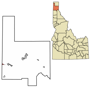
Oldtown is a city in Bonner County, Idaho and suburb of Newport, Washington, with a population of 184 at the 2010 census. It is located on the Pend Oreille River, just east of Newport. There are no natural or physical barriers, and it is strictly a political division, separated by the straight-line state boundary. Oldtown is squeezed between this boundary to the west and the river to the east, leaving the main business district on U.S. Route 2 with only 700 feet of space in which to operate on the Idaho side. Many homes are located in the south end on the other side of the railroad, as the Pend Oreille is somewhat further away here.

<span class="mw-page-title-main">Osceola, Iowa</span> City in Iowa, United States

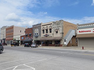
Osceola is a city in Clarke County, Iowa, United States. The population was 5,160 at the time of the 2020 census. It is the county seat of Clarke County.

<span class="mw-page-title-main">Macksburg, Iowa</span> City in Iowa, United States

Macksburg is a city in Madison County, Iowa, United States. The population was 97 at the time of the 2020 census. It is part of the Des Moines–West Des Moines Metropolitan Statistical Area.

<span class="mw-page-title-main">Gilman, Iowa</span> City in Iowa, United States

Gilman is a city in the southeastern corner of Marshall County, Iowa, United States. The population was 542 at the time of the 2020 census.

<span class="mw-page-title-main">Aldrich, Minnesota</span> City in Minnesota, United States

Aldrich is a city in Wadena County, Minnesota, United States, along the Partridge River. The population was 48 at the 2010 census. The small community holds the distinction as the first permanent settlement in Wadena County and the first to establish a post office. It is also home to the first Catholic church in the area, established in 1870, as a mission church.

<span class="mw-page-title-main">Winfield, Missouri</span> City in Missouri, United States

Winfield is a city in Lincoln County, Missouri, United States. The population was 1,404 at the 2010 census.

<span class="mw-page-title-main">Clearwater, Nebraska</span> Village in Antelope County, Nebraska, United States

Clearwater is a village in Antelope County, Nebraska, United States. The population was 419 at the 2010 census.

<span class="mw-page-title-main">Long Pine, Nebraska</span> City in Brown County, Nebraska, United States

Long Pine is a city in Brown County, Nebraska, United States. The population was 305 at the 2010 census.

<span class="mw-page-title-main">Sidney, Nebraska</span> City in Nebraska, United States

Sidney is a city in and the county seat of Cheyenne County, Nebraska, United States. The city is nine miles (14 km) north of the Colorado state line. The population was 6,757 at the 2010 census.

<span class="mw-page-title-main">Snyder, Nebraska</span> Village in Nebraska, United States

Snyder is a village in Dodge County, Nebraska, United States. The population was 300 at the 2010 census.

<span class="mw-page-title-main">Milligan, Nebraska</span> Village in Nebraska, United States

Milligan is a village in Fillmore County, Nebraska, United States. The population was 241 at the 2020 census.

<span class="mw-page-title-main">Hayes Center, Nebraska</span> Village in Hayes County, Nebraska, United States

Hayes Center is a village in Hayes County, Nebraska, United States, which has served as that county's county seat since 1885. Its population, according to the 2010 U.S. census, was 214.

<span class="mw-page-title-main">Atkinson, Nebraska</span> City in Nebraska, United States

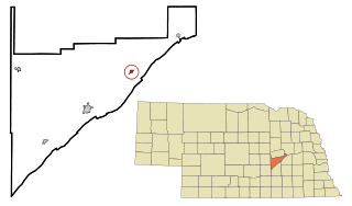
Atkinson is a city in Holt County, Nebraska, United States. The population was 1,245 at the 2010 census.

<span class="mw-page-title-main">Chambers, Nebraska</span> Village in Nebraska, United States

Chambers is a village in Holt County, Nebraska, United States. The population was 268 at the 2010 census.

<span class="mw-page-title-main">Emmet, Nebraska</span> Village in Holt County, Nebraska, United States

Emmet is a village in Holt County, Nebraska, United States. The population was 48 at the 2010 census.

<span class="mw-page-title-main">Inman, Nebraska</span> Village in Nebraska, United States

Inman is a village in Holt County, Nebraska, United States. The population was 129 as of the 2010 census.

<span class="mw-page-title-main">Clarks, Nebraska</span> Village in Nebraska, United States

Clarks is a village in Merrick County, Nebraska, United States. The population was 344 at the 2020 census. It is part of the Grand Island, Nebraska Micropolitan Statistical Area.

<span class="mw-page-title-main">Tilden, Nebraska</span> City in Antelope and Madison counties in Nebraska, United States

Tilden is a city in Antelope and Madison counties in Nebraska, United States. The population was 953 at the 2010 census. The Madison County portion of Tilden is part of the Norfolk, Nebraska Micropolitan Statistical Area.

References

  1. 1 2 "O'Neill Nebraska". City-Data.com. Retrieved October 19, 2012.
  2. "ArcGIS REST Services Directory". United States Census Bureau. Retrieved September 18, 2022.
  3. 1 2 U.S. Geological Survey Geographic Names Information System: O'Neill, Nebraska
  4. "Find a County". National Association of Counties. Retrieved June 7, 2011.
  5. Fitzpatrick, Lillian L. (1960). Nebraska Place-Names. University of Nebraska Press. p. 78. ISBN   0-8032-5060-6. A 1925 edition is available for download at University of Nebraska—Lincoln Digital Commons.
  6. "Profile for O'Neill City, Nebraska, NE". ePodunk. Archived from the original on July 1, 2017. Retrieved October 19, 2012.
  7. "O'Neill, Holt County". Center for Advanced Land Management Information Technologies. University of Nebraska. Retrieved August 13, 2014.
  8. "US Gazetteer files 2010". United States Census Bureau. Archived from the original on July 2, 2012. Retrieved June 24, 2012.
  9. "O'Neill, Irish Capital of Nebraska". [usurped] Nebraska State Historical Society. [usurped] Retrieved 2010-04-19.
  10. "NOWData - NOAA Online Weather Data". National Oceanic and Atmospheric Administration. Retrieved November 27, 2021.
  11. "Station: O'Neill, NE". U.S. Climate Normals 2020: U.S. Monthly Climate Normals (1991-2020). National Oceanic and Atmospheric Administration. Retrieved November 27, 2021.
  12. United States Census Bureau. "Census of Population and Housing" . Retrieved October 18, 2013.
  13. "Annual Estimates of the Resident Population: April 1, 2010 to July 1, 2012". Archived from the original on June 2, 2013. Retrieved October 18, 2013.
  14. "U.S. Census website". United States Census Bureau . Retrieved June 24, 2012.
  15. Seaman, Tim (March 16, 2017). "World's Largest painted Shamrock returns to O'Neill". Siouxland Proud . Retrieved January 3, 2018.
  16. Nebraska Game and Parks Commission, "The Cowboy Trail" Archived 2010-01-06 at the Wayback Machine , Retrieved 2010-03-03.
  17. "Kelsey Bray, Blazin' saddle" . Wyoming Tribune-Eagle . Retrieved September 23, 2013.
  18. Haugen, Jean Mathisen (November 23, 2014). "A Little Bit of History: Clayton Danks – Bronc Rider and Sheriff". County 10 – Community News Stream. Retrieved January 5, 2018.
  19. "Helen Duhamel: Hall of Fame 1992". Nebraska Broadcasters’ Association Hall of Fame. Omaha, Nebraska: Nebraska Broadcasters’ Association. 1992. Retrieved April 10, 2012.
  20. "Celebrating Priesthood- Father Edward J. Flanagan". The Dominican Friars – England & Scotland. Retrieved February 1, 2021.
  21. "Nebraska – Biography Campaign Finance Summary Top PAC Donations Michael Owen Johanns". Las Vegas Review-Journal . Associated Press. February 18, 2013.
  22. "KINKAID, Moses Pierce, (1856 - 1922)". Biographical Directory of the United States Congress. Retrieved January 7, 2018.
  23. Peterson, Jess (March 16, 2000). "General John C. O'Neill". HistoricOmaha.com. Archived from the original on September 29, 2017. Retrieved January 3, 2018.
  24. "Harry Owens". Discogs . Retrieved January 11, 2018.
  25. Sipple, Steven M. (March 26, 2017). "Husker walk-on Peetz quietly rises in NFL to become Raider QB coach". Lincoln Journal Star . Retrieved January 7, 2018.