White Mountains (New England)

Last updated
White Mountains
White Mountains2010-08-20.JPG
From left to right: Mount Clay, Mount Jefferson, Mount Adams, and Mount Madison viewed from Mount Washington
Highest point
Peak Mount Washington
Elevation 6,288 ft (1,917 m)
Coordinates 44°16′15″N71°18′12.5″W / 44.27083°N 71.303472°W / 44.27083; -71.303472
Geography
NortheastAppalachiansMap.gif
Map of the main regions of the northeast Appalachians
CountryUnited States
States New Hampshire and Maine
Region New England
Range coordinates 44°16′16″N71°18′18″W / 44.271°N 71.305°W / 44.271; -71.305
Parent range Appalachian Mountains

The White Mountains are a mountain range covering about a quarter of the state of New Hampshire and a small portion of western Maine in the United States. They are a subrange of the northern Appalachian Mountains and the most rugged mountains in New England. Several of the higher peaks contain an Alpine tundra. The range is heavily visited due to its proximity to Boston, New York City, and Montreal.

Contents

Most of the area is public land, including the White Mountain National Forest and a number of state parks. Its most famous mountain is 6,288-foot (1,917 m) Mount Washington, which is the highest peak in the Northeastern U.S. and for 76 years held the record for fastest surface wind gust in the world (231 miles per hour (372 km/h) in 1934). Mount Washington is part of a line of summits, the Presidential Range, that are named after U.S. presidents and other prominent Americans.

The White Mountains also include the Franconia Range, Sandwich Range, Carter-Moriah Range and Kinsman Range in New Hampshire, and the Mahoosuc Range straddling the border between it and Maine. In all, there are 48 peaks within New Hampshire as well as one (Old Speck Mountain) in Maine over 4,000 feet (1,200 m), known as the four-thousand footers.

The Whites are known for a system of alpine huts for hikers operated by the Appalachian Mountain Club. The Appalachian Trail crosses the area from southwest to northeast.

Etymology

It is not clear where the name "White Mountains" came from. There is no record of what Native Americans called the range, although pre-Colonial names for many individual peaks are known. [1] The name and similar ones such as "White Hills" or "Wine Hills" are found in literature from Colonial times. According to tradition, the mountains were first sighted from shipboard off the coast near the Piscataqua estuary. The highest peaks would often be snow-capped, appearing white. An alternate theory is that the mica-laden granite of the summits looked white to observers.

Geology and physiography

The White Mountains are a physiographic section of the larger New England province, which in turn is part of the larger Appalachian Highlands physiographic division. [2]

The magma intrusions forming the White Mountains today were created 124 to 100 million years ago as the North American Plate moved westward over the New England hotspot.

Widespread evidence of glaciation may be seen in the U-shaped form of various notches, or mountain passes. Glacial cirques form the heads of Tuckerman Ravine on Mt. Washington and King Ravine on Mt. Adams. Glacial striations are visible at numerous locations, including on the exposed rocks at the summit of Pine Mountain in Gorham.

The Red Hill Syenite, a rock unit of the White Mountains, found in central New Hampshire, is of interest to researchers due to the fact that it contains feldspathoids as well as quartz-bearing rocks.

Attractions

The White Mountain National Forest, formed in 1911 after passage of the Weeks Act, includes most of the mountain range and now covers 800,000 acres (3,200 km2) in New Hampshire and western Maine. [3] The Mount Washington Auto Road and Mount Washington Cog Railway ascend the range's highest peak, which hosts a visitor center and weather observatory. Heavily visited Arethusa Falls, the second tallest waterfall in New Hampshire, lies on a southwest flank of Crawford Notch. The Old Man of the Mountain, a rock formation on Cannon Mountain that resembled the craggy profile of a man's face, was a White Mountain landmark until it fell in May 2003. It remains the state symbol of New Hampshire. The range also includes a natural feature dubbed "The Basin", consisting of a granite bowl, 20 feet (6 m) in diameter, fed by a waterfall, worn smooth by the Pemigewasset River. The areas around The Basin are popular spots for swimming in the cold water.

The range is crossed north–south by U.S. Route 3 and Interstate 93 through Franconia Notch and New Hampshire Route 16 through Pinkham Notch, and east–west by the Kancamagus Highway (part of New Hampshire Route 112) through Kancamagus Pass and U.S. Route 302 through Crawford Notch. Many of these highways are designated as scenic routes.

Several amusement parks lie in or near the White Mountains, including Story Land, Santa's Village, Whale's Tale Water Park and Clark's Trading Post. The White Mountains region is also home to numerous hiking attractions through the various river gorges, ravines, and caves in the area. The Flume Gorge, Lost River Reservation and Polar Caves Park all provide moderate hikes that one can complete in a few hours. Skiing is a popular attraction in the area. Cannon Mountain Ski Area, Loon Mountain Ski Resort, Attitash Mountain Resort, Wildcat Mountain Ski Area, Bretton Woods Mountain Resort, and Waterville Valley Resort are all popular winter ski resorts, and many of them provide year-round outdoor activities such as bridle paths, hiking trails, alpine slides, and the like. The Mount Washington Hotel located in Bretton Woods was the site of the Bretton Woods Conference following World War II, and today remains one of the few early twentieth century grand hotels still in use. An estimated six million visitors visit the region yearly. [3]

Mapping

Map of the White Mountains, Franklin Leavitt, 1871 Franklin Leavitt map 1871.jpg
Map of the White Mountains, Franklin Leavitt, 1871

Some of the earliest maps of the White Mountains were produced as tourist maps and not topographical maps. One of the first two tourist maps of the mountains was that produced by Franklin Leavitt, a self-taught artist born near Lancaster, New Hampshire in 1824. [4] Leavitt's hand-drawn map, today in the collection of Harvard University, is largely folk art, but does convey some of the region's features. [5] Leavitt drew several versions of his map, beginning in 1852. The fourth version, printed in 1871, was printed at Boston and carried a retail price of one dollar. [6] Other early maps of the region were drawn by H. Conant and by Harvard astronomer George Phillips Bond, who published the first topographical map of the region in 1853. [7]

Art

The White Mountains drew hundreds of painters during the 19th century. This group of artists is sometimes referred to as belonging to the "White Mountain school" of art. Others dispute the notion that these painters were a "school", since they did not all paint in the same style as, for example, those artists of the Hudson River School.

Loon Panorama annotated.jpg
Peaks of the Franconia Range of the White Mountains as viewed from Loon Mountain resort after an October snowfall, looking to the north.

In literature and drama

Nathaniel Hawthorne chose the White Mountains as the setting for his short story "The Great Carbuncle". Other White Mountain tales by Hawthorne include "The Ambitious Guest", "Sketches from Memory" and "The Great Stone Face". The White Mountain region also figures prominently in the writings of Louisa May Alcott, including the novel Eight Cousins and its sequel, Rose in Bloom .

See also

Related Research Articles

<span class="mw-page-title-main">Mount Washington</span> Highest mountain in Northeastern United States

Mount Washington, is an ultra-prominent mountain in the state of New Hampshire. It is the highest peak in the Northeastern United States at 6,288.2 ft (1,916.6 m) and the most topographically prominent mountain east of the Mississippi River.

<span class="mw-page-title-main">Presidential Range</span> Mountain range in the White Mountains of New Hampshire, US

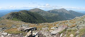
The Presidential Range is a mountain range located in the White Mountains of the U.S. state of New Hampshire. Containing the highest peaks of the Whites, its most notable summits are named for American presidents, followed by prominent public figures of the 18th and 19th centuries. The Presidential Range is notorious for having some of the worst weather on Earth, mainly because of the unpredictability of high wind speeds and whiteout conditions on the higher summits. Because of the poor weather conditions, the Presidential Range is often used for mountaineering training for those who go on to climb some of the world's highest mountains, including K2 and Everest.

<span class="mw-page-title-main">Bretton Woods, New Hampshire</span> Unincorporated community in New Hampshire, United States

Bretton Woods is an area within the town of Carroll, New Hampshire, United States, whose principal points of interest are three leisure and recreation facilities. Being virtually surrounded by the White Mountain National Forest, the vista from Bretton Woods toward Mount Washington and the Presidential Range includes no significant artificial structures other than the Mount Washington Cog Railway and the Mount Washington Hotel.

<span class="mw-page-title-main">Green Mountains</span> Subrange of the Appalachian Mountains in Quebec, Canada and Vermont, United States

The Green Mountains are a mountain range in the U.S. state of Vermont and are a subrange of the Appalachian Mountains. The range runs primarily south to north and extends approximately 250 miles (400 km) from the border with Massachusetts to the border with Quebec, Canada. The part of the same range that is in Massachusetts and Connecticut is known as The Berkshires or the Berkshire Hills and the Quebec portion is called the Sutton Mountains, or Monts Sutton in French.

<span class="mw-page-title-main">White Mountains Region</span>

The White Mountains Region is a tourism region designated by the New Hampshire Division of Travel and Tourism. It is located in northern New Hampshire in the United States and is named for the White Mountains, which cover most of the region. The southern boundary of the region begins at Piermont on the west, and runs east to Campton, then on to Conway and the Maine border. The northern boundary begins at Littleton and runs east to Gorham and the Maine border. The region to the north is known as the Great North Woods Region, which should not be confused with the larger and more general Great North Woods.

<span class="mw-page-title-main">White Mountain National Forest</span> National forest in Maine and New Hampshire, U.S.

The White Mountain National Forest (WMNF) is a federally managed forest contained within the White Mountains in the northeastern United States. It was established in 1918 as a result of the Weeks Act of 1911; federal acquisition of land had already begun in 1914. It has a total area of 750,852 acres (303,859 ha). Most of the WMNF is in New Hampshire; a small part is in the neighboring state of Maine. Conservationist and community activist Katherine Sleeper Walden was instrumental in securing at-risk land for the forest, including thousands of acres in the region surrounding the locally famous Bowl near Wonalancet.

<span class="mw-page-title-main">Franconia Notch State Park</span> State park in New Hampshire, United States

Franconia Notch State Park is a public recreation area and nature preserve that straddles eight miles (13 km) of Interstate 93 as it passes through Franconia Notch, a mountain pass between the Kinsman Range and Franconia Range in the White Mountains of northern New Hampshire, United States. The northern part of the park, including Cannon Mountain and Echo and Profile lakes, is in the town of Franconia, and the southern part, including Lonesome Lake and the Flume, is in Lincoln. Attractions in the state park include the Flume Gorge and visitor center, the Old Man of the Mountain historical site, fishing in Echo Lake and Profile Lake, and miles of hiking, biking and ski trails.

The Western Lakes and Mountains region spans most of Maine's western border with New Hampshire. A small part of the scenic White Mountain National Forest is located in this area. The region consists of Oxford County, Androscoggin County, Franklin County, as well as northern York and interior Cumberland counties. The largest cities in the region are Lewiston and Auburn. Notable towns include Bethel, Bridgton, Oxford, Rangeley, and Rumford. Many of the state's highest peaks are located in the region, although the highest, Mount Katahdin, is not.

<span class="mw-page-title-main">Mount Moosilauke</span> Mountain in the American state of New Hampshire

Mount Moosilauke is a 4,802-foot-high (1,464 m) mountain at the southwestern end of the White Mountains in the town of Benton, New Hampshire, United States. It is the tenth highest and most southwesterly of the 4,000 foot summits in the White Mountains.

<span class="mw-page-title-main">Mount Monroe</span> Mountain in the American state of New Hampshire

Mount Monroe is a 5,372-foot-high (1,637 m) mountain peak southwest of Mount Washington in the Presidential Range of the White Mountains in New Hampshire, United States. It is named for American President James Monroe and is the fourth highest mountain on the 4000 footers list for New Hampshire. The Appalachian Trail skirts its summit, which is the next highest peak on or near the trail north of Mount Rogers in Virginia. The Lakes of the Clouds, and its AMC hut, lie nestled at the col between Mount Monroe and neighboring Mount Washington.

The Mahoosuc Range, a northern extension of the White Mountains, straddles the border between New Hampshire and Maine. The range's highest peak, 4,170-foot (1,270 m) Old Speck Mountain, is the fifth-highest peak in Maine. Substantial parts of the range are publicly owned as parts of the National Park Service Appalachian Trail corridor and Grafton Notch State Park in Maine. The range is a subrange of the Appalachian Mountains.

<span class="mw-page-title-main">Pinkham Notch</span> Mountain pass in New Hampshire

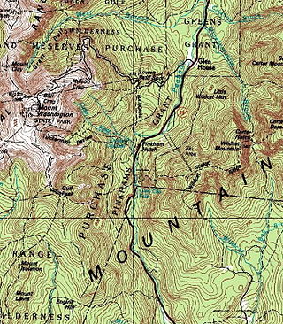
Pinkham Notch is a mountain pass in the White Mountains of north-central New Hampshire, United States. The notch is a result of extensive erosion by the Laurentide Ice Sheet during the Wisconsinian ice age. Pinkham Notch was eroded into a glacial U-shaped valley whose walls are formed by the Presidential, Wildcat, and Carter-Moriah ranges. Due to the volatility of the area's climate and rugged character of the terrain, a number of rare or endemic ecosystems have developed throughout the notch.

The Appalachian National Scenic Trail spans 14 U.S. states over its roughly 2,200 miles (3,500 km): Georgia, North Carolina, Tennessee, Virginia, West Virginia, Maryland, Pennsylvania, New Jersey, New York, Connecticut, Massachusetts, Vermont, New Hampshire, and Maine. The southern end is at Springer Mountain, Georgia, and it follows the ridgeline of the Appalachian Mountains, crossing many of its highest peaks and running almost continuously through wilderness before reaching the northern end at Mount Katahdin, Maine.

<span class="mw-page-title-main">Wildcat Mountain (New Hampshire)</span>

Wildcat Mountain is a mountain located in Coos County, northern New Hampshire, United States. The mountain is part of the Carter-Moriah Range of the White Mountains, on the east side of Pinkham Notch. Wildcat Mountain faces Carter Dome across Carter Notch to the northeast, and Mount Washington across Pinkham Notch to the west.

<span class="mw-page-title-main">Mount Hancock (New Hampshire)</span>

Mount Hancock is a mountain in Grafton County, New Hampshire, named after John Hancock (1737–1793), one of the Founding Fathers of the United States.

<span class="mw-page-title-main">Boott Spur</span> Mountain in New Hampshire, United States

Boott Spur is a minor peak located in Coos County, New Hampshire, United States. The mountain is named after Francis Boott (1792–1863), and is part of the Presidential Range of the White Mountains. Boott Spur stands on the shoulder of Mount Washington, above the south side of the headwall of Tuckerman Ravine.

<span class="mw-page-title-main">Sandwich Range</span> Mountain range in the American state of New Hampshire

The Sandwich Range is located in the White Mountains of New Hampshire in the United States, north of the Lakes Region and south of the Kancamagus Highway. Although the range is not outstanding for its elevation, it is very rugged and has excellent views of the surrounding lakes, mountains, and forests.

<span class="mw-page-title-main">Ragged Mountain (New Hampshire)</span> Mountain in the American state of New Hampshire

Ragged Mountain is a low mountain with numerous knobby summits in the towns of Danbury and Andover in central New Hampshire. It is home to the Ragged Mountain ski resort.

<span class="mw-page-title-main">Mount Willey</span> Mountain in the state of New Hampshire

Mount Willey is a mountain located in Grafton County, New Hampshire. The mountain is named after Samuel Willey, Jr. (1766–1826) and his family, who in 1825 moved into a house in Crawford Notch. The family was killed a year later in August 1826 during a landslide.

<span class="mw-page-title-main">Smugglers' Notch State Park</span> State park in Vermont, United States

Smugglers' Notch State Park is a Vermont state park near Stowe in Lamoille County, Vermont, United States. The park is at an elevation of 2,119 feet (646 m) near Mount Mansfield, and is named for Smugglers Notch, which separates Mount Mansfield—the highest peak of the Green Mountains—from Spruce Peak and the Sterling Range.

References

  1. AMC: "How the White Mountains Were Named"
  2. "Physiographic divisions of the conterminous U. S." U.S. Geological Survey. Retrieved 2007-12-06.
  3. 1 2 "White Mountain National Forest" (PDF).
  4. Franklin Leavitt, Map of the White Mountains, New Hampshire, WhiteMountainHistory.org
  5. Franklin Leavitt White Mountains Map, Harvard University
  6. 1871 Franklin Leavitt Map, WhiteMountainHistory.org
  7. George P. Bond: Map of the White Mountains of New Hampshire, WhiteMountainHistory.org